A risk of heavy rain for the Maritimes on Wednesday, not directly related to Hurricane Franklin
 A pedestrian shields herself from the rain with an umbrella while walking downtown in Halifax on Monday, October 30, 2017. (THE CANADIAN PRESS/Darren Calabrese)
Rain, potentially heavy for some areas, is expected in the Maritimes on Wednesday.
That rain is not directly related to Hurricane Franklin. Franklin will still be located just over 1,000 kilometres to the south of Nova Scotia on Wednesday, the associated rain with the storm falling over the open ocean waters of the Atlantic.
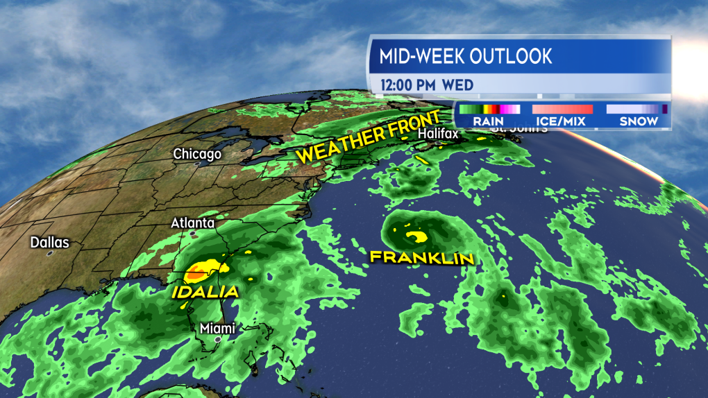 A weather front moves into the Maritimes Wednesday. Franklin far to the south, and Idalia moving across Florida. (CTV/Kalin Mitchell)
The Wednesday rain in the Maritimes is a result of a weather front in the eastern U.S. meeting up with a second front arriving out of Quebec. There may be some water vapour drawn off of Franklin high in the atmosphere that could reach that weather front.
The Canadian Hurricane Centre noted that “some moisture from Franklin could feed into this system possibly resulting in enhanced rainfall in some areas” in a post to social media Monday. 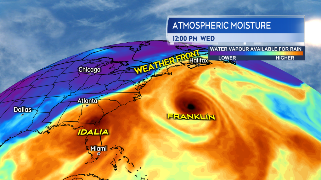 It is possible that high level water vapour will flow north off of Hurricane Franklin and gets tied up in the rain the will front bring Wednesday. (CTV/Kalin Mitchell) What can be expected in the Maritimes?
Increasing cloudiness during the day on Tuesday will be followed by the arrival of some light to moderate rain on Tuesday night. Rain becomes steady on Wednesday, possibly heavy at times for some areas. The steady rain then clears western parts of the Maritimes on Wednesday evening and eastern parts of the Maritimes early Thursday morning.
Around 10 to 40 mm of rain looks likely for most of the Maritimes which is fairly “standard” rain by our standards.
There is a possibility of some totals that could reach or exceed 50 mm in 24 hours. Currently, it looks like Halifax across eastern mainland Nova Scotia and Cape Breton may be at higher risk of that heavier rain. Some weather models do have risk of heavier rain further west in the region.
It is recommended to check the forecast for your area Tuesday as a change in expected amounts for specific locations is possible.
Some gustier winds will accompany the rain on Wednesday but are not expected to be a big issue at this time. Initially from the southwest they will be sustained 20 to 30 km/h with gusts 30 to 60 km/h. The wind is then expected to become west and northwest Wednesday night into Thursday morning.
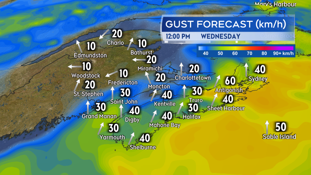 Gusty winds accompany the rain Wednesday but aren’t expected to be a major issue for the region at this time. (CTV/Kalin Mitchell) Updates on the rain expected on CTV Atlantic News Five, Six, and Late.
Shopping Trends
The Shopping Trends team is independent of the journalists at CTV News. We may earn a commission when you use our links to shop. Read about us.


CTVNews.ca Top Stories

Plane burst into flames after skidding off runway at an airport in South Korea, killing at least 47
South Korean emergency officials say that 47 people are dead after a plane caught fire during landing at an airport in the country's south.
Canadian model Dayle Haddon dies from suspected carbon monoxide poisoning
Dayle Haddon, an actor, activist and trailblazing former 'Sports Illustrated' model who pushed back against age discrimination by reentering the industry as a widow, has died in a Pennsylvania home from what authorities believe was carbon monoxide poisoning.
Trump appears to side with Musk, tech allies in debate over foreign workers roiling his supporters
U.S. president-elect Donald Trump appears to be siding with Elon Musk and his other backers in the tech industry as a dispute over immigration visas has divided his supporters.
Mississauga tow truck driver charged for impersonating a cop in northern Ont.
A southern Ontario resident has been charged for allegedly impersonating a peace officer during a towing incident in northwestern Ontario.
Vancouver man defrauded Chinese developers of US$500K, court rules
A Vancouver man has been ordered to pay more than US$500,000 after a B.C. Supreme Court judge found he had defrauded the would-be developers of a real estate project in China of that amount.
15 hurt when passenger train strikes fire truck that drove into crossing after freight train passed
Three firefighters and a dozen passengers were injured in Florida on Saturday when a fire truck drove around rail crossing arms and into the path of a high-speed passenger train after waiting for another train to pass, according to a person briefed on what happened.
G2 driver stopped going more than 100 km/h over the speed limit on Hwy. 401 in eastern Ontario
A 17-year-old driver is facing charges after being caught speeding and driving dangerously on Highway 401 in eastern Ontario Friday evening, according to the Ontario Provincial Police (OPP).
If you're mentally struggling during the holidays, here’s how to cope
For many people, celebrating New Year’s Day can include reflecting on a life well lived or a chance to start anew. But for some, the holiday may have dark undertones, according to a recent large study.
Physical therapy is 'the best-kept secret in health care'
If you think physical therapy is only about rehabilitation after surgery or recovering from an accident, think again. For the vast majority, seeing a physical therapist should be about prevention, routine assessment and staying well.
Toronto
-

SIU investigating after Toronto cops discharge sock round, less-lethal firearm at man that resulted in serious injuries
The province’s police watchdog is investigating after Toronto officers discharged sock round and less-lethal firearm at a man who had allegedly stabbed another person in the city’s Rockcliffe-Smythe area on Saturday morning.
-
Toronto, GTA to see ‘significant rainfall’ on Sunday
Toronto and neighbouring areas are expected to see “significant rainfall” on Sunday. Environment Canada has issued a rainfall warning for most of the Greater Toronto Area.
-
1 person in hospital, suspect in police custody following stabbing in Fairbank
One person is in hospital, and a suspect is in custody following a stabbing in Toronto’s Fairbank neighbourhood on Saturday.
Calgary
-

1 arrested after 3 stabbed in Airdrie, inluding 2 youth
Airdrie RCMP have arrested a male in connection with multiple aggravated assaults that left three people injured.
-
Danielle Smith meet-and-greet with Calgary Chinese community wins some hearts but not all
Danielle Smith dropped by the Edgemont Community Association for a meet-and-greet Saturday with some member's of Calgary's Chinese community to answer questions and press the flesh, but a format change left Helen Yu feeling a little shortchanged.
-
Calgary Skyview MP George Chahal joins growing chorus of Liberals calling for Trudeau to step down
Calgary Liberal MP George Chahal has publicly released letters he sent to the Liberal caucus and president of the Liberal Party of Canada, calling on them to begin the process of moving on from Prime Minister Justin Trudeau.
Edmonton
-

Edmonton street photographer captures moments and people one frame at a time
A local photographer who is passionate about capturing moments in one-hundredth of a second embraced many styles of his trade before landing on one which truly represents his mantra: street photography.
-
2 vehicles fall through ice at Sylvan Lake, promoting police warning
RCMP issued a warning Saturday after two vehicles fell through the ice on Sylvan Lake.
-
Late OT goal helps lift Kings past Oilers 4-3
Quinton Byfield scored his second goal of the game with 1:41 remaining in overtime as the Los Angeles Kings beat the Edmonton Oilers 4-3 on Saturday.
Montreal
-

Friend of Quebec man killed in Florida boat explosion says his sister also injured
A childhood friend of the Quebec man killed in a Florida boat explosion earlier this week says one of the victim's sisters was among the other six passengers injured in the blast.
-
Women’s hockey looks to expand coverage and support as spotlight grows
More girls and women than ever are lacing up their skates and hitting the ice. The rising popularity of women's hockey is driven by inspiration believes hockey coach Hanna Bunton
-
Here's how you can watch CTV News Montreal at Six on Saturday during the NFL season
With CTV broadcasting NFL football games on Saturday this season, CTV News Montreal at Six will be broadcasting live on our website and the CTV News App.
Ottawa
-
 FREEZING DRIZZLE ADVISORY
FREEZING DRIZZLE ADVISORY Slippery road conditions expected in Ottawa with freezing drizzle tonight
Environment Canada has issued a freezing drizzle advisory, warning of slippery road conditions tonight.
-
What's happening in Ottawa over the Christmas holidays
CTVNewsOttawa.ca looks at things to do in Ottawa over the holiday season.
-
G2 driver stopped going more than 100 km/h over the speed limit on Hwy. 401 in eastern Ontario
A 17-year-old driver is facing charges after being caught speeding and driving dangerously on Highway 401 in eastern Ontario Friday evening, according to the Ontario Provincial Police (OPP).
London
-

St. Thomas fraud victim loses nearly $100K to job scam
According to police, the victim was investing money into a company that they believed they were employed by for over a month.
-
Ending the year with above seasonal temperatures
Warmer conditions are expected in the London, Ont. region this weekend, with the high forecast in the double digits.
-
Trudeau, Carney push back over Trump's ongoing 51st state comments
Two senior members of the federal cabinet were in Florida Friday pushing Canada's new $1.3 billion border plan with members of Donald Trump's transition team, a day after Prime Minister Justin Trudeau himself appeared to finally push back at the president-elect over his social media posts about turning Canada into the 51st state.
Barrie
-

Deluxe taxi goes up in flames in Barrie parking lot
Some locals were quick to pull out their cellphones and capture a minivan as it went up in hot flames in a Barrie parking lot.
-
Boxing Day bust: Police allege shopper stole from LCBO amid holiday rush
While Boxing Day is known for securing the best deals, one local shopper took things too far and allegedly tried to score a deal at a free cost.
-
County Road 56 reopens following afternoon collision
County Road 56 in Essa Township was closed for an afternoon collision.
Northern Ontario
-

Pair of 911 calls leads to two impaired driving arrests in three hours
A pair of 911 calls from concerned citizens led to two separate impaired driving charges in a single northern Ontario town within three hours.
-
Calgary Skyview MP George Chahal joins growing chorus of Liberals calling for Trudeau to step down
Calgary Liberal MP George Chahal has publicly released letters he sent to the Liberal caucus and president of the Liberal Party of Canada, calling on them to begin the process of moving on from Prime Minister Justin Trudeau.
-
Five southern Ont. hunters fined $37K for moose hunt offences in northern Ont.
A multi-year moose hunting investigation resulted in five people being convicted of moose hunting offences and fined a total of $37,000, plus $9,250 in victim surcharges.
Kitchener
-

Cambridge industrial plant dealing with major damages after fire
A fire Saturday morning has a Cambridge industrial plant dealing with major damage.
-
Minor flooding possible with snow melt, rain on way: GRCA
The Waterloo Region and the city of Guelph will be wrapping up 2024 with unusually warm weather over the weekend.
-
Stretch of Kitchener road closed after gas leak at abandoned building
Kitchener Fire is investigating after a "strange odor" was reported on Courtland Avenue East Saturday.
Windsor
-

Community partners in Windsor propose education campaign to veer people away from payday loans
In a move aimed at combatting the financial strain caused by payday loans, the City of Windsor is considering the launch of a comprehensive education campaign to promote alternative financial options.
-
Ex-boyfriend arrested for violating bail conditions
Chatham-Kent police have made an arrest after a man allegedly violated his bail conditions.
-
Trudeau, Carney push back over Trump's ongoing 51st state comments
Two senior members of the federal cabinet were in Florida Friday pushing Canada's new $1.3 billion border plan with members of Donald Trump's transition team, a day after Prime Minister Justin Trudeau himself appeared to finally push back at the president-elect over his social media posts about turning Canada into the 51st state.
Winnipeg
-

The most-read stories on CTV Winnipeg in 2024
Historic events, community pride and significant losses dominated headlines in Manitoba in 2024. Here’s a list of the most-read stories of each month of 2024 on CTV News Winnipeg.
-
Cross-country ski race returns to Windsor Park
The Prairie Holiday Loppet made its long-awaited return to Winnipeg’s Windsor Park Saturday, with dozens of racers hitting the trails.
-
Have you seen Genevieve? RCMP search for woman last seen on Christmas Eve
Thompson RCMP are searching for a woman who went missing from Split Lake earlier this week.
Regina
-

Regina man showcases local bead supply business
Jeramy Hannah recently began selling beading supplies, after he realized the beaders in his life were struggling with a lack of local vendors, prompting him to create a business called Bead Bro.
-
'A great holiday memory': Echo Valley Provincial Park gets plenty of visitors at Skate the Park launch
Families and groups of friends made use of the good weather as the new season of Skate the Park got underway at Echo Valley Provincial Park.
-
Saskatoon
-

U18 provincials curling tournament underway in PA
Teams from across Saskatchewan are in Prince Albert for the U18 curling provincials.
-
Police made two arrests following a shooting in Saskatoon
A swift response from Saskatoon police led to the arrest of a man and woman following a reported shooting Friday afternoon.
-
Saskatoon fire crews battle house fire
Saskatoon firefighters responded to a house fire on the 100 block of Klassen Crescent Friday afternoon.
Vancouver
-

Vancouver man defrauded Chinese developers of US$500K, court rules
A Vancouver man has been ordered to pay more than US$500,000 after a B.C. Supreme Court judge found he had defrauded the would-be developers of a real estate project in China of that amount.
-
Vince Dunn's second goal comes in overtime as Kraken rally past Canucks 5-4
Vince Dunn scored his second goal of the game 2:15 into overtime as the Seattle Kraken rallied from a three-goal, third-period deficit to defeat the Vancouver Canucks 5-4 on Saturday afternoon.
-
Burnaby RCMP investigating bear spray incident at Metrotown
Mounties in Burnaby are investigating after several bystanders were affected by bear spray outside the Metrotown mall Friday evening.
Vancouver Island
-

Victoria police seek witnesses, additional victims after hit-and-run spree
A woman is facing seven charges after allegedly committing multiple hit-and-run crashes in a stolen vehicle while impaired, according to police in B.C.'s capital.
-
Vancouver man defrauded Chinese developers of US$500K, court rules
A Vancouver man has been ordered to pay more than US$500,000 after a B.C. Supreme Court judge found he had defrauded the would-be developers of a real estate project in China of that amount.
-
New Canadians, non-traditional demographics boost minor hockey uptake in B.C.
Participation in hockey in British Columbia was struggling in 2021 — the pandemic had dealt a heavy blow to player registrations, and numbers had already been flagging before COVID-19 arrived.
Kelowna
-

B.C. team building 100 beaver 'starter homes' in the name of wetland preservation
More than 70 manmade beaver dams have been installed in Interior waterways since the B.C. Wildlife Federation project launched last year with the goal of building 100 dams by the end of 2025.
-
B.C. man charged with drug trafficking and weapons offences after CBSA investigation
A resident of B.C.'s Interior has been charged with weapon and drug trafficking offences after an investigation launched by border agents at Vancouver International Airport earlier this year.
-
B.C woman awarded nearly $750K in court case against contractor
A B.C. woman has been awarded nearly $750,000 in damages in a dispute with a contractor who strung her along for a year and a half and failed to complete a renovation, according to a recent court decision.


