Cold front to sweep mix of snow, rain across the Maritimes Thursday
A low-pressure system moving north of the St. Lawrence River valley will sweep a cold front across the Maritimes on Thursday. The front will bring a mixture of rain and snow with a chance that eastern areas of Nova Scotia could see lingering snow into Friday.
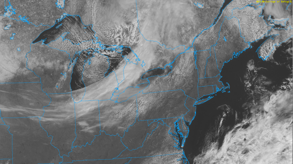 The sweeping arc of the cloud associated with the cold front is pictured as it moves into southern Ontario on satellite imagery. (Courtesy: College of DuPage)The snow arrives for the westernmost communities of New Brunswick between 5 a.m. and 8 a.m. Thursday. By the afternoon, snow will have filled in across New Brunswick with a mix of rain and snow in western Nova Scotia. Thursday evening will see snow in Prince Edward Island and eastern Nova Scotia, including Cape Breton. There will be a chance of flurries for most of the Maritimes Thursday night but with lingering snow expected for eastern areas of Nova Scotia into Friday morning.
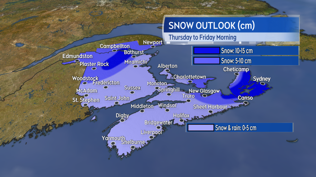
 A mix of snow and rain develops across the western half of the Maritimes Thursday morning into afternoon.A large area of the Maritimes will likely see a snowfall of five cm or less on Thursday. Exceptions include the northwestern corner of New Brunswick where five to 10 cm, with 10 to 15 cm in higher terrain, looks likely. Five to 10 cm of snow also looks possible for Charlottetown and east in P.E.I. and on the North Shore of mainland Nova Scotia. With snow lingering into Friday morning, 10 to 15 cm may end up falling from Antigonish across the causeway into Cape Breton, with amounts lowering to near five cm or less for coastal areas of Inverness County, Cape Breton. There is a risk there will be further accumulating snow for Cape Breton through the day on Friday.
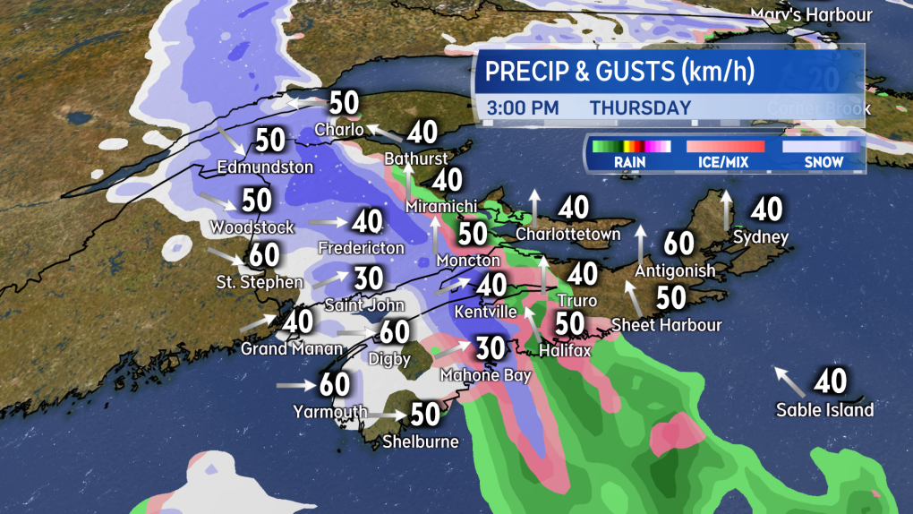
Given the strength of the weather front, higher precipitation rates are possible as it moves through. The snow or rain-snow mix may come down heavy for a period of time. Be cautious of reduced visibility if travelling through the snow or rain.
 Locally higher snow amounts are possible in the northwest of New Brunswick as well as eastern areas of P.E.I. and N.S. where the snow may linger into Friday morning.Gusty winds will accompany the passage of the front. Initially from the south on Thursday, peak gusts could reach 40 to 60 km/h. After the front goes through, the wind direction will change to northwest with further gusts of 40 to 60 km/h, while exposed areas of the coast in southwestern Nova Scotia will see some peak gusts of 50 to 70 km/h Thursday night into early Friday morning. The change to a northwest wind will knock low temperatures down a few to several degrees below freezing Thursday night. Wet or slushy surfaces could turn icy Friday morning.
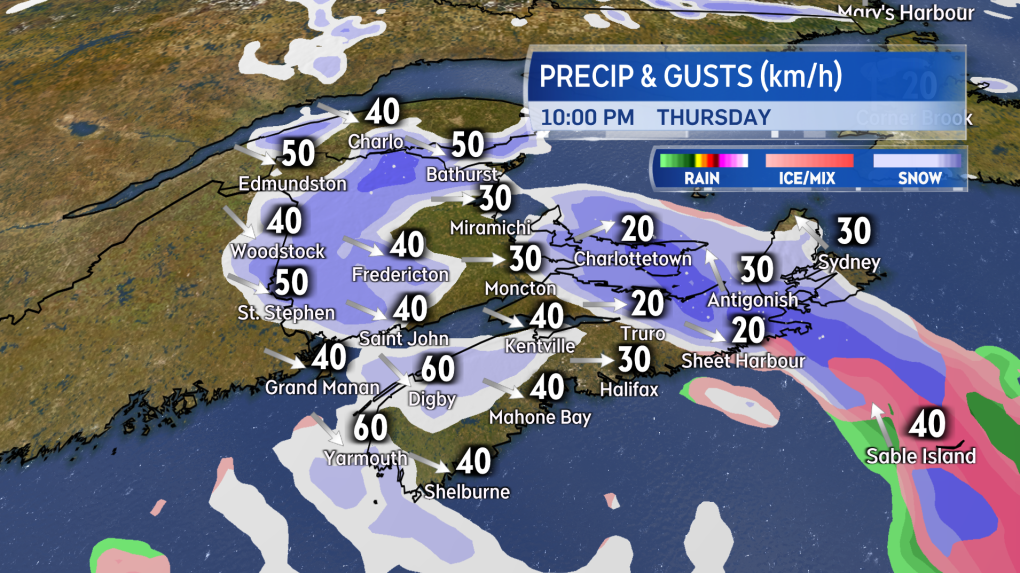 Scattered flurries are expected for much of the Maritimes Thursday night. Steady and accumulating snow will continue for eastern P.E.I. and eastern areas of N.S., including Cape Breton. There will also be gusty winds around the front.I’ll have more on the timing of the cold front, regional conditions, and forecast updates on CTV News Atlantic 5, 6, and 11:30 p.m.


CTVNews.ca Top Stories

Quebec nurse had to clean up after husband's death in Montreal hospital
On a night she should have been mourning, a nurse from Quebec's Laurentians region says she was forced to clean up her husband after he died at a hospital in Montreal.
Northern Ont. lawyer who abandoned clients in child protection cases disbarred
A North Bay, Ont., lawyer who abandoned 15 clients – many of them child protection cases – has lost his licence to practise law.
Bank of Canada officials split on when to start cutting interest rates
Members of the Bank of Canada's governing council were split on how long the central bank should wait before it starts cutting interest rates when they met earlier this month.
Maple Leafs fall to Bruins in Game 3, trail series 2-1
Brad Marchand scored twice, including the winner in the third period, and added an assist as the Boston Bruins downed the Toronto Maple Leafs 4-2 to take a 2-1 lead in their first-round playoff series Wednesday
Cuban government apologizes to Montreal-area family after delivering wrong body
Cuba's foreign affairs minister has apologized to a Montreal-area family after they were sent the wrong body following the death of a loved one.
'It was instant karma': Viral video captures failed theft attempt in Nanaimo, B.C.
Mounties in Nanaimo, B.C., say two late-night revellers are lucky their allegedly drunken antics weren't reported to police after security cameras captured the men trying to steal a heavy sign from a downtown business.
What is changing about Canada's capital gains tax and how does it impact me?
The federal government's proposed change to capital gains taxation is expected to increase taxes on investments and mainly affect wealthy Canadians and businesses. Here's what you need to know about the move.
New Indigenous loan guarantee program a 'really big deal,' Freeland says at Toronto conference
Canada's Deputy Prime Minister Chrystia Freeland was among the 1,700 delegates attending the two-day First Nations Major Projects Coalition (FNMPC) conference that concluded Tuesday in Toronto.
'Life was not fair to him': Daughter of N.B. man exonerated of murder remembers him as a kind soul
The daughter of a New Brunswick man recently exonerated from murder, is remembering her father as somebody who, despite a wrongful conviction, never became bitter or angry.
Shopping Trends
The Shopping Trends team is independent of the journalists at CTV News. We may earn a commission when you use our links to shop. Read about us.


Toronto
-

An Ont. township has been without a full supermarket for nearly a year. Residents just learned it won't reopen
A township east of Toronto has been without its only full supermarket for nearly a year after it was destroyed in a fire. On Tuesday, residents learned it won't reopen.
-
Delivery truck driver dead after collision at industrial complex in Mississauga
A delivery truck driver is dead after a collision in an industrial complex in Mississauga Wednesday afternoon.
-
Maple Leafs fall to Bruins in Game 3, trail series 2-1
Brad Marchand scored twice, including the winner in the third period, and added an assist as the Boston Bruins downed the Toronto Maple Leafs 4-2 to take a 2-1 lead in their first-round playoff series Wednesday
Calgary
-

Coyote calls on the rise in Calgary; city wildlife team advises caution
The City of Calgary's wildlife team says they're fielding hundreds of calls about coyotes.
-
Mounties respond to serious crash near Okotoks, Alta.
A serious vehicle collision near Okotoks, Alta., shut down roadways on Wednesday evening.
-
Auburn Bay community members rally around grieving widow, three young children
Residents of one southeast Calgary neighbourhood have raised thousands of dollars to support a family grieving the losses of a father and grandfather.
Edmonton
-

Nurse practitioners to make 80% as much as family doctors for publicly-funded primary care
The Alberta government says it will pay nurse practitioners 80 per cent of what family doctors are paid – if they want to practice comprehensive primary care.
-
MacTavish on Oilers-Kings Game 2: 'It's going to be a completely different game'
Former Oilers player, coach and general manager Craig MacTavish talks to CTV News Edmonton's Matt Woodman about playoff hockey and Game 2 between Edmonton and Los Angeles.
-
Measles case in Edmonton prompts exposure warning
Alberta Health Services issued a measles alert in Edmonton Wednesday after confirming a case.
Montreal
-
Quebec nurse had to clean up after husband's death in Montreal hospital
On a night she should have been mourning, a nurse from Quebec's Laurentians region says she was forced to clean up her husband after he died at a hospital in Montreal.
-
Woman, 37, dies after being hit by truck; police say driver could face impaired driving charges
A woman died after she was struck by a truck Wednesday afternoon in Montreal's Rivière-des-Prairies--Pointe-aux-Trembles borough.
-
REM delayed: Stations in West Island, North Shore now opening in 2025
Officials for Montreal's REM line confirmed that the lines to the West Island and the North Shore are being delayed and won't open until 2025.
Ottawa
-

NCC buys golf course near Gatineau Park for $3.9 million
The National Capital Commission has purchased the old Dunnderosa Golf Course in Chelsea, Que., as part of its plan to acquire private properties in Gatineau Park.
-
Can cars and bikes fit on the Queen Elizabeth Driveway and Colonel By Drive?
There are questions about how the National Capital Commission might fit bike lanes on the Queen Elizabeth Driveway and Colonel By Drive.
-
Eastern Ont. knitters make 80 peacekeeper 'Izzy Dolls' for D-Day anniversary
Volunteers in Perth, Ont. have knit small peacekeeper "Izzy Dolls" that will be sent to France in commemoration of the 80th anniversary of D-Day and the Battle of Normandy.
London
-

'You made me look for money while he bled on the floor': Man sentenced in manslaughter case nearly a decade after botched robbery
Nine years after a London, Ont. man was shot to death in a botched robbery at his home, the man responsible for the shooting was given a prison sentence on Wednesday.
-
Protest at shuttered auto parts maker over unpaid severance
Frustrated employees of Wescast’s shuttered auto parts manufacturer in Wingham, Ont. will be sending a message to their former ownership on Thursday.
-
'I think 110 is fast enough': Speed limit to increase on some sections of 400 series highways
The speed you travel on sections of 400 series highways in our region is increasing. The province says it will raise the speed limit to 110 km/h on multiple sections, including some in the London region.
Barrie
-

OPP confirm remains found are missing Thornbury man
OPP have confirmed that human remains found in Georgian Bay Township belong to 60-year-old Eric Spencer, who went missing in 2018.
-
Simcoe County Rovers FC make history in Toronto
It was a history-making night on Wednesday for Simcoe County Rovers FC, as the semi-pro team faced off against MLS team, Toronto FC.
-
U.S. Marshals join search for Wasaga Beach kidnapping suspect
U.S. Marshals joins search for Deshawn Davis, one of Canada’s most wanted, accused of the kidnapping of Elnaz Hajtamiri in Wasaga Beach January 2022 and the suspect in a nightclub shooting that took place in May of last year.
Northern Ontario
-

Northern Ont. lawyer who abandoned clients in child protection cases disbarred
A North Bay, Ont., lawyer who abandoned 15 clients – many of them child protection cases – has lost his licence to practise law.
-
Garden River chief meets with disgruntled band members over payout concerns
Some members of the Garden River First Nation are demanding answers regarding the disbursement of the Robinson-Huron Treaty settlement funds.
-
'My stomach dropped': Winnipeg man speaks out after being criminally harassed following single online date
A Winnipeg man said a single date gone wrong led to years of criminal harassment, false arrests, stress and depression.
Kitchener
-

Ont. teacher says she's being forced to switch pharmacies to maintain medication coverage
A Waterloo, Ont. teacher says she’s frustrated after learning the arthritis medication she depends on is no longer covered under her benefits plan and she'll have to switch pharmacies to avoid paying out of pocket.
-
Film crew transforms Cambridge pizza shop
A Cambridge pizza restaurant got a temporary makeover this week, turning into a fictitious donut shop as part of a film production.
-
Pedestrian seriously hurt after crash in Kitchener
A pedestrian had to be taken to an out-of-region hospital following a crash in Kitchener.
Windsor
-

Convicted killer can ask for parole now: Windsor, Ont. jury accepts 'faint hope' application
A Windsor man convicted in a violent murder 20 years ago was successful in his ‘faint hope’ bid for an early chance at freedom after a jury agreed he should be given the chance to apply for early parole eligibility.
-
Dandelions for daffodil month: Windsor-Essex craft brewers raise funds for Cancer Awareness Month
A Kingsville, Ont. brewer is dedicating sales of a special beer this month in honour of his late mother.
-
Essex concert series needs to pay its performers, say local musicians
If musicians are the sole focus of a commercial event, those performers should be paid for their efforts. That's according to a local musician who set up an online petition after the Town of Essex issued a call for artists to perform at their annual summer concert series for free.
Winnipeg
-

'We are not here for tree preservation': Development company appealing latest decision with Lemay Forest
A new fight is gearing up at city hall over Lemay Forest.
-
'I just wanted to stand out': Winnipeg Jets fan goes viral for wearing salmon shirt at Whiteout
A Winnipeg Jets fan found a unique way to stand out amid the Winnipeg Whiteout; he wore a salmon-coloured shirt.
-
'We feel good about ourselves:' Jets coach Bowness optimistic after Game 2 loss
We feel good about ourselves and we feel we can go in there and win a game," Bowness said.
Regina
-

Revitalization of Regina's Dewdney Avenue to begin next week
Beginning April 29, Dewdney Avenue between Albert Street and Broad Street will see a number of construction sites.
-
'Learn to walk again': Sask. doctor tells story of miracle recovery from deadly heart condition
It was a powerful morning at Regina's Conexus Arts Centre Wednesday, where the Lieutenant Governor hosted the annual Saskatchewan Prayer Breakfast and a provincial doctor told his story of survival from a deadly heart condition.
-
Throwing star, crossbow found during Sask. RCMP searches at George Gordon FN, Punnichy
A throwing star and crossbow were among the seizures by police as part of a drug trafficking investigation on George Gordon First Nation and in Punnichy, Sask. last week.
Saskatoon
-

This Saskatchewan woman is helping fill bellies and hearts with a free grocery store
Darlene Hartshorn is a mother and grandmother from Warman who is making a difference by helping those who need a hand up.
-
Sask. woman fights to find out who had her apprehended for a psych. assessment
A Saskatchewan woman who was taken for an involuntary mental health assessment is entitled to find out who had her committed, a provincial court judge has ruled.
-
Boeing invests $17 million in Sask. aviation program
International aircraft giant Boeing has made a multi-million dollar commitment to the Saskatchewan Indian Institute of Technology (SIIT) to help address shortages in the aviation industry.
Vancouver
-

'Enjoy the run' but don’t expect major economic boost from Canucks playoffs: expert
A Canadian sports economist is encouraging Canucks fans to enjoy the team’s playoff run, but cautioning against having big expectations around economic spinoffs.
-
'A bad welcome': B.C. stabbing victim is new to Canada, wife says
The man who was stabbed by a stranger on the White Rock Pier last weekend is new to Canada, according to his wife.
-
'Tactical evacuation' underway near Chetwynd, B.C., due to out-of-control wildfire
Police and firefighters are going door-to-door telling people who live in the vicinity of a wildfire burning out of control near Chetwynd they need to evacuate.
Vancouver Island
-

'It was instant karma': Viral video captures failed theft attempt in Nanaimo, B.C.
Mounties in Nanaimo, B.C., say two late-night revellers are lucky their allegedly drunken antics weren't reported to police after security cameras captured the men trying to steal a heavy sign from a downtown business.
-
Woman who killed Reena Virk calls new TV series disrespectful to victim
The B.C. woman convicted of killing Reena Virk described the TV series dramatizing the notorious 1997 murder as disrespectful to the victim and her family.
-
RCMP officers 'refused' to provide evidence to Crown to assist drug, firearms prosecution: report
Crown counsel was unable to approve "significant" drug and weapons charges stemming from an arrest in Quesnel, B.C., last year because the officers involved "refused to provide any evidence," according to a report from the province’s police watchdog.
Kelowna
-

B.C. man rescues starving dachshund trapped in carrier: BC SPCA
An emaciated dachshund is now recovering thanks to a Good Samaritan who found the pup near a biking trail in Kelowna, according to the BC SPCA.
-
Search crews called in after missing Kelowna senior's truck found
Search and rescue crews have been called in after a vehicle belonging to a missing senior was located near a rural intersection outside of Kelowna Tuesday.
-
Homicide investigation underway after body found near Kelowna, B.C.
Major crime detectives in British Columbia are investigating a suspected homicide after a body was found in a remote area southeast Kelowna over the weekend.


