Fall storm expected this weekend for the Maritimes
A slow moving and intensifying low-pressure system will bring bands of heavy rain and high wind to the Maritimes this weekend.
Fall storm
The system starts as a developing area of low pressure over the northeastern U.S. As the low meanders out over the Cape Cod area it is expected to strengthen.
The central pressure of the low is forecasted to fall into a range of between 980 and 970 mb. That makes for a potent fall storm for our region.
It is also expected to be a slow mover. Developing rain and high wind will move across the Maritimes on Saturday but lingering with areas of lighter rain and still gusty winds Sunday.
 Periods of heavy rain are expected Saturday in the Maritimes.
Rain outlook
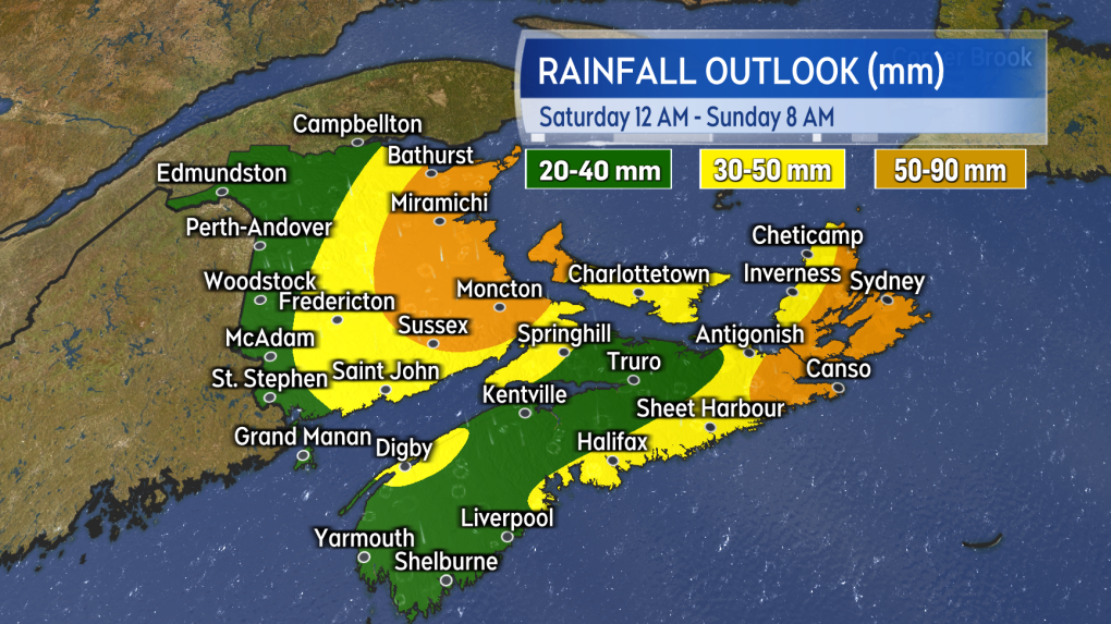
In general the storm is expected to bring 20 to 50 mm of rain to the region. Rain totals for some areas may reach 50 to 90 mm.
Given the dry conditions that prevailed through the summer and fall that rain is need in many areas.
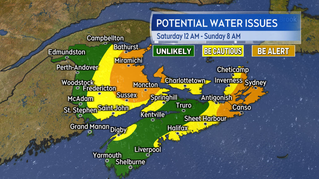
A rainfall total of 50 mm or more in 24 hours or less can be associated with water hazards such as hydroplaning conditions on roads and instances of localized flooding. Areas of central and eastern New Brunswick, eastern Nova Scotia, and Prince Edward Island look to have the highest chance of reaching that mark as of Thursday afternoon. There may still be some change in the areas expected to see the heaviest rain as the weekend approaches.
 The risk of hydroplaning conditions and localized flooding looks highest around areas of eastern and central New Brunswick and Cape Breton.
High and gusty winds
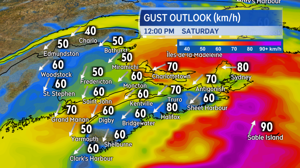
A north easterly wind will strengthen across the Maritimes Saturday morning into Saturday afternoon.
Gusts could approach the warning criteria of 90 km/h for exposed areas of the eastern coastline of New Brunswick, eastern Nova Scotia including Cape Breton, and Prince Edward Island. Due to the topography of the Highlands gusts in northern Inverness County, Cape Breton will exceed 100 km/h. Peak gusts for the remainder of the Maritimes reaching 40 to 70 km/h.
The wind will become west and northwest Saturday night into Sunday morning. Peak gusts of 50 to 70 km/h expected to persist on Sunday. The wind is expected to diminish further Sunday night into Monday morning.
The high wind may lead to sporadic utility outages in the region and may disrupt some travel services such as ferry services.
 High and gusty northeast winds develop on Saturday. The wind could approach warning criteria in eastern parts of the region.
High surf and crashing waves
The presence of low pressure in combination with high wind will increase surf around areas of the coast.
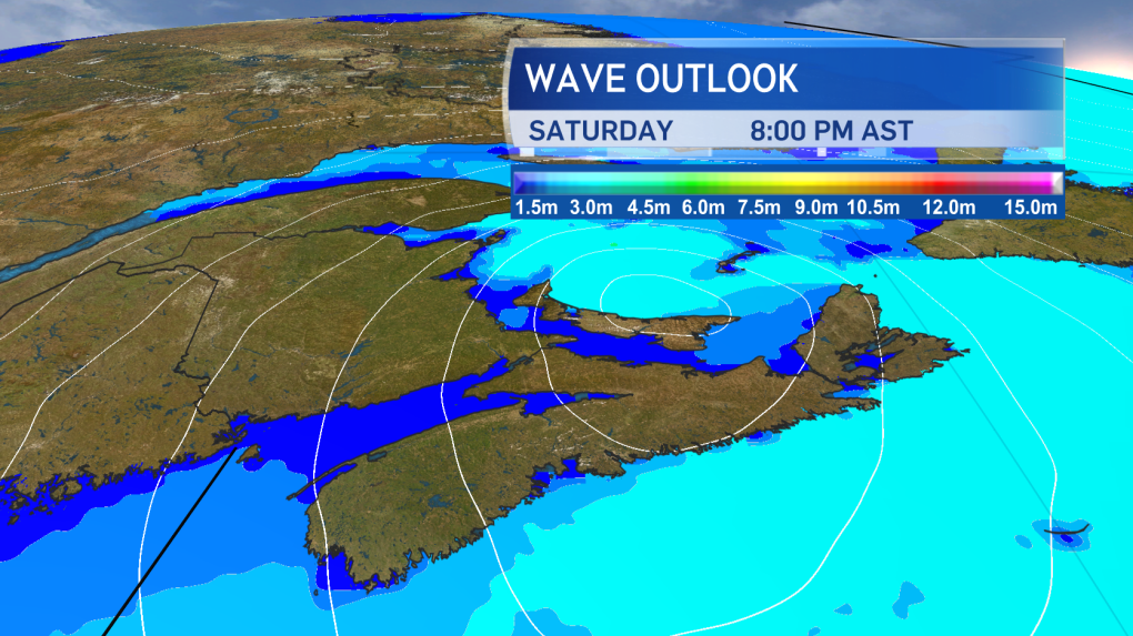
Parts of the Acadian Peninsula in New Brunswick, Atlantic coastline of Nova Scotia, and the northern coastline of Prince Edward Island could see waves of 2.5 to 4 metres (8 to 13 feet) that would then break upon approach the shoreline. That could lead to splash exceeding typical high water marks during high tides.
 Large and crashing waves will develop for coastal areas of the Maritimes by Saturday afternoon and evening.
The increased wave action is expected to continue into Sunday with the wind direction changing to become offshore which may reduce the impact on the coast.
CTVNews.ca Top Stories

Poilievre writes to GG calling for House recall, confidence vote after Singh declares he's ready to bring Liberals down
Conservative Leader Pierre Poilievre has written to Gov. Gen. Mary Simon, imploring her to 'use your authority to inform the prime minister that he must' recall the House of Commons so a non-confidence vote can be held. This move comes in light of NDP Leader Jagmeet Singh publishing a letter stating his caucus 'will vote to bring this government down' sometime in 2025.
BREAKING At least 2 dead and 68 hurt after a car drives into a German Christmas market in a suspected attack
A car plowed into a busy outdoor Christmas market in the eastern German city of Magdeburg on Friday, killing at least two people and injuring at least 68 others in what authorities suspect was an attack.
Judge sentences Quebecer convicted of triple murder who shows 'no remorse'
A Quebecer convicted in a triple murder on Montreal's South Shore has been sentenced to life in prison without chance of parole for 20 years in the second-degree death of Synthia Bussieres.
'I understand there's going to be a short runway,' new minister says after Trudeau shuffles cabinet
Prime Minister Justin Trudeau added eight Liberal MPs to his front bench and reassigned four ministers in a cabinet shuffle in Ottawa on Friday, but as soon as they were sworn-in, they faced questions about the political future of their government, and their leader.
BREAKING Fake nurse Brigitte Cleroux sentenced to 7 years in prison
A woman who illegally treated nearly 1,000 patients in British Columbia while impersonating a nurse has been sentenced to seven years in prison.
Poilievre to Trump: 'Canada will never be the 51st state'
Conservative leader Pierre Poilievre is responding to U.S. president-elect Donald Trump’s ongoing suggestions that Canada become the 51st state, saying it will 'never happen.'
Toronto officials warn of possible measles exposure at Pearson airport
Toronto Public Health (TPH) is advising of another possible measles exposure at Canada’s largest airport.
Party City closing in U.S., Canadian stores remain 'open for business'
The impending closure of all Party City locations in the United States will not extend into Canada.
Guelph man facing assault charge after police say he spat in roommate's face during disagreement over cat
A fight between roommates has led to an assault charge for a Guelph man.


