
A fall storm will bring high winds and periods of heavy rain across the Maritimes on Thursday.
The situation is fairly standard for a fall nor'easter. A developing low moving across the mid-western United States will shift its energy to the Atlantic coastline late Wednesday. As a result, an intense centre of low pressure will travel north of Cape Cod, across the Maritimes, and into the Gulf of St. Lawrence on Thursday and continuing until Friday afternoon.
The most inclement weather for the Maritimes will be experienced Thursday morning through evening. Lighter rain and still gusty winds will persist Thursday overnight into Friday. Both wind and rain are forecast to near warning criteria for parts of the region.
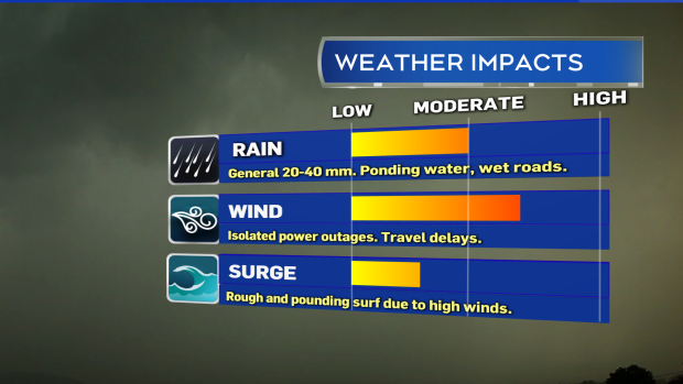
High winds will likely have the biggest impact on Thursday. Rain will be heavy at times and coastal waters will be rough.
The highest gusts will be from an easterly direction and for the Bay of Fundy coastline in New Brunswick, Nova Scotia, and Prince Edward Island. Peak gusts look likely to reach 70 to 100 km/h with the strongest occurring on exposed areas of eastward facing coasts and at higher terrain. Due to the topography of the Highlands in Cape Breton, Inverness County north of Mabou will experience gusts in excess of 100 km/h Thursday evening and night.
Given the period of strong winds, there will be a risk of isolated power outages and minor/temporary disruption to travel services such as bridges, ferries, and airports. Light objects that could become wind-blown should be secured ahead of Thursday. This would include fall/Halloween decorations.
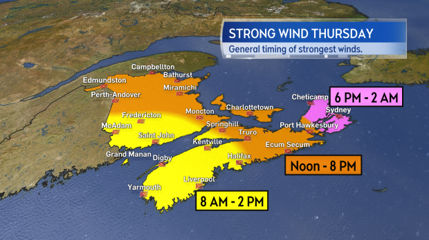
Approximate timing of the strongest gusts moving across the Maritimes on Thursday.
Rain will be heavy at times, but less likely than the wind to have significant impacts. A general 20 to 40 mm can be expected for most of the Maritimes with a risk of local amounts 40 to 60 mm, primarily for the South Shore of Nova Scotia and the southwestern corner of New Brunswick. It would be advisable to check your property drainage to ensure it isn't blocked by fall debris and don't forget that wet leaves on roads can reduce traction.
A special weather statement ahead of the storm has been issued for all three Maritime provinces advising that residents continue to check in on the forecast.


