Fiona closes in, hurricane and tropical storm warnings in effect
After passing to the west of Bermuda, Fiona regained Category 4 strength as the maximum sustained wind near the eye of the storm came up to 215 kilometres per hour.
As forecast, Fiona continues to pick up speed in a northeastward direction -- now moving at 56 kilometres per hour. As of 2:15 p.m. Friday, the centre of Fiona was about 800 kilometres due south of Halifax.
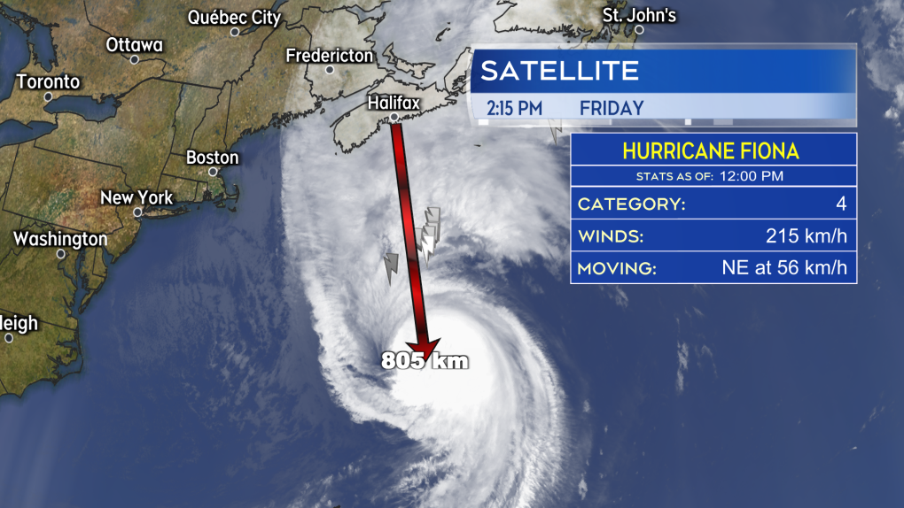 Hurricane Fiona is rapidly closing the distance towards Atlantic Canada, moving northeast at near 56 km/h.
TRACK
Very little has changed with the forecast track of Fiona over the last 24 hours. The storm is expected to enter in the Scotia Slope marine district as a Category 3 hurricane Friday evening. A landfall as a severe post-tropical storm -- equivalent to a Category 2 hurricane -- is expected in eastern Nova Scotia early Saturday morning.
It looks increasingly likely the landfall point will be somewhere between Canso on the mainland and Louisbourg in Cape Breton, occurring near 5 or 6 a.m. Saturday morning. However, some change in landfall point and time is still possible.
After landfall, the storm will slow into Saturday evening, before the centre lifts to pass north near the western coastline of Newfoundland.
The storm will have broad and severe impacts to the Maritimes when it comes to wind, rain, and storm surge. Hurricane and Tropical Storm Warnings have been issued. Weather conditions deteriorate Friday night into Saturday morning.
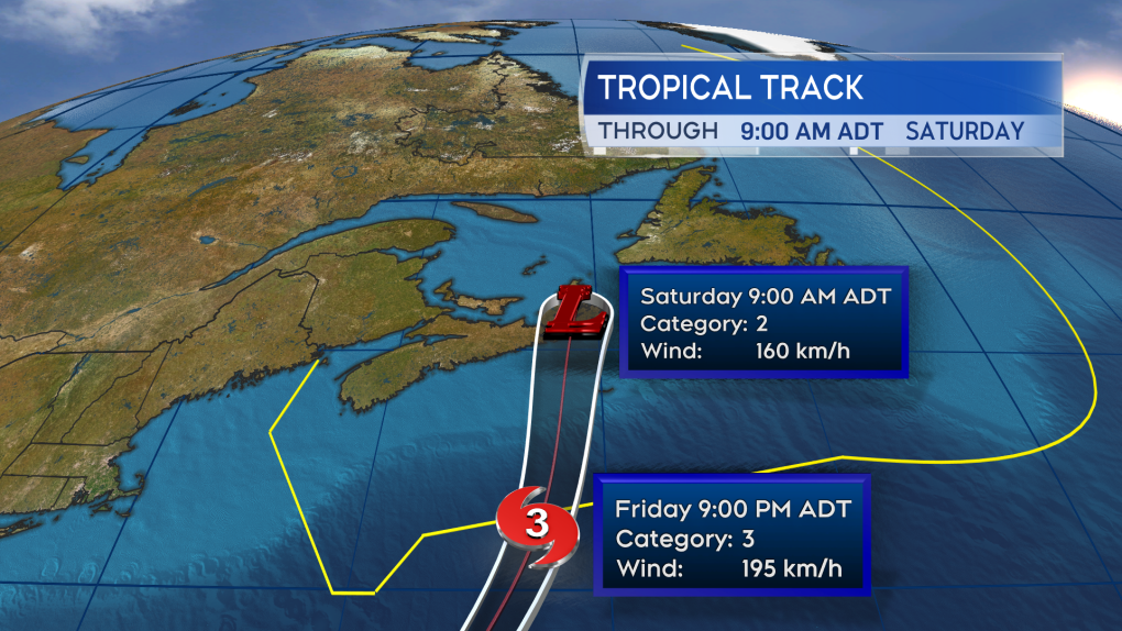 Little has changed with the forecast track of the storm over the last 24 hours. An expected landfall in eastern Nova Scotia as the equivalent of a Category 2 hurricane early Saturday morning.
WIND
The strongest wind will occur north and east of Fiona’s landfall point. This brings particularly high and dangerous winds to Cape Breton, eastern mainland Nova Scotia, the north shore of Nova Scotia, Prince Edward Island, and the southeastern coastline of New Brunswick.
In these areas, peak wind gusts could reach 120 to 150 kilometres per hour, creating a high risk of tree fall and potentially some damage to parts of structures, such as roofing material. Tropical storm force winds, which could include gusts 90 to 120 kilometres per hour, may extend much further to the west.
The remainder of Nova Scotia, the eastern half of New Brunswick, and the Bay of Fundy coastline are under a wind warning cautioning of that. Power outages are likely to occur as a result of those winds particularly as leaves are still on trees increasing the force of that wind against them. Wind will gradually diminish Saturday afternoon for western areas and Saturday evening for areas in the east.
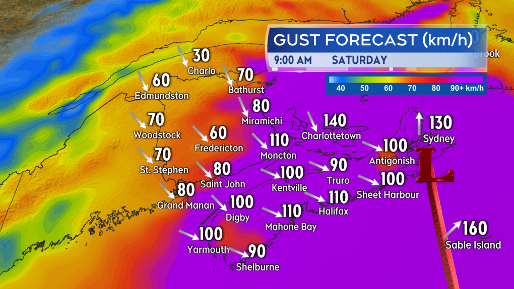 Wind becomes increasingly strong Friday night into Saturday morning for much of the Maritimes. The strongest expected in eastern Nova Scotia and P.E.I.
RAIN
Heavy rain will accompany the storm for the eastern half of the Maritimes. The highest rainfall totals, and risk of flash flooding and washouts, are in eastern P.E.I and eastern Nova Scotia where 80 to 200 millimetres is possible. Rainfall rates will increase to become torrential Friday night into Saturday morning. The pounding rain will reduce visibility and create hydroplaning conditions on roads.
The amount and impact of the rain diminishes moving west into New Brunswick, west in P.E.I., and southwest in Nova Scotia. Rainfall Warnings have been issued for a large area of the Maritimes.
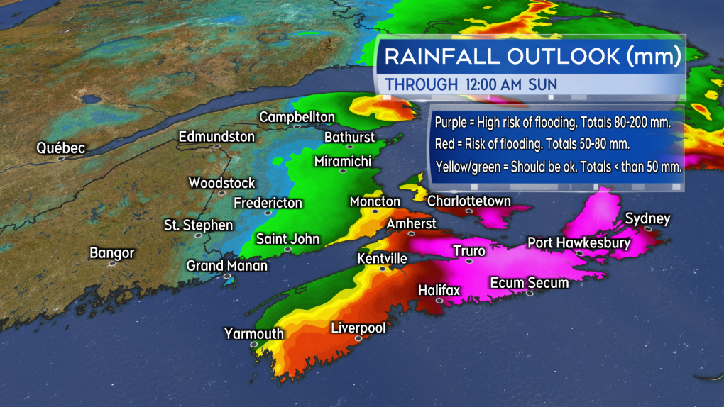 Torrential rain giving totals of 80 to 200 mm is expected in eastern Prince Edward Island and eastern Nova Scotia giving a risk of flash flooding and washouts.
STORM SURGE
Storm Surge Warnings are in effect for the eastern coastline of New Brunswick, the northern coastline of Prince Edward Island, the North Shore of Nova Scotia, Cape Breton, and coastal Guysborough County. There will be a combination of elevated water levels, high winds, and crashing waves in these areas. Risks include damage to coastal infrastructure, flooding, and erosion. Extra caution should be taken near the high tide occurring Saturday morning.
The risk of storm surge diminishes Saturday afternoon. Extremely large waves of eight to 12 metres – or 25 to 40 feet -- may be present near coastal areas of eastern Cape Breton. Those extreme waves are expected to break upon approach to shore.
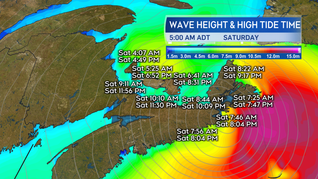 Intense wave action is expected for coastal areas of the east of the Maritimes. Extra caution should be taken at high tide Saturday morning.
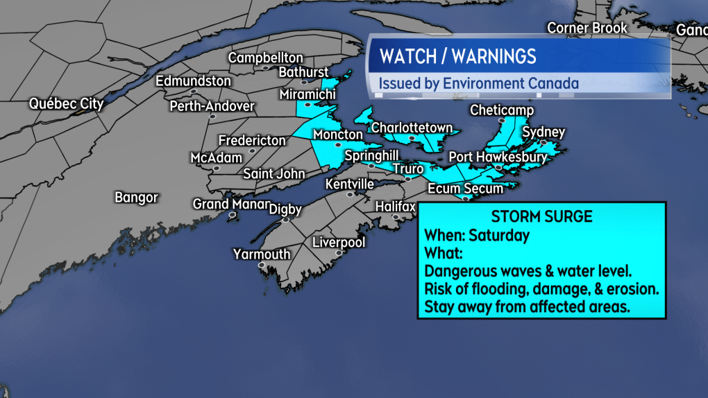 Storm surge warnings have been posted for parts of the Maritimes at greatest risk of damage, flooding, and erosion during passage of the storm.
MAGDALEN ISLANDS
The Magdalen Islands can expect similar storm impact as the northern coastline of Prince Edward Island. This includes a risk of peak wind gusts from the north of 120 to 150 kilometres per hour Saturday morning. Rainfall totalling 80 to 100 millimetres and the threat of storm surge Saturday morning until noon. The islands are under Rain, Wind, Storm Surge, and a Hurricane Warning.
STORM PASSAGE
Weather conditions gradually improve Saturday afternoon through Saturday night, west-to-east, for the Maritimes. Sunday forecast will be a mix of sun and cloud with a gusty west wind and high temperatures in the mid-to-high teens. It will likely take days to assess the damage from the storm and longer to fully recover for those areas hit hardest
CTV news will have live, comprehensive coverage in our live Fiona newscast special beginning at 6 a.m. Saturday. It can be watched on TV at CTV News, on the CTV News App, and on our website at ctvnewsatlantic.ca.
It's important residents continue checking the details of the latest weather warnings issued for their specific area.
CTVNews.ca Top Stories

opinion Tom Mulcair: Prime Minister Justin Trudeau's train wreck of a final act
In his latest column for CTVNews.ca, former NDP leader and political analyst Tom Mulcair puts a spotlight on the 'spectacular failure' of Prime Minister Justin Trudeau's final act on the political stage.
B.C. mayor gets calls from across Canada about 'crazy' plan to recruit doctors
A British Columbia community's "out-of-the-box" plan to ease its family doctor shortage by hiring physicians as city employees is sparking interest from across Canada, says Colwood Mayor Doug Kobayashi.
'There’s no support': Domestic abuse survivor shares difficulties leaving her relationship
An Edmonton woman who tried to flee an abusive relationship ended up back where she started in part due to a lack of shelter space.
opinion King Charles' Christmas: Who's in and who's out this year?
Christmas 2024 is set to be a Christmas like no other for the Royal Family, says royal commentator Afua Hagan. King Charles III has initiated the most important and significant transformation of royal Christmas celebrations in decades.
Baseball Hall of Famer Rickey Henderson dead at 65, reports say
Rickey Henderson, a Baseball Hall of Famer and Major League Baseball’s all-time stolen bases leader, is dead at 65, according to multiple reports.
Arizona third-grader saves choking friend
An Arizona third-grader is being recognized by his local fire department after saving a friend from choking.
Germans mourn the 5 killed and 200 injured in the apparent attack on a Christmas market
Germans on Saturday mourned the victims of an apparent attack in which authorities say a doctor drove into a busy outdoor Christmas market, killing five people, injuring 200 others and shaking the public’s sense of security at what would otherwise be a time of joy.
Blake Lively accuses 'It Ends With Us' director Justin Baldoni of harassment and smear campaign
Blake Lively has accused her 'It Ends With Us' director and co-star Justin Baldoni of sexual harassment on the set of the movie and a subsequent effort to “destroy' her reputation in a legal complaint.
Oysters distributed in B.C., Alberta, Ontario recalled for norovirus contamination
The Canadian Food Inspection Agency has issued a recall due to possible norovirus contamination of certain oysters distributed in British Columbia, Alberta and Ontario.


