
HALIFAX -- With high pressure to our east and low pressure to the west, the Maritime region will be put into a steady southwest flow of warm, humid air up the eastern seaboard this week.
This setup will have various impacts around the region, including significant inland/coastal temperature differences, development of coastal fog and drizzle, mild nights, some chance of thunderstorms, and, finally, a weather front breaking the pattern with widespread rain and showers late week.
Let’s start with temperatures.
A southwest flow is a generally warmer wind for us as it taps into the maritime tropical air to our south. This will help push many inland high temperatures into the mid-to-high 20s and even low 30s much of this week. That said, we do have to note that near coastal water temperatures are still only 4 to 7 degrees.
Where the southwest wind is more directly onshore, temperatures will be cooler, with highs in the low to mid-teens in some cases. This effect will be most widespread on the Atlantic coastline of Nova Scotia and the Bay of Fundy coastline. Additionally, as the more humid air cools over those waters, it is more likely that some coastal locations could get socked in by fog and drizzle. This coastal fog and drizzle is expected to start developing Monday evening.
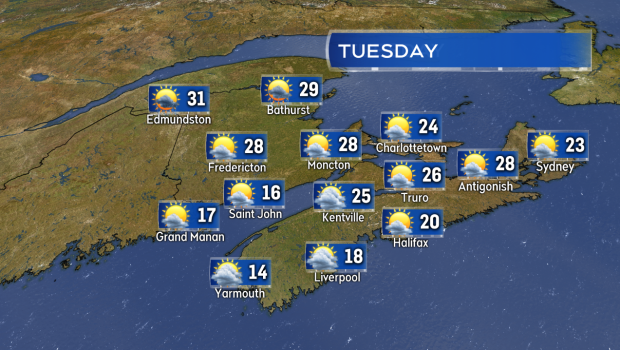
Hot and more humid by May standard Tuesday in the Maritimes, except cooler for coastal areas in directly onshore southwest winds -- notably the Atlantic coastline of Nova Scotia and Bay of Fundy coastline in New Brunswick.
The increasing humidity this week will also not allow temperatures to cool off as much during the nights. While not reaching a level that most would find uncomfortable, many nights this week will have low temperatures that remain in the low-to-mid teens.
At least we can take a risk of frost off our plate for the next several days!

Dew point temperatures are used to keep track of the level of moisture in the air. Mid-to-high teens should bring a noticeable increase in humidity. Note how that is forecast to break during the upcoming weekend.
Our air will become progressively more buoyant this week as well -- more prone to pop-up showers and possibly thunderstorms.
This starts Tuesday in New Brunswick, with a late afternoon and evening chance of showers and thunderstorms in northern areas of the province.
Western Prince Edward Island will have a slight risk of a showers or thunderstorms Tuesday night. Tuesday through Thursday, the chance of showers will remain highest in northern and central areas of New Brunswick, though the odd shower is possible in P.E.I. and Nova Scotia. Any thunderstorms with the showers will be of concern, not only because lightning can be dangerous, but because lightning strikes can ignite wildfires.
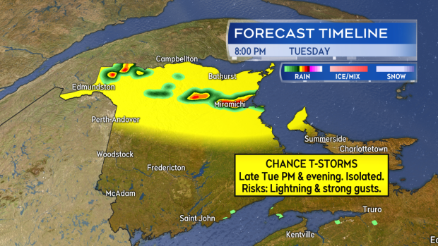
Scattered showers in northern New Brunswick Tuesday afternoon and evening will be accompanied by the risk of thunderstorms. Lightning and strong wind gusts look to be the greatest hazards with any developed storms.
The few showers and higher humidity should help gradually with the high-to-extreme Fire Weather Index across the Maritimes. Of bigger help may be the more widespread showers and rain that a cold front will bring late Friday into Saturday. That front should also bring down heat/humidity levels following passage for those who find the increase this week uncomfortable.
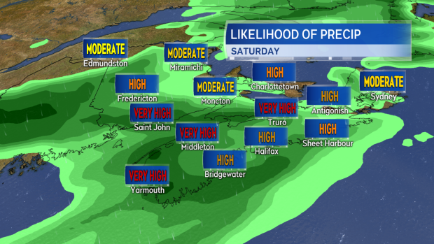
Rain and showers are forecast to become widespread late Friday into Saturday as a cold front crosses the region.
I’ll be tracking all of the above through the week with the latest updates on CTVNewsAtlantic.ca, CTV Atlantic News at Noon, 5, 6, and 11:30 p.m.


