Heat warnings expanded across the Maritimes, first named storm for hurricane season possible by Wednesday
 A father and daughter walk along a wooden bridge in Rainbow Haven Beach Provincial Park in Cow Bay, N.S. on Father's Day, Sunday, June 19, 2016. THE CANADIAN PRESS/Darren Calabrese
Environment Canada has placed the entirety of the Maritimes under heat warnings as of Tuesday afternoon.
The criteria for a heat warning is slightly different for each Maritimes province but require two consecutive days and nights of hot temperatures, high humidex and warm nights.
The warnings call for widespread humidex values making it feel well into the 30s and in some cases 40s for the Maritimes. The warnings note that some coastal areas will experience more moderate temperatures.
The weather agency goes on to recommend to “Drink plenty of water regularly, even before you feel thirsty, to decrease your risk of dehydration. Thirst is not a good indicator of dehydration. Watch for early signs of heat illness - feeling unwell, fatigue, thirst, headache - all these can rapidly evolve into life-threatening emergencies. Move to a cooler environment immediately, such as a shaded or air-conditioned space.”
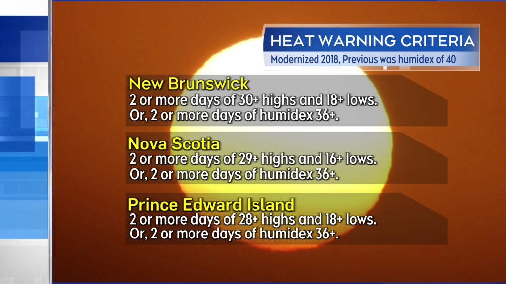 Heat warning criteria for the three Maritime provinces.
Mid-week heat
Parts of the Maritimes are experiencing the first of some unseasonably hot and humid weather Tuesday. High temperatures for much of New Brunswick and interior areas of the southwest of Nova Scotia are expected to reach temperatures in the high 20s and low 30s.
Humidex values, or what it feels like with both heat and humidity, are expected in the mid-to-high 30s.
Both the heat and humidity are expected to reach a peak in the Maritimes Wednesday and Thursday.
On Wednesday, high temperatures reach high 20s and low 30s across most of the region. Humidex values will make it feel in the mid-to-high 30s with some in New Brunswick into the low 40s. There will be cooler coastal areas, especially the Bay of Fundy coastline of New Brunswick and Atlantic coastal Nova Scotia, where the wind is expected to be more onshore.
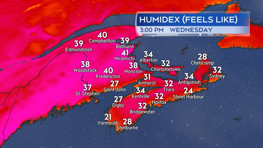 Possible humidex values, or what it feels like with both temperature and humidity, Wednesday afternoon in the Maritimes.
Similar conditions are expected on Thursday with a few exceptions. Once again, areas directly on the coast will have more moderate temperatures as a result of a breeze off the ocean. Additionally, a turn to a northwest wind in northern New Brunswick will start bringing in some slightly cooler and much less humid air. It will still be hot Thursday for northern New Brunswick, but the humidex values could be reduced to the high 20s and low 30s.
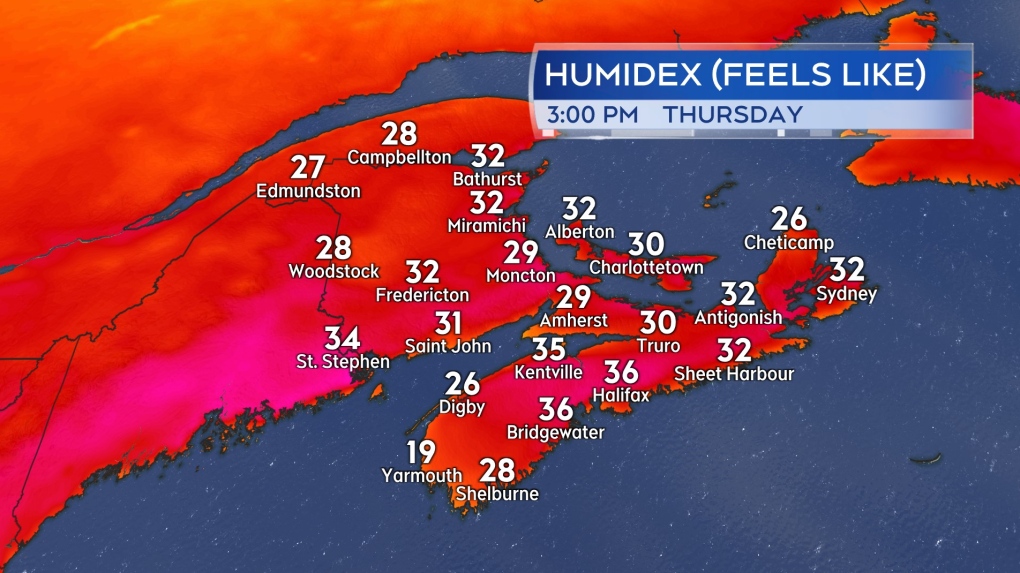 Possible humidex values, or what it feels like with both temperature and humidity, Thursday afternoon in the Maritimes.
Relief Friday into Saturday
This first round of peak summer heat and humidity doesn’t linger for an overly extended period of time. A cold front is forecast to cross the Maritimes late Thursday into early Friday. Behind the front, some much less humid air filters will arrive from the north and will work to relieve both temperature and humidity levels Friday into Saturday.
Due to the warm, humid air built up ahead of the arrival of the front, as the system moves through, it will bring a risk of thunderstorms. The chance of thunderstorms are highest Thursday afternoon and evening in New Brunswick, Prince Edward Island, and eastern Nova Scotia.
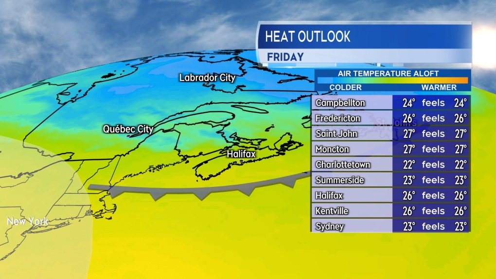 A cold front brings a risk of thunderstorms to the Maritimes Thursday. Less humid air behind the front will help to relieve the heat and humidity built up for Friday.
Possible first named storm of hurricane season
The National Hurricane Center has designated a developing system in the Gulf of Mexico as Potential Tropical Cyclone One. While not a tropical storm yet there is a high degree of confidence it will develop into one by Wednesday. If and once it does, it will be named Alberto, the first named storm of the 2024 Atlantic hurricane season.
The system is forecast to move westward coming onshore in the Mexican province of Tamaulipas Wednesday into Thursday. The system could bring areas of heavy rain to northeastern Mexico as well as parts of southern Texas. Flash flooding and mudslides in higher terrain are common hazards associated with this type of storm.
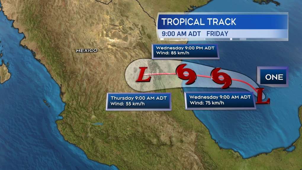 The forecast cone for Potential Tropical Cyclone One issued by the National Hurricane Center.
CTVNews.ca Top Stories

Quebec man, 81, gets prison sentence after admitting to killing wife with Alzheimer's disease
An 81-year-old Quebec man has been sentenced to prison after admitting to killing his wife with Alzheimer's disease.
Canada Post quarterly loss tops $300M as strike hits second week -- and rivals step in
Canada Post saw hundreds of millions of dollars drain out of its coffers last quarter, due largely to its dwindling share of the parcels market, while an ongoing strike continues to batter its bottom line.
'Immoral depravity': Two men convicted in case of frozen migrant family in Manitoba
A jury has found two men guilty on human smuggling charges in a case where a family from India froze to death in Manitoba while trying to walk across the Canada-U.S. border.
Prime Minister Trudeau attends Taylor Swift's Eras Tour in Toronto with family
Prime Minister Justin Trudeau is a Swiftie. His office confirmed to CTV News Toronto that he and members of his family are attending the penultimate show of Taylor Swift's 'The Eras Tour' in Toronto on Friday evening.
Trump supporters review-bomb B.C. floral shop by accident
A small business owner from B.C.'s Fraser Valley is speaking out after being review-bombed by confused supporters of U.S. president-elect Donald Trump this week.
Pat King found guilty of mischief for role in 'Freedom Convoy'
Pat King, one of the most prominent figures of the 2022 'Freedom Convoy' in Ottawa, has been found guilty on five counts including mischief and disobeying a court order.
Nearly 46,000 electric vehicles recalled in Canada over power loss risk
Nearly 46,000 electric vehicles from Kia, Hyundai and Genesis are being recalled in Canada over a potential power loss issue that can increase the risk of a crash.
Trump chooses Bessent to be Treasury secretary and Vought as top budget official
President-elect Donald Trump announced Friday that he'll nominate hedge fund manager Scott Bessent, an advocate for deficit reduction, to serve as his next treasury secretary. Trump also said he would nominate Russel Vought to lead the Office of Management and Budget.
Canada's tax relief plan: Who gets a cheque?
The Canadian government has unveiled its plans for a sweeping GST/HST pause on select items during the holiday period. The day after the announcement, questions remain on how the whole thing will work.


