Hurricane Fiona intensifies, alerts issued in Atlantic Canada
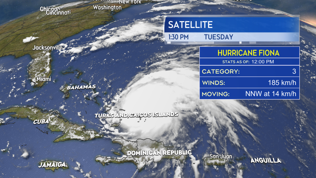
Hurricane Fiona intensified rapidly from a Category 1 to a Category 3 hurricane as it moved towards the Turks and Caicos Islands Monday afternoon into Tuesday morning, with maximum sustained winds near the eye of 185 kilometres per hour.
 Hurricane Fiona is currently a Category 3 hurricane bringing hurricane conditions to parts of the Turks and Caicos Islands as it continues to move northward.
TRACK
The hurricane is forecast to move north into an area of favourable ocean water temperatures and atmospheric conditions allowing it to become a Category 4 hurricane, with maximum sustained winds near 220 kilometres per hour as it passes west of Bermuda late Thursday. While a direct hit to Bermuda is not forecast, the Island is still being advised to monitor the progress of the hurricane.
The National Hurricane Center then brings Fiona as a Category 3 hurricane into the Scotia Slopes marine area south of Sable Island Friday night. Fiona is then forecast to approach eastern Nova Scotia as a Category 2 hurricane Saturday morning.
The forecast cone -- or the area the centre of the storm is expected to take a path through -- still encompasses a large area of Atlantic Canada, stretching from Halifax on the western side, to the Burin Peninsula in Newfoundland on the eastern side. The cone does not predict the entirety of the area to be impacted by the storm nor the intensity of those impacts.
 Hurricane Fiona is forecast to enter the Atlantic Canada region as a Category 2 hurricane transitioning to a powerful post-tropical storm late Friday into Saturday.
POST-TROPICAL TRANSITION
Regardless of the approach intensity and track of the hurricane, it is expected to undergo a post-tropical transition as it passes through Atlantic Canada.
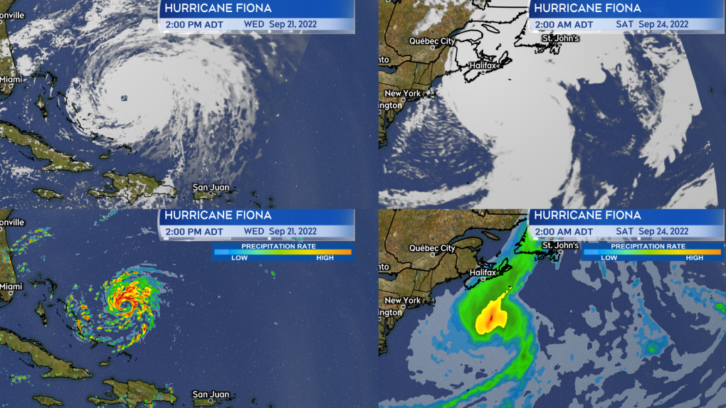
This starts as the hurricane interacts with a weather front (cold front) on Friday and continues into the weekend. There will be a number of changes to the storm as a result including:
- An increase in speed northwards. Fiona will cover as much or more distance between Friday morning and Saturday as it will between Tuesday morning and Friday morning.
- An increase in the size of the storm. Fiona will take on a more stretched, asymmetrical appearance and cover a larger area.
- The intensity of rain and wind diffuses away from the centre of the storm but impacts a broader area. This means that heavy rain and high winds may be experienced further out from the centre of Fiona.
 As Hurricane Fiona undergoes post-tropical transition it will go from symmetrical with intense conditions near the centre (left) to asymmetrical, larger and with more diffused rain and wind (right).”>
ALERTS ISSUED
Environment Canada and the Canadian Hurricane Centre posted a Tropical Cyclone Information Statement for Newfoundland, Prince Edward Island, eastern New Brunswick, and all but the southwest of Nova Scotia Tuesday morning. They state that they are monitoring the hurricane, that the storm will become quite large and impact a broad area, and that the Canadian Hurricane Centre will begin six-hourly bulletin updates Tuesday night or early Wednesday.
 An initial tropical weather statement was issued by the Canadian Hurricane Centre Tuesday morning.
THE MARITIMES
While this storm will be large with broad impacts, we still need to narrow down the approach it will take through the region. A move towards Newfoundland will lessen the intensity of the impacts for the Maritimes, while a pass near or through Cape Breton would increase them. That will be narrowed considerably over the next few days.
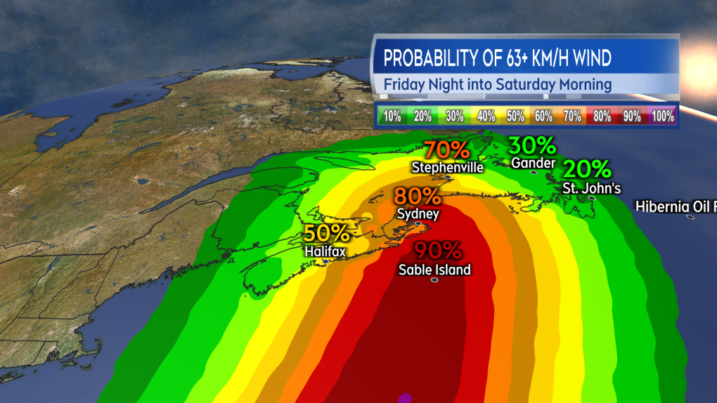
The National Hurricane Center is giving a moderate-to-high probability of eastern P.E.I. and eastern Nova Scotia getting into tropical storm force winds (one minute sustained wind of 63+ kilometres per hour, stronger gusts) Friday night into Saturday morning. That said, the entirety of the Maritimes should be checking in on the forecast for the storm daily.
Some initial preparation for a high wind, heavy rain event would be appropriate. Things like checking working condition of generators and sump pumps, and making sure property drainage is free and clear of debris.
 The probability of eastern parts of the Maritimes experiencing tropical storm force winds Friday night into Saturday has increased.
CTVNews.ca Top Stories

Southern California wildfire destroys many structures; governor declares state of emergency
A wildfire whipped up by extreme winds swept through a Los Angeles hillside dotted with celebrity residences Tuesday, burning homes and forcing the evacuation of tens of thousands of people.
Trump is open to using 'economic force' to acquire Canada; Trudeau responds
Prime Minister Justin Trudeau said 'there isn’t a snowball’s chance in hell that Canada would become part of the United States,' on the same day U.S. president-elect Donald Trump declared that he’s open to using 'economic force' to acquire Canada.
A B.C. mom's real-life nightmare and the search to find her trafficked daughter
A Vancouver island mom shares the story of what happened to her teenaged daughter – and a warning for other parents about sex trafficking.
Liberal leadership hopeful Frank Baylis noncommittal on eliminating consumer carbon tax
Liberal leadership hopeful Frank Baylis says eliminating the consumer carbon tax alone will not 'solve the affordability issue for Canadians.'
Canadian naval vessel shadowed by Chinese war ship in the East China Sea
CTV National News is on board the HMCS Ottawa, embedded with Canadian Navy personnel and currently documenting their work in the East China Sea – a region where China is increasingly flexing its maritime muscle. This is the first of a series of dispatches from the ship.
Patient dies in waiting room at Winnipeg hospital
An investigation is underway after a patient waiting for care died in the waiting room at a Winnipeg hospital Tuesday morning.
Limit coffee-drinking to this time window to lower early death risk, study suggests
Drinking coffee has repeatedly been linked with better heart health and prolonged life. But the benefits of coffee consumption could depend on when you drink it, new research has found.
B.C. 'childbirth activist' charged with manslaughter after newborn's death
A British Columbia woman who was under investigation for offering unauthorized midwifery services is now charged with manslaughter following the death of a newborn baby early last year.
Man who exploded Tesla Cybertruck outside Trump hotel in Las Vegas used generative AI, police say
The highly decorated soldier who exploded a Tesla Cybertruck outside the Trump hotel in Las Vegas used generative AI including ChatGPT to help plan the attack, Las Vegas police said Tuesday.


