Hurricane watches issued ahead of weekend arrival of Fiona
A series of hurricane and tropical storm watches were issued for Atlantic Canada by Environment Canada and the Canadian Hurricane Centre Thursday afternoon. A watch means that hurricane or tropical storm conditions are possible in the alerted area within 36 hours.
TRACK
Hurricane Fiona continues to pick up speed towards the north as a Category 4 hurricane, now moving at nearly 25 kilometres per hour. The storm is forecast to pass to the west of Bermuda and enter the Scotian Slope marine waters of Atlantic Canada as a Category 3 hurricane on Friday.
Landfall as a powerful post-tropical storm, equivalent to a Category 1 or 2 hurricane looks increasingly likely in eastern Nova Scotia Saturday morning. The forecast cone for that landfall has now narrowed to span eastern Halifax County across Cape Breton. Various computer models show a landfall somewhere in the area from Canso to near Louisbourg in Nova Scotia between 6 a.m. and 10 a.m. Saturday. Weather conditions in the Maritimes will deteriorate Friday night into Saturday morning.
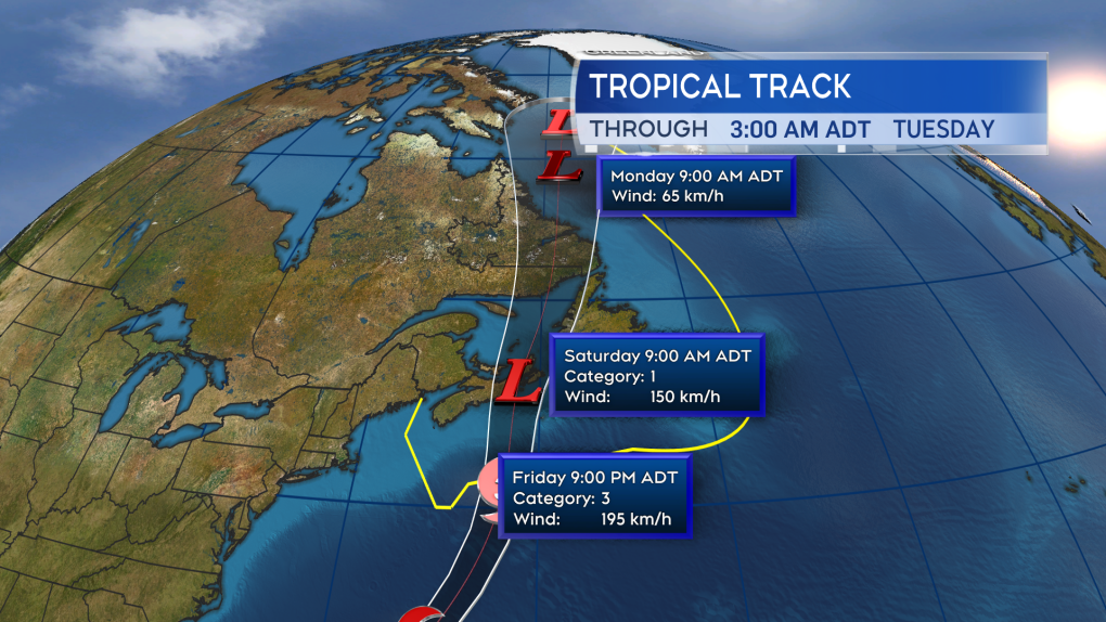 Fiona is expected to enter Canadian waters as a Category 3 hurricane late Friday. Becoming a power post-tropical storm as it makes landfall in eastern Nova Scotia Saturday morning.
HURRICANE WATCH ISSUED
A hurricane watch has been posted for Prince Edward Island and Halifax -- east across Nova Scotia. Tropical storm watches extend into the southwest of Nova Scotia and eastern New Brunswick.
The highest probabilities of hurricane force winds -- a one-minute sustained wind of 119 kilometres per hour or more -- are near and to the east of the expected landfall point. At this time, that includes parts of Guysborough and Antigonish counties on the mainland of Nova Scotia, as well as Cape Breton. Tropical storm force winds -- a one-minute sustained wind of 63 kilometres per hour -- are being given a high probability across P.E.I. and Halifax – in eastern Nova Scotia.
A moderate probability of a tropical storm force wind extends into the south shore of Nova Scotia and southeastern New Brunswick. Gust strength will exceed those one-minute sustained winds.
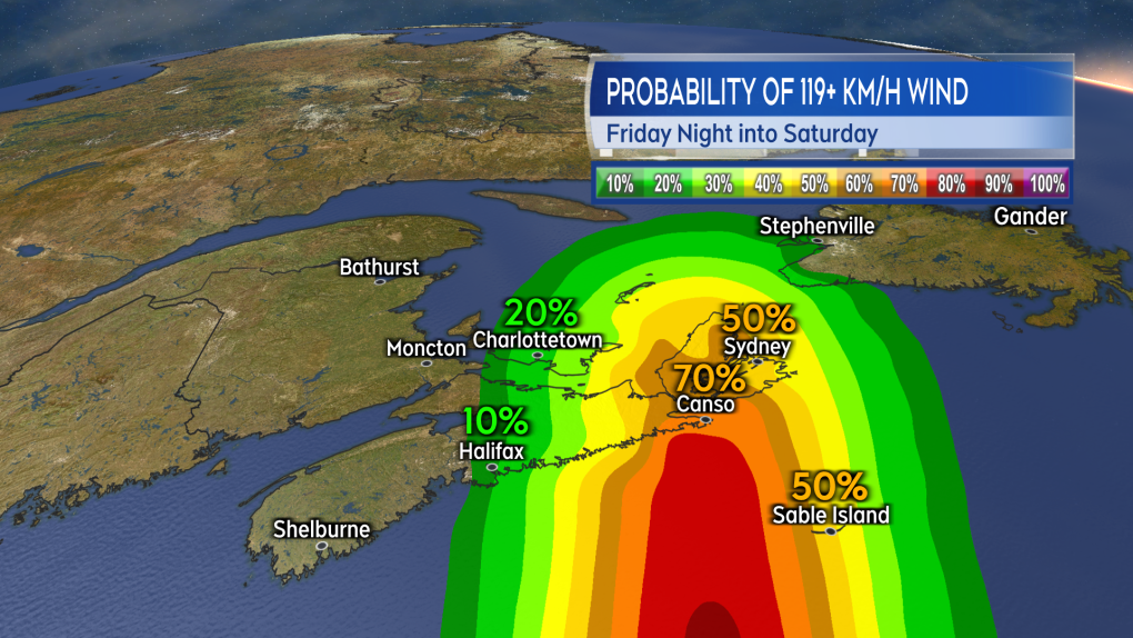 The highest probability of a hurricane force wind will be near and to the east of the landfall point. Currently looking most likely to be in eastern Nova Scotia.
 The risk of tropical storm force winds extends across much of Nova Scotia, Prince Edward Island, and into southeastern New Brunswick. That is a one minute sustained wind near 63 km/h with gusts possibly reach 100 km/h or higher.
WIND
Wind will increase in strength for much of the Maritimes Friday night into Saturday morning.
Peak gusts in eastern Nova Scotia and P.E.I. could reach 120 to 150 kilometres per hour due to being in proximity to the centre of the storm as it passes. That said, widespread gusts reaching 90 to 120 kilomtres per hours look possible, extending as far west as Halifax in Nova Scotia.
Gusts reaching 70 to 90 kilometres per hour could possibly extend into the southwest of Nova Scotia and eastern New Brunswick. Wind direction will primarily be out of the north and northwest. The exception is the area east of the landfall point, most likely Cape Breton, where the direction will be easterly turning southerly.
Wind of that strength will have the potential to cause power outages. In the eastern part of the region, where the wind is forecast to be strongest, there is an increased risk of tree and branch falls. Where the wind is onshore, it will help to produce a ferocious surf and risk of storm surge.
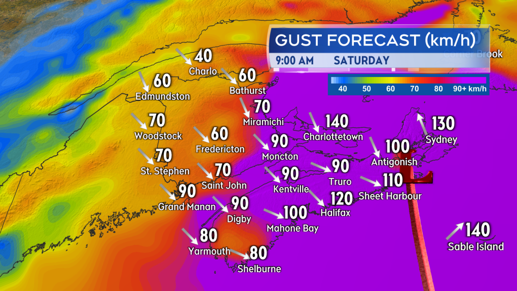 The strongest wind gusts look increasingly likely for eastern Nova Scotia and Prince Edward Island.
STORM SURGE
The greatest risk of a damaging storm surge looks to be the eastern and northern coastlines of Nova Scotia, the southeastern coastline of New Brunswick, and the northern coastline of P.E.I. The very low barometric pressure in the centre of the storm will allow for ocean water to rise up under it.
Intense winds will increase wave action against the coast further increasing the risk of flooding or damage. Near coastal waves reaching 10 metres, or 30 feet, may be present on the eastern shore of Nova Scotia late Friday night into Saturday morning.
A significant build of wave height in the Gulf of St. Lawrence is also expected, increasing the risk of erosion on north facing beaches of P.E.I. There is a period of high tide for the eastern part of the Maritimes Saturday morning -- particular caution should be taken during that tide. Waves and risk of storm surge should diminish moving through Saturday afternoon into Saturday evening.
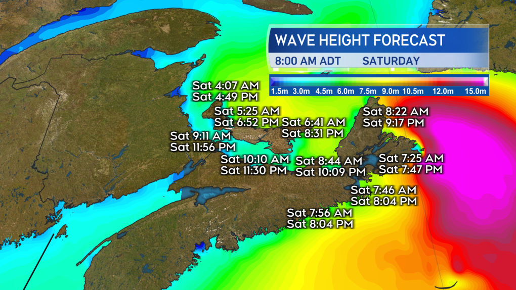 The risk of a damaging storm surge is highest in the east of the Maritimes. Extra caution should be taken if by the coast in that area particularly during the high tide Saturday morning.
RAINFALL
Torrential rain is expected for eastern parts of the Maritimes Friday night into Saturday morning. Friday through Saturday could see rain totals of 80 to 200 millimetres in eastern P.E.I. and eastern Nova Scotia increasing the risk of flash flooding and washouts. Rainfall totals could reach 50 to 80 millimetres extending towards the west of P.E.I. and central areas of Nova Scotia. There is potential for heavy rainfalls to quickly move into New Brunswick and the southwest of Nova Scotia.
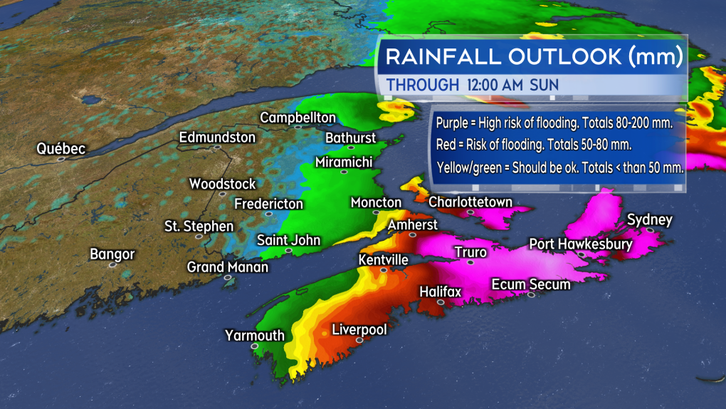 The risk of flooding is expected to be highest in eastern Prince Edward Island and eastern Nova Scotia. Rain in that part of the Maritimes could total 80 to 200 mm Friday through Saturday.
PREPARATIONS
Maritimers who have them should make sure that sump pumps and generators are in working order and the drainage on their property is clear of debris.
Other storm preparations to take include:
- having batteries for use in flashlights and lamps
- making sure mobile devices are charged
- stocking up on food and medication to last a period of 72 hours
- not travelling during the passage of the storm and the worst of the inclement weather


CTVNews.ca Top Stories

Doctors ask Liberal government to reconsider capital gains tax change
The Canadian Medical Association is asking the federal government to reconsider its proposed changes to capital gains taxation, arguing it will affect doctors' retirement savings.
Keeping these exotic pets is 'cruel' and 'dangerous,' Canadian animal advocates say
Canadian pet owners are finding companionship beyond dogs and cats. Tigers, alligators, scorpions and tarantulas are among some of the exotic pets they are keeping in private homes, which pose risks to public safety and animal welfare, advocates say.
Prince William and wife Kate thank public for birthday messages for son Louis
Prince William and his wife Kate thanked the public for their messages which had been sent to mark the sixth birthday of their youngest son Louis on Tuesday.
She was the closest she'd ever been to meeting her biological father. Then life dealt her a blow
Anne Marie Cavner was the closest she'd ever been to meeting her biological father, but then life dealt her a blow. From an unexpected loss to a host of new relationships, a DNA test changed her life, and she doesn't regret a thing.
How quietly promised law changes in the 2024 federal budget could impact your day-to-day life
The 2024 federal budget released last week includes numerous big spending promises that have garnered headlines. But, tucked into the 416-page document are also series of smaller items, such as promising to amend the law regarding infant formula and to force banks to label government rebates, that you may have missed.
Which foods have the most plastics? You may be surprised
'How much plastic will you have for dinner, sir? And you, ma'am?' While that may seem like a line from a satirical skit on Saturday Night Live, research is showing it's much too close to reality.
'Catch-and-kill' strategy to be a focus as testimony resumes in Trump hush money case
A veteran tabloid publisher was expected to return to the witness stand Tuesday in Donald Trump's historic hush money trial.
Quebec farmers have been protesting since December. Is anyone listening?
Upset about high interest rates, growing paperwork and heavy regulatory burdens, protesting farmers have become a familiar sight across Quebec since December.
South Korean sentenced to 14 months in jail for killing 76 cats
South Korean man has been sentenced to 14 months in prison for killing 76 cats in one of the country's most gruesome cases of animal cruelty in recent years.
Shopping Trends
The Shopping Trends team is independent of the journalists at CTV News. We may earn a commission when you use our links to shop. Read about us.


Toronto
-

Less than half of Canadians say they will buy an electric vehicle as their next car: survey
A recent survey shows not all Canadians are ready to make the switch to an electric vehicle as they have concerns about charging stations, cold weather and battery life.
-
Multi-vehicle crash in Durham Region shuts down ramps to Hwy. 407: police
A multi-vehicle crash in Durham region on Tuesday morning has closed ramps onto Highway 407, police say.
-
Matthews scores winner in the third, Maple Leafs down Bruins 3-2 to even series 1-1
Auston Matthews scored the winner in the third period and added two assists as the Toronto Maple Leafs topped the Boston Bruins 3-2 on Monday to even their first-round playoff series 1-1.
Calgary
-

Residential school survivor leads class-action lawsuit against Catholic Church, priest
Monday, a judge ruled a proposed class-action lawsuit can go forward despite efforts from lawyers representing the archdiocese of Edmonton and a religious order to have it struck down.
-
Suspect in deadly Calgary shooting has 'Edmonton ties': police
Calgary police have released a photo of a man wanted after a deadly shooting in the community of Shawnessy last month.
-
Calgarians to weigh in on rezoning during largest hearing in city history
The largest public hearing in the city’s history is set to get underway Monday morning.
Edmonton
-

Fire engulfs old Edmonton municipal airport hangar
A historical hangar at the former Edmonton municipal airport beside the NAIT main campus was on fire Monday night.
-
Wildfire leads to evacuation order issued for northeast Alberta community
An evacuation order was issued on Monday afternoon for homes in the area of Cold Lake First Nation.
-
Hyman, McDavid lead Oilers to 7-4 playoff win over Kings
For once the Edmonton Oilers won’t have to dig themselves out of a hole to start the NHL playoffs.
Montreal
-

Five more Quebec hospitals to offer at-home care services
Over the next few months, Quebec is expected to roll out home care services in five hospitals as part of a measure to allow patients to receive treatment at home while under the supervision of a medical team.
-
4 vehicles set ablaze in Montreal garage parking lot
Montreal police are investigating after four vehicles were set on fire Monday night.
-
Quebec farmers have been protesting since December. Is anyone listening?
Upset about high interest rates, growing paperwork and heavy regulatory burdens, protesting farmers have become a familiar sight across Quebec since December.
Ottawa
-

3 children injured after truck and school bus collide in Russell, Ont.
Three children and a driver were taken to hospital after a school bus and a truck collided on Route 400 in Russell, Ont.
-
NEW THIS MORNING
NEW THIS MORNING Pembroke, Ont. hospital anticipating doctor shortages this spring and summer
The Pembroke Regional Hospital says it is expecting longer wait times this spring and summer because of anticipated physician shortages.
-
81-year-old man seriously injured in Gatineau, Que. stabbing
An 81-year-old man is being treated for serious injuries following a daytime stabbing near a seniors' residence in Gatineau, Que.
London
-

Car fire on Highway 401 sends one person to hospital
The Dutton/Dunwich Fire Department responded to the scene near mile marker 142 between Currie Road and Iona Road, after the vehicle caught fire.
-
Byron’s colony of rare bank swallows facing new threat
Council is be urged to ensure that a plan to redevelop the Byron Gravel Pit also maintains a summer home for its long-time residents — a colony of bank swallows.
-
Missing Clinton man with Down syndrome found by 'Project Lifesaver'
Brian Gray-Hicks likes to be active, and goes for daily walks near his home in Clinton.
Barrie
-
The man who gave us 'Carefree Highway' has a street of his own
Orillia council authorized a bylaw to rename Centennial Drive Lightfoot Drive at its meeting on Monday.
-
Federal offender frequents Barrie, Midland, Thunder Bay areas: R.O.P.E. Squad
Repeat Offender Parole Enforcement (R.O.P.E.) Squad requesting the public's help in locating a federal offender.
-
Midland police net knives in routine stop
A routine patrol in Midland turned up an illegal driver and several prohibited knives.
Northern Ontario
-

Mobility scooter burst into flames in northern Ontario
It was a scary sight in northern Ontario Monday morning after an electric mobility scooter caught on fire.
-
Man responsible for northern Ont. crash that killed woman days before her wedding fined $5K
It was a sad scene at Tom Davies Square in Sudbury on Monday morning, where a man was being sentenced for a crash that killed a North Bay woman who was driving to her wedding shower.
-
Inspection blitz takes 130 CMVs off the road, northern Ont. police say
Hundreds of drivers were charged in a recent three-day commercial motor vehicle blitz conducted by the Ontario Provincial Police and Ministry of Transportation.
Kitchener
-

Serious collision in Kitchener leads to critical injuries
Ornge Air Ambulance says one person has critical injuries after a serious crash in the area of Fischer Hallman Road and Victoria Street South in Kitchener.
-
Man knows who has stolen laptop but can't get it back
A Kitchener man who forgot his laptop on a bus in January says he’s now being asked to pay $750 to get it back from whoever has the device.
-
Suspect in Brantford double shooting knocked on stranger’s door to turn himself in
Brantford police say one person remains in critical condition after a shooting in Brantford Sunday night.
Windsor
-

No injuries after multi-vehicle crash on residential street in Windsor
Just before 5 a.m., police were called to the scene of the multi-vehicle crash between on Bruce Avenue between Giles Boulevard and Clinton Street.
-
Car fire on Highway 401 sends one person to hospital
The Dutton/Dunwich Fire Department responded to the scene near mile marker 142 between Currie Road and Iona Road, after the vehicle caught fire.
-
Ont. man, 81, meets his 57-year-old son for the first time after Swedish man's decades-long search
As a young man, Jim Oran's life took unexpected turns, ultimately leading him to Sweden, where he encountered a woman who would later give birth to a child he never knew existed.
Winnipeg
-

'Never seen this before': Homes in Manitoba community damaged by ice wall
Homeowners in a Manitoba community are cleaning up after being impacted by a natural phenomenon last week.
-
'It's bittersweet': Popular St. Boniface restaurant set to close its doors
Marion Street Eatery is set to close its doors for good after over a decade serving up steaming plates of eggs benedict, grilled cheese and brisket hash.
-
Manitoba could soon end ban of growing recreational cannabis at home
People in Manitoba could soon be able to grow recreational cannabis in their homes.
Regina
-

One year after fatal collision, Regina council has final say on lower speed limit in Cathedral
Regina city councillors are set to consider lowering the speed limit in the Cathedral neighbourhood to 30 kilometres per hour on Wednesday.
-
Sask. NDP leader combats claims of carbon tax support following Ottawa visit
Members of the Sask. Party claim a recent trip by the leader of the opposition reveals her party's secret support for the federal carbon tax.
-
Sask. NDP call for education minister's firing, premier reconfirms confidence
The Saskatchewan NDP are calling for the resignation or firing of Education Minister Jeremy Cockrill, saying he lied about apologizing for comments he made to a mother whose daughter died.
Saskatoon
-

Sask. broker says halal mortgages are not a new concept in Canada
A Saskatoon mortgage broker says the federal government’s move to help Muslim Canadians get into the housing market by promoting halal mortgages is not such a radical idea — it’s helping families buy their first home without breaking their faith.
-
Sask. driver caught using vice grips in place of steering wheel
A driver caught using vice grips in place of a steering wheel was ticketed Wednesday after being stopped by police on a rural road.
-
Saskatchewan Rush look to 'better mentality next year' as they miss playoffs again
The Saskatchewan Rush are absent from the National Lacrosse League playoffs for a third straight season, a difficult end to an postseason push born out of a rocky start.
Vancouver
-

More than firefighters: B.C. chief urges home preparation for wildfire season
As the wildfire season ramps up and a pair of evacuation alerts are now in place, one of British Columbia’s top fire officials is making a personal appeal to the public to take some simple steps that could safeguard their homes.
-
Mystery surrounds giant custom Canucks jerseys worn by Lions Gate Bridge statues
The giant stone statues guarding the Lions Gate Bridge have been dressed in custom Vancouver Canucks jerseys as the NHL playoffs get underway.
-
Calls grow louder for changes to decriminalization in B.C.
Backlash to decriminalization dominated question period Monday in the B.C. legislature, with the Official Opposition BC United and BC Conservatives calling for the province to end the three-year pilot project.
Vancouver Island
-

Police release details about suspect vehicle after fatal B.C. hit-and-run crash
Mounties searching for a driver who struck and killed a woman on Vancouver Island last week released new details about the suspect vehicle Monday.
-
Search for missing kayakers off Vancouver Island expands into U.S.
Authorities on both sides of the Canada-U.S. border resumed search efforts Monday to find two men who went missing while kayaking off Vancouver Island over the weekend.
-
'Historic' law recognizing Haida Aboriginal title introduced in B.C. legislature
The B.C. government says legislation formally recognizing the Haida Nation's Aboriginal title over Haida Gwaii was introduced in the legislature Monday.
Kelowna
-
Homicide investigation underway after body found near Kelowna, B.C.
Major crime detectives in British Columbia are investigating a suspected homicide after a body was found in a remote area southeast Kelowna over the weekend.
-
Stolen snake named Milkshake returned to Kelowna pet store
A banana ball python that was stolen from a Kelowna pet store on Saturday has been returned unharmed, Mounties said.
-
Nurses rally at B.C. Interior hospital over security, staffing concerns
Nurses held a rally Wednesday at a hospital in the B.C. Interior that closed its emergency department more than a dozen times last year due to insufficient staff.


