Kalin's call: Heavy rain forecast shifts west for the Maritimes
 A woman walks in the rain in San Francisco in this file photo. (Jeff Chiu/AP)
HALIFAX -
Rain and downpours are still in the forecast for the Maritimes Thursday into Friday as the remnants of Ida come through.
The track of the system is now looking more likely to move up from Cape Cod and into the Bay of Fundy on Thursday. Then cross Prince Edward Island and move into the Gulf of St. Lawrence Thursday night into early Friday morning.
The heaviest rain is most likely near and just to the north of that path. That would give the Fundy coastline of Nova Scotia, as well as Cumberland County, southern New Brunswick and Prince Edward Island the highest risk of seeing rainfall totals that could exceed 75, or even 100 mm.
Parts of western Nova Scotia and much of eastern New Brunswick could also finish with rain totals near or in excess of 50 mm. Rainfall now forecasts lower for areas of eastern Nova Scotia and remains lower in the forecast for northwestern New Brunswick.
 The axis of heaviest rain looks to run through the Bay of Fundy, southern New Brunswick, and across P.E.I. A large portion of the Maritime region has an expected rainfall of 25 to 50+ mm.
Given the amount of rain expected for many in a span of about 24 hours, localized flooding and flash flooding is a risk. Individuals should check that drainage on and around your property is free of debris and ensure your sump pump is in working order if you have previously required use of one during a heavy rainfall.
Timing of the rain has it starting in the southwest of New Brunswick and Nova Scotia as early as 4 a.m. to 6 a.m. on Thursday. For driving considerations, the risk of downpours generally increases by Thursday noon and extends into Thursday evening and night.
Downpours should clear northeast of the region by Friday at 6 a.m., with further periods of rain for eastern New Brunswick and P.E.I. on Friday. Showers for Nova Scotia are expected on Friday.
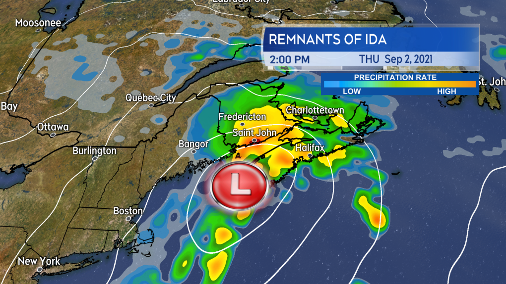
The risk of downpours, represented here by the yellow and orange colours, increases for the region Thursday afternoon into evening and night.
East and southeast winds will increase through the day on Thursday to peak with gusts of 30 to 60 km/h by late afternoon. Due to the topography of the Highlands northern Inverness County, Cape Breton could experience gusts in excess of 80 km/h Thursday evening into early Friday morning.
Wind turns west and northwest behind the low on Friday. Gusts on Friday will be generally 30 to 60 km/h but could reach 70 km/h for P.E.I. and eastern Nova Scotia especially at the coast and higher terrain.

Wind increases through the day on Thursday to peak with gusts 30 to 60 km/h for most. The wind then shifts west and northwest for Friday with similar or slightly stronger wind gusts.


CTVNews.ca Top Stories

BREAKING
BREAKING Bob Cole, veteran CBC broadcaster and former voice of 'Hockey Night in Canada,' dead at 90
Bob Cole, legendary CBC broadcaster and former voice of Hockey Night in Canada, has died. He was 90.
Harvey Weinstein's 2020 rape conviction overturned by N.Y. appeals court
New York's highest court on Thursday overturned Harvey Weinstein's 2020 rape conviction, reversing a landmark ruling of the #MeToo era in determining the trial judge improperly allowed women to testify about allegations against the ex-movie mogul that weren't part of the case.
BREAKING
BREAKING Honda to get up to $5B in govt help for EV battery, assembly plants
Honda is set to build an electric vehicle battery plant next to its Alliston, Ont., assembly plant, which it is retooling to produce fully electric vehicles, all part of a $15-billion project that is expected to include up to $5 billion in public money.
MPP Sarah Jama asked to leave Ontario legislature for wearing keffiyeh
MPP Sarah Jama was asked to leave the Legislative Assembly of Ontario by House Speaker Ted Arnott on Thursday for wearing a keffiyeh, a garment that is banned at Queen’s Park.
CTE: Researchers believe widespread brain injury may contribute to veteran suicide rate
Researchers are working to better understand if some Canadian military veterans may be suffering from Chronic Traumatic Encephalopathy, also known as CTE -- a disorder previously found in the brains of professional football and hockey players after their death.
1 arrested in northern Alberta during public shelter order
Residents of John D'Or Prairie, a community on the Little Red River Cree Nation in northern Alberta, were told to take shelter Thursday morning during a police operation.
Secret $70M Lotto Max winners break their silence
During a special winner celebration near their hometown, Doug and Enid shared the story of how they discovered they were holding a Lotto Max ticket worth $70 million and how they kept this huge secret for so long.
Remains from a mother-daughter cold case were found nearly 24 years later, after a deathbed confession from the suspect
A West Virginia father is getting some sense of closure after authorities found the remains of his young daughter and her mother following a deathbed confession from the man believed to have fatally shot them nearly two decades ago.
New deep-water channel allows first ship to pass Key bridge wreckage in Baltimore
The first cargo ship passed through a newly opened deep-water channel in Baltimore on Thursday after being stuck in the harbor since the Francis Scott Key Bridge collapsed four weeks ago, halting most maritime traffic through the city's port.
Shopping Trends
The Shopping Trends team is independent of the journalists at CTV News. We may earn a commission when you use our links to shop. Read about us.


Toronto
-
 BREAKING
BREAKING Honda to get up to $5B in govt help for EV battery, assembly plants
Honda is set to build an electric vehicle battery plant next to its Alliston, Ont., assembly plant, which it is retooling to produce fully electric vehicles, all part of a $15-billion project that is expected to include up to $5 billion in public money.
-
MPP Sarah Jama asked to leave Ontario legislature for wearing keffiyeh
MPP Sarah Jama was asked to leave the Legislative Assembly of Ontario by House Speaker Ted Arnott on Thursday for wearing a keffiyeh, a garment that is banned at Queen’s Park.
-
BREAKING
BREAKING Bob Cole, veteran CBC broadcaster and former voice of 'Hockey Night in Canada,' dead at 90
Bob Cole, legendary CBC broadcaster and former voice of Hockey Night in Canada, has died. He was 90.
Calgary
-

82 animals seized from Alberta rural property during police investigation
Southern Alberta RCMP have charged a 44-year-old man in connection with an investigation that saw 82 animals in distress seized from a home in Mountain View County, north of Calgary.
-
University of Calgary researchers seek individualized non-drug treatment for ADHD
Fifteen-year-old Camryn Mitchell has Attention Deficit/Hyperactivity Disorder (ADHD).
-
Calgary workplace fatality leads to hefty fine for Westpower Equipment
A Calgary-based company is facing a $330,000 fine in connection with a workplace fatality from two years ago.
Edmonton
-

Stony Plain Road closures to start next week, last until late August
A portion of Stony Plain Road will be closed between 131 Street and 139 Street beginning at 7 a.m. on April 29.
-
174 inmates removed from northern Alberta jail because of nearby wildfire
Dozens of inmates were transported from a northern Alberta correctional centre earlier this week because of a wildfire.
-
82 animals seized from Alberta rural property during police investigation
Southern Alberta RCMP have charged a 44-year-old man in connection with an investigation that saw 82 animals in distress seized from a home in Mountain View County, north of Calgary.
Montreal
-

'There's really no justice': Quebec mother, daughter speak out after man gets house arrest for years of abuse
A mother and daughter are speaking out after a Quebec man was sentenced to house arrest for years of domestic abuse. They were both physically assaulted by the mother's ex-partner and say the offender got off with another light sentence.
-
Former Montreal baseball coach accused of sex assault on minor loses bid to throw out case
The trial of a West Island baseball coach accused of sexually abusing a minor will proceed after the case was almost thrown out due to unreasonable delays.
-
BREAKING
BREAKING Bob Cole, veteran CBC broadcaster and former voice of 'Hockey Night in Canada,' dead at 90
Bob Cole, legendary CBC broadcaster and former voice of Hockey Night in Canada, has died. He was 90.
Ottawa
-
Eastern Ontario suspect charged with attempted murder following string of stabbings
The Ontario Provincial Police (OPP) says one man is facing charges in connection with three stabbings in Madoc Township Wednesday.
-
5 Ottawa brunch spots among Canada's best 100 for Mother's Day, report says
A new data by OpenTable reveals the top 100 restaurants for brunch on Mother’s Day and Ottawa has five of them.
-
He got his stolen vehicle back, but even after repairs, it won't sell
It's another headache for drivers who have a vehicle stolen, what to do if they want to sell after their stolen vehicle was damaged and then recovered.
London
-
BREAKING
BREAKING Bob Cole, veteran CBC broadcaster and former voice of 'Hockey Night in Canada,' dead at 90
Bob Cole, legendary CBC broadcaster and former voice of Hockey Night in Canada, has died. He was 90.
-
Cement truck and pickup truck collide in Elgin County
Around 9:45 a.m. on Thursday, emergency services responded to a two-vehicle crash on Talbot Line in the Municipality of Bayham. According to police, a cement truck and pickup truck collided with the cement truck tipping over.
-
First in Canada procedure performed at London, Ont. hospital
A London man has become the first person in Canada to receive a robotic assisted surgery on his spine. Dave Myeh suffered from debilitating, chronic back pain that led to sciatica in his right now and extreme pain in his lower back.
Barrie
-

Kempenfest announces its most impressive lineup yet for its 52nd year
A popular summer festival on the Barrie waterfront is returning for its 52nd year, with one of the most impressive lineup yet.
-
Secret $70M Lotto Max winners break their silence
During a special winner celebration near their hometown, Doug and Enid shared the story of how they discovered they were holding a Lotto Max ticket worth $70 million and how they kept this huge secret for so long.
-
Police seek help identifying a cyclist in aggressive vehicle chase
Barrie Police are seeking help identifying a cyclist who was allegedly aggressively chased by a vehicle.
Northern Ontario
-

Secret $70M Lotto Max winners break their silence
During a special winner celebration near their hometown, Doug and Enid shared the story of how they discovered they were holding a Lotto Max ticket worth $70 million and how they kept this huge secret for so long.
-
Harvey Weinstein's 2020 rape conviction overturned by N.Y. appeals court
New York's highest court on Thursday overturned Harvey Weinstein's 2020 rape conviction, reversing a landmark ruling of the #MeToo era in determining the trial judge improperly allowed women to testify about allegations against the ex-movie mogul that weren't part of the case.
-
BREAKING
BREAKING One person killed in Highway 101 crash near Kidd Creek Met site
A serious crash involving two vehicles has left one person dead and Highway 101 closed in the Timmins area since 1 a.m., police say.
Kitchener
-

Four people displaced by fire at Waterloo home
Three dogs died in the blaze.
-
Ont. teacher says she's being forced to switch pharmacies to maintain medication coverage
A Waterloo, Ont. teacher says she’s frustrated after learning the arthritis medication she depends on is no longer covered under her benefits plan and she'll have to switch pharmacies to avoid paying out of pocket.
-
Air ambulance needed for serious crash on King Street in Kitchener
A Waterloo man needed to be taken away by air ambulance following a crash on King Street.
Windsor
-

'A slap in the face': Foreign workers still building NextStar battery plant in Windsor: CBTU
Canada’s Building Trades Unions is demanding the federal government intervene as it alleges local workers are being “sidelined” by foreign employees.
-
BREAKING
BREAKING Bob Cole, veteran CBC broadcaster and former voice of 'Hockey Night in Canada,' dead at 90
Bob Cole, legendary CBC broadcaster and former voice of Hockey Night in Canada, has died. He was 90.
-
Rare snake habitat on Pelee Island to be restored
A snake habitat on Pelee Island will be restored. Through a multi-partner collaboration, conservation work on Pelee Island will continue through 2026.
Winnipeg
-

'Deep ignorance': Calls for Manitoba trustee to resign sparked after comments about Indigenous people and reconciliation
A rural Manitoba school trustee is facing calls to resign over comments he made about Indigenous people and residential schools earlier this week.
-
Arrest made in 2021 northern Manitoba double homicide: RCMP
Manitoba RCMP have arrested a suspect in relation to a 2021 double homicide in a remote northern community.
-
Jury selection begins for Winnipeg trial of man accused of killing four women
Jury selection is set to start today for the trial of a Winnipeg man accused of killing four women.
Regina
-

'We can be proud': Regina city council unanimously in favour of improving city's accessibility
Work to improve accessibility in Regina will move forward after unanimous approval from city council that will see a plan address issues from snow removal to transportation and employee training.
-
'American style politics': Sask. Party's mass video text a risky way to grab support, experts say
Many Saskatchewan residents have been receiving unsolicited political text messages of the Sask. Party taking aim at the Saskatchewan NDP and their leader Carla Beck. Media experts say texting can be an effective campaign tool, but parties run the risk of annoying some voters.
-
Sentencing hearing underway for former Saskatchewan Mountie who shot lover in park
A sentencing hearing has started for a former Saskatchewan Mountie who shot and killed his lover.
Saskatoon
-

Sentencing hearing underway for former Saskatchewan Mountie who shot lover in park
A sentencing hearing has started for a former Saskatchewan Mountie who shot and killed his lover.
-
Sask. woman fights to find out who had her apprehended for a psych. assessment
A Saskatchewan woman who was taken for an involuntary mental health assessment is entitled to find out who had her committed, a provincial court judge has ruled.
-
'American style politics': Sask. Party's mass video text a risky way to grab support, experts say
Many Saskatchewan residents have been receiving unsolicited political text messages of the Sask. Party taking aim at the Saskatchewan NDP and their leader Carla Beck. Media experts say texting can be an effective campaign tool, but parties run the risk of annoying some voters.
Vancouver
-

Hiker airlifted to hospital in critical condition after falling into Vancouver Island canyon
A hiker was airlifted to hospital in critical condition Tuesday after he fell approximately 60 metres into a canyon on Vancouver Island.
-
Life sentence, no parole for 14 years for man convicted of murder in New Westminster stabbing
A man convicted of second-degree murder for a fatal stabbing in New Westminster has been handed a life sentence with no parole eligibility for 14 years, homicide investigators announced Thursday.
-
Ryan Reynolds' Wrexham AFC to play Vancouver Whitecaps in July
Wrexham AFC, co-owned by Canadian actor and Vancouver native Ryan Reynolds, is set to play Major League Soccer's Vancouver Whitecaps on July 27 at BC Place Stadium.
Vancouver Island
-
Hiker airlifted to hospital in critical condition after falling into Vancouver Island canyon
A hiker was airlifted to hospital in critical condition Tuesday after he fell approximately 60 metres into a canyon on Vancouver Island.
-
RCMP confirms 2 bodies found in U.S. are missing B.C. kayakers
Mounties on Vancouver Island have confirmed that two bodies recovered by United States authorities earlier this week are those of a pair of missing kayakers from British Columbia.
-
Dog's pool damage leads to neighbour being ordered to pay $620: B.C. tribunal
A West Kelowna woman is being ordered by B.C.'s small claims tribunal to pay more than $600 after her son's dog damaged the neighbour's pool.
Kelowna
-

B.C. man rescues starving dachshund trapped in carrier: BC SPCA
An emaciated dachshund is now recovering thanks to a Good Samaritan who found the pup near a biking trail in Kelowna, according to the BC SPCA.
-
Search crews called in after missing Kelowna senior's truck found
Search and rescue crews have been called in after a vehicle belonging to a missing senior was located near a rural intersection outside of Kelowna Tuesday.
-
Homicide investigation underway after body found near Kelowna, B.C.
Major crime detectives in British Columbia are investigating a suspected homicide after a body was found in a remote area southeast Kelowna over the weekend.


