Kalin's call: Heavy rain on way for parts of Maritimes; eastern N.S. expected to be hardest hit
HALIFAX -
Through the first part of this week, a series of coastal low pressure systems will stall in the vicinity of the Maritimes.
As they do, they will pull moisture up from the sub-tropical Atlantic, which will then come down on our region as an extended period of rain.
The most widespread inclement weather is expected Monday through Tuesday. It remains possible that parts of the Maritimes see additional rain on Wednesday and even Thursday.
Heavy rain is expected to develop in southwestern Nova Scotia and New Brunswick Monday morning. By Monday evening, the heavy rain shifts eastward towards central Nova Scotia and Prince Edward Island. By Tuesday morning, the heaviest rain is expected to be centred on eastern areas of mainland Nova Scotia and Cape Breton.
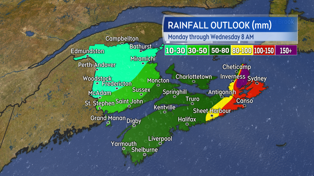
Heavier rain (dark green/yellow) develops in the southwest as early as Monday morning. After that, it is a slow shift eastward into, and through, Tuesday.
As it stands, eastern Nova Scotia is expected to see the highest overall rain totals.
A widespread 80 to over 100 mm can be expected in the eastern Halifax County and across Cape Breton. This rain falls in a span of about 36 hours.
There will also be a risk of flooding and flash flooding. Communities in Cape Breton County and Victoria County in Cape Breton should be especially cautious as a number of forecast models continue to come in with a risk of pockets of 150 mm or higher. Victoria County has an elevated risk of seeing those higher amounts due to lift provided by the higher terrain. Should you encounter washouts, be aware that flood waters on roads can be deceptively deep and fast moving.
The remainder of Nova Scotia, parts of southern New Brunswick, and P.E.I. can expect a general rainfall of 50 to 80 mm. Some localized flooding may occur. Rainfall totals taper lower moving further north into New Brunswick. Expect reduced visibility and hydroplaning conditions on roadways at times Monday and Tuesday.
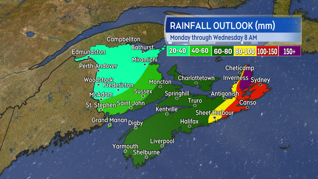
The highest rainfall totals are expected in eastern Nova Scotia. For much of Nova Scotia, southern New Brunswick and Prince Edward Island, enough rain is expected that there is a risk of poor driving conditions and localized flooding.
There is a risk of high winds for Nova Scotia and P.E.I. late Monday into Tuesday. Southerly wind gusts 70 to 90 km/h will develop near the Atlantic coastline of Nova Scotia Monday evening.
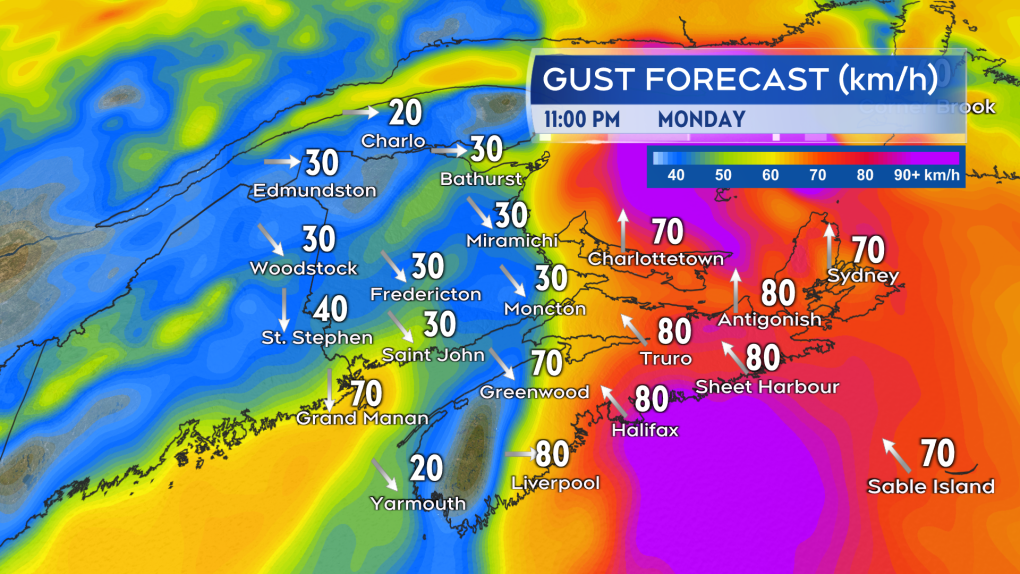
Strong southerly wind gusts will develop near the Atlantic coastline of Nova Scotia Monday evening.
Those stronger winds shift eastward Monday night into Tuesday morning, bringing a risk of gusts to 90 km/h to P.E.I. and Cape Breton. For Cape Breton, the stronger winds persist into Tuesday afternoon before diminishing Tuesday evening. Due to the topography of the Cape Breton Highlands it’s very likely that northern Inverness County experiences gusts up to, or exceeding, 110 km/h Tuesday morning and afternoon (Les Suetes Wind).
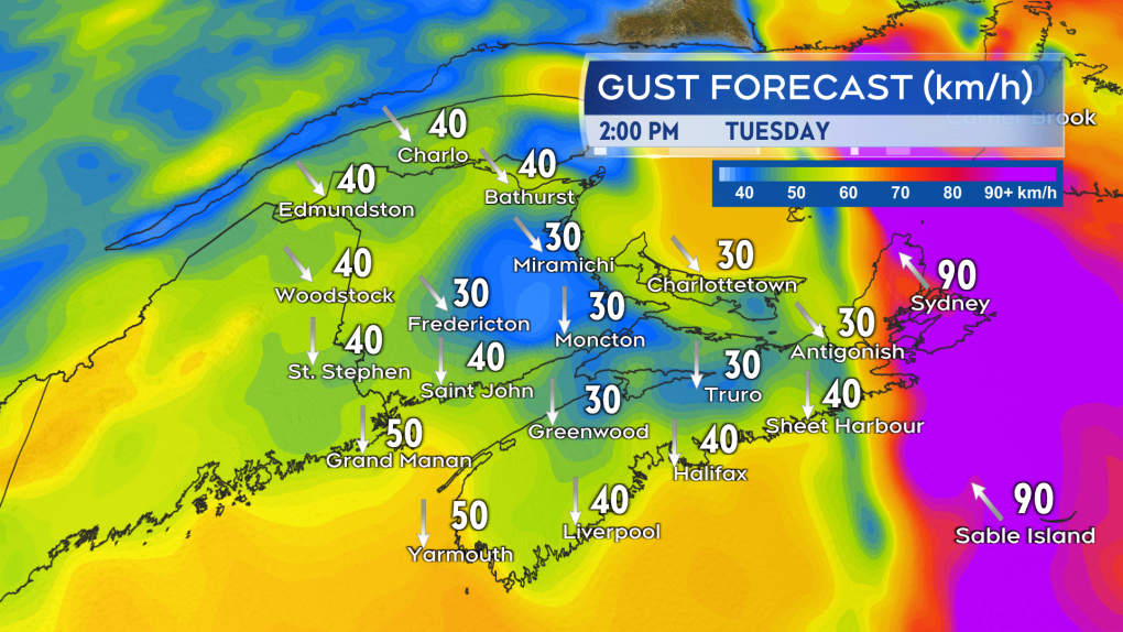
Like the rain, the strongest of the winds shift eastward into, and through, Tuesday.
Best to secure any easily windblown objects such as Christmas decorations and be aware that there could be some power outages.
Check frequently on your forecast. Special Weather Statements are still in effect by Environment Canada for much of the Maritimes. Some areas will assuredly see weather warnings issued.


CTVNews.ca Top Stories

Canada, G7 urge 'all parties' to de-escalate in growing Mideast conflict
Canada called for "all parties" to de-escalate rising tensions in the Mideast following an apparent Israeli drone attack against Iran overnight.
'It could be catastrophic': Woman says natural supplement contained hidden painkiller drug
A Manitoba woman thought she found a miracle natural supplement, but said a hidden ingredient wreaked havoc on her health.
After hearing thousands of last words, this hospital chaplain has advice for the living
Hospital chaplain J.S. Park opens up about death, grief and hearing thousands of last words, and shares his advice for the living.
'It was all my savings': Ontario woman loses $15K to fake Walmart job scam
A woman who recently moved to Canada from India was searching for a job when she got caught in an online job scam and lost $15,000.
Families to receive Canada Child Benefit payment on Friday
More money will land in the pockets of some Canadian families on Friday for the latest Canada Child Benefit installment.
After COVID, WHO defines disease spread 'through air'
The World Health Organization and around 500 experts have agreed for the first time on what it means for a disease to spread through the air, in a bid to avoid the confusion early in the COVID-19 pandemic that some scientists have said cost lives.
Taylor Swift drops 15 new songs on double album, 'The Tortured Poets Department: The Anthology'
On Friday, the pop star released her 11th album and at 2 a.m. Eastern, she released "The Tortured Poets Department: The Anthology," featuring 15 additional songs.
American millionaire Jonathan Lehrer denied bail after being charged with killing Canadian couple
American millionaire Jonathan Lehrer, one of two men charged in the killings of a Canadian couple in Dominica, has been denied bail.
DEVELOPING
DEVELOPING G7 warns of new sanctions against Iran as world reacts to apparent Israeli drone attack
Group of Seven foreign ministers warned of new sanctions against Iran on Friday for its drone and missile attack on Israel, and urged both sides to avoid an escalation of the conflict.
Shopping Trends
The Shopping Trends team is independent of the journalists at CTV News. We may earn a commission when you use our links to shop. Read about us.


Toronto
-

'It was all my savings': Ontario woman loses $15K to fake Walmart job scam
A woman who recently moved to Canada from India was searching for a job when she got caught in an online job scam and lost $15,000.
-
Families to receive Canada Child Benefit payment on Friday
More money will land in the pockets of some Canadian families on Friday for the latest Canada Child Benefit installment.
-
What the jury didn't hear at the trial of a man accused of killing a Toronto officer
Here are some other things jurors didn’t hear about the case.
Calgary
-

Calgary mayor to comment on controversial rezoning plan
Mayor Jyoti Gondek is expected to share her thoughts on Calgary's rezoning plan – one of the most contentious issues to face the city in recent years.
-
'One of the brightest little girls I know': Family of Calgary toddler killed in 2022 speaks out
Calgary police say Winston Campbell, 45, has been charged in the death of a two-year-old girl in 2022.
-
Students helping food insecure students through the U of C's Science Community Garden
Science students at the University of Calgary use their roof top greenhouse to conduct all kinds of projects and had a little extra space that wasn't being used. so some of them came up with the idea of growing food for the campus food bank.
Edmonton
-

MacKinnon has 2 assists, breaks franchise's single-season points mark as Avs beat Oilers 5-1
Valeri Nichushkin scored twice, Nathan MacKinnon added two assists to break the franchise’s single-season points mark and the Colorado Avalanche cruised into the playoffs behind a 5-1 win over the Edmonton Oilers on Thursday night.
-
WEATHER
WEATHER Josh Classen's forecast: Cool spell ends today as warmer air returns through the weekend
We'll get our fourth consecutive cooler-than-average day today and that's where the streak will end.
-
New study explores visitor experiences in Alberta dark sky preserves
The health and environmental benefits of protecting a region from light pollution are already well established, and one only has to look at the stream of visitors to the Jasper Dark Sky Festival or the Alberta's newest dark sky preserve in Lakeland Provincial Park to get a sense of how "astrotourism" can boost rural economies.
Montreal
-

American millionaire Jonathan Lehrer denied bail after being charged with killing Canadian couple
American millionaire Jonathan Lehrer, one of two men charged in the killings of a Canadian couple in Dominica, has been denied bail.
-
Here are the Montreal road closures planned for the weekend
Those driving in and around Montreal on the weekend should be aware that construction work will result in some major route closures.
-
Quebec judge suspends parts of Bill 96 that apply to English school boards
The English Montreal School Board (EMSB) is celebrating what it calls a 'significant win' in court after a judge stayed parts of Quebec's language laws that apply to English school boards across the province.
Ottawa
-

OPP reminds drone operators it's illegal to operate a drone near emergency sites following Hwy. 417 fatal crash
Ontario Provincial Police are reminding people that it is illegal to fly a drone over traffic collision sites, after drone footage captured over a fatal crash on Hwy. 417 in Ottawa appeared online.
-
5 vehicles a day reported stolen in Ottawa so far in 2024, statistics show
Statistics available on the Ottawa Police Service's crime map shows there have been 560 vehicle thefts reported across Ottawa since Jan. 1. Police reported 504 vehicles stolen in the first six months of 2023, and 387 vehicle thefts between Jan. 1 and June 30, 2022.
-
Crash causes beer kegs to spill on Hwy. 401 on-ramp in Brockville, Ont.
Ontario Provincial Police responded to the single-vehicle crash on Highway 401 at West North Augusta Road early Friday morning.
London
-

Human trafficking-related charges laid by London police
London police have charged a man from Manitoba with human trafficking-related charges. Police in the 600 block of Wellington Rd. near Wilkins Street when they saw a vehicle with stolen plates in a parking lot.
-
Crash causes power outage in St. Thomas
According to police, there was “significant damage” to the hydro pole, causing a power outage to the surrounding areas.
-
Man arrested after police locate stolen vehicle
A Lucan man is facing a number of charges after police said they recovered a stolen truck.
Barrie
-

Serious rollover on Highway 400 sends mother to hospital
Person airlifted to Toronto after a rollover on Highway 400 Friday morning.
-
Clock ticking on CAA's Worst Roads campaign
CAA's Worst Roads campaign ensures municipalities know which roads its residents feel need rapid improvement.
-
Driver suffers life-threatening injuries in Hwy 12 collision
One person suffered life-threatening injuries after a collision with a commercial vehicle on Highway 12 at Forest Avenue in Orillia early Thursday afternoon.
Northern Ontario
-
 BREAKING
BREAKING Sudbury police investigating threat found in high school bathroom stall
Sudbury police will have an increased presence at a local high school after two threatening messages were found in a bathroom stall.
-
Fatal crash at northern Ont. business on Highway 17
One person has died as the result of a single-vehicle crash at a northern Ontario business on Highway 17 on Thursday afternoon, police say.
-
Families to receive Canada Child Benefit payment on Friday
More money will land in the pockets of some Canadian families on Friday for the latest Canada Child Benefit installment.
Kitchener
-

Landlords reporting increase in tenants refusing to pay rent or leave
A property management company in Fergus is still cleaning up after they say a tenant trashed one of their units and refused to pay rent -- and they say it's not the only similar case they've dealt with recently.
-
Strange beasts stalking Silver Lake in Waterloo
Don’t be alarmed if you see some strange new creatures in Waterloo Park.
-
Ontario Review Board hearing considers Udo Haan’s future
An Ontario Review Board hearing was held at the Southwest Centre for Forensic Mental Health Care in St. Thomas on Thursday to consider the future of Udo Haan.
Windsor
-

Police in Windsor looking for Ramtin Bayat
Windsor police are asking the public to keep an eye out for a man last seen in the downtown area.
-
Store employee threatened with knife during robbery
Police said a person went to a market in the 2100 block of Huron Church Road near McKay Avenue and left the store without paying for about $200 worth of items.
-
Missing 82-year-old man has been found
Windsor police have located an 82-year-old man.
Winnipeg
-

WINSAR members ready to answer the call for missing persons
In southern Manitoba, members of Winnipeg Search and Rescue (WINSAR) remain vigilant as they assist in finding a missing Manitoban.
-
'It could be catastrophic': Woman says natural supplement contained hidden painkiller drug
A Manitoba woman thought she found a miracle natural supplement, but said a hidden ingredient wreaked havoc on her health.
-
Winnipeg Jets release Round 1 playoff schedule
The Winnipeg Jets have released its first round playoff schedule.
Regina
-

'Poor choice of words': Education Minister apologizes for remarks made to Sask. mother
On Thursday, Education Minister Jeremy Cockrill apologized for remarks he made to a mother who had advocated for better classroom supports earlier this week.
-
Sask. dental providers and seniors raise concerns over federal dental care plan
With the Canadian Dental Care Plan (CDCP) set to roll out on May 1, many dental care providers have concerns and unanswered questions about the plan.
-
'Bad taste in your mouth': Regina man mistakenly told he won $50K boat through Roll up the Rim
Chris Ross was pleasantly surprised when Tim Hortons sent him an email summarizing his "Roll up the Rim" winnings for the season. The email claimed Ross had won a boat valued at over $50,000 – but it was a mistake.
Saskatoon
-
'Poor choice of words': Education Minister apologizes for remarks made to Sask. mother
On Thursday, Education Minister Jeremy Cockrill apologized for remarks he made to a mother who had advocated for better classroom supports earlier this week.
-
Saskatoon police committing three officers to curb crime in Pleasant Hill
The Saskatoon Police Service (SPS) is dedicating three officers to a specialized unit to help curb crime in the Pleasant Hill neighbourhood.
-
New Sask. dental hygienist degree program to offer strictly evening classes
A new dental hygienist degree program is launching at the University of Saskatchewan (U of S) in September to help meet a growing demand for oral health specialists.
Vancouver
-

Teen charged with 4 counts of robbery after allegedly snatching iPhones at SkyTrain station
Metro Vancouver Transit Police say a young offender has been charged with four counts of robbery in relation to incidents that occurred at a Burnaby transit hub over the course of a year.
-
Facebook Marketplace seller must refund buyer over false advertising, B.C. tribunal decides
A Facebook Marketplace seller is being ordered by B.C.'s small claims tribunal to repay hundreds of dollars after selling a product under false advertising.
-
Bigger boats, more nets, people arrive in Zeballos, B.C., for new orca rescue attempt
A large seine fishing vessel capable of casting a net strong enough to hold a nearly 700-kilogram killer whale calf has arrived in Zeballos, B.C., to participate in the latest attempt to rescue the young orca stranded in a remote tidal lagoon.
Vancouver Island
-

Bigger boats, more nets, people arrive in Zeballos, B.C., for new orca rescue attempt
A large seine fishing vessel capable of casting a net strong enough to hold a nearly 700-kilogram killer whale calf has arrived in Zeballos, B.C., to participate in the latest attempt to rescue the young orca stranded in a remote tidal lagoon.
-
Facebook Marketplace seller must refund buyer over false advertising, B.C. tribunal decides
A Facebook Marketplace seller is being ordered by B.C.'s small claims tribunal to repay hundreds of dollars after selling a product under false advertising.
-
Jets take down Canucks 4-2 as both teams wrap up regular season
Nikita Chibrikov scored the game-winner in his NHL debut and Cole Perfetti tallied a pair of goals as the Winnipeg Jets defeated the Vancouver Canucks 4-2 to close out their regular seasons on Thursday.
Kelowna
-

Stolen snake named Milkshake returned to Kelowna pet store
A banana ball python that was stolen from a Kelowna pet store on Saturday has been returned unharmed, Mounties said.
-
Nurses rally at B.C. Interior hospital over security, staffing concerns
Nurses held a rally Wednesday at a hospital in the B.C. Interior that closed its emergency department more than a dozen times last year due to insufficient staff.
-
B.C. to add 240 complex-care housing units throughout province
British Columbia is planning to add 240 new units to its complex-care housing program, providing homes for people with mental-health and addictions challenges that overlap with other serious conditions.


