Kalin's call: Heavy rain to fall in Maritimes as Hurricane Larry passes to the East

HALIFAX -
It’s a crowded weather picture in Atlantic Canada these days. A slow moving front from the west will continue to bring rain, showers, and gusty southerly winds to the Maritimes Thursday and Friday. In the meantime, Hurricane Larry now looks more likely make landfall in eastern Newfoundland late Friday night.
Starting with the rain for the Maritimes, the heaviest rain is expected in western and northern areas of New Brunswick. It is that area in the Maritimes that the front looks to stall Thursday night into Friday morning, before clearing to the east in the afternoon taking the rain with it.
A widespread 30 to 60 mm is expected across much of the west and north of New Brunswick. An area near and along a line stretching from Carleton County to Bathurst and the Chaleur Area is likely to finish with some totals between 60 and 100 mm. The risk of localized flooding and flash flooding will be highest through that part of the region. Rainfall warnings are in effect by Environment Canada.
Southern New Brunswick, Prince Edward Island and Nova Scotia will see some widespread rain amounts of 10 to 30 mm. Local rain amounts approaching 40 mm are possible on, and near, the Atlantic coastline of Nova Scotia.
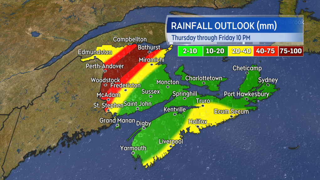
Soggy through Friday with rain and showers for the region. The heaviest rain, and highest risk of localized flooding, in western and northern areas of New Brunswick.
Gusty southerly winds will accompany the wet weather. Peak gusts of 30 to 60 km/h are expected Thursday night and Friday morning. The wind will turn west Friday afternoon and evening. West winds will continue on the gusty side for Saturday.
Hurricane Larry is now a Category 1 hurricane with maximum sustained winds near the eye of 150 km/h as it moves east of Bermuda.
The storm is still expected to pass through the marine areas, east of Sable Island, of the Maritimes on Friday as a category 1 hurricane. A landfall late Friday night looks likely on the Avalon Peninsula in Newfoundland as either a Category 1 hurricane or a strong post-tropical storm. A combination of Tropical Storm and Hurricane Watches have been issued for eastern Newfoundland.
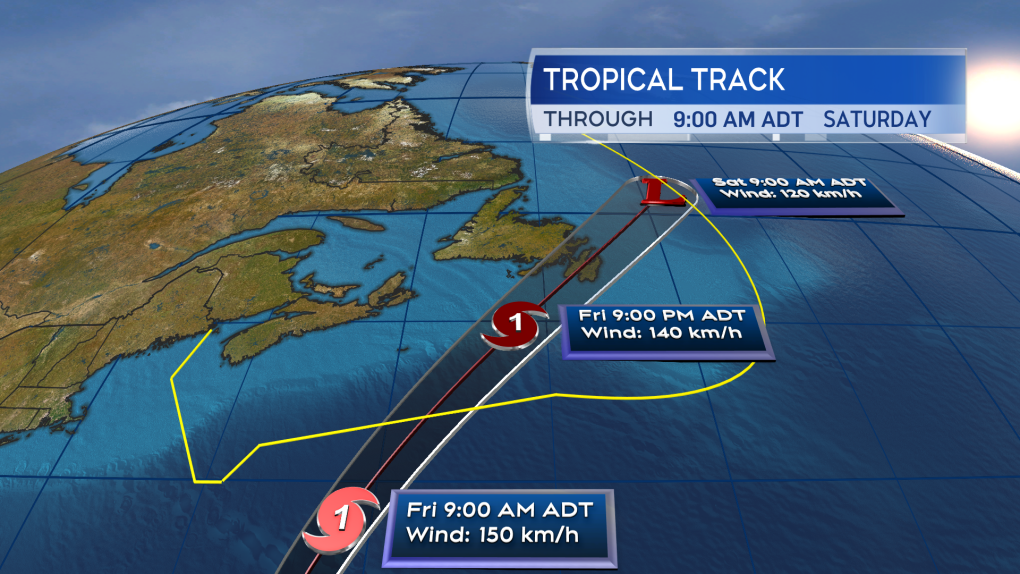
Hurricane Larry is forecast to pass east of Sable Island and then most likely landfall in eastern Newfoundland as a category 1 hurricane or strong post-tropical storm late Friday night.
High winds increasingly look like the biggest on-land impact for eastern Newfoundland. A large area spanning the Burin Peninsula north to the Bonavista area and then across the Avalon may experience tropical storm force winds (1 minute sustained 63+ km/h). Gusts for parts of the Avalon are almost assuredly going to reach over 100 km/h for a period between 10 p.m. on Friday and 5 a.m. on Saturday. That type of wind can cause more damage this time of the year as compared to the winter as trees are holding foliage.
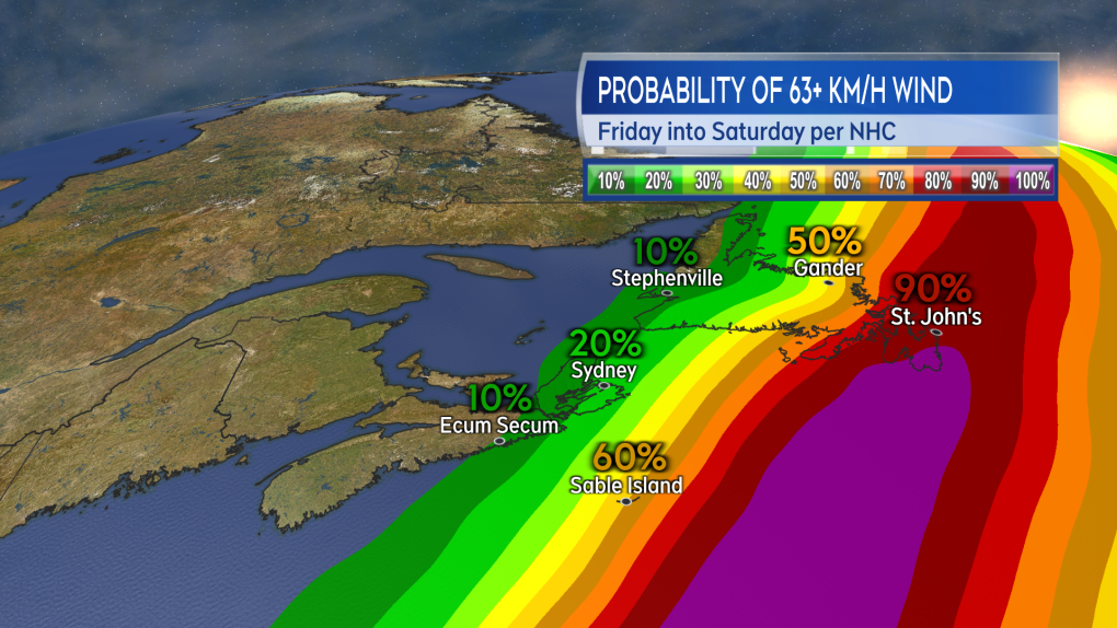
A large part of eastern Newfoundland is likely to experience tropical storm force winds. A period of gusts in excess of 100 km/h look almost assured for parts of the Avalon Friday night into early Saturday morning.
Surf and waves for marine areas and the Atlantic coastline of Nova Scotia are still forecast to increase Thursday into Friday. The peak of the increase in wave heights looks likely Friday evening and night. Some near coastal waves may reach 2.5 to near 5 metres or about 8 to 16 feet. Caution should be taken if on the coast. The waves and surf will subside on the weekend.
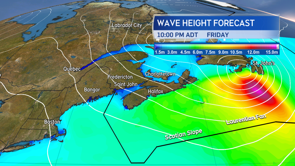
Waves and surf will increase on the Atlantic coastline of Nova Scotia into Friday. A peak is likely Friday evening and night before surf subsides through the weekend.
Updates on the rain and the hurricane tonight on CTV Atlantic News 5, 6, and 11:30 PM.


CTVNews.ca Top Stories

Quebec nurse had to clean up after husband's death in Montreal hospital
On a night she should have been mourning, a nurse from Quebec's Laurentians region says she was forced to clean up her husband after he died at a hospital in Montreal.
'Anything to win': Trudeau says as Poilievre defends meeting protesters
Prime Minister Justin Trudeau is accusing Conservative Leader Pierre Poilievre of welcoming 'the support of conspiracy theorists and extremists,' after the Conservative leader was photographed meeting with protesters, which his office has defended.
'My stomach dropped': Winnipeg man speaks out after being criminally harassed following single online date
A Winnipeg man said a single date gone wrong led to years of criminal harassment, false arrests, stress and depression.
What is changing about Canada's capital gains tax and how does it impact me?
The federal government's proposed change to capital gains taxation is expected to increase taxes on investments and mainly affect wealthy Canadians and businesses. Here's what you need to know about the move.
Bank of Canada officials split on when to start cutting interest rates
Members of the Bank of Canada's governing council were split on how long the central bank should wait before it starts cutting interest rates when they met earlier this month.
Pilot reported fire onboard plane carrying fuel, attempted to return to Fairbanks just before crash
One of the two pilots aboard an airplane carrying fuel reported there was a fire on the airplane shortly before it crashed and burned outside Fairbanks, killing both people on board, a federal aviation official said Wednesday.
'One of the single most terrifying things ever': Ontario couple among passengers on sinking tour boat in Dominican Republic
A Toronto couple are speaking out about their 'extremely dangerous' experience on board a sinking tour boat in the Dominican Republic last week.
7 surveillance videos linked to extortions of South Asian home builders in Edmonton released
The Edmonton Police Service has released a number of surveillance videos related to a series of extortion cases in the city now dubbed 'Project Gaslight.'
Ukraine uses long-range missiles secretly provided by U.S. to hit Russian-held areas, officials say
Ukraine for the first time has begun using long-range ballistic missiles provided secretly by the United States, bombing a Russian military airfield in Crimea last week and Russian forces in another occupied area overnight, American officials said Wednesday.
Shopping Trends
The Shopping Trends team is independent of the journalists at CTV News. We may earn a commission when you use our links to shop. Read about us.


Toronto
-

Speed limits to increase on some sections of Ontario highways, province says
The Ontario government says it will be raising the speed limit along certain stretches of provincial highways soon, including Highway 401 and Highway 403.
-
New condo sales in the Toronto area hit low not seen since financial crisis
New condo sales in the Toronto region dropped to the lowest quarterly total since the financial crisis in 2009 amid high interest rates and affordability issues, a new report has found.
-
'One of the single most terrifying things ever': Ontario couple among passengers on sinking tour boat in Dominican Republic
A Toronto couple are speaking out about their 'extremely dangerous' experience on board a sinking tour boat in the Dominican Republic last week.
Calgary
-

'Disingenuous and misleading': Calgary mayor, province at odds over plan to lower utility bills
Calgary's mayor is sparring with the Government of Alberta over the rollout of new legislation meant to lower utility bills in Calgary.
-
Quest School's new Sunalta campus focuses on high school student learning and an adult transition program
Quest School has expanded to a second campus in Calgary that is an innovative learning hub for high school students and young adults with moderate to severe developmental disabilities.
-
Bell no longer a Calgary Stampede sponsor after nearly 20 years
Bell Canada, the parent company of CTV News, is no longer a sponsor of the Calgary Stampede.
Edmonton
-

Measles case in Edmonton prompts exposure warning
Alberta Health Services issued a measles alert in Edmonton Wednesday after confirming a case.
-
7 surveillance videos linked to extortions of South Asian home builders in Edmonton released
The Edmonton Police Service has released a number of surveillance videos related to a series of extortion cases in the city now dubbed 'Project Gaslight.'
-
8.9% property tax approved by Edmonton council
Edmonton city council unanimously agreed on an 8.9-per cent property tax increase Tuesday evening.
Montreal
-
Quebec nurse had to clean up after husband's death in Montreal hospital
On a night she should have been mourning, a nurse from Quebec's Laurentians region says she was forced to clean up her husband after he died at a hospital in Montreal.
-
REM delayed: Stations in West Island, North Shore now opening in 2025
Officials for Montreal's REM line confirmed that the lines to the West Island and the North Shore are being delayed and won't open until 2025.
-
Quebec grants $40 million for cleanup of Montreal Olympic Stadium after fire
The Quebec government has awarded the organization that manages Montreal's Olympic Stadium up to $40 million to pay for repairs and decontamination after a March 21 fire.
Ottawa
-

NCC buys golf course near Gatineau Park for $3.9 million
The National Capital Commission has purchased the old Dunnderosa Golf Course in Chelsea, Que., as part of its plan to acquire private properties in Gatineau Park.
-
Residents raise concerns about plan for Inuit women's shelter in Ottawa's south end
Residents in Ottawa's Hunt Club neighbourhood are raising concerns about plans to build an Inuit women's shelter in the south end neighbourhood.
-
Eastern Ont. knitters make 80 peacekeeper 'Izzy Dolls' for D-Day anniversary
Volunteers in Perth, Ont. have knit small peacekeeper "Izzy Dolls" that will be sent to France in commemoration of the 80th anniversary of D-Day and the Battle of Normandy.
London
-

Nuclear waste referendum date set for October
Residents in the Municipality of South Bruce will decide whether they want to host Canada’s first permanent nuclear waste storage facility this October.
-
How do U.S. decisions about TikTok impact Canada?
U.S. President Joe Biden has signed a bill that will force TikTok to be sold or be banned in his country, but what does it mean for Canada?
-
'I think 110 is fast enough': Speed limit to increase on some sections of 400 series highways
The speed you travel on sections of 400 series highways in our region is increasing. The province says it will raise the speed limit to 110 km/h on multiple sections, including some in the London region.
Barrie
-

Suspected remains of missing Thornbury man found six years after disappearance
It was mid-October 2018 when Eric Spencer was last seen in Honey Harbour, a full-scale search by the OPP for the then 60-year-old from Thornbury scaled back when the search came up empty.
-
U.S. Marshals join search for Wasaga Beach kidnapping suspect
U.S. Marshals joins search for Deshawn Davis, one of Canada’s most wanted, accused of the kidnapping of Elnaz Hajtamiri in Wasaga Beach January 2022 and the suspect in a nightclub shooting that took place in May of last year.
-
Video surveillance footage reveals bizarre break-in at local vet hospital
Barrie Police laid charges on a man after video surveillance captured him breaking into a store and smashing the front glass door.
Northern Ontario
-

Northern Ont. lawyer who abandoned clients in child protection cases disbarred
A North Bay, Ont., lawyer who abandoned 15 clients – many of them child protection cases – has lost his licence to practise law.
-
'My stomach dropped': Winnipeg man speaks out after being criminally harassed following single online date
A Winnipeg man said a single date gone wrong led to years of criminal harassment, false arrests, stress and depression.
-
OPP and Treaty Three police lay murder charge in northwestern Ont.
The Ontario Provincial Police, in partnership with the Treaty Three Police Service, have charged a suspect with murder following a homicide in a remote northwestern Ontario community.
Kitchener
-

Undisclosed project filming in Cambridge today
Expect delays on Queen Street in Cambridge today as film crew shoots in the area.
-
Pedestrian seriously hurt after crash in Kitchener
A pedestrian had to be taken to an out-of-region hospital following a crash in Kitchener.
-
Grand River and St. Mary's hospitals could merge in 2025
Grand River Hospital and St. Mary’s General Hospital are looking to merge into a single new hospital organization by the spring of 2025.
Windsor
-
 BREAKING
BREAKING Convicted killer can ask for parole now: Windsor, Ont. jury accepts 'faint hope' application
A Windsor man convicted in a violent murder 20 years ago was successful in his ‘faint hope’ bid for an early chance at freedom after a jury agreed he should be given the chance to apply for early parole eligibility.
-
Essex concert series needs to pay its performers, say local musicians
If musicians are the sole focus of a commercial event, those performers should be paid for their efforts. That's according to a local musician who set up an online petition after the Town of Essex issued a call for artists to perform at their annual summer concert series for free.
-
Witnesses sought after Porsche and motorcycle collide
The Windsor Police Collision Reconstruction Unit is looking for witnesses after a collision involving a motorcycle and a Porsche.
Winnipeg
-

Manitoba government tables bill to end ban on homegrown recreational cannabis
Manitoba is planning to lift its ban on the home growing of recreational cannabis.
-
'I just wanted to stand out': Winnipeg Jets fan goes viral for wearing salmon shirt at Whiteout
A Winnipeg Jets fan found a unique way to stand out amid the Winnipeg Whiteout; he wore a salmon-coloured shirt.
-
Child dies following collision with trailer: Brandon police
A four-year-old child has died following a collision with a trailer in Brandon, Man.
Regina
-

'Learn to walk again': Sask. doctor tells story of miracle recovery from deadly heart condition
It was a powerful morning at Regina's Conexus Arts Centre Wednesday, where the Lieutenant Governor hosted the annual Saskatchewan Prayer Breakfast and a provincial doctor told his story of survival from a deadly heart condition.
-
Throwing star, crossbow found during Sask. RCMP searches at George Gordon FN, Punnichy
A throwing star and crossbow were among the seizures by police as part of a drug trafficking investigation on George Gordon First Nation and in Punnichy, Sask. last week.
-
Sask. police caught 454 impaired drivers in March: SGI
Saskatchewan police caught 454 impaired drivers around the province in March. Of those, 142 are facing Criminal Code charges and the other 312 faced licence suspensions, according to a news release from Saskatchewan Government Insurance (SGI).
Saskatoon
-
Sask. woman fights to find out who had her apprehended for a psych. assessment
A Saskatchewan woman who was taken for an involuntary mental health assessment is entitled to find out who had her committed, a provincial court judge has ruled.
-
Sask. judge sets date to decide if evidence in fatal THC-impaired driving case is admissible
A date has been set for a Saskatoon judge to decide whether a woman’s admission to consuming drugs can be used in her trial.
-
Punched, kicked, spat on: Saskatoon Transit workers call for help after violent assaults
The union representing the city’s bus drivers says violence against transit workers is out of control.
Vancouver
-

'It was instant karma': Viral video captures failed theft attempt in Nanaimo, B.C.
Mounties in Nanaimo, B.C., say two late-night revellers are lucky their allegedly drunken escapades weren't reported to police after security cameras captured the men trying to steal a heavy steel sign from a downtown business.
-
RCMP officers 'refused' to provide evidence to Crown to assist drug, firearms prosecution: report
Crown counsel was unable to approve "significant" drug and weapons charges stemming from an arrest in Quesnel, B.C., last year because the officers involved "refused to provide any evidence," according to a report from the province’s police watchdog.
-
B.C. man rescues starving dachshund trapped in carrier: BC SPCA
An emaciated dachshund is now recovering thanks to a Good Samaritan who found the pup near a biking trail in Kelowna, according to the BC SPCA.
Vancouver Island
-
'It was instant karma': Viral video captures failed theft attempt in Nanaimo, B.C.
Mounties in Nanaimo, B.C., say two late-night revellers are lucky their allegedly drunken escapades weren't reported to police after security cameras captured the men trying to steal a heavy steel sign from a downtown business.
-
RCMP officers 'refused' to provide evidence to Crown to assist drug, firearms prosecution: report
Crown counsel was unable to approve "significant" drug and weapons charges stemming from an arrest in Quesnel, B.C., last year because the officers involved "refused to provide any evidence," according to a report from the province’s police watchdog.
-
B.C. man rescues starving dachshund trapped in carrier: BC SPCA
An emaciated dachshund is now recovering thanks to a Good Samaritan who found the pup near a biking trail in Kelowna, according to the BC SPCA.
Kelowna
-

B.C. man rescues starving dachshund trapped in carrier: BC SPCA
An emaciated dachshund is now recovering thanks to a Good Samaritan who found the pup near a biking trail in Kelowna, according to the BC SPCA.
-
Search crews called in after missing Kelowna senior's truck found
Search and rescue crews have been called in after a vehicle belonging to a missing senior was located near a rural intersection outside of Kelowna Tuesday.
-
Homicide investigation underway after body found near Kelowna, B.C.
Major crime detectives in British Columbia are investigating a suspected homicide after a body was found in a remote area southeast Kelowna over the weekend.


