Kalin's Call: Hurricane Larry forecast east of Maritimes, possible landfall in Newfoundland
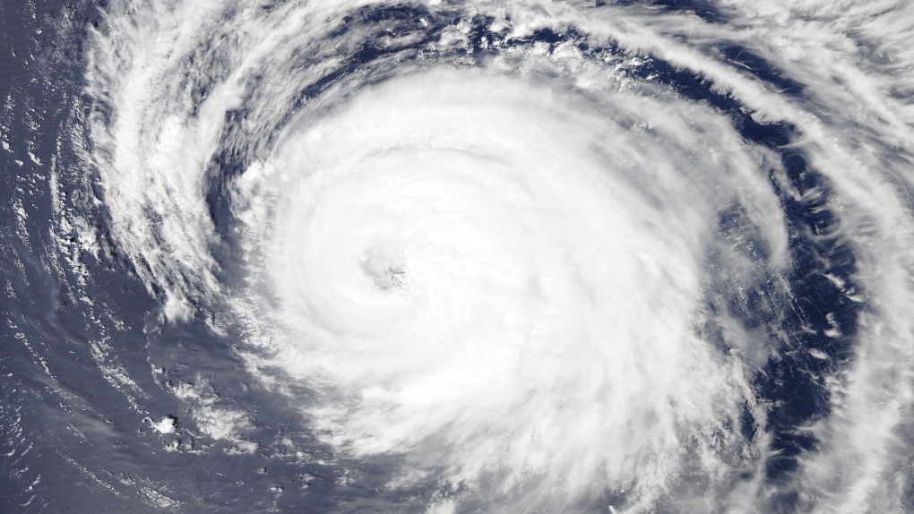 Category 3 Hurricane Larry on high resolution satellite imagery courtesy of NASA. The storm is spinning about 1,210 km southeast of Bermuda.
Parts of Newfoundland could see landfall from hurricane Larry later this week, but most of the Maritime region is expected to avoid a direct impact from the large storm currently swirling in the Atlantic.
As of Tuesday afternoon, Larry has maintained itself as a powerful category 3 hurricane with maximum sustained winds around the eye of 185 km/h.
The storm is currently 1,210 km southeast of Bermuda and moving northwest at about 15 km/h.
 Category 3 Hurricane Larry on high resolution satellite imagery courtesy of NASA. The storm is spinning about 1,210 km southeast of Bermuda.
Category 3 Hurricane Larry on high resolution satellite imagery courtesy of NASA. The storm is spinning about 1210 km southeast of Bermuda.
The latest forecast track for the hurricane takes it just east of Bermuda as a category 2 hurricane Thursday morning. From there it is forecast to enter our marine districts of either the East Scotian Slope or Laurentian Fan by Friday afternoon.
The forecast track then has a possible landfall as a category 1 hurricane or strong post-tropical storm on the Avalon Peninsula of Newfoundland late Friday night or very early Saturday morning. The width of the forecast cone, or area the storm may take a path through, is about 400 km at that forecast time though which means a pass east of the Avalon is still a very real possibility. There is also a chance it could track slightly further west into Newfoundland as well.
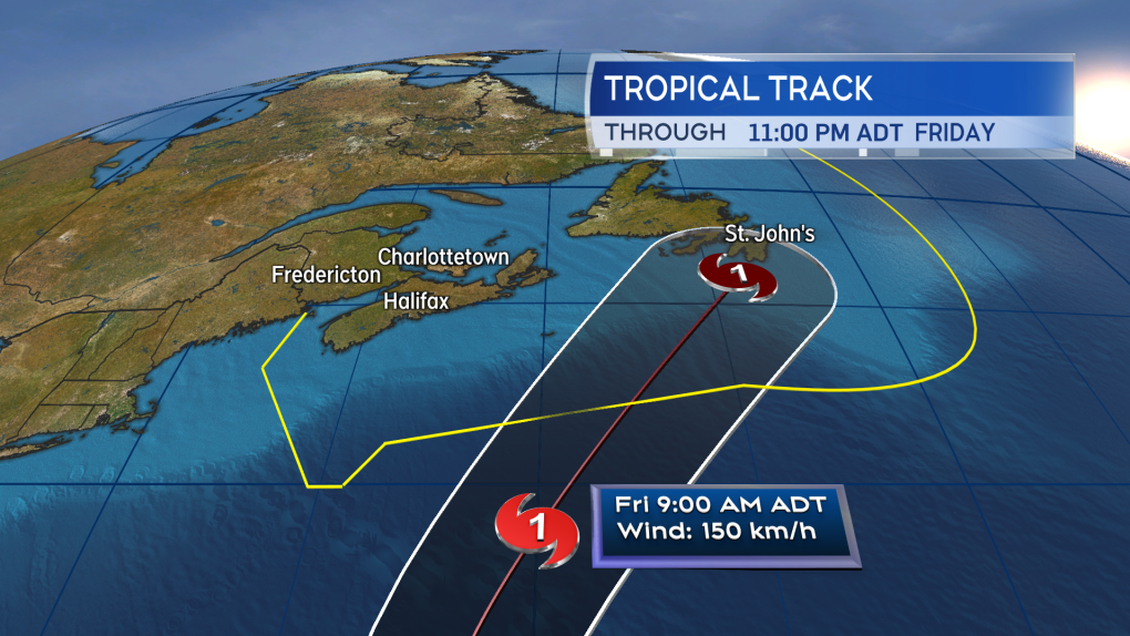 The Avalon Peninsula of Newfoundland is currently within the forecast cone for Hurricane Larry. A landfall as a category 1 hurricane or strong post-tropical storm is possible, as is a pass east of the area.
The Avalon Peninsula of Newfoundland is currently within the forecast cone for Hurricane Larry. A landfall as a category 1 hurricane or strong post-tropical storm is possible, as is a pass east of the area.
A weather statement has been issued by the Canadian Hurricane Centre for the Avalon Peninsula of Newfoundland cautioning that there is a need to check frequently in on the forecast this week as there may be impacts from heavy rain and high wind brought on by the storm.
There is only a low chance that parts of eastern Nova Scotia could experience tropical storm force winds (one minute wind of 63+ km/h).
According to the the latest forecast from the National Hurricane Center, there is about a 20% chance that Sydney could see tropical storm force winds, lowering to a 10% chance for the Eastern Shore of mainland Nova Scotia. Comparatively, St. John’s, N.L. currently has a 70% chance of tropical storm force winds in the same forecast.
 There is only a low chance that eastern areas of Nova Scotia could experience tropical storm force winds on Friday in the current forecast for Hurricane Larry.
There is only a low chance that eastern areas of Nova Scotia could experience tropical storm force winds on Friday in the current forecast for Hurricane Larry.
An increase in ocean waves is expected Thursday into Friday particularly for the Atlantic marine districts and Atlantic coastal areas. There are some ocean wave models that increase the significant wave heights to 2.5 to four metres (eight to 13 feet) in the vicinity of the Atlantic coast of Nova Scotia on Friday.
Caution should be exercised if working or participating in recreation on the coast on that day due to the increased surf. The waves should slowly subside on the weekend.
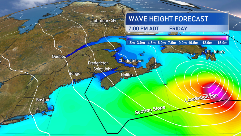 An increase in wave height and action on the Atlantic coastline of Nova Scotia is expected Thursday through Friday. Caution should be taken on the coast as the surf may become rough.
An increase in wave height and action on the Atlantic coastline of Nova Scotia is expected Thursday through Friday. Caution should be taken on the coast as the surf may become rough.
Rain is forecast for the region on Friday as a separate weather front moves in from the west. There is a chance that some tropical moisture could be drawn off Hurricane Larry and into that weather front increasing the potential for some heavy rain. We should get a better read on the chances of that happening and where that heavier rain may be more likely over the next 24 to 48 hours.
CTVNews.ca Top Stories

DEVELOPING Man sets self on fire outside New York court where Trump trial underway
A man set himself on fire on Friday outside the New York courthouse where Donald Trump's historic hush-money trial was taking place as jury selection wrapped up, but officials said he did not appear to have been targeting Trump.
BREAKING Sask. father found guilty of withholding daughter to prevent her from getting COVID-19 vaccine
Michael Gordon Jackson, a Saskatchewan man accused of abducting his daughter to prevent her from getting a COVID-19 vaccine, has been found guilty for contravention of a custody order.
She set out to find a husband in a year. Then she matched with a guy on a dating app on the other side of the world
Scottish comedian Samantha Hannah was working on a comedy show about finding a husband when Toby Hunter came into her life. What happened next surprised them both.
Mandisa, Grammy award-winning 'American Idol' alum, dead at 47
Soulful gospel artist Mandisa, a Grammy-winning singer who got her start as a contestant on 'American Idol' in 2006, has died, according to a statement on her verified social media. She was 47.
'It could be catastrophic': Woman says natural supplement contained hidden painkiller drug
A Manitoba woman thought she found a miracle natural supplement, but said a hidden ingredient wreaked havoc on her health.
Young people 'tortured' if stolen vehicle operations fail, Montreal police tell MPs
One day after a Montreal police officer fired gunshots at a suspect in a stolen vehicle, senior officers were telling parliamentarians that organized crime groups are recruiting people as young as 15 in the city to steal cars so that they can be shipped overseas.
The Body Shop Canada explores sale as demand outpaces inventory: court filing
The Body Shop Canada is exploring a sale as it struggles to get its hands on enough inventory to keep up with "robust" sales after announcing it would file for creditor protection and close 33 stores.
Vicious attack on a dog ends with charges for northern Ont. suspect
Police in Sault Ste. Marie charged a 22-year-old man with animal cruelty following an attack on a dog Thursday morning.
On federal budget, Macklem says 'fiscal track has not changed significantly'
Bank of Canada governor Tiff Macklem says Canada's fiscal position has 'not changed significantly' following the release of the federal government's budget.


