
HALIFAX -- A cold front moving in from the west will bring scattered showers and a risk of thunderstorms to the Maritimes on Tuesday.
The front is expected to arrive in New Brunswick by Tuesday afternoon, with the highest shower chances for that province from noon until 8 p.m.
Shower chances are highest for P.E.I. from 3 p.m. to 10 p.m., and from 4 p.m. to midnight for Nova Scotia. Any occurring thunderstorms are expected to be small with the greatest hazard being lightning.
Remember, ‘when thunder roars, head indoors,’ and wait 30 minutes until after the last rumble before moving back outside. Based on data from 2002 to 2017, Canada sees a yearly average of two to three people killed, and 100 to 150 people injured by lightning.
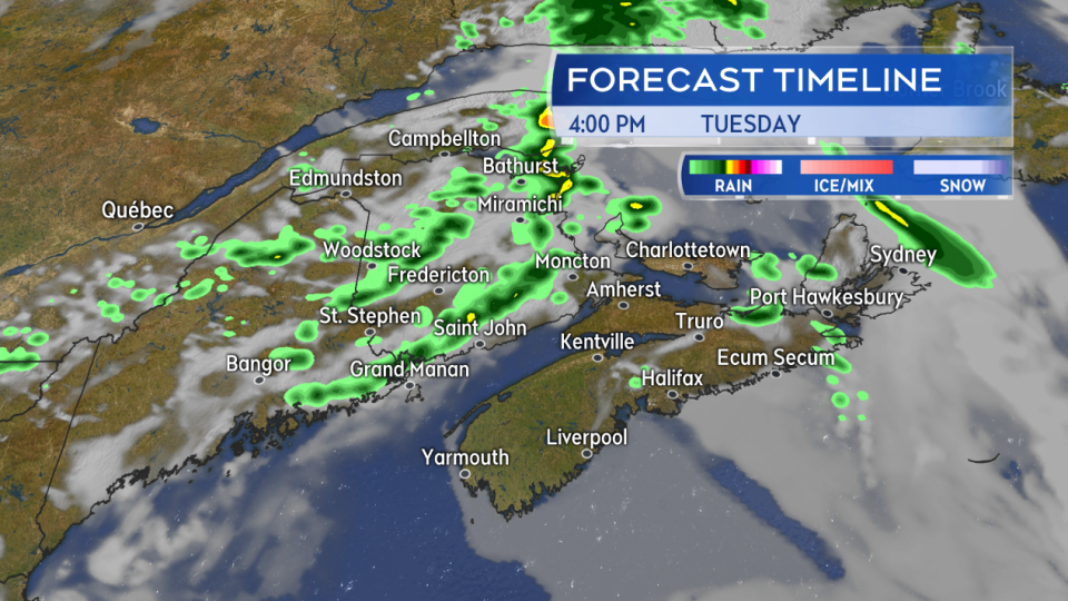
Broken lines of showers are expected along the cold front Tuesday, with a risk of thunderstorms. The shower chances highest in New Brunswick for the afternoon, and late afternoon and evening for P.E.I. and Nova Scotia.
The front is clear of the Maritimes by early Wednesday morning with much of the remainder of the week forecast expected to be fair.
Temperatures will be cooler for P.E.I. and eastern areas of Nova Scotia on Wednesday, with highs held between eight and 12 degrees in a north wind, along with a low chance of showers. The remainder of the Maritimes will climb into the mid-to-high teens with temperatures in the low twenties possible for southwestern New Brunswick.
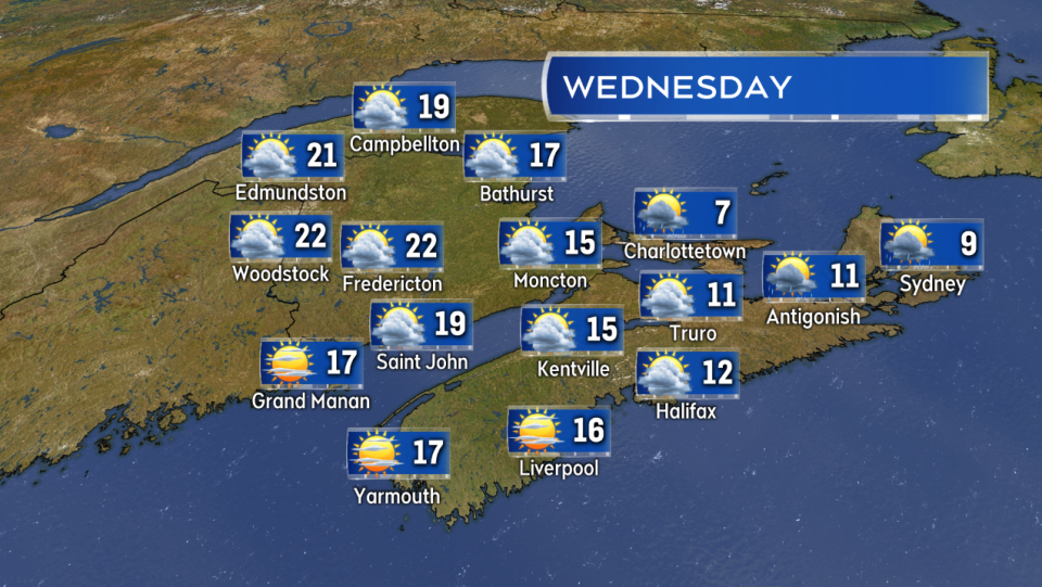
A mix of sun and cloud with breezy to blustery winds on Wednesday. P.E.I. and eastern areas of Nova Scotia will see cooler temperatures with a low chance of showers.
Above seasonable high temperatures are expected for most of the region into the upcoming weekend. Friday, Saturday, and Sunday could all see high temperatures fairly widespread into the high teens and even some low-to-mid twenties temperatures. Cooler exceptions present on parts of the coast where a sea breeze sets up to come in off ocean waters.
A warm air mass is expected to be present through the end of the week and into at least the start of the upcoming May long weekend.
Looking for a more widespread, soaking rain? Not much chance over the next several days. After the scattered showers on Tuesday we may be waiting until Sunday for the possibility of another front to come through. Even then that type of weather front would most likely only bring another round scattered showers. No washout for the May long weekend this year, barring a large change in the long range forecast.


