Kalin's Call: Mix of heavy snow, ice pellets, freezing rain, and rain is headed for the Maritimes

A low-pressure system from the Great Lakes will merge with a second low moving up the eastern seaboard of the United States to form a coastal storm in the vicinity of the Maritimes Wednesday. The storm will then cross eastern Nova Scotia and move into the Gulf of St. Lawrence by Thursday morning.
A mix of heavy snow, ice pellets, freezing rain, and rain is expected for the region. High and gusty winds are also predicted for some areas.
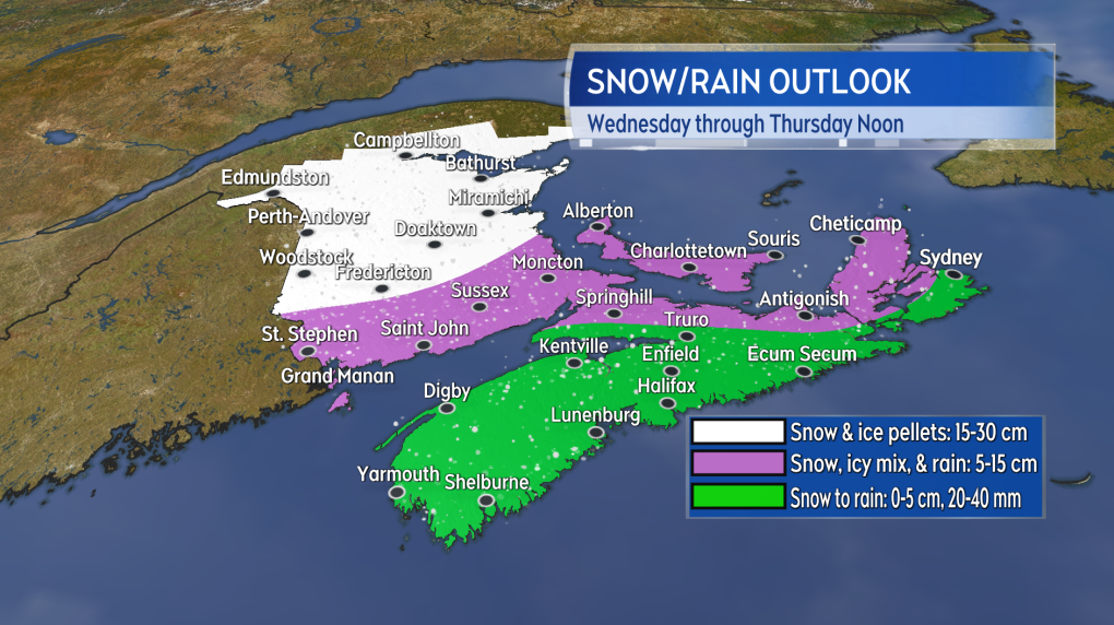
The most snow looks like it will fall across northern and central New Brunswick. A range of 15 to 30 cm can generally be expected north of Fredericton. Areas south of Fredericton can expect 5 to 15 cm in a mix of snow, ice pellets, freezing rain, and rain. Prince Edward Island can expect a similar mix with a range of 5 to 15 cm, with the best chance of seeing the higher amounts in Prince County. Some northern and eastern areas of Nova Scotia would also have a chance of some initial accumulation in excess of 5 cm before a turn to rain. Most of that province though is likely to see 5 cm or less before a 20 to 40 mm rainfall.

A heavy snowfall is likely for northern and central New Brunswick. Accumulations lower as more ice and rain mix in for southern New Brunswick, Prince Edward Island, and Nova Scotia.
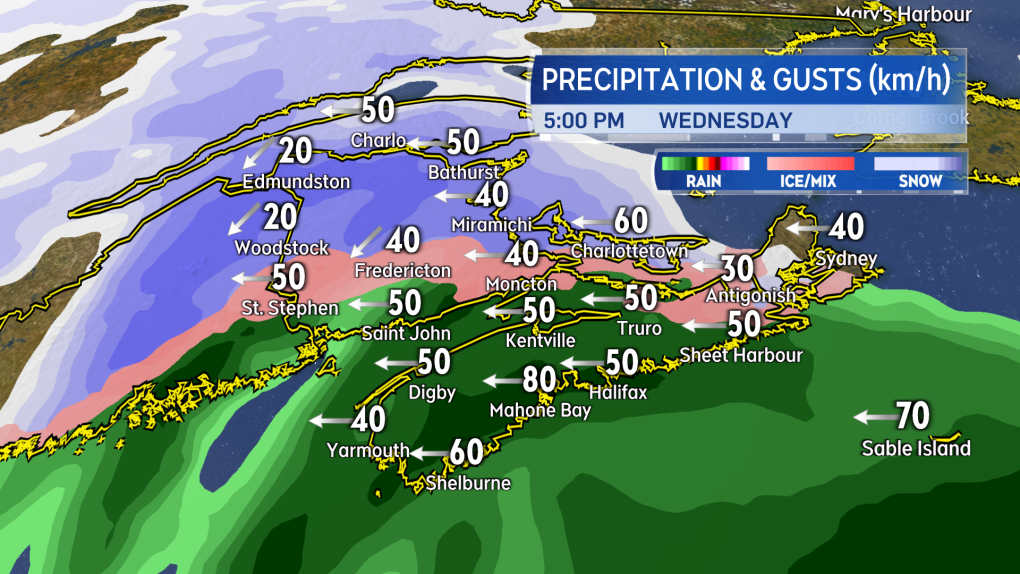
The mix of snow and rain will begin by noon on Wednesday in western New Brunswick and Nova Scotia. The precipitation will then increase in intensity and spread eastward Wednesday afternoon and evening. The snow and rain will clear eastern areas Thursday morning with a chance of flurries behind.

The snow and rain ramps up and develops west-to-east Wednesday noon into Wednesday evening.
The system will produce widespread gusts of 40 to 70 km/h out of the east and northeast by late Wednesday. Gusts may peak as high as 70 to 100 km/h on and near the Atlantic coastline of Nova Scotia, as well as inland in the east of the mainland and Cape Breton. Gusts in excess of 110 km/h are likely in northern Inverness County, Cape Breton Wednesday night and Thursday morning due to the topography of the Highlands. Those areas at risk of the higher gusts would of course also have an elevated risk of power outages.
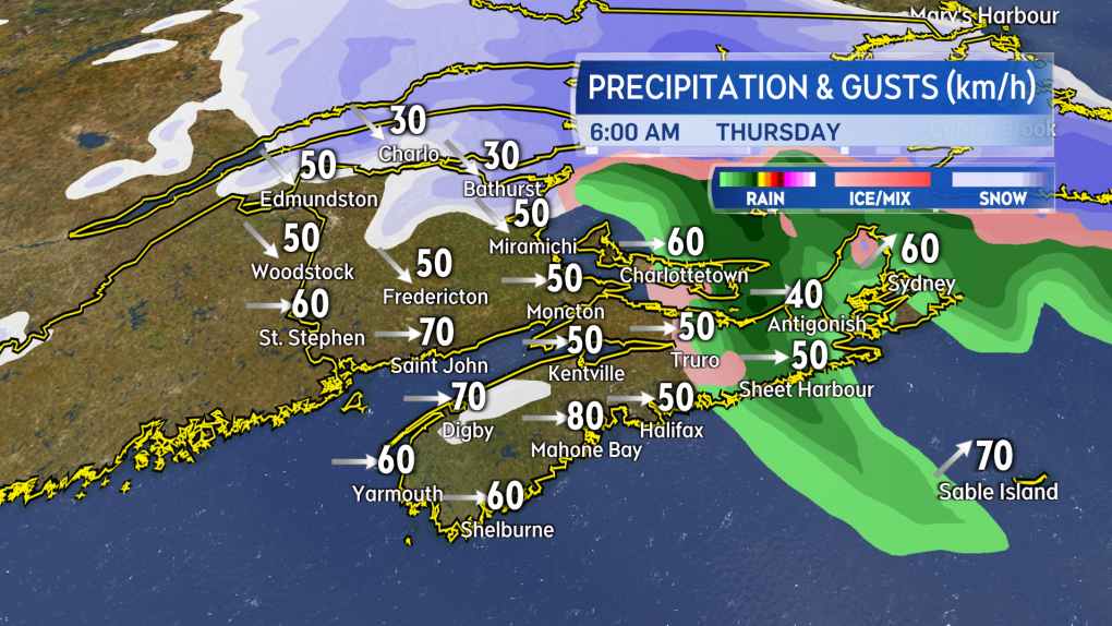
The wind will turn west and northwest Thursday morning. Widespread gusts of 40 to 60 km/h on Thursday, except peaks of 60 to 80 km/h for eastern areas including P.E.I. and Cape Breton.

Snow and rain clears eastward Thursday morning. The wind turns west and northwest and remains gusty through the day.
As of 4 p.m. Monday, Environment Canada issued Special Weather Statements for the entirety of the Maritimes advising the public to monitor the forecast and any future weather watches or warnings issued for the storm.
CTVNews.ca Top Stories

Justin Trudeau to step down as PM following Liberal leadership race
Prime Minister Justin Trudeau is stepping down as Liberal leader, and is proroguing Parliament as the Liberal Party of Canada embarks on the journey to replace him.
Trudeau resignation: recap key moments, analysis, reaction as it happened
Prime Minister Justin Trudeau has stepped down as Liberal leader. Here's a recap of key moments, analysis, and reaction as it happened.
Justin Trudeau steps down as Liberal leader. Who are the top contenders to replace him?
With Prime Minister Justin Trudeau's resignation as Liberal party leader, several well-known political faces may be waiting in the wings for their opportunity to take his place.
'Together, what a great nation it would be': Donald Trump, Elon Musk react to Justin Trudeau's resignation
Amid news of Prime Minister Justin Trudeau's resignation as leader of the Liberal party on Monday morning, reactions from prominent figures began piling in.
Trudeau says Parliament is 'prorogued' until March. What does that mean?
In his resignation speech on Monday, Prime Minister Justin Trudeau announced that Parliament would be prorogued until March, which will give the Liberal party time to find a new leader ahead of an expected confidence vote and early election.
Justin Trudeau is resigning, what will be his legacy? A look back at key political eras
In a seismic political move, Justin Trudeau has announced his intention to step down as leader of the Liberal Party of Canada and prime minister, once his successor is named. This decision comes after more than nine years in the country's top job and nearly 12 years at the helm of his party.
Justin Trudeau resignation: Here's what he said in Ottawa today
Prime Minister Justin Trudeau delivered a speech about his political future Monday morning outside Rideau Cottage in Ottawa. Here's the message he delivered to Canadians.
Alberta government signs new oil and gas agreement with Enbridge
The Alberta government has signed an agreement with Enbridge that Premier Danielle Smith says will increase exports of the province's heavy oil to the United States.
Trudeau leaves mixed global legacy as he exits during turbulent time, analysts say
Prime Minister Justin Trudeau will leave the world stage with a legacy of promoting feminist causes and focusing on Asia, along with criticism that Canada's actions fell short of the government's rhetoric.


