
HALIFAX -- A strengthening low-pressure system, moving out of the northeastern U.S., will wrap heavy moisture back into a pool of late season cold air centred over Quebec to bring a mix of rain and snow to the Maritimes Saturday.
Rain is expected to begin in the southwestern corners of New Brunswick and Nova Scotia overnight. The rain spreads quickly across Nova Scotia, southern New Brunswick, and P.E.I. by 9 a.m. on Saturday. Those areas seeing mainly rain can expect a general range of 15 to 30 mm.
Northern areas of New Brunswick will have to contend with a heavy, wet spring snow. There will be melting and compaction as it collects on the ground with total accumulation dependent on surface (more melting on pavement) and elevation (higher amounts at higher elevation).
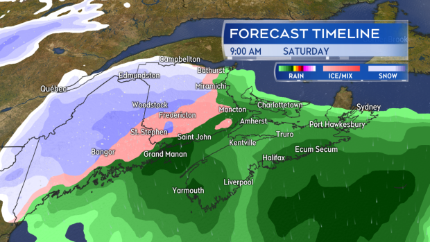
Rain, except snow for parts of western and northern New Brunswick, develops quickly Saturday morning.
The most snow is expected in a swath from Woodstock/Perth-Andover towards Bathurst and Miramichi, N.B. A widespread 10 to 20 cm is possible with the higher snowfall amounts most likely in the mountains and hills. The rain-snow line is expected to sink further south Saturday evening and night and may lead to some amounts during that time of five to 10 cm for Fredericton.
Other areas, including southern New Brunswick, Prince Edward Island, and inland areas of Nova Scotia, will see a turn to light snow in the early morning hours of Sunday. That will have possible amounts of one to five cm. Five to 10 cm looks likely in the Cape Breton Highlands through Sunday.
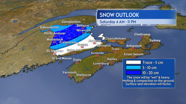
A swath of 10 to 20 cm of snow is expected in New Brunswick with accumulations impacted by surface and elevation.
Remaining showers and flurries will clear most of the Maritime region by Sunday afternoon, with the exception of Cape Breton where they will linger into the evening.
The system is also expected to bring about high and gusty winds. Nova Scotia, the Bay of Fundy coastline of N.B., and P.E.I. can expect southerly gusts to peak 40 to 70 km/h on Saturday. Gusts exceeding 110 km/h will be possible for Nova Scotia’s Inverness County Saturday evening into Sunday morning, due to the topography of the Highlands. Sunday will see a turn to westerly winds across the Maritimes with widespread gusts 50 to 80 km/h. Wind will gradually diminish Sunday evening and night.
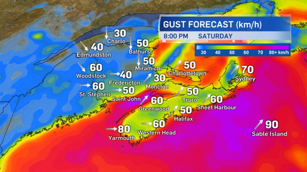
High and gusty southerly winds Saturday will turn westerly Sunday and remain strong, eventually easing Sunday evening and night.
Environment Canada has issued Snowfall Warnings across northern New Brunswick, with much of the rest of the Maritimes under a Special Weather Statement saying that some snow accumulation is possible before clearing on Sunday.
Takeaways:
- Rain develops Saturday morning. Expect a heavy, wet snow for northern areas of New Brunswick.
- Parts of western and northern New Brunswick will see totals of 10 to 20 cm.
- Areas that see mainly rain can expect 15 to 30 mm.
- The rain and snow eases to showers and flurries for Sunday, which eventually clears by and through the afternoon.
- High and gusty winds will develop as the system moves through. First southerly on Saturday, then turning westerly for Sunday with widespread gusts of 50 to 80 km/h.


