Kalin's call: Nor'easter expected to bring heavy snow to Maritimes this weekend
An area of low pressure originating off the coastline of Florida will merge with a cold front on Friday. The resulting storm will rapidly strengthen into a nor’easter, which will move north to impact the Maritimes Saturday into Sunday.
Much of the Maritimes will have to contend with a period of heavy snow with some areas turning through ice pellets to rain. High and gusty winds will create blowing snow and give a risk of power outages for some areas.
Special weather statements cautioning on the inclement weather have been issued by Environment Canada for all three Maritime provinces.
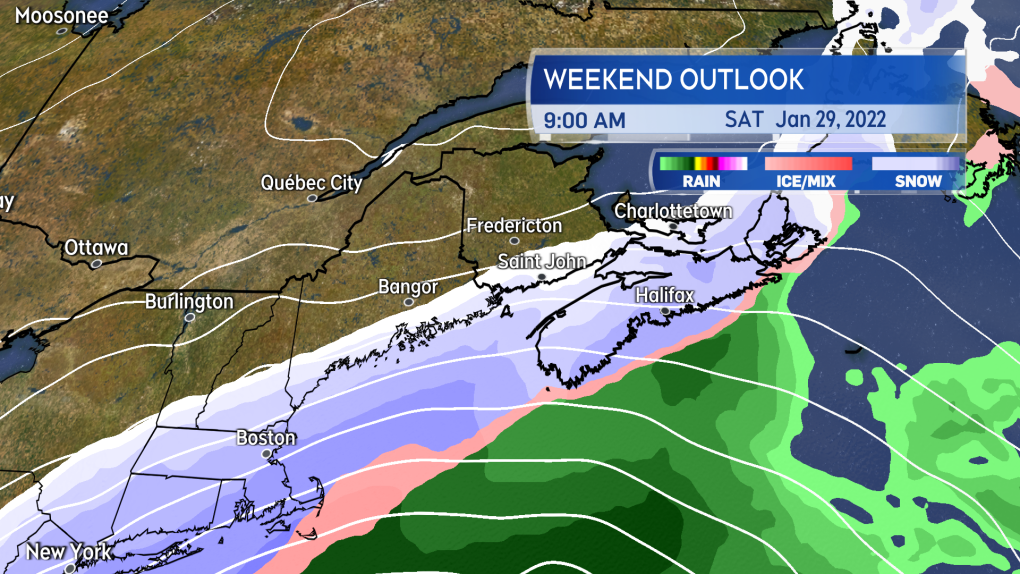
Heavy snow is expected to arrive in Nova Scotia Saturday morning, and will arrive Saturday afternoon for New Brunswick and P.E.I.
Heavy snow will develop Saturday morning for Nova Scotia, and will arrive Saturday afternoon for New Brunswick and Prince Edward Island.
By Saturday evening, much of Nova Scotia will have turned through a period of ice pellets to rain. P.E.I. can expect ice pellets and rain to mix in Saturday night. Snow will continue in New Brunswick into Sunday morning.
The mix of precipitation will clear the Maritimes through the day on Sunday. Temperatures will fall back below freezing for Nova Scotia and P.E.I. quickly on Sunday, with wet or slushy surfaces turning icy.
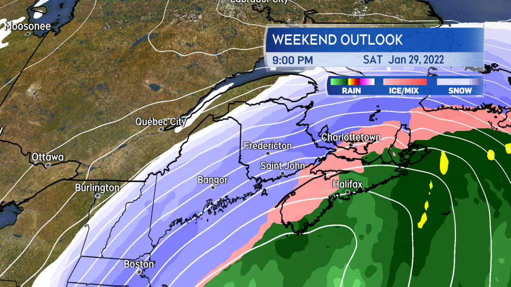
By Saturday evening, Nova Scotia will be in a mix of snow, ice pellets, and rain. Mixed precipitation is also likely for P.E.I. Saturday night.
In the above scenario, the most snow and ice pellet accumulation would be in western/northern Nova Scotia, southern/eastern New Brunswick, and P.E.I. Snowfall totals would diminish towards the Atlantic coastline and eastern areas of Nova Scotia with a quicker turn to rain.
Snowfall totals would diminish into northwestern New Brunswick being on the fringe of the storm. Areas experiencing the turn to rain would have a risk of localized flooding as the rain could total 10 to 40 mm and combine with snow melt.
Drainage systems may be blocked with snow and ice.
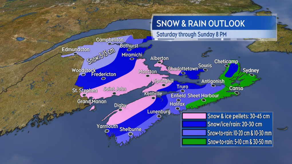
There is time for change, but as it stands western/northern Nova Scotia, southern/eastern New Brunswick, and P.E.I. are likely to see the highest snow totals.
A period of northeast and east winds peaking with gusts 60 to 90 km/h is likely Saturday afternoon into night. Where snow is falling heavily, visibility may be reduced to white-out conditions. Wind will turn westerly for Sunday and diminish through the day.
We are still sitting nearly three days out from the start of the storm. There is time to see significant change in the forecast. A pass of the system further east of the Atlantic coastline of Nova Scotia would result in an increase in the snow forecast for that province and lower totals for New Brunswick and P.E.I.
It is strongly recommended that you check frequently in on the weekend forecast through the end of this week.
CTV Chief Meteorologist Kalin Mitchell will have daily updates on the storm on CTV Atlantic news programs, as well as online.


CTVNews.ca Top Stories

'It could be catastrophic': Woman says natural supplement contained hidden painkiller drug
A Manitoba woman thought she found a miracle natural supplement, but said a hidden ingredient wreaked havoc on her health.
WATCH
WATCH Video shows dramatic police takedown of carjacking suspects chased through parking lot north of Toronto
Police have released video footage of a dramatic takedown of a group of teens wanted in connection with an attempted carjacking in Markham earlier this month.
After hearing thousands of last words, this hospital chaplain has advice for the living
Hospital chaplain J.S. Park opens up about death, grief and hearing thousands of last words, and shares his advice for the living.
DEVELOPING
DEVELOPING G7 warns of new sanctions against Iran as world reacts to apparent Israeli drone attack
Group of Seven foreign ministers warned of new sanctions against Iran on Friday for its drone and missile attack on Israel, and urged both sides to avoid an escalation of the conflict.
WHO likely to issue wider alert on contaminated cough syrup
The World Health Organization is likely to issue a wider warning about contaminated Johnson and Johnson-made children's cough syrup found in Nigeria last week, it said in an email.
Advocacy groups speak out against domestic violence comments by Nova Scotia minister
Several Nova Scotia groups that assist women are speaking out against comments on domestic violence by Justice Minister Brad Johns, and at least one is calling for his dismissal.
A couple lost their wedding rings during the ceremony. Two strangers found a fitting solution
Every good wedding has to have one teensy, tiny crisis.
'It was all my savings': Ontario woman loses $15K to fake Walmart job scam
A woman who recently moved to Canada from India was searching for a job when she got caught in an online job scam and lost $15,000.
Families to receive Canada Child Benefit payment on Friday
More money will land in the pockets of some Canadian families on Friday for the latest Canada Child Benefit installment.
Shopping Trends
The Shopping Trends team is independent of the journalists at CTV News. We may earn a commission when you use our links to shop. Read about us.


Toronto
-
 WATCH
WATCHWATCH Video shows dramatic police takedown of carjacking suspects chased through parking lot north of Toronto
Police have released video footage of a dramatic takedown of a group of teens wanted in connection with an attempted carjacking in Markham earlier this month.
-
TTC service could be disrupted Monday if electrical and trades strike, CEO warns
The head of the TTC is warning of possible impacts to service on Monday if the union representing a group of more than 650 electrical and trades workers moves ahead with a strike.
-
'It was all my savings': Ontario woman loses $15K to fake Walmart job scam
A woman who recently moved to Canada from India was searching for a job when she got caught in an online job scam and lost $15,000.
Calgary
-
Voluntary water limits put in place in face of possible Alberta drought
More than three dozen of Alberta's largest water users have agreed with a provincial plan to cut down this year ahead of a severe drought expected this summer.
-
Calgary mayor and council 'incredibly focused' on rezoning plan
Calgary’s blanket rezoning plan is one of the most contentious issues to face the city in recent years, with a public hearing starting Monday morning.
-
City of Calgary to respond to Alberta water-sharing announcement
The City of Calgary is going to provide an update on its drought preparedness plan and respond to the province’s water-sharing agreements on Friday.
Edmonton
-

Oilers host Los Angeles Kings on Monday in Game 1 of playoffs
The National Hockey League has confirmed the schedule for the first four Edmonton Oilers playoff games.
-
Voluntary water limits put in place in face of possible Alberta drought
More than three dozen of Alberta's largest water users have agreed with a provincial plan to cut down this year ahead of a severe drought expected this summer.
-
Worker dies after fall at north Edmonton construction site
Occupational Health and Safety (OHS) is investigating after a worker fell to their death earlier this week.
Montreal
-

American millionaire Jonathan Lehrer denied bail after being charged with killing Canadian couple
American millionaire Jonathan Lehrer, one of two men charged in the killings of a Canadian couple in Dominica, has been denied bail.
-
Stabbing at Montreal motel leaves woman seriously injured
A woman's life is in danger after a stabbing at a motel in Montreal.
-
Longueuil lifts boil water advisory for Saint-Hubert, alert remains in effect in Saint-Bruno-de-Montarville
The City of Longueuil has lifted its boil water advisory for the borough of Saint-Hubert.
Ottawa
-

Gatineau, Que. teen accused of using social media to harass victim
A 13-year-old Gatineau, Que. boy is facing charges, including criminal harassment and distribution of child pornography, after allegedly using social media to harass the victim, according to police.
-
OPP reminds drone operators it's illegal to operate a drone near emergency sites following Hwy. 417 fatal crash
Ontario Provincial Police are reminding people that it is illegal to fly a drone over traffic collision sites, after drone footage captured over a fatal crash on Hwy. 417 in Ottawa appeared online.
-
Ontario man wanted after breaching 'statutory release'
The Repeat Offender Parole Enforcement Squad is asking the public for help locating a man in Ontario wanted on a Canada Wide Warrant after breaching their “statutory release.”
London
-

Two people arrested in Port Elgin after vehicle theft in Hanover
Police in Hanover and Saugeen Shores have made an arrest after a citizen recognized a stolen vehicle from a social media post.
-
Human trafficking-related charges laid by London police
London police have charged a man from Manitoba with human trafficking-related charges. Police in the 600 block of Wellington Rd. near Wilkins Street when they saw a vehicle with stolen plates in a parking lot.
-
Crash causes power outage in St. Thomas
According to police, there was “significant damage” to the hydro pole, causing a power outage to the surrounding areas.
Barrie
-

Break-in leaves Barrie home with considerable water damage
Police are hoping to identify the person(s) who allegedly broke into a Barrie home and caused extensive water damage.
-
Serious rollover on Highway 400 sends mother to hospital
Person airlifted to Toronto after a rollover on Highway 400 Friday morning.
-
Clock ticking on CAA's Worst Roads campaign
CAA's Worst Roads campaign ensures municipalities know which roads its residents feel need rapid improvement.
Northern Ontario
-

Sudbury police investigating threat found in high school bathroom stall
Sudbury police will have an increased presence at a local high school after two threatening messages were found in a bathroom stall.
-
Driver suffered medical emergency in fatal Highway 17 crash
One person has died as the result of a single-vehicle crash at a northern Ontario business on Highway 17 on Thursday afternoon, police say.
-
Northern Ont. man fined after decoy operation catches him hunting on private property
A Thunder Bay man has been fined $2,000 after he was caught in a decoy operation hunting on private land.
Kitchener
-
Landlords reporting increase in tenants refusing to pay rent or leave
A property management company in Fergus is still cleaning up after they say a tenant trashed one of their units and refused to pay rent -- and they say it's not the only similar case they've dealt with recently.
-
Strange beasts stalking Silver Lake in Waterloo
Don’t be alarmed if you see some strange new creatures in Waterloo Park.
-
Ontario Review Board considers future of Kitchener man who killed wife, blew up home
An Ontario Review Board hearing was held at the Southwest Centre for Forensic Mental Health Care in St. Thomas on Thursday to consider the future of Udo Haan.
Windsor
-

Body recovered from Detroit River
An investigation is underway after a body was pulled from the Detroit River.
-
City of Windsor flunks fiscal transparency in new report
A new report from the C.D. Howe Institute puts the City of Windsor at the bottom of the list for fiscal transparency.
-
Police in Windsor looking for Ramtin Bayat
Windsor police are asking the public to keep an eye out for a man last seen in the downtown area.
Winnipeg
-
'It could be catastrophic': Woman says natural supplement contained hidden painkiller drug
A Manitoba woman thought she found a miracle natural supplement, but said a hidden ingredient wreaked havoc on her health.
-
Winnipeg Jets release Round 1 playoff schedule
The Winnipeg Jets have released its first round playoff schedule.
-
WINSAR members ready to answer the call for missing persons
In southern Manitoba, members of Winnipeg Search and Rescue (WINSAR) remain vigilant as they assist in finding a missing Manitoban.
Regina
-

New crash course focused on getting Sask. youth excited about journalism
Fifteen youth from a variety of backgrounds are taking on the monumental task of creating and performing a live radio broadcast with on seven days to prepare. The goal of the project is to get more youth excited about journalism.
-
SaskPower investing $13.5M in Regina's downtown electrical grid
SaskPower says it will be investing $13.5 million in an effort to improve downtown Regina's electrical grid.
-
'Opening soon': Highly anticipated return of Taco Bell to Regina approaching
Many in Regina have been waiting for Taco Bell's return to the Queen City since news of a return first broke in January 2023, an exact opening date isn't widely known yet, but it will be 'opening soon.'
Saskatoon
-

Saskatoon police committing three officers to curb crime in Pleasant Hill
The Saskatoon Police Service (SPS) is dedicating three officers to a specialized unit to help curb crime in the Pleasant Hill neighbourhood.
-
New Sask. dental hygienist degree program to offer strictly evening classes
A new dental hygienist degree program is launching at the University of Saskatchewan (U of S) in September to help meet a growing demand for oral health specialists.
-
Travel not recommended on several Sask. highways Friday morning
As a 'Colorado hybrid' system continues to bring snow and gusty winds to parts of Saskatchewan, highway conditions have continued to deteriorate over the past 48 hours.
Vancouver
-
Coroner's inquest called into death of man killed in police shootout in Kamloops, B.C.
The British Columbia government has called for a coroner's inquest into the death of a 35-year-old Kamloops man who was killed in a shootout with police nearly six years ago.
-
Vancouver Canucks release round 1 schedule against Nashville Predators
It's been nine long years since the Vancouver Canucks have played an NHL playoff game at Rogers Arena and fans are ready to see this season's Pacific Division champions take on the Nashville Predators.
-
Off-duty Mountie cleared of wrongdoing after cyclist seriously injured in Langford, B.C.
British Columbia's police watchdog has cleared an off-duty Mountie of wrongdoing after a cyclist suffered serious injuries in a collision with an unmarked police vehicle last month.
Vancouver Island
-

Off-duty Mountie cleared of wrongdoing after cyclist seriously injured in Langford, B.C.
British Columbia's police watchdog has cleared an off-duty Mountie of wrongdoing after a cyclist suffered serious injuries in a collision with an unmarked police vehicle last month.
-
Coroner's inquest called into death of man killed in police shootout in Kamloops, B.C.
The British Columbia government has called for a coroner's inquest into the death of a 35-year-old Kamloops man who was killed in a shootout with police nearly six years ago.
-
Vancouver Canucks release round 1 schedule against Nashville Predators
It's been nine long years since the Vancouver Canucks have played an NHL playoff game at Rogers Arena and fans are ready to see this season's Pacific Division champions take on the Nashville Predators.
Kelowna
-

Stolen snake named Milkshake returned to Kelowna pet store
A banana ball python that was stolen from a Kelowna pet store on Saturday has been returned unharmed, Mounties said.
-
Nurses rally at B.C. Interior hospital over security, staffing concerns
Nurses held a rally Wednesday at a hospital in the B.C. Interior that closed its emergency department more than a dozen times last year due to insufficient staff.
-
B.C. to add 240 complex-care housing units throughout province
British Columbia is planning to add 240 new units to its complex-care housing program, providing homes for people with mental-health and addictions challenges that overlap with other serious conditions.


