Kalin's call: Nor'easter expected to bring heavy snow to Maritimes this weekend
An area of low pressure originating off the coastline of Florida will merge with a cold front on Friday. The resulting storm will rapidly strengthen into a nor’easter, which will move north to impact the Maritimes Saturday into Sunday.
Much of the Maritimes will have to contend with a period of heavy snow with some areas turning through ice pellets to rain. High and gusty winds will create blowing snow and give a risk of power outages for some areas.
Special weather statements cautioning on the inclement weather have been issued by Environment Canada for all three Maritime provinces.
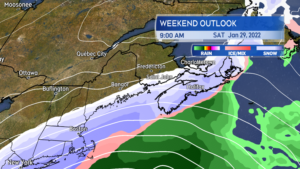
Heavy snow is expected to arrive in Nova Scotia Saturday morning, and will arrive Saturday afternoon for New Brunswick and P.E.I.
Heavy snow will develop Saturday morning for Nova Scotia, and will arrive Saturday afternoon for New Brunswick and Prince Edward Island.
By Saturday evening, much of Nova Scotia will have turned through a period of ice pellets to rain. P.E.I. can expect ice pellets and rain to mix in Saturday night. Snow will continue in New Brunswick into Sunday morning.
The mix of precipitation will clear the Maritimes through the day on Sunday. Temperatures will fall back below freezing for Nova Scotia and P.E.I. quickly on Sunday, with wet or slushy surfaces turning icy.
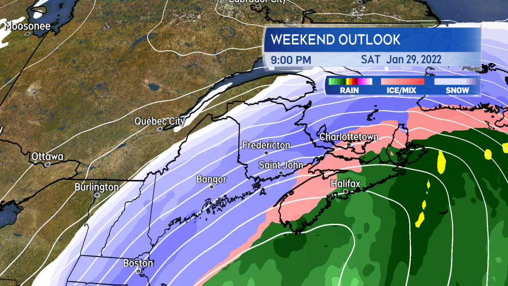
By Saturday evening, Nova Scotia will be in a mix of snow, ice pellets, and rain. Mixed precipitation is also likely for P.E.I. Saturday night.
In the above scenario, the most snow and ice pellet accumulation would be in western/northern Nova Scotia, southern/eastern New Brunswick, and P.E.I. Snowfall totals would diminish towards the Atlantic coastline and eastern areas of Nova Scotia with a quicker turn to rain.
Snowfall totals would diminish into northwestern New Brunswick being on the fringe of the storm. Areas experiencing the turn to rain would have a risk of localized flooding as the rain could total 10 to 40 mm and combine with snow melt.
Drainage systems may be blocked with snow and ice.
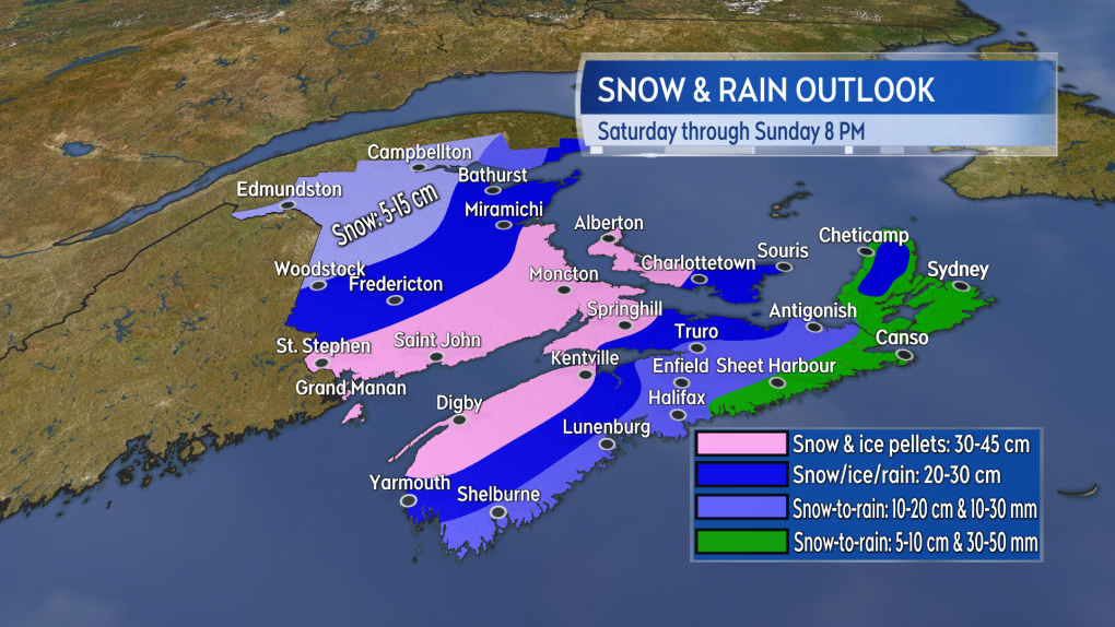
There is time for change, but as it stands western/northern Nova Scotia, southern/eastern New Brunswick, and P.E.I. are likely to see the highest snow totals.
A period of northeast and east winds peaking with gusts 60 to 90 km/h is likely Saturday afternoon into night. Where snow is falling heavily, visibility may be reduced to white-out conditions. Wind will turn westerly for Sunday and diminish through the day.
We are still sitting nearly three days out from the start of the storm. There is time to see significant change in the forecast. A pass of the system further east of the Atlantic coastline of Nova Scotia would result in an increase in the snow forecast for that province and lower totals for New Brunswick and P.E.I.
It is strongly recommended that you check frequently in on the weekend forecast through the end of this week.
CTV Chief Meteorologist Kalin Mitchell will have daily updates on the storm on CTV Atlantic news programs, as well as online.


CTVNews.ca Top Stories

Outdated cancer screening guidelines jeopardizing early detection, doctors say
A group of doctors say Canadian cancer screening guidelines set by a national task force are out-of-date and putting people at risk because their cancers aren't detected early enough.
Mussolini's wartime bunker opens to the public in Rome
After its last closure in 2021, it has now reopened for guided tours of the air raid shelter and the bunker. The complex now includes a multimedia exhibition about Rome during World War II, air raid systems for civilians, and the series of 51 Allied bombings that pummeled the city between July 1943 and May 1944.
'I just started crying': Blue Jays player signs jersey for man in hospital
An Ontario woman says she never expected to be gifted a Blue Jays jersey for her ailing husband when she sat alone at the team’s home opener next to a couple of kind strangers.
LIVE @ 4 EDT
LIVE @ 4 EDT Freeland to present 2024 federal budget, promising billions in new spending
Canadians will learn Tuesday the entirety of the federal Liberal government's new spending plans, and how they intend to pay for them, when Deputy Prime Minister and Finance Minister Chrystia Freeland tables the 2024 federal budget.
B.C. woman facing steep medical bills, uncertain future after Thailand crash
The family of a Victoria, B.C., woman who was seriously injured in an accident in Thailand is pleading for help as medical bills pile up.
Step inside 'The Brain': Northern education tool aims to promote drug safety
An immersive experience inside a massive dome coined 'The Brain' is helping youth learn about brain function and addiction
WATCH
WATCH Half of Canadians living paycheque-to-paycheque: Equifax
As Canadians deal with a crushing housing shortage, high rental prices and inflationary price pressures, now Equifax Canada is warning that Canadian consumers are increasingly under stress"from the surging cost of living.
Ontario woman charged almost $7,000 for 20-minute taxi ride abroad
An Ontario woman was shocked to find she’d been charged nearly $7,000 after unknowingly using an unauthorized taxi company while on vacation in January.
Inmate who escaped from N.B. prison has long history of violent crimes
An inmate who escaped from Dorchester Penitentiary in Dorchester, N.B., on Saturday evening has a long history of violent crimes and a history of escaping custody.
Shopping Trends
The Shopping Trends team is independent of the journalists at CTV News. We may earn a commission when you use our links to shop. Read about us.


Toronto
-

Suspicious package delivered to Queen’s Park determined to be gravy: police
A suspicious package delivered to Queen’s Park on Thursday was determined to be a package of powdered gravy, police say.
-
'I just started crying': Blue Jays player signs jersey for man in hospital
An Ontario woman says she never expected to be gifted a Blue Jays jersey for her ailing husband when she sat alone at the team’s home opener next to a couple of kind strangers.
-
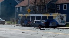
Teens crash stolen vehicle into parked car moments after alleged GTA carjacking
Police say a group of teens are facing charges after they allegedly stole a vehicle at gunpoint in a Markham parking lot but crashed it into a parked car just moments later.
Calgary
-

Canada Pension Plan investment board to host public meeting in Calgary
The Canada Pension Plan (CPP) investment board will be hosting a public meeting from 6 to 8 p.m. on April 16 at the BMO Centre.
-
WEATHER
WEATHER Heavy, wet snow blankets Calgary, warmup not expected until Sunday
As expected, a frontal system brought rain to southern Alberta, then heavy, wet snow into the region late Monday and early Tuesday.
-
Deadmau5, DJ Snake and 'Vanderpump' star James Kennedy among 2024 Chasing Summer performers
A bunch of big-name DJs are set to perform in Calgary in August at the 2024 Chasing Summer music festival, including one that reality TV lovers might be excited about.
Edmonton
-

Ice District watch parties return for Oilers playoffs
The Edmonton Oilers are bringing back watch parties inside and outside Rogers Place when the Stanley Cup Playoffs begin in the coming days.
-
Tickets issued after large, unleashed dog spotted in front of home where boy was killed by dogs
Two tickets were issued after an unleashed dog was seen in front of a home where a boy died in a dog attack earlier this month.
-
Tamarack Valley shuts Alberta output after gas plant fire
Canada's Tamarack Valley Energy TVE.TO has temporarily shut production of about 6,200 barrels of oil equivalent per day (boepd) following a fire at a Canadian Natural Resources Ltd CNQ.TO gas plant in Alberta, the companies said on Monday.
Montreal
-

Quebec court approves class action alleging opioid makers misled users about risks
A Quebec Superior Court judge has authorized a class-action lawsuit against 16 pharmaceutical companies that are alleged to have misled consumers about the efficacy and dangers of opioid medications.
-
Recycling Montreal's Olympic Stadium roof: international competition collects bids
An international competition is hoping to gather new and interesting ways to recycle Montreal's Olympic Stadium roof, which is set to be dismantled this summer.
-
NHL clears Canadiens defenceman Logan Mailloux ahead of season finale
The NHL says it has cleared Logan Mailloux for participation after the Montreal Canadiens recalled the defenceman Monday night ahead of their regular-season finale Tuesday.
Ottawa
-
 LIVE @ 4 EDT
LIVE @ 4 EDT Freeland to present 2024 federal budget, promising billions in new spending
Canadians will learn Tuesday the entirety of the federal Liberal government's new spending plans, and how they intend to pay for them, when Deputy Prime Minister and Finance Minister Chrystia Freeland tables the 2024 federal budget.
-
Thousands of dollars worth of tropical fish stolen from Ottawa Valley restaurant
Ontario Provincial Police are investigating the theft of "several thousand" dollars worth of tropical fish stolen from an Upper Ottawa Valley restaurant last week.
-
Charges laid against 2 in series of Ottawa jewelry store thefts
Ottawa police have charged two people allegedly responsible for seven jewelry store thefts and robberies in the last year.
London
-
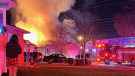
As 'bright as the sun': Students describe house fire near Fanshawe College
A number of students have been displaced after a house fire in east London near Fanshawe College. Crews were called to the scene on Prosperity Court late Monday night.
-
Converting office space into affordable housing in downtown London
Sifton Properties, Homes Unlimited (London) and the Anglican Diocese of Huron and St. Paul's Cathedral will be working together on the conversion of an office building to affordable housing.
-
Traffic coming to a crawl on Main Street Exeter
Construction will slow down traffic moving through Exeter for the rest of the year. A reconstruction of the community's main street at the north end of town is underway.
Barrie
-

Woman plans for vacation and a new home after winning $1M lottery prize
A woman from Alliston will take home a $1 million lottery prize after matching all seven Encore numbers in the exact order on the March 6 draw.
-
Casino Rama adds new shows to its 2024 performance lineup
Two new shows are coming to Casino Rama's Entertainment Centre for fans of country music and 80s rock.
-
Stolen truck and trailer found abandoned after break-in at Barrie compound
Police in Barrie are investigating a bizarre theft after a suspect broke into a fenced compound, stole a pickup truck and trailer and plowed through the locked gate before abandoning both stolen items.
Northern Ontario
-

Northern Ont. driver missing after vehicle pulled into creek
Rescue crews are searching for a man reported missing on the weekend after the vehicle he was driving was pulled into a creek near the Quebec border in northern Ontario.
-
Ontario woman charged almost $7,000 for 20-minute taxi ride abroad
An Ontario woman was shocked to find she’d been charged nearly $7,000 after unknowingly using an unauthorized taxi company while on vacation in January.
-
Northern Ont. man acquitted of murder on James Bay coast
A northern Ontario family is devastated after a jury found a Moose Factory man not guilty of a 2021 murder.
Kitchener
-

Driveway paving scammers reported in Waterloo Region
Cambridge resident Samantha Falkiner explains why something felt "off" about the men who approached her and her neighbours on Friday.
-
Policing costs for St. Patrick’s Day celebrations in Waterloo increased by $51,000
Waterloo Regional Police Services has released the estimated total cost for the St. Patrick’s Day weekend in the city of Waterloo.
-
Swans return to Victoria Park
The sun is shining and the swans are back in the water at Victoria Park in Kitchener.
Windsor
-

'He’s done great things': incarcerated Windsorite works to make prison more culturally sensitive for fellow inmates
The ‘faint hope’ hearing of Ali Al-Shammari, 38, continued Tuesday in Superior court.
-
Woman arrested in Walkerville porch pirate investigation
Windsor police have arrested a 35-year-old woman related to a porch pirate investigation in Walkerville.
-
Hillman Marsh prepared to celebrate birding season
The Essex Region Conservation Authority is preparing for an influx of birders migrating to the region to snap, track and catch glimpses of special species in Leamington.
Winnipeg
-

12-year-old girl finds shotgun on Manitoba beach
Police are investigating after a 12-year-old girl found a sawed-off shotgun on the shores of a Manitoba beach.
-
Manitoba Progressive Conservatives to elect new leader in April 2025
Manitoba Progressive Conservatives are to select a new leader on April 26 of next year.
-
Manitoba NDP raised and spent more money than the Tories in the election campaign
New figures show Manitoba New Democrats raised and spent more money than the Progressive Conservatives in last year's election campaign.
Regina
-
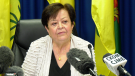
'Puppet show': Saskatchewan finance minister apologizes for text to Speaker
Saskatchewan's finance minister was ordered to apologize after she sent the Speaker a text accusing him of letting the legislature devolve into an 'Opposition puppet show' on Monday.
-
Not just flat: What tourism means to Saskatchewan
In Saskatchewan tourism generates over $2.4 billion in yearly spending and employs close to 71,000 people.
-
Sask. real estate company that lost investors' millions reaches settlement
The founders of a Saskatoon real estate investment company that left investors with millions of dollars in losses have reached a settlement with Saskatchewan’s financial and consumer watchdog.
Saskatoon
-

Sask. real estate company that lost investors' millions reaches settlement
The founders of a Saskatoon real estate investment company that left investors with millions of dollars in losses have reached a settlement with Saskatchewan’s financial and consumer watchdog.
-
Saskatoon Muslim community mourns teen killed in high-speed crash
Friends are raising money for the grieving family of a 16-year-old Saskatoon boy who was killed in a high-speed crash that injured two other teens on Sunday morning.
-
Saskatoon police investigating second homicide this week
Saskatoon Police Service (SPS) are investigating the second homicide this week after a 25-year-old man was fatally shot early Tuesday morning.
Vancouver
-

Burnaby man charged with murder in South Vancouver stabbing
Vancouver police say a 29-year-old man has been charged with second-degree murder in the targeted killing of a 49-year-old woman in South Vancouver.
-
Rangers seize tents from CRAB Park in 'sweep and scatter' effort, advocates say
Vancouver park rangers enforced the removal of several tents from CRAB Park Tuesday morning in what advocates decried as a "sweep and scatter" effort to displace more homeless campers.
-
Suspect arrested after alleged assault on Vancouver officer at pro-Palestinian protest
Authorities have arrested a suspect who allegedly assaulted a Vancouver police officer during a pro-Palestinian protest last month.
Vancouver Island
-

Planning next bid to rescue B.C. orca calf will take 'few days': Fisheries Department
The Department of Fisheries says planning for a new attempt to rescue an orca calf trapped in a Vancouver Island lagoon will be finalized in the next few days but no date has been set.
-
B.C. woman facing steep medical bills, uncertain future after Thailand crash
The family of a Victoria, B.C., woman who was seriously injured in an accident in Thailand is pleading for help as medical bills pile up.
-
Burnaby man charged with murder in South Vancouver stabbing
Vancouver police say a 29-year-old man has been charged with second-degree murder in the targeted killing of a 49-year-old woman in South Vancouver.
Kelowna
-

B.C. to add 240 complex-care housing units throughout province
British Columbia is planning to add 240 new units to its complex-care housing program, providing homes for people with mental-health and addictions challenges that overlap with other serious conditions.
-
Evacuation of Kelowna, B.C., apartment near construction site extended for two weeks
More than 80 residents from a low-income apartment building in Kelowna, B.C., have learned they won't be able to return to their homes for at least another two weeks.
-
2 men injured after 'road rage' incident with Dodge Ram driver, Kelowna RCMP say
Mounties are investigating a reported "road rage" incident in Kelowna, B.C., that left two men injured last week.


