Kalin's Call: Rapidly strengthening low-pressure system crosses the Maritimes late Saturday
A rapidly strengthening low-pressure system will cross the Maritimes late Saturday before moving north towards Labrador.
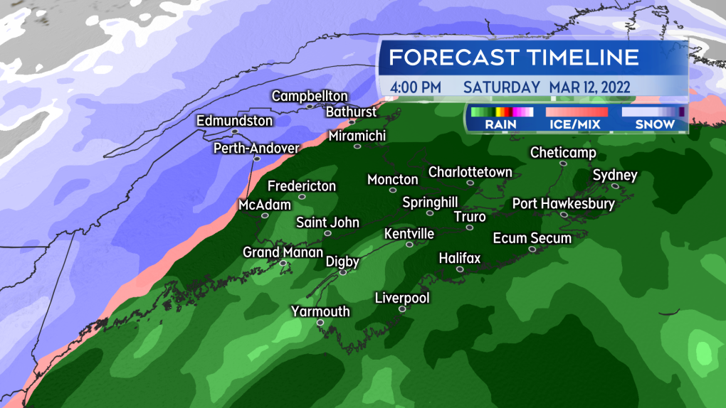
Rain will develop across most of the region Saturday morning into the afternoon, with the northwestern corner of New Brunswick seeing heavy snow.
The precipitation will be heaviest late Saturday afternoon through evening. There will be some areas of flurries in a colder westerly wind in the wake of Sunday’s system.
 Rain will develop for most of the region Saturday morning and afternoon. Snow in northwestern New Brunswick.
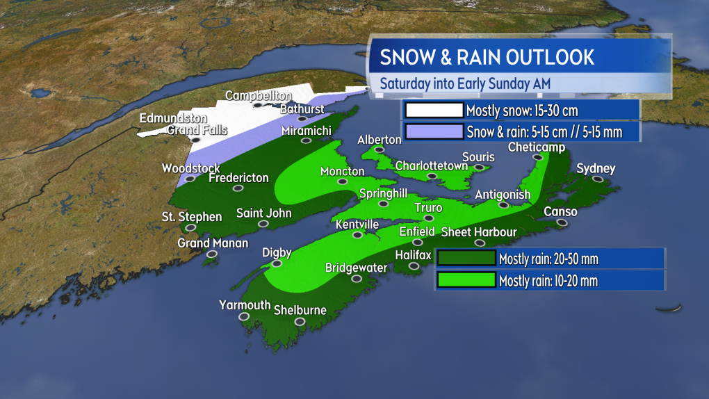
Fairly widespread rain is forecasted with amounts ranging between 20 to 50 mm. Localized flooding may result from a combination of high rainfall rates, melting snow, and blocked drainage systems.
Snow looks likely for the northwestern corner of New Brunswick with amounts between 15 to 30 cm. Even Woodstock in the west of New Brunswick and Bathurst in the northeast could finish with a snowfall of five to 15 cm as quickly falling temperatures Saturday evening, turns rain back to snow before it clears.
On a travel note, the Trans-Canada Highway runs through an area of New Brunswick that could see some significant snow. Additionally, portions of that highway will also be affected by heavy snow from the storm in Quebec Saturday.
 A widespread 20 to 50 mm of rain is expected, with heavy snow in northern areas of New Brunswick.
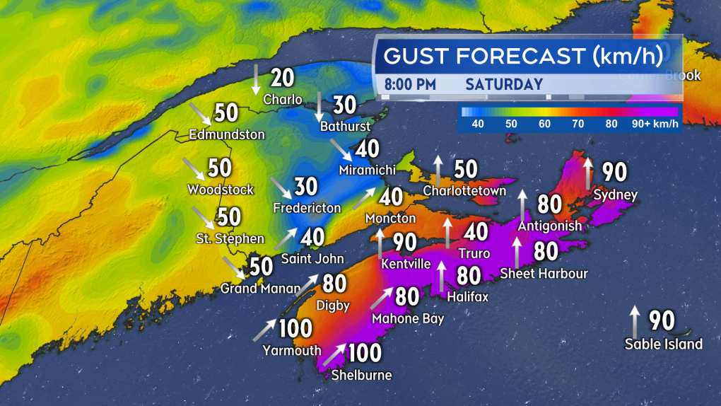
Two peaks of wind can be expected with the storm. The first coming Saturday evening and night when the Bay of Fundy area of New Brunswick, Nova Scotia, and Prince Edward Island will experience southerly gusts 70 to 110 km/h.
Gusts are likely to exceed 110 km/h in northern Inverness County, Cape Breton, due to the topography of the Highlands. The strongest gusts are most likely on exposed areas of the coast, and on higher terrain.
 Strong southerly gusts peaking 70 to 110 km/h will develop Saturday evening for parts of southern New Brunswick, Nova Scotia, and Prince Edward Island. The strongest gusts most likely on exposed areas of the coast and higher terrain.
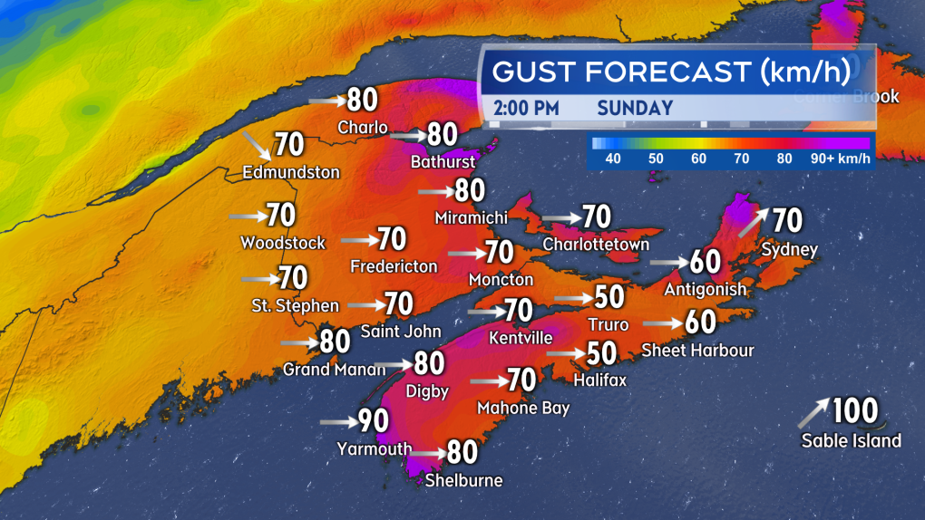
The second peak of wind comes Sunday with west and northwest winds gusting between 50 to 80 km/h until mid-to-late evening. Exposed areas of the coastlines could peak with gusts near 90 km/h on Sunday.
Some power outages are often associated with winds that strong. Wind may also disrupt marine travel routes. Marine Atlantic has already posted an advisory stating they expect sailings to be impacted this weekend. Bay Ferries Limited has also canceled some sailings between Digby, NS and Saint John N.B.
 Widespread 50 to 80 km/h gusts on Sunday. The wind direction will be west/northwest and colder as result.
Environment Canada has issued a number of weather warnings for the storm. These include rainfall and snowfall warnings in New Brunswick and rainfall and wind warnings in Nova Scotia.
CTVNews.ca Top Stories

BREAKING Quebec police issue Amber Alert for nine-year-old child
Quebec provincial police have issued an Amber Alert for a missing nine-year-old child.
Elon Musk calls Justin Trudeau 'insufferable tool' in new social media post
Billionaire Elon Musk is calling Prime Minister Justin Trudeau 'an insufferable tool' in a new social media post on Wednesday. 'Won't be in power for much longer,' Musk also wrote about the prime minister on 'X.'
Banks lower prime rates following Bank of Canada move
Canadian financial institutions are lowering their prime lending rates to match the decrease announced by the Bank of Canada.
Police locate labyrinth of tunnels connecting tents to generator in Hamilton encampment
Hamilton police say that they discovered a series of “man-made holes and tunnels” during a patrol of a downtown encampment earlier this week.
Trudeau will have to 'kiss the ring' to achieve smoother bilateral relations with Trump: John Bolton
If Prime Minister Justin Trudeau wants to get on U.S. president-elect Donald Trump's good side for the sake of a smooth bilateral relationship, he'll likely have to be openly deferential, says former U.S. National Security Advisor, John Bolton.
Police identify murder victim whose skull was found in Ontario river more than three decades ago
Police have identified a man whose skull was found almost 40 years ago in a Peterborough-area river.
Certain foods may disrupt your body's fight against cancer cells, study says
The food you eat may be affecting your body’s ability to fight cancer cells in the colon, according to a new study.
Canada Post strike: Talks deadlocked as sides clash on wages
Negotiations between Canada Post and the union representing its workers appear to be in a deadlock as the two sides remain far apart on wages and other issues.
Poilievre's Conservatives still in majority territory: Nanos seat projections
The Liberals' promise of a temporary GST break and $250 rebate cheques haven't benefited Prime Minister Justin Trudeau and his minority government when it comes to public support, according to Nanos Research data.


