
HALIFAX -- A strengthening low-pressure system will move across Nova Scotia and into southwestern New Brunswick Tuesday into Wednesday morning.
A wintry mix of weather will build slowly across the Maritimes ahead of and throughout this low-pressure system.
The concern for Monday evening and night will be for icy or slick surfaces developing as a light mix of snow and freezing rain spreads across Nova Scotia, southern New Brunswick, and Prince Edward Island. For these areas there will be a risk of freezing rain Tuesday morning before a turn to rain moving into the afternoon.
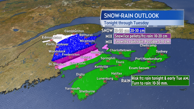
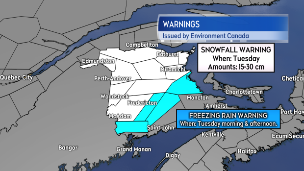
Central New Brunswick will experience a more prolonged period of snow, ice pellets, and freezing rain on Tuesday, while northern areas of New Brunswick will see mainly snow. From Fredericton and extending northward across the province, there are expected to be some fairly widespread totals of 15 to 30 cm in the mix of snow and ice pellets. South of Fredericton, the snow amounts will taper lower towards the Bay of Fundy coastline as more freezing rain and rain will be present. Both snowfall and freezing rain warnings have been issued for large areas of New Brunswick by Environment Canada.
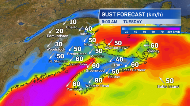
Gusty northeast winds will develop tonight and be present on Tuesday. Peak inland gusts will reach 30 to 60 km/h while coastal gusts will range between 50 to 80 km/h. The winds will turn northwest and gradually diminish Tuesday night and Wednesday morning.
The remaining mix of snow and rain will clear Tuesday night and Wednesday morning. The back edge of the rain may turn back to brief period of snow for southern New Brunswick, Prince Edward Island, and Nova Scotia as this happens. Should that happen, some slippery surfaces may develop for those areas for Wednesday morning.


