Kalin's Call: Weather warnings issued ahead of late week storm

A nor’easter is still anticipated to have a significant impact on much of the Maritimes late Friday into Saturday.
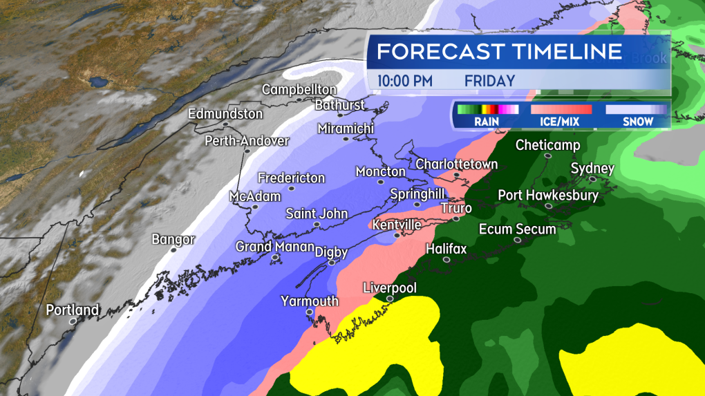
Weather conditions deteriorate heading into Friday evening and night. Heavy snow, ice pellets, and rain combine with high and gusty winds.
A Winter Storm Warning has been issued for areas that will likely see the most snow in combination with strong winds. The warning includes areas of western/northern Nova Scotia, areas of southern/eastern New Brunswick, and all of Prince Edward Island. Additionally rain, freezing rain, and wind warnings are in effect for the remainder of Nova Scotia.
Snowfall totals are likely to reach and exceed 30 cm for many under the winter storm warning. Snowfall amounts taper lower into western and northern New Brunswick due to being on the northern edge of the storm. Snowfall amounts taper lower towards the Atlantic coastline of Nova Scotia and into the east of the province, where a longer duration of rain and ice pellets is anticipated before an eventual turn to snow late Friday night and early Saturday morning. As for rain on Friday, areas on the Atlantic coastline of Nova Scotia into the east of that province including Cape Breton could pick up totals of 30 to 50+ mm giving a risk of localized flooding.

The heaviest snow remains mostly likely for western and northern areas of Nova Scotia, southern New Brunswick, and Prince Edward Island.
Northerly winds increase to hit peak gusts of 70-100 km/h for southern New Brunswick, Nova Scotia, and P.E.I. Friday night into Saturday morning. The high wind will contribute to periods of whiteout conditions where heavier snow is falling. Additionally, wind that strong comes with a risk of power outages. The wind will turn northwest by Saturday afternoon with widespread gusts of 50 to 70 km/h. Gusts 70 to 90 km/h could still be present for coastal areas of southwestern Nova Scotia, Cape Breton, and P.E.I. until Saturday evening. Snow squalls developing in the northwest winds will be risk for the north shore of mainland Nova Scotia and Inverness/Victoria Counties Cape Breton Saturday afternoon into Sunday morning.
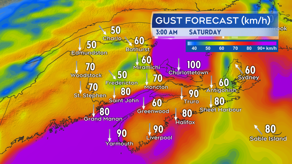
Strong northerly winds will create blowing snow and a risk of power outages Friday night into Saturday morning.
Very cold air will rush back into place region wide on Saturday. Be cautious of snowy and slushy surfaces turning to ice quickly.
There is also a risk of elevated coastal water levels at high tides during and directly following the passage of the storm. Environment Canada cautions to watch water levels during the high tide of Saturday afternoon for the eastern coastline of New Brunswick. For the northern coastline of P.E.I., watch water levels during the high tides late Saturday afternoon. The high tides Friday evening will be the one to watch for the Atlantic coastline of Nova Scotia and Saturday morning for the Northumberland and Gulf coasts. For more detailed tide times for your area you can check here.
The public is advised to monitor for further alerts issued for the storm. I’ll have updates and animated timelines daily on CTV Atlantic News Noon, 5 PM, 6 PM, and 11:30 PM.


CTVNews.ca Top Stories
BREAKING
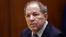
BREAKING Appeals court overturns Harvey Weinstein's 2020 rape conviction from landmark trial
New York’s highest court on Thursday overturned Harvey Weinstein’s 2020 rape conviction, finding the judge at the landmark #MeToo trial prejudiced the ex-movie mogul with improper rulings, including a decision to let women testify about allegations that weren’t part of the case.
BREAKING
BREAKING Honda to get up to $5B in govt help for EV battery, assembly plants
Honda is set to build an electric vehicle battery plant next to its Alliston, Ont., assembly plant, which it is retooling to produce fully electric vehicles, all part of a $15-billion project that is expected to include up to $5 billion in public money.
1 arrested in northern Alberta during public shelter order
Residents of John D'Or Prairie, a community on the Little Red River Cree Nation in northern Alberta, were told to take shelter Thursday morning during a police operation.
Secret $70M Lotto Max winners break their silence
During a special winner celebration near their hometown, Doug and Enid shared the story of how they discovered they were holding a Lotto Max ticket worth $70 million and how they kept this huge secret for so long.
Remains from a mother-daughter cold case were found nearly 24 years later, after a deathbed confession from the suspect
A West Virginia father is getting some sense of closure after authorities found the remains of his young daughter and her mother following a deathbed confession from the man believed to have fatally shot them nearly two decades ago.
Monthly earnings rise, payroll employment falls: jobs report
The number of vacant jobs in Canada increased in February, while monthly payroll employment decreased in food services, manufacturing, and retail trade, among other sectors.
First in Canada procedure performed at London, Ont. hospital
A London man has become the first person in Canada to receive a robotic assisted surgery on his spine. Dave Myeh suffered from debilitating, chronic back pain that led to sciatica in his right now and extreme pain in his lower back.
Doctors say capital gains tax changes will jeopardize their retirement. Is that true?
The Canadian Medical Association asserts the Liberals' proposed changes to capital gains taxation will put doctors' retirement savings in jeopardy, but some financial experts insist incorporated professionals are not as doomed as they say they are.
Something in the water? Canadian family latest to spot elusive 'Loch Ness Monster'
For centuries, people have wondered what, if anything, might be lurking beneath the surface of Loch Ness in Scotland. When Canadian couple Parry Malm and Shannon Wiseman visited the Scottish highlands earlier this month with their two children, they didn’t expect to become part of the mystery.
Shopping Trends
The Shopping Trends team is independent of the journalists at CTV News. We may earn a commission when you use our links to shop. Read about us.


Toronto
-
 BREAKING
BREAKING Honda to get up to $5B in govt help for EV battery, assembly plants
Honda is set to build an electric vehicle battery plant next to its Alliston, Ont., assembly plant, which it is retooling to produce fully electric vehicles, all part of a $15-billion project that is expected to include up to $5 billion in public money.
-
Man dead after reported push from downtown balcony: Toronto police
Toronto police say the homicide unit is investigating after a man was reportedly pushed to his death from a balcony downtown late Wednesday night.
-
Secret $70M Lotto Max winners break their silence
During a special winner celebration near their hometown, Doug and Enid shared the story of how they discovered they were holding a Lotto Max ticket worth $70 million and how they kept this huge secret for so long.
Calgary
-

Ex-Calgary mayor Nenshi expected to be focus of first Alberta NDP leadership debate
Former Calgary mayor Naheed Nenshi is expected to be the centre of attention as the first debate in the Alberta NDP leadership race is held Thursday night.
-
10 things to do in Calgary this weekend
Ten things happening around Calgary this weekend.
-
Doctors say capital gains tax changes will jeopardize their retirement. Is that true?
The Canadian Medical Association asserts the Liberals' proposed changes to capital gains taxation will put doctors' retirement savings in jeopardy, but some financial experts insist incorporated professionals are not as doomed as they say they are.
Edmonton
-

Alberta communities plead for more provincial firefighting help
Some Alberta municipalities say the province has been slow to react to calls for more firefighting support and a long-term plan to better protect communities outside the Forest Protection Area (FPA).
-
1 arrested in northern Alberta during public shelter order
Residents of John D'Or Prairie, a community on the Little Red River Cree Nation in northern Alberta, were told to take shelter Thursday morning during a police operation.
-
Edmonton Elks games to be broadcast in Punjabi by My Radio 580
Local multilingual radio station My Radio 580 will broadcast the Edmonton Elks' home games, the club announced Thursday.
Montreal
-

'There's really no justice': Quebec mother, daughter speak out after man gets house arrest for years of abuse
A mother and daughter are speaking out after a Quebec man was sentenced to house arrest for years of domestic abuse. They were both physically assaulted by the mother's ex-partner and say the offender got off with another light sentence.
-
Former Montreal baseball coach accused of sex assault on minor loses bid to throw out case
The trial of a West Island baseball coach accused of sexually abusing a minor will proceed after the case was almost thrown out due to unreasonable delays.
-
Ontario is increasing the speed limit to 110 km/h on some highways. Should Quebec?
Speaking to CTV News, some Montreal drivers said they were in favour of the new measure and said they'd like to see Quebec follow suit.
Ottawa
-

He got his stolen vehicle back, but even after repairs, it won't sell
It's another headache for drivers who have a vehicle stolen, what to do if they want to sell after their stolen vehicle was damaged and then recovered.
-
Petawawa Theatre prepares to reopen May 17
Many thought they had seen the final curtain call at Troyes Cinema, located on Garrison Petawawa, when the movie theatre closed in 2022.
-
State and Main launches campaign to support Dress for Success Ottawa
State and Main is getting ready to celebrate Mother’s Day through its third annual For Mom, For Women campaign this May.
London
-

One person suffered burns to their hands after trailer fire
Damage is estimated at $50,000 after a trailer parked in a St. Thomas driveway caught fire. Around 8:30 a.m. Thursday, first responders received multiple 911 calls reporting a large plume of smoke and flames from a camping trailer.
-
First in Canada procedure performed at London, Ont. hospital
A London man has become the first person in Canada to receive a robotic assisted surgery on his spine. Dave Myeh suffered from debilitating, chronic back pain that led to sciatica in his right now and extreme pain in his lower back.
-
Celebrating 100 years of service and fundraising for LHSC
The London Health Sciences Centre (LHSC) Auxiliary is celebrating 100 years of service. Since 1999, the Auxiliary has made contributions, totaling over $10 million towards the hospital's critical needs.
Barrie
-

Secret $70M Lotto Max winners break their silence
During a special winner celebration near their hometown, Doug and Enid shared the story of how they discovered they were holding a Lotto Max ticket worth $70 million and how they kept this huge secret for so long.
-
Major Honda Canada announcement expected today in Alliston
Reports indicate Honda is retooling its assembly plant in Alliston to produce fully electric vehicles.
-
U.K. instructors train Barrie police in victim support services
Instructors from the United Kingdom College of Policing brought the victim support instructors to Barrie.
Northern Ontario
-
Secret $70M Lotto Max winners break their silence
During a special winner celebration near their hometown, Doug and Enid shared the story of how they discovered they were holding a Lotto Max ticket worth $70 million and how they kept this huge secret for so long.
-
BREAKING
BREAKING Appeals court overturns Harvey Weinstein's 2020 rape conviction from landmark trial
New York’s highest court on Thursday overturned Harvey Weinstein’s 2020 rape conviction, finding the judge at the landmark #MeToo trial prejudiced the ex-movie mogul with improper rulings, including a decision to let women testify about allegations that weren’t part of the case.
-
BREAKING
BREAKING One person killed in Highway 101 crash near Kidd Creek Met site
A serious crash involving two vehicles has left one person dead and Highway 101 closed in the Timmins area since 1 a.m., police say.
Kitchener
-

Four people displaced by fire at Waterloo home
Three dogs died in the blaze.
-
Ont. teacher says she's being forced to switch pharmacies to maintain medication coverage
A Waterloo, Ont. teacher says she’s frustrated after learning the arthritis medication she depends on is no longer covered under her benefits plan and she'll have to switch pharmacies to avoid paying out of pocket.
-
Air ambulance needed for serious crash on King Street in Kitchener
A Waterloo man needed to be taken away by air ambulance following a crash on King Street.
Windsor
-

Rare snake habitat on Pelee Island to be restored
A snake habitat on Pelee Island will be restored. Through a multi-partner collaboration, conservation work on Pelee Island will continue through 2026.
-
Arrests made after 911 hang-up call in Chatham
A 911 hang-up call has led to the arrest of two people in Chatham-Kent. Just after 6:30 a.m. on Wednesday, officers responded to an address on Bloomfield Road for the hang-up call.
-
Convicted killer can ask for parole now: Windsor, Ont. jury accepts 'faint hope' application
A Windsor man convicted in a violent murder 20 years ago was successful in his ‘faint hope’ bid for an early chance at freedom after a jury agreed he should be given the chance to apply for early parole eligibility.
Winnipeg
-
 LIVE AT 11 AM
LIVE AT 11 AM Manitoba RCMP to make announcement on double homicide
The Manitoba RCMP is set to make an announcement on Thursday regarding a double homicide in the province.
-
Jury selection begins for Winnipeg trial of man accused of killing four women
Jury selection is set to start today for the trial of a Winnipeg man accused of killing four women.
-
'We are not here for tree preservation': Development company appealing latest decision with Lemay Forest
A new fight is gearing up at city hall over Lemay Forest.
Regina
-

'Not a village': Speed limit to remain 50 km/h in Regina's Cathedral area for now
The City of Regina has decided to not reduce speed limits in the Cathedral area for the time being.
-
'American style politics': Sask. Party's mass video text a risky way to grab support, experts say
Many Saskatchewan residents have been receiving unsolicited political text messages of the Sask. Party taking aim at the Saskatchewan NDP and their leader Carla Beck. Media experts say texting can be an effective campaign tool, but parties run the risk of annoying some voters.
-
Monthly earnings rise, payroll employment falls: jobs report
The number of vacant jobs in Canada increased in February, while monthly payroll employment decreased in food services, manufacturing, and retail trade, among other sectors.
Saskatoon
-
Sask. woman fights to find out who had her apprehended for a psych. assessment
A Saskatchewan woman who was taken for an involuntary mental health assessment is entitled to find out who had her committed, a provincial court judge has ruled.
-
'American style politics': Sask. Party's mass video text a risky way to grab support, experts say
Many Saskatchewan residents have been receiving unsolicited political text messages of the Sask. Party taking aim at the Saskatchewan NDP and their leader Carla Beck. Media experts say texting can be an effective campaign tool, but parties run the risk of annoying some voters.
-
Boeing invests $17 million in Sask. aviation program
International aircraft giant Boeing has made a multi-million dollar commitment to the Saskatchewan Indian Institute of Technology (SIIT) to help address shortages in the aviation industry.
Vancouver
-

RCMP confirms 2 bodies found in U.S. are missing B.C. kayakers
Mounties on Vancouver Island have confirmed that two bodies recovered by United States authorities earlier this week are those of a pair of missing kayakers from British Columbia.
-
'We got a head fake this week': Gas prices in B.C.'s Lower Mainland take unexpected leap
The yo-yoing gas prices in B.C.'s Lower mainland continues with fuel jumping nine cents Thursday morning.
-
Metro Vancouver mayors call for serial killer Robert Pickton to be denied parole
A dozen mayors from around Metro Vancouver say federal Attorney General and Justice Minister Arif Virani should deny parole for notorious B.C. serial killer Robert Pickton, and reassess the parole and sentencing system for 'prolific offenders and mass murderers.'
Vancouver Island
-
RCMP confirms 2 bodies found in U.S. are missing B.C. kayakers
Mounties on Vancouver Island have confirmed that two bodies recovered by United States authorities earlier this week are those of a pair of missing kayakers from British Columbia.
-
'It was instant karma': Viral video captures failed theft attempt in Nanaimo, B.C.
Mounties in Nanaimo, B.C., say two late-night revellers are lucky their allegedly drunken antics weren't reported to police after security cameras captured the men trying to steal a heavy sign from a downtown business.
-
Woman who killed Reena Virk calls new TV series disrespectful to victim
The B.C. woman convicted of killing Reena Virk described the TV series dramatizing the notorious 1997 murder as disrespectful to the victim and her family.
Kelowna
-

B.C. man rescues starving dachshund trapped in carrier: BC SPCA
An emaciated dachshund is now recovering thanks to a Good Samaritan who found the pup near a biking trail in Kelowna, according to the BC SPCA.
-
Search crews called in after missing Kelowna senior's truck found
Search and rescue crews have been called in after a vehicle belonging to a missing senior was located near a rural intersection outside of Kelowna Tuesday.
-
Homicide investigation underway after body found near Kelowna, B.C.
Major crime detectives in British Columbia are investigating a suspected homicide after a body was found in a remote area southeast Kelowna over the weekend.


