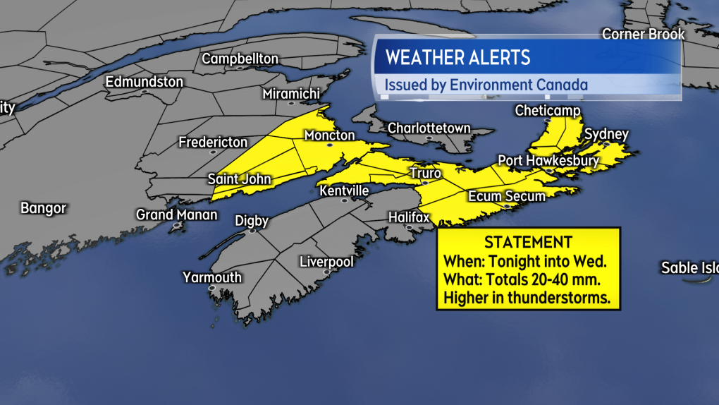
Maritime rainfall warnings and weather statements due to rain and thunderstorms
 A pedestrians walks through a rainstorm Thursday, July 13, 2023 in Montreal.THE CANADIAN PRESS/Ryan Remiorz
HALIFAX -
A series of Rainfall Warnings and Special Weather Statements have been issued for the Maritimes by Environment Canada.
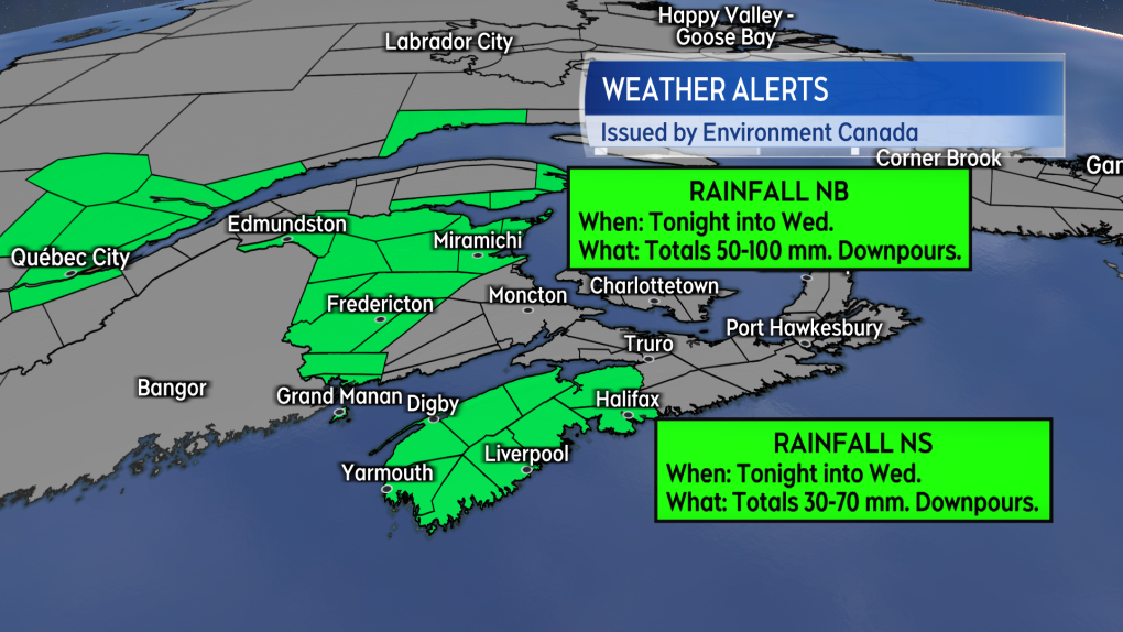
Rainfall warnings are in effect for most of New Brunswick. The warnings call for a period of heavy rain developing Tuesday into Wednesday morning. The warnings caution that intense downpours could cause flash flooding and localized flooding in low lying areas. The rain is forecast to ease to showers for Wednesday afternoon.
A Rainfall warning has also been issued for western mainland Nova Scotia. The warning calls for a rainfall of 30 to 70 millimetres with thunderstorms possibly bringing totals higher than 70 millimetres for some areas. Downpours are expected increasing the risk of flooding and flash flooding.
A Special Weather Statement extends across southeastern New Brunswick and eastern Nova Scotia, including Cape Breton. The statement calls for a general rain of 20 to 40 millimetres but with higher amounts possible in thunderstorms.
The risk of thunderstorms is highest Tuesday night into early Wednesday morning for southern New Brunswick and western mainland Nova Scotia. The risk of thunderstorms then shifts to eastern Nova Scotia, including Cape Breton, Wednesday morning through Wednesday afternoon.
 Special Weather Statements issued by Environment Canada.
Communities that have a thunderstorm move over should be aware that they could produce rain rates of 10 to 25 millimetres per hour and totals ranging 50 to 100 millimetres. Both the rate of rainfall and total amount of rain increases the risk of flooding and flash flooding.
The thunderstorms are expected to be scattered within the general area of rain, making it difficult to know if any individual communities will have a thunderstorm move directly over.
The risk of thunderstorms is generally higher tonight Wednesday morning in the southwestern corner of New Brunswick and for Halifax County down the South Shore in Nova Scotia.
A wind warning is also in effect for Inverness County – North of Mabou in Cape Breton. The warning calls for 90 kilometre per hour wind gusts from the southeast on Wednesday.
 Rainfall Warnings issued by Environment Canada.
The inclement weather is being brought on by a low pressure system centred over southern Quebec, but with weather fronts extending to the eastern seaboard of the U.S.
Heavy rain in northern New Brunswick and a risk of thunderstorms for the rest of the Maritimes extends into Wednesday morning.
By mid-afternoon Wednesday, the heavy rain clears northern New Brunswick. Scattered showers with a lower risk of thunderstorms persist for the Maritimes into Wednesday evening. The last of those showers clears Cape Breton in the early morning hours of Thursday.
Updates and regional weather conditions on CTV Atlantic News Five, Six, and Late.
Shopping Trends
The Shopping Trends team is independent of the journalists at CTV News. We may earn a commission when you use our links to shop. Read about us.


CTVNews.ca Top Stories

Calgary woman stranded in Mexico after husband's death during diving trip
A Calgary woman is struggling to return home after her husband died while diving in Mexico, leaving her stranded and facing financial hardship.
Fugitive U.S. rioter seeks asylum in Whistler amid warnings of more to come
An American citizen convicted of participating in the Jan. 6, 2021, riot on Capitol Hill and dodging jail time in Whistler may just be the start of an asylum-seeking rush, according to a prominent legal expert.
Soldier who died by suicide in Las Vegas told ex-girlfriend of pain and exhaustion after Afghanistan
The highly decorated Special Forces soldier who died by suicide in a Cybertruck explosion on New Year's Day confided to a former girlfriend who had served as an Army nurse that he faced significant pain and exhaustion that she says were key symptoms of traumatic brain injury.
Special national Liberal caucus meeting called for next week after regional chairs meet: sources
A special meeting of Prime Minister Justin Trudeau's national Liberal caucus has been called for next Wednesday, sources say.
N.S. community shocked by deaths of father, daughter; suspect was wanted in Toronto shooting
A Nova Scotia community is mourning the loss of two of its members after they were shot and killed in Halifax on New Year's Eve.
'Inadmissible' foreign nationals to pay more upon return to Canada: CBSA
Foreign nationals who refuse or are unable to pay their own way home after being denied stay in Canada will soon face steeper financial penalties should they ever attempt to return.
Canada pausing applications for parent, grandparent permanent residency sponsorships
Canada will not accept new parent and grandparent permanent residency sponsorship applications until further notice, according to a ministerial directive.
opinion
opinion From feel-good family films to a zombie horde sequel: The most anticipated movies of 2025
Whether you go to the movies to laugh, cry or escape reality, 2025 looks primed to offer up something for everyone. CTV film critic Richard Crouse has put together a list of some of the most anticipated films.
Trump's sentencing is set for Jan. 10. Here's what could happen next
Faced with the never-before-seen dilemma of how, when or even whether to sentence a former and future U.S. president, the judge in President-elect Donald Trump 's hush money case made a dramatic decision that could nevertheless bring the case to a muted end.
Toronto
-

2 Royal Military College students jumped into action to save a man from a burning car in North York
A black Ford Mustang had lost control while traveling north along Bayview, crashing into cement pillars near the stores loading dock.
-
Union representing Ontario college faculty issues five-day strike notice
Ontario college students could soon see their winter semester cut short as the union representing faculty at the province’s 24 public colleges could walk off the job as early as Thursday next week.
-
Ontario aiming to send out $200 rebate cheques later this month or early February
Ontarians should receive their $200 rebate cheque from the province by the end of January or early February, a government spokesperson confirmed in an email Friday.
Calgary
-

Community grieves as one at vigil for Calgary double homicide victims
They braved the cold to pay tribute to a Calgary mother of three and her father, killed just days after Christmas.
-
Calgary woman stranded in Mexico after husband's death during diving trip
A Calgary woman is struggling to return home after her husband died while diving in Mexico, leaving her stranded and facing financial hardship.
-
Third person charged with first-degree murder in Lethbridge motel death
A third person has been charged with first-degree murder after a woman was found dead in a Lethbridge motel room over the weekend.
Edmonton
-

'Flames were shooting higher than the garage': Block heater cords cause 2 fires in 2 days in Edmonton
Peter Claffey was shocked Thursday morning to find his truck in flames outside his southwest Edmonton home.
-
Homicide investigation underway after woman found dead on Edmonton riverbank
Police have identified a woman who was recently found dead on the shore of the North Saskatchewan River in Edmonton.
-
Gas leak slows traffic on 111 Avenue Friday night
Drivers were asked to avoid 111 Avenue near 110 Street due to a gas leak on Friday night.
Montreal
-

Lachine tenants have been out of heat and hot water for 2 months
A 47-unit building hasn't had hot water for nearly two months, and the heat is out too, forcing the city to intervene.
-
More homeless people hiding from the cold in Montreal's crowded ERs
When warming centres are full, homeless people with nowhere to go are turning to emergency rooms.
-
Montreal police make 2 more arrests in killing of Claudia Iacono
Montreal police have arrested two more suspects in the slaying of Claudia Iacono.
Ottawa
-
Flurries, cold temperatures in the forecast for Ottawa this Saturday
It feels like -20 with the wind chill this Saturday morning in Ottawa.
-
Great ice-making weather on the way for Ottawa as winter returns to form
After two winters with above-average temperatures and poor-quality ice on skating surfaces around the capital, the city can expect a more traditional Ottawa winter.
-
Highrise fire on Ramsey Crescent displaces 39 residents, injures 16
The Ottawa Paramedic Service says four adult women were taken to hospital following a fire that happened in a highrise on Ramsey Crescent, in the west end of Ottawa, in the early hours of Friday morning.
London
-

The Forest City will get walloped by snow this weekend
If you’ve tucked your shovel away since the last snowfall, it’s time to haul It back out. Snowfall accumulation could exceed 20 centimeters in London by Sunday morning.
-
Heritage protection might save this 200-year-old oak tree in London
Recognition that certain trees contribute to the heritage of the Blackfriars-Petersville neighbourhood might save the life of a centuries-old oak.
-
London Knights blow out Niagara on home ice
The London Knights ran up the score against the Niagara IceDogs Friday night at Canada Life Place, earning a 9-4 win.
Barrie
-

Georgian College faculty 'energized' after union issues strike notice
Faculty at Georgian College are energized as their union has put a possible strike on the table with students set to head back to class next week.
-
Persistent snow squalls bring heavy accumulations to Barrie area
Environment Canada is maintaining its snow squall warning for most of central Ontario on Friday.
-
Warrant issued for allegedly armed and dangerous man wanted for attempted murder
Police in York Region have issued an arrest warrant for one man following a reported shooting at a motel in Queensville.
Northern Ontario
-

Suspect charged in northern Ont. road rage incident that went viral
A 37-year-old suspect has been charged in connection with a road rage incident last week in Temiskaming Shores.
-
Northern staff react to Ontario college faculties issuing five-day notice of labour action
College faculty in Ontario gave its five-day notice of starting labour action on Friday, which could include a strike or some other work stoppage at the 24 schools within the province.
-
Sault, Ont., man claims Indigenous moose hunting rights without proof, fined $5,500
A hunter from Sault Ste. Marie, Ont., has been fined for moose hunting without a licence or proper documentation. He claimed Indigenous hunting rights but failed to provide any proof.
Kitchener
-

Snow squall warnings for southwestern Ontario
Environment Canada says southwestern Ontario could get between 15 and 60 centimetres of snow by Saturday.
-
Union representing Ontario college faculty issues five-day strike notice
Ontario college students could soon see their winter semester cut short as the union representing faculty at the province’s 24 public colleges could walk off the job as early as Thursday next week.
-
Volunteers get ice rinks ready for skating season
Now that there’s a stretch of sub-zero temperatures in the forecast, volunteers have been busy getting ice rinks ready for skaters.
Windsor
-

2.99% tax increase in proposed 2025 Windsor budget
The proposed 2025 City of Windsor budget includes a 2.99 per cent tax increase.
-
-
'It was a privilege to work alongside him': Habitat for Humanity Windsor-Essex joins worldwide memorial for Jimmy Carter
Habitat for Humanity Windsor-Essex is joining a worldwide memorial for late U.S. President Jimmy Carter.
Winnipeg
-

'Hopeful that we can make this go': Potential $5.25 million bid made for Lemay Forest
There is a new offer to buy and preserve the Lemay Forest.
-
'An enormous data set': Christmas Bird Count looks at avian health in Winnipeg, North America
When you look out your window this weekend, chances are you will see birds but have you ever wondered how many feathered friends are flying around? The Christmas Bird Count seeks those answers every year.
-
New train detection system on track to alert motorists, first responders about railway traffic
Winnipeg may soon see a new train detection system that lets motorists know when to use alternate routes and avoid railway crossings.
Regina
-

Sask. RCMP investigating woman's death on Piapot First Nation
Saskatchewan RCMP says it is investigating the death of a 30-year-old woman on Piapot First Nation as suspicious in nature.
-
SaskAbilites Yorkton enhances relaxation room
SaskAbilities Yorkton has enhanced their relaxation room to help people with disabilities experience a more comfortable and calming environment.
-
CTV Regina's top trending stories of 2024
Whether it was hard news or light-hearted features, the year of 2024 hosted some very compelling stories – with several being widely shared online and reaching new audiences.
Saskatoon
-

$20k of equipment stolen from rural Sask. Fire hall. And it's not the only one
Rural firehalls surrounding Saskatoon are having to deal with escalating thefts that could put rescue efforts in jeopardy.
-
Two people charged with murder after suspicious death on Sask. First Nation
A man and a woman have been charged with first degree murder after a 24-year-old man died of injuries on Saulteaux First Nation.
-
Inmate who escaped federal prison in Saskatchewan arrested
After about five months of searching, police have arrested Jareth Gardipy-Taypotat, who escaped from the Willow Cree Healing Lodge, a minimum-security federal institution north of Saskatoon.
Vancouver
-

Fugitive U.S. rioter seeks asylum in Whistler amid warnings of more to come
An American citizen convicted of participating in the Jan. 6, 2021, riot on Capitol Hill and dodging jail time in Whistler may just be the start of an asylum-seeking rush, according to a prominent legal expert.
-
Former Four Seasons Hotel in downtown Vancouver to be demolished
A former luxury hotel tower in downtown Vancouver is slated to be demolished.
-
Accused in armed robbery at Vancouver Holt Renfrew has prior convictions
The 66-year-old man accused of holding up a Holt Renfrew in downtown Vancouver this week has prior convictions, including for two other robberies that involved fake guns.
Vancouver Island
-

B.C. driver who tried to apprehend suspected impaired driver was impaired: RCMP
Mounties on Vancouver Island say a 50-year-old motorist who tried to apprehend a suspected impaired driver on New Year's Eve, was, in fact, impaired and was issued a 90-day driving prohibition by police.
-
Attending hundreds of serious crash scenes each year takes its toll, B.C. first responders say
Just days into the new year, officials are already pleading with British Columbians to follow the rules of the road.
-
Woman, 63, dead after collision on Vancouver Island
A 63-year-old woman is dead after the car she was driving collided with a truck on southern Vancouver Island.
Kelowna
-

Charges laid after child porn investigation that 'spanned several different countries,' Kelowna RCMP say
Police in Kelowna say an international investigation has led to child pornography charges against a 46-year-old man.
-
Mounties investigate discovery of 'very small pipe bomb' in Kamloops, B.C.
Mounties are investigating and appealing for witnesses after an explosive device was discovered Wednesday on a beach in Kamloops, B.C.
-
Kamloops couple delivers B.C.'s first baby of 2025
B.C.'s first baby of 2025 was born just after midnight at Royal Inland Hospital in Kamloops.


