Hurricane watches issued ahead of weekend arrival of Fiona
A series of hurricane and tropical storm watches were issued for Atlantic Canada by Environment Canada and the Canadian Hurricane Centre Thursday afternoon. A watch means that hurricane or tropical storm conditions are possible in the alerted area within 36 hours.
TRACK
Hurricane Fiona continues to pick up speed towards the north as a Category 4 hurricane, now moving at nearly 25 kilometres per hour. The storm is forecast to pass to the west of Bermuda and enter the Scotian Slope marine waters of Atlantic Canada as a Category 3 hurricane on Friday.
Landfall as a powerful post-tropical storm, equivalent to a Category 1 or 2 hurricane looks increasingly likely in eastern Nova Scotia Saturday morning. The forecast cone for that landfall has now narrowed to span eastern Halifax County across Cape Breton. Various computer models show a landfall somewhere in the area from Canso to near Louisbourg in Nova Scotia between 6 a.m. and 10 a.m. Saturday. Weather conditions in the Maritimes will deteriorate Friday night into Saturday morning.
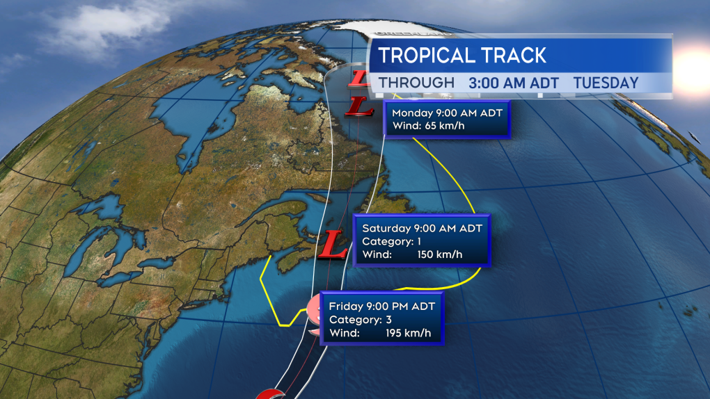 Fiona is expected to enter Canadian waters as a Category 3 hurricane late Friday. Becoming a power post-tropical storm as it makes landfall in eastern Nova Scotia Saturday morning.
HURRICANE WATCH ISSUED
A hurricane watch has been posted for Prince Edward Island and Halifax -- east across Nova Scotia. Tropical storm watches extend into the southwest of Nova Scotia and eastern New Brunswick.
The highest probabilities of hurricane force winds -- a one-minute sustained wind of 119 kilometres per hour or more -- are near and to the east of the expected landfall point. At this time, that includes parts of Guysborough and Antigonish counties on the mainland of Nova Scotia, as well as Cape Breton. Tropical storm force winds -- a one-minute sustained wind of 63 kilometres per hour -- are being given a high probability across P.E.I. and Halifax – in eastern Nova Scotia.
A moderate probability of a tropical storm force wind extends into the south shore of Nova Scotia and southeastern New Brunswick. Gust strength will exceed those one-minute sustained winds.
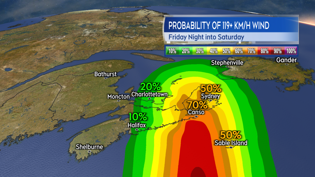 The highest probability of a hurricane force wind will be near and to the east of the landfall point. Currently looking most likely to be in eastern Nova Scotia.
 The risk of tropical storm force winds extends across much of Nova Scotia, Prince Edward Island, and into southeastern New Brunswick. That is a one minute sustained wind near 63 km/h with gusts possibly reach 100 km/h or higher.
WIND
Wind will increase in strength for much of the Maritimes Friday night into Saturday morning.
Peak gusts in eastern Nova Scotia and P.E.I. could reach 120 to 150 kilometres per hour due to being in proximity to the centre of the storm as it passes. That said, widespread gusts reaching 90 to 120 kilomtres per hours look possible, extending as far west as Halifax in Nova Scotia.
Gusts reaching 70 to 90 kilometres per hour could possibly extend into the southwest of Nova Scotia and eastern New Brunswick. Wind direction will primarily be out of the north and northwest. The exception is the area east of the landfall point, most likely Cape Breton, where the direction will be easterly turning southerly.
Wind of that strength will have the potential to cause power outages. In the eastern part of the region, where the wind is forecast to be strongest, there is an increased risk of tree and branch falls. Where the wind is onshore, it will help to produce a ferocious surf and risk of storm surge.
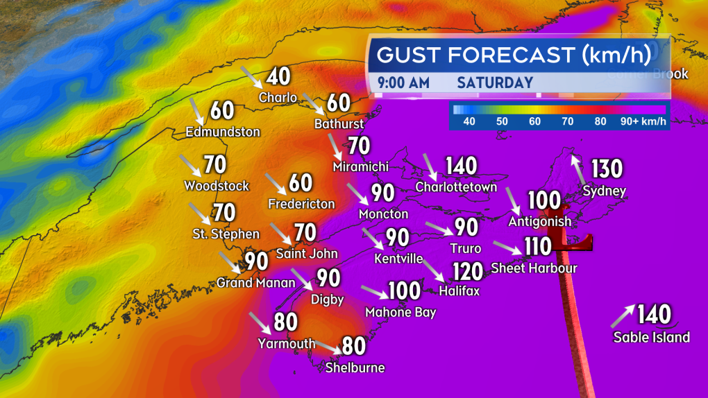 The strongest wind gusts look increasingly likely for eastern Nova Scotia and Prince Edward Island.
STORM SURGE
The greatest risk of a damaging storm surge looks to be the eastern and northern coastlines of Nova Scotia, the southeastern coastline of New Brunswick, and the northern coastline of P.E.I. The very low barometric pressure in the centre of the storm will allow for ocean water to rise up under it.
Intense winds will increase wave action against the coast further increasing the risk of flooding or damage. Near coastal waves reaching 10 metres, or 30 feet, may be present on the eastern shore of Nova Scotia late Friday night into Saturday morning.
A significant build of wave height in the Gulf of St. Lawrence is also expected, increasing the risk of erosion on north facing beaches of P.E.I. There is a period of high tide for the eastern part of the Maritimes Saturday morning -- particular caution should be taken during that tide. Waves and risk of storm surge should diminish moving through Saturday afternoon into Saturday evening.
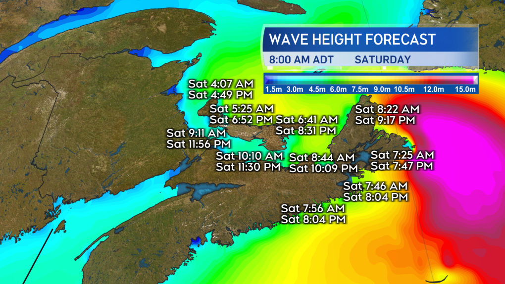 The risk of a damaging storm surge is highest in the east of the Maritimes. Extra caution should be taken if by the coast in that area particularly during the high tide Saturday morning.
RAINFALL
Torrential rain is expected for eastern parts of the Maritimes Friday night into Saturday morning. Friday through Saturday could see rain totals of 80 to 200 millimetres in eastern P.E.I. and eastern Nova Scotia increasing the risk of flash flooding and washouts. Rainfall totals could reach 50 to 80 millimetres extending towards the west of P.E.I. and central areas of Nova Scotia. There is potential for heavy rainfalls to quickly move into New Brunswick and the southwest of Nova Scotia.
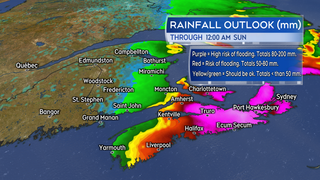 The risk of flooding is expected to be highest in eastern Prince Edward Island and eastern Nova Scotia. Rain in that part of the Maritimes could total 80 to 200 mm Friday through Saturday.
PREPARATIONS
Maritimers who have them should make sure that sump pumps and generators are in working order and the drainage on their property is clear of debris.
Other storm preparations to take include:
- having batteries for use in flashlights and lamps
- making sure mobile devices are charged
- stocking up on food and medication to last a period of 72 hours
- not travelling during the passage of the storm and the worst of the inclement weather


CTVNews.ca Top Stories

Parents of infant who died in wrong-way crash on Ontario's Hwy. 401 were in same vehicle
Ontario’s Special Investigations Unit has released new details about a wrong-way collision in Whitby on Monday night that claimed the lives of four people.
Three Quebec men from same family father hundreds of children
Three men in Quebec from the same family have fathered more than 600 children.
B.C. mayor stripped of budget, barred from committees over Indigenous residential schools book
A British Columbia mayor has been censured by city council – stripping him of his travel and lobbying budgets and removing him from city committees – for allegedly distributing a book that questions the history of Indigenous residential schools in Canada.
OPP's mandatory alcohol screening during traffic stops 'not acceptable': CCLA
A spike in impaired driving-related collisions has caused Ontario’s provincial police to begin enforcing mandatory alcohol screening (MAS) at all traffic stops in the Greater Toronto Area -- a move one civil rights group says is ‘not acceptable.’
Maple Leafs down Bruins 2-1 to force Game 7
William Nylander scored twice and Joseph Woll made 22 saves as the Toronto Maple Leafs downed the Boston Bruins 2-1 on Thursday to force Game 7 in their first-round series.
Jurors in Trump hush money trial hear recording of pivotal call on plan to buy affair story
Jurors in the hush money trial of Donald Trump heard a recording Thursday of him discussing with his then-lawyer and personal fixer a plan to purchase the silence of a Playboy model who has said she had an affair with the former president.
Southern Alberta store broken into by burly black bear
Staff at a small southern Alberta office supply store were shocked to find someone had broken into the business last week, but they were even more confused when they discovered the culprit was a bear.
Captain sentenced to 4 years for criminal negligence in fiery deaths of 34 aboard scuba boat
A federal judge on Thursday sentenced a scuba dive boat captain to four years in custody and three years supervised release for criminal negligence after 34 people died in a fire aboard the vessel.
New scam targets Canada Carbon Rebate recipients
Fake text message and email campaigns trying to get money and information out of unsuspecting Canadian taxpayers have started circulating, just months after the federal government rebranded the carbon tax rebate the Canada Carbon Rebate.
Shopping Trends
The Shopping Trends team is independent of the journalists at CTV News. We may earn a commission when you use our links to shop. Read about us.


Toronto
-

Maple Leafs down Bruins 2-1 to force Game 7
William Nylander scored twice and Joseph Woll made 22 saves as the Toronto Maple Leafs downed the Boston Bruins 2-1 on Thursday to force Game 7 in their first-round series.
-
Parents of infant who died in wrong-way crash on Ontario's Hwy. 401 were in same vehicle
Ontario’s Special Investigations Unit has released new details about a wrong-way collision in Whitby on Monday night that claimed the lives of four people.
-
Progressive Conservatives win both Ontario byelections
Premier Doug Ford's Progressive Conservative candidates have won both Ontario byelections by convincing margins.
Calgary
-

Suspect sought following arson at northeast Calgary church
Police are looking for a man who set a nativity scene on fire at a church in northeast Calgary.
-
Ottawa announces emissions progress as Capital Power cancels $2.4B carbon capture project
Ottawa released its Greenhouse Gas Emissions Report on Thursday, less than a day after a major carbon capture and storage project was scrapped by Edmonton-based Capital Power.
-
Fuel tanker and pickup collide on Highway 2 near Okotoks, injuring 2
The southbound lanes of Highway 2 are closed near Okotoks after RCMP say a fuel tanker and pickup truck collided.
Edmonton
-

Ottawa announces emissions progress as Capital Power cancels $2.4B carbon capture project
Ottawa released its Greenhouse Gas Emissions Report on Thursday, less than a day after a major carbon capture and storage project was scrapped by Edmonton-based Capital Power.
-
'Nothing into something': Little potatoes turn into big success for Edmonton company
A produce company with Edmonton roots has found big success with tiny potatoes.
-
'I'm coming here every day': Edmonton shoppers lukewarm on Loblaw boycott
A campaign that started online has many Canadian shoppers promising to boycott Loblaw companies in May, but a local expert says the boycott is unlikely to take off.
Montreal
-

Counter-protesters face off with pro-Palestinian encampment group at McGill University
A heavy police presence was at McGill University on Thursday morning, as counter-protesters assembled opposite the pro-Palestinian encampment at the school.
-
Planets aligned for Quebec astrologer's lottery win
A Montreal astrologer and horoscope writer just got a boost on his retirement budget, after winning Loto-Quebec’s Grande-Vie prize, which comes in the form of $1,000 a day for life.
-
Quebec premier asks police to dismantle camp at McGill University
Quebec Premier Francois Legault has called on the police to dismantle the pro-Palestinian protest encampment on the lower field of McGill University's downtown campus in Montreal.
Ottawa
-
 NEW THIS MORNING
NEW THIS MORNING What's happening in Ottawa this weekend: May 3-5
CTVNewsOttawa.ca looks at things to do in Ottawa during the first weekend of May.
-
Forcing public servants back to downtown Ottawa harms satellite communities: North Grenville mayor
The mayor of North Grenville, just south of Ottawa, says hybrid work has been a boon to her community, and a recent move by the federal government to force public servants back to downtown Ottawa office buildings is misguided.
-
Former Ottawa city councillor Diane Deans in palliative care
Former Ottawa city councillor Diane Deans is in palliative care after a five-year battle with ovarian cancer, according to Gloucester-Southgate Coun. Jessica Bradley.
London
-

Clean up outside derelict building doesn’t quell concerns about trespassing and fire risk
Despite a recent clean-up around the former St. Pierre Renovation Centre, concern persists about trespassing and the risk of fire at the former industrial building.
-
Progressive Conservatives hold seat in Lambton-Kent-Middlesex byelection
The Progressive Conservatives have won their seat in the Lambton-Kent-Middlesex provincial riding.
-
Three people in hospital following crash east of London, Ont.
A two-vehicle crash involving a transport truck and a passenger vehicle closed Dundas Street, just west of Thamesford, late Thursday afternoon.
Barrie
-

Barrie's photo radar cameras are moving to new locations: Here's where
Barrie's photo radar cameras will relocate to new community safety zones this month to curb speeding on neighbourhood roads.
-
Man charged with attempted murder after assault allegations
Police in Barrie charged one man with attempted murder after an alleged assault sent one individual to a trauma centre with life-threatening injuries on Tuesday.
-
Family of man killed in Wasaga Beach crash breaks silence ahead of trial
The family of Jim Lynne is speaking out for the first time since his death in a crash in Wasaga Beach two years ago as the man accused of drunk driving that night prepares to head to trial.
Northern Ontario
-

Triple murder or manslaughter? Sudbury jury deliberating fate of man responsible for fatal firebombing
After a lengthy series of instructions from Justice Dan Cornell, a Sudbury jury is deliberating whether to find a suspect guilty of three counts of manslaughter or three counts of murder.
-
Northern Ont. police forced into the river to save intoxicated swimmer
An intoxicated man wearing only his underwear and a lifejacket had to be pulled from the Thessalon River early Wednesday evening.
-
This Canadian restaurant just lowered its prices. Here's how it did it
A Canadian restaurant lowered its prices this week, and though news of price tags dropping rather than climbing sounds unusual, the business strategy in this case is not, according to experts in the field.
Kitchener
-

Magic mushroom shops in Kitchener and Cambridge raided – again
Police have once again raided magic mushroom dispensaries in Kitchener and Cambridge.
-
New Hamburg, Ont. family can't get truck's faulty transmission fixed due to aftermarket attachment
A New Hamburg family is feeling deflated after buying a new Toyota hybrid truck.
-
Sexually transmitted infection rates rising in Wellington-Dufferin-Guelph
Doctors in Guelph and Wellington County are seeing more sexually transmitted infections post-pandemic.
Windsor
-

Trucker convicted of importing $29M in meth across Ambassador Bridge
A truck driver has been convicted of importing $29 million in methamphetamine across the Ambassador Bridge in Windsor.
-
Sinkhole fixed on University Avenue
The intersection of University Avenue at Church Street has reopened after crews repaired a large sinkhole.
-
'It’s unfortunate': Vandals cut wires to window washer aerial lift truck
Men in Kilts owner Ben Snow is frustrated after discovering an aerial lift truck his window washing team had been using at a two-day job near downtown Windsor had been vandalized sometime overnight earlier this week.
Winnipeg
-

'System failures': Starbucks to close its doors amid recent violence in Osborne Village
The long-standing Starbucks in Osborne Village is set to close its doors next week – it comes one day after a man was attacked next door.
-
Manitoba looking to crack down on sex trafficking in hotels
Manitobans are being invited to weigh in on a hospitality regulation designed to prevent sexual exploitation in the industry.
-
Jets enter off-season in disbelief, wanting more after early playoff exit
Disbelief seemed to be the overriding emotion among the Winnipeg Jets after their early exit from the NHL playoffs.
Regina
-

Indian Head RCMP respond to 'serious' collision on Highway 1
A serious collision at the intersection of Highway #1 and Highway #606 near Sintaluta, Sask. has reduced traffic to one lane.
-
Sask. harm reduction workers feeling the effects of 'recovery-based' strategy
Three months since the Government of Saskatchewan stopped funding single use pipes and needles for safe consumption sites – those working on the ground with people battling addiction say the effects are clear.
-
'Progressing the right way': Regina Airport back to pre-pandemic traveller numbers, annual report says
Passenger volumes have returned to near pre-pandemic levels at Regina’s International Airport (YQR).
Saskatoon
-

'Absolutely necessary': Snow, rain easing concerns for Sask wildfire season, farmers
If April showers bring May flowers, then what does snow in May bring?
-
An 18-year-old was stabbed on a Saskatoon bus, police say
Saskatoon police are investigating an assault on a city bus after an 18-year-old man was stabbed on Wednesday afternoon.
-
'Healthy, happy calves': Cow gives birth to rare set of quadruplets in Saskatchewan
A Saskatchewan family won the bovine lottery after their cow gave birth to a rare set of quadruplets.
Vancouver
-

'SIM swap' that enabled theft of $63K in bitcoin at centre of B.C. court case
A Freedom Mobile customer who sued the company for negligence after a "SIM swap" scam cost him more than $63,000 in bitcoin will have to go through the company's arbitration process to pursue his claim, a B.C. court has ruled.
-
Surrey crash leaves pedestrian with 'significant injuries': RCMP
A pedestrian was seriously injured when they were struck by a vehicle in Surrey Thursday, according to authorities.
-
Vancouver to consider loosening moratorium on gambling expansions
A long-standing freeze on the number of gambling tables and machines allowed in Vancouver could be relaxed on behalf of the Parq Casino and Hastings Racecourse.
Vancouver Island
-

B.C. First Nation urges boaters to stay away from recently freed orca calf
The Ehattesaht First Nation is urging boaters to steer clear of a young orca calf that recently escaped a B.C. lagoon where she had been stranded for weeks after her pregnant mother died.
-
B.C. man convicted of fentanyl trafficking after judge rejects claim drugs belonged to a friend
A B.C. man has been convicted of possessing fentanyl for the purpose of trafficking despite claiming the drugs were not his – a defence the judge said he could not "accept or even entertain."
-
Metro Vancouver police seize several kilos of drugs in raids connected to B.C. gang conflict
Mounties are recommending charges against several people after officers seized more than 10 kilograms of suspected fentanyl, cocaine, methamphetamine and opioid pills during a series of raids in Metro Vancouver.
Kelowna
-

B.C. breweries take home awards at World Beer Cup
Out of more than 9,000 entries from over 2,000 breweries in 50 countries, a handful of B.C. brews landed on the podium at the World Beer Cup this week.
-
B.C. man rescues starving dachshund trapped in carrier: BC SPCA
An emaciated dachshund is now recovering thanks to a Good Samaritan who found the pup near a biking trail in Kelowna, according to the BC SPCA.
-
Search crews called in after missing Kelowna senior's truck found
Search and rescue crews have been called in after a vehicle belonging to a missing senior was located near a rural intersection outside of Kelowna Tuesday.


