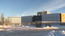
More spring snow to hit the Maritimes Sunday
While one round of snow and rain has passed, another is lined up for the end of the weekend.
The system that rolled through Thursday night into Friday brought the most snow to parts of northern and eastern New Brunswick, Prince Edward Island, and Cape Breton.
Those areas of New Brunswick and Prince Edward Island saw a widespread 10 to 20 cm. Meanwhile, Victoria County and the Sydney Metro-Cape Breton County areas saw snow totals in the 20 to 35 cm range.
More snow is possible for Cape Breton Friday night into early Saturday morning as a northwesterly wind brings in flurries off the Gulf of St. Lawrence.
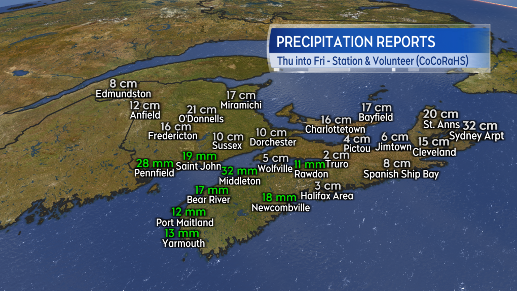 Preliminary and unofficial snow and rain reports for the Thursday/Friday system.
With a ridge of high-pressure building in from the west, Saturday will see the fairest weather of the weekend. There will be a general mix of sun and cloud and a low chance of flurries in Nova Scotia around the North Shore and Cape Breton.
High temperatures will generally be in the low-to-mid single digits for the Maritimes with communities on the South Shore of Nova Scotia possibly reaching 7 C to 10 C. Wind will be breezy and variable in direction for New Brunswick.
Wind will be blustery and from the north for both Nova Scotia and Prince Edward Island. That brings us to Sunday and our next round of active weather.
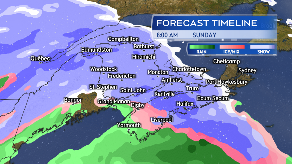 Snow returns Sunday morning to the Maritimes. The snow mixing over to ice pellets and rain in southwestern New Brunswick and western Nova Scotia.
As Saturday’s high-pressure shifts to the east, space will open for a low-pressure system to move in from the northeastern United States on Sunday.
Snow will likely start in western New Brunswick and western Nova Scotia before sunrise Sunday. The snow will reach eastern New Brunswick, Prince Edward Island, and eastern Nova Scotia before noon.
A turn from snow to a mix of ice pellets and rain is expected around coastal southwestern New Brunswick and western Nova Scotia. Snow, ice pellets and rain will become lighter Sunday evening. Lighter snow and flurries are likely to linger in some areas into Monday morning.
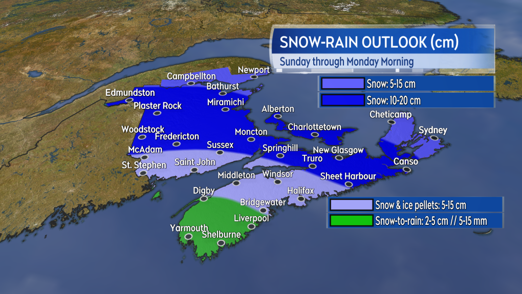 A large area of the Maritimes could pick up another 10 to 20 cm of snow. Snow amounts lower where more ice pellets and rain are present.
Given the mix of precipitation, it's hard to tell what amounts will look like – particularly at a time of year when the sun is getting stronger.
Once again, it looks like northern and eastern areas of the Maritimes will have the highest chance of picking up 10 to 20 cm of snow. Snow may taper lower in Cape Breton if the island ends up on the northern part of the storm.
Southwestern New Brunswick and central Nova Scotia will see varied amounts of five to 15 cm in a mix of snow, ice pellets, and rain. Accumulation there will be heavily dependent on the nature of that mix. A turn to rain does look likely in southwestern Nova Scotia, which may limit snow amounts there to five cm or less.
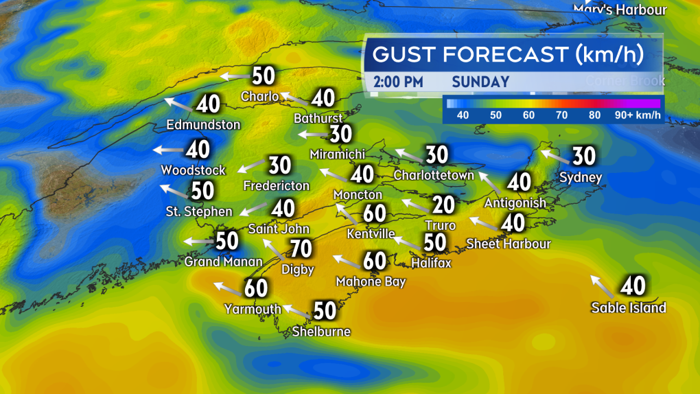 Gusty easterly winds will accompany the mix of snow, ice pellets, and rain Sunday.
A gusty, easterly wind will accompany the mix of precipitation. That wind will pick up Sunday morning into the afternoon. Gusts look to peak in the range of 40 to 70 km/h with the strongest on exposed areas of the coast and at higher terrain. The wind turns northerly and diminishes Sunday night into Monday morning.
Shopping Trends
The Shopping Trends team is independent of the journalists at CTV News. We may earn a commission when you use our links to shop. Read about us.


CTVNews.ca Top Stories

Back on air: John Vennavally-Rao on reclaiming his career while living with cancer
'In February, there was a time when I thought my career as a TV reporter was over,' CTV News reporter and anchor John Vennavally-Rao writes.
The winter solstice is here, the Northern Hemisphere's darkest day
The winter solstice is Saturday, bringing the shortest day and longest night of the year to the Northern Hemisphere — ideal conditions for holiday lights and warm blankets.
Poilievre writes to GG calling for House recall, confidence vote after Singh declares he's ready to bring Liberals down
Conservative Leader Pierre Poilievre has written to Gov. Gen. Mary Simon, imploring her to 'use your authority to inform the prime minister that he must' recall the House of Commons so a non-confidence vote can be held. This move comes in light of NDP Leader Jagmeet Singh publishing a letter stating his caucus 'will vote to bring this government down' sometime in 2025.
School custodian stages surprise for Kitchener, Ont. students ahead of holiday break
He’s no Elf on the Shelf, but maybe closer to Ward of the Board.
Kelly Clarkson's subtle yet satisfying message to anyone single this Christmas
The singer and daytime-talk show host released a fireside video to accompany her 2021 holiday album, “When Christmas Comes Around” that she dubbed, “When Christmas Comes Around…Again.
Judge sentences Quebecer convicted of triple murder who shows 'no remorse'
A Quebecer convicted in a triple murder on Montreal's South Shore has been sentenced to life in prison without chance of parole for 20 years in the second-degree death of Synthia Bussieres.
At least 2 dead, 60 hurt after car drives into German Christmas market in suspected attack
A car plowed into a busy outdoor Christmas market in the eastern German city of Magdeburg on Friday, killing at least two people and injuring at least 60 others in what authorities suspect was an attack.
16-year-old German exchange student dies after North Vancouver crash
A 16-year-old high school student from Germany who was hit by a Jeep in North Vancouver, B.C., last weekend has died in hospital, authorities confirmed.
Poilievre to Trump: 'Canada will never be the 51st state'
Conservative leader Pierre Poilievre is responding to U.S. president-elect Donald Trump’s ongoing suggestions that Canada become the 51st state, saying it will 'never happen.'
Toronto
-

'It's about protecting Canadian content': Leading Canadian publishing house seeks solutions to expected rise in distribution costs
One of Canada’s leading publishing houses is worried that it may soon not be able to keep up with the rising costs of storing the hundreds of book titles it distributes, potentially impacting the availability of educational materials and trade books from coast to coast.
-
Back on air: John Vennavally-Rao on reclaiming his career while living with cancer
'In February, there was a time when I thought my career as a TV reporter was over,' CTV News reporter and anchor John Vennavally-Rao writes.
-
The winter solstice is here, the Northern Hemisphere's darkest day
The winter solstice is Saturday, bringing the shortest day and longest night of the year to the Northern Hemisphere — ideal conditions for holiday lights and warm blankets.
Calgary
-

Calgary non-profit Yes Youth Centre hands out hundreds of free turkeys in Forest Lawn
Turkeys were flying out the door at the “Yes Youth Centre” in Forest Lawn Friday morning.
-
Wild boar hybrid identified near Fort Macleod, Alta.
Acting on information, an investigation by the Municipal District of Willow Creek's Agricultural Services Board (ASB) found a small population of wild boar hybrids being farmed near Fort Macleod.
-
3 people sent to hospital after serious crash on Deerfoot Trail
A serious crash on Deerfoot Trail sent three people to hospital, including one in potentially life-threatening condition, on Friday afternoon.
Edmonton
-
Second inmate dies at Edmonton Remand Centre in as many days
An inmate died at the Edmonton Remand Centre on Thursday night.
-
Child pornography charges laid against 52-year-old woman
A Sherwood Park woman has been charged with two child pornography offences.
-
'Proof will be in the pudding': Alberta changing how social agencies are funded
Alberta is looking to cut out the middleman when it comes to how social agencies are funded. On Friday, the province announced incoming changes to how services for Alberta's homeless population are funded.
Montreal
-

Judge sentences Quebecer convicted of triple murder who shows 'no remorse'
A Quebecer convicted in a triple murder on Montreal's South Shore has been sentenced to life in prison without chance of parole for 20 years in the second-degree death of Synthia Bussieres.
-
Manhunt underway after woman, 23, allegedly kidnapped, found alive in river
A woman in her 20s who was possibly abducted by her ex is in hospital after the car she was in plunged into the Richelieu River.
-
After refusing, new official languages minister Bendayan acknowledges decline of French in Quebec
The newly appointed Minister for Official Languages, Rachel Bendayan, has backtracked after refusing to acknowledge the decline of French in Quebec despite the fact that all linguistic indicators show this to be the case.
Ottawa
-

Restaurants still waiting to see if GST/HST holiday impacts business
Reviews are beginning to come in from customers and restaurants a few days into the federal government's GST/HST holiday.
-
Man allegedly filming females in public washroom in business on Elgin Street, police looking for more victims
The Ottawa Police Service says a man has been arrested following a report alleging he was filming women inside a public washroom in a business on Elgin Street last weekend.
-
CTV and Move 100 Toy Mountain campaign raises $201,000
It will be a merry Christmas for 23,000 children in Ottawa this year, thanks to the community's generosity.
London
-

Exodus of new home construction to sprawling rural communities sparks new strategy to lower lot prices in London
City council is betting that a dramatic boost to the supply of residential land within the city limits will lower the price of lots in new subdivisions and slow the number of people moving to bedroom communities in Middlesex County and beyond.
-
Man dies after falling from building: LPS
London police say a man has died after falling from a building.
-
Fire destroys London Cricket Club memorabilia, equipment
A fire destroyed thousands of dollars worth of property and memorabilia at the London Cricket Club.
Barrie
-

Multi-vehicle collision on Highway 11 in Oro-Medonte
Southbound traffic along Highway 11 through Oro-Medonte was brought to a crawl Friday after a multi-vehicle collision.
-
High school teacher charged with sexual assault amid allegations involving a student
A 51-year-old teacher from Georgina has been charged with sexual assault following allegations involving a student.
-
Driver charged after vehicle crashes into Barrie home
A driver was arrested Thursday night after a vehicle crashed into a home in Barrie.
Northern Ontario
-

Problems at Extendicare Countryside in Sudbury must be fixed before taking in new residents
Extendicare Countryside in Greater Sudbury was ordered Dec. 16 by the province not to take in new residents.
-
Northern Ont. police investigate child luring attempt
Police are looking for an older man who tried to lure a child to get into his vehicle Friday in Sturgeon Falls, Ont.
-
Northern Ont. man illegally killed three moose, one deer
A man from the northwestern Ontario community of Dinorwic has been found guilty of multiple hunting offences and fined $6,500, banned from hunting for five years and placed on probation for 18 months.
Kitchener
-

Guelph man pleads guilty to fleeing fatal crash involving cyclist
A Guelph driver, who previously admitted to failing to stop after a fatal crash, instead plead guilty to a different charge on Friday.
-
School custodian stages surprise for Kitchener, Ont. students ahead of holiday break
He’s no Elf on the Shelf, but maybe closer to Ward of the Board.
-
Distillers not feeling the 'tax holiday' spirit
While some shoppers and store owners are celebrating the HST 'tax holiday' from the federal government, not all industries are feeling the holiday spirit.
Windsor
-

Clear Medical Imaging strike ends with arbitration agreement
The eight-week long strike action at Clear Medical Imaging has ended. According to officials, Unifor and the employer have agreed to binding arbitration.
-
Leamington resident now $50,000 richer
Helio Ferrieria of Leamington is celebrating after winning an ONTARIO 49 second prize worth $50,000 in the Dec. 4, 2024, draw.
-
Over $45,000 in cash and drugs seized: WPS
Two suspects have been arrested and over $45,000 in cash and drugs seized following an investigation by the Windsor Police Service (WPS).
Winnipeg
-

Bail denied for Winnipeg woman accused of killing animals in online videos
Warning: This story contains disturbing details. Discretion is advised. A Winnipeg woman accused of making videos of animals being tortured and killed that were sold on the dark web was denied bail.
-
Man suffers broken leg after being arrested by Winnipeg police; IIU investigating
The Winnipeg Police Service said the Independent Investigation Unit of Manitoba is investigating after a man suffered broken bones in his leg after being arrested.
-
'Good deals for Christmas': Turkey prices down from last year
With just days to go before Christmas, one of the big items for the big feast could be cheaper this year. Numbers from Agriculture and Agri-Food Canada show that during November this year, turkey prices were down from the same time last year.
Regina
-

'A sense of holiday spirit': Local shelter hosts Regina’s most vulnerable at annual Christmas dinner
For nearly 35 years, Souls Harbour Rescue Mission has been serving an annual Christmas dinner to Regina’s most vulnerable.
-
Drivers encouraged to check Highway Hotline before holiday travel
After receiving another big dump of snow over the past couple of days, Saskatchewan drivers have had to contend with some treacherous driving conditions.
-
Regina man creates snow sculpture to spread joy and inspire donations
A Regina man created a snow sculpture of a Santa head to spread joy and inspire donations to Big Brothers Big Sisters.
Saskatoon
-

Sask. lawyers defend judge for staying fatal THC-impaired driving charge
The Saskatchewan Trial Lawyers Association is defending a provincial court judge, who’s facing backlash for staying a charge in a high-profile case involving the death of a child.
-
Saskatoon police release details about latest homicide
Saskatoon police are releasing new details about the city’s latest homicide, although no charges have yet been laid.
-
Search continues for man wanted in connection with all-day manhunt in northern Sask.
The Saskatchewan RCMP are still searching for 28-year-old Dallas Fulton, wanted in connection with a dangerous person alert sent out across the province in October.
Vancouver
-

Internet stranger's kind gesture restores Canucks fan's faith in humanity
A Nanaimo, B.C., couple is in awe at the kindness of an internet stranger who helped them track down a coveted Christmas gift.
-
16-year-old German exchange student dies after North Vancouver crash
A 16-year-old high school student from Germany who was hit by a Jeep in North Vancouver, B.C., last weekend has died in hospital, authorities confirmed.
-
As YVR fuel delivery workers strike, B.C. labour group declares cargo 'hot'
One week into a strike involving fuel delivery workers at the Vancouver airport, the B.C. Federation of Labour has issued a "hot" edict over their cargo.
Vancouver Island
-

B.C. man 'trying to appear cool' with loaded handgun at nightclub sentenced
A 23-year-old British Columbia man who pleaded guilty to carrying a loaded handgun inside a crowded nightclub has been sentenced to two-and-a-half years in prison.
-
Warrants issued for 'violent offenders' after Nanaimo jewelry store robbery
Authorities are asking for the public 's help finding two suspects wanted in connection with a Nanaimo, B.C., jewelry store robbery earlier this year.
-
B.C. teachers cultivate community through merry music videos
Although his classroom is filled with students now, Jeff Bordal will never forget how empty it once was.
Kelowna
-

Forfeited Hells Angels clubhouse in Kelowna, B.C., sold to the city
A former Hells Angels clubhouse that was seized by the British Columbia government in 2023 after years of fighting in court has been sold to the City of Kelowna.
-
Death of woman found in Kelowna's Waterfront Park in June deemed 'non-criminal in nature': RCMP
Police in Kelowna say a death they began investigating back in June has now been confirmed as "non-criminal in nature."
-
B.C. man sentenced for 'execution-style' murder of bystander in drug trade conflict
A B.C. man convicted of the "intentional and ruthless killing of a bystander" while acting as an enforcer in the drug trade has been sentenced for a second time in the slaying.


