Canada's October temperatures set to teeter-totter due to record-breaking U.S. heat
 A stand of prairie grass is silhouetted against the sun in this file photo. (Source: AP Photo/Michael Conroy)
Moving into the second week of October, the eastern half of Canada can expect some brisker fall air to break down from the north. At the same time, southern parts of the Prairies could see temperature rise well above seasonable as a ridge of heat builds in out of the southwestern United States.
Record-breaking heat in the U.S. Southwest
A stagnant area of high pressure has trapped increasingly hotter air in the U.S. Southwest. In meteorology, this is sometimes referred to as a “heat dome”.
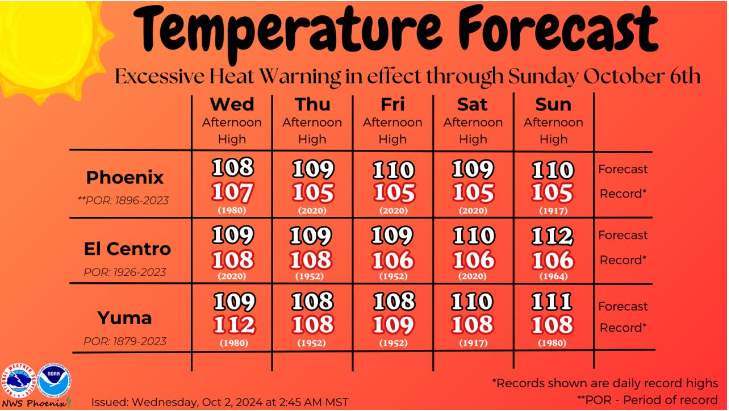
Previous high temperature records for early October are being smashed in states such as Arizona and California. Palm Springs, CA, set a new record high temperature of 47.2 C and Phoenix, AZ, set a record of 45.0 C.
The record at Phoenix is an all-time high for an October and the latest into the year a temperature of 43 C or more has been recorded (it was previously Sept. 19), according to the National Weather Service. Approximately 39 million Americans were under a heat warning on Wednesday.
Further record-setting high temperatures are expected this week.
 More record-setting high temperatures are forecast in the U.S. Southwest, per the National Weather Service Office in Arizona. (Source: National Weather Service Office)
Temperature teeter-totter
Could Canada get into some of that U.S. heat? Next week there is a chance that southern parts of the Prairie provinces could experience a touch of “Aug-tober.”
A change in the jet stream – higher level winds that typically mark the border of areas of warm and colder air in the atmosphere – will see a ridge develop northward over the Canadian Prairies while a trough dips southward into eastern Canada.
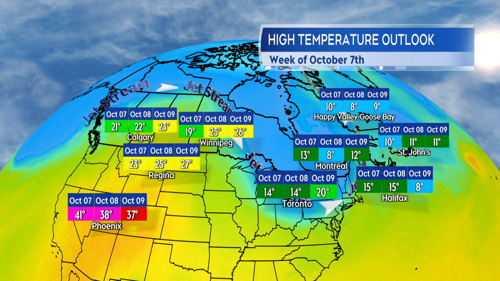
Under the ridge a southerly wind will bring some of the very warm air in the U.S. Southwest northward. Some long-range forecast guidance indicates it may be enough to push high temperatures towards the mid-to-high 20s in parts of southern Alberta, Saskatchewan, and Manitoba Tuesday and Wednesday. Those high temperatures would be near 10 degrees above early October averages for that part of the country.
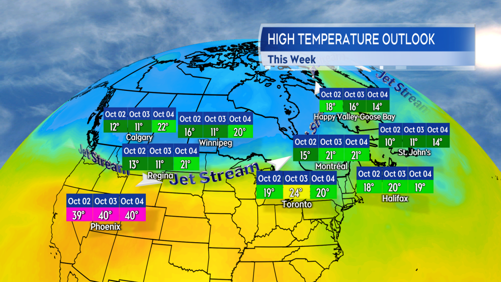
 A touch cool in parts of the west while milder in the east this first week of October. (Source: CTV News Atlantic)
In the meantime, eastern parts of the country that enjoyed a mild start to October get a taste of cooler Autumn air. High temperatures in parts of Ontario, Quebec, and Atlantic Canada lowering into a range of the high-single digits to mid-teens. It should be noted that in many cases that level of temperature is seasonable to just a touch below for early October.
 A reversal next week as the east cools and parts of the west could experience temperatures climbing well above seasonable. (Source: CTV News Atlantic)
Early October heat records in Canada
There is a chance southern parts of the Prairies could approach standing daily high temperature records next week. That will depend on just how much of a push the warmer air in the U.S. gets northward. It has been plenty warm in early October in years past for the southern Prairies.
If we look at Oct. 9, the standing high temperature record for Winnipeg is 27.8 C, set in 1938. For Regina, Saskatchewan, it is 30.1 C, set in 1910. The record daily high temperature for Calgary is 25.4 C, which was set in 2023.
Despite the warm up, most long-range weather models indicate temperatures falling short of those standing records at this time.
CTVNews.ca Top Stories

opinion Tom Mulcair: Prime Minister Justin Trudeau's train wreck of a final act
In his latest column for CTVNews.ca, former NDP leader and political analyst Tom Mulcair puts a spotlight on the 'spectacular failure' of Prime Minister Justin Trudeau's final act on the political stage.
B.C. mayor gets calls from across Canada about 'crazy' plan to recruit doctors
A British Columbia community's "out-of-the-box" plan to ease its family doctor shortage by hiring physicians as city employees is sparking interest from across Canada, says Colwood Mayor Doug Kobayashi.
'There’s no support': Domestic abuse survivor shares difficulties leaving her relationship
An Edmonton woman who tried to flee an abusive relationship ended up back where she started in part due to a lack of shelter space.
opinion King Charles' Christmas: Who's in and who's out this year?
Christmas 2024 is set to be a Christmas like no other for the Royal Family, says royal commentator Afua Hagan. King Charles III has initiated the most important and significant transformation of royal Christmas celebrations in decades.
Baseball Hall of Famer Rickey Henderson dead at 65, reports say
Rickey Henderson, a Baseball Hall of Famer and Major League Baseball’s all-time stolen bases leader, is dead at 65, according to multiple reports.
Arizona third-grader saves choking friend
An Arizona third-grader is being recognized by his local fire department after saving a friend from choking.
Germans mourn the 5 killed and 200 injured in the apparent attack on a Christmas market
Germans on Saturday mourned the victims of an apparent attack in which authorities say a doctor drove into a busy outdoor Christmas market, killing five people, injuring 200 others and shaking the public’s sense of security at what would otherwise be a time of joy.
Blake Lively accuses 'It Ends With Us' director Justin Baldoni of harassment and smear campaign
Blake Lively has accused her 'It Ends With Us' director and co-star Justin Baldoni of sexual harassment on the set of the movie and a subsequent effort to “destroy' her reputation in a legal complaint.
Oysters distributed in B.C., Alberta, Ontario recalled for norovirus contamination
The Canadian Food Inspection Agency has issued a recall due to possible norovirus contamination of certain oysters distributed in British Columbia, Alberta and Ontario.


