Cold snap brings back risk of snow squall
 A couple walks through a frozen landscape. (Source: AP Photo/Seth Wenig)
A passing cold front will drop low temperatures several degrees below late November averages Friday night.
The colder northwest wind travelling over relatively warmer ocean waters will bring areas of flurries and localized snow squalls onshore Friday night into Saturday afternoon.
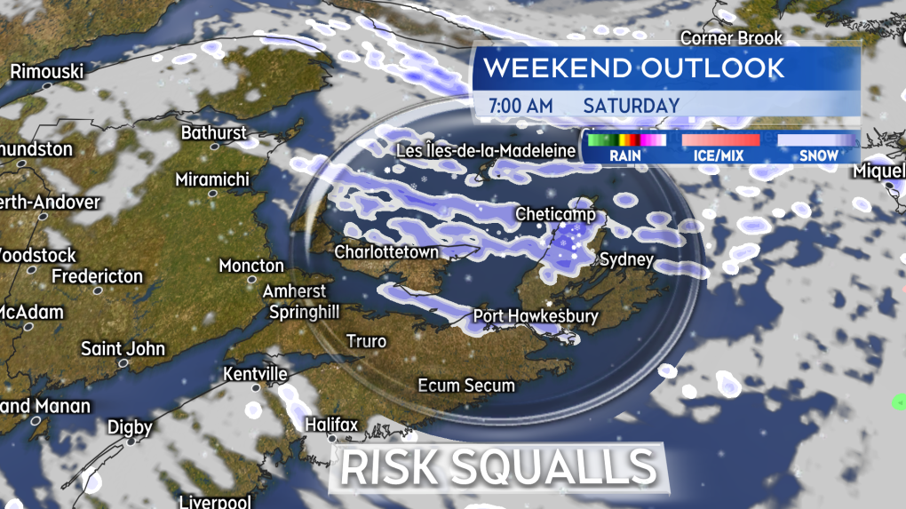
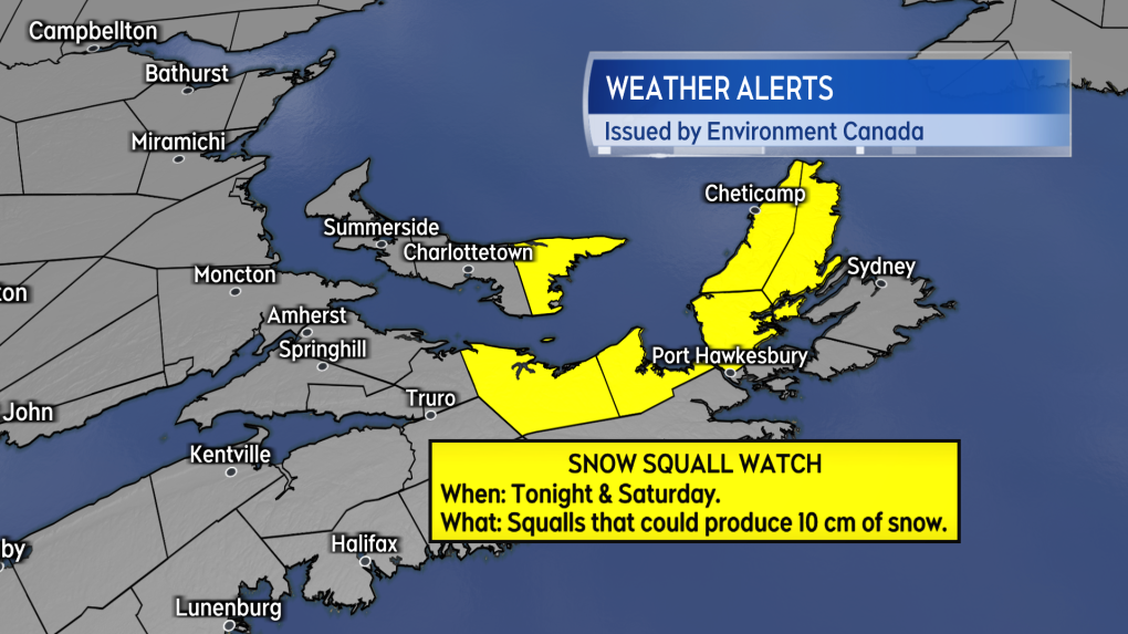
The areas at most risk of snow squalls include the Magdalen Islands, eastern P.E.I., the North Shore of mainland Nova Scotia, and Inverness/Victoria counties of Cape Breton. These areas are under a snow squall watch by Environment Canada, which cautions that localized squalls could produce snow totals ranging several to near 10 cm.
I’d also include a lower risk for Digby, Yarmouth, and Shelburne counties in southwestern Nova Scotia. Flurries and squalls there would by off the Bay of Fundy.
This is not an unusual weather occurrence this time of the year. The fall season sets us up perfectly for instances of snow squalls as more frequent rounds of cold air break out southward from the Arctic and the ocean water have not become chilled or ice covered yet.
The cold air keeps high temperatures below freezing on Saturday. Low temperatures Saturday night will range from -6 C to -10 C for much of the Maritimes. High temperatures on Sunday will moderate into the low-to-mid single digits.
Temperatures get another bump up on Monday but only due to a low pressure system returning rain to the Maritimes. Some snow is possible in northern New Brunswick with that next system.

Shopping Trends
The Shopping Trends team is independent of the journalists at CTV News. We may earn a commission when you use our links to shop. Read about us.


CTVNews.ca Top Stories

New rules clarify when travellers are compensated for flight disruptions
The federal government is proposing new rules surrounding airlines' obligations to travellers whose flights are disrupted, even when delays or cancellations are caused by an "exceptional circumstance" outside of carriers' control.
B.C. mayor gets calls from across Canada about 'crazy' plan to recruit doctors
A British Columbia community's "out-of-the-box" plan to ease its family doctor shortage by hiring physicians as city employees is sparking interest from across Canada, says Colwood Mayor Doug Kobayashi.
Arizona third-grader saves choking friend
An Arizona third-grader is being recognized by his local fire department after saving a friend from choking.
opinion
opinion Tom Mulcair: Prime Minister Justin Trudeau's train wreck of a final act
In his latest column for CTVNews.ca, former NDP leader and political analyst Tom Mulcair puts a spotlight on the 'spectacular failure' of Prime Minister Justin Trudeau's final act on the political stage.
Baseball Hall of Famer Rickey Henderson dead at 65, reports say
Rickey Henderson, a Baseball Hall of Famer and Major League Baseball’s all-time stolen bases leader, is dead at 65, according to multiple reports.
Germans mourn the 5 killed and 200 injured in the apparent attack on a Christmas market
Germans on Saturday mourned the victims of an apparent attack in which authorities say a doctor drove into a busy outdoor Christmas market, killing five people, injuring 200 others and shaking the public’s sense of security at what would otherwise be a time of joy and wonder.
Albania to close TikTok for a year blaming it for promoting violence among children
Albania's prime minister said Saturday the government will shut down the video service TikTok for one year, blaming it for inciting violence and bullying, especially among children.
London Ont. Liberal MPs say that Trudeau is taking time to reflect on his future
Both of London’s Liberal MPs are choosing their words carefully when it comes to their party's leadership future. They were asked about the situation in Ottawa at Friday's housing announcement in London.
Music maker, 88, creates unique horn section, with moose antler bass guitar and cello
Eighty-eight-year-old Lorne Collie has been making musical instruments for more than three decades, creations that dazzle for their unique materials as much as their sound.
Toronto
-

'A protracted altercation': Toronto police investigating homicide in Corso Italia
A 21-year-old man is dead after an altercation involving no less than five people broke out in Toronto’s Corso Italia neighbourhood overnight, police say.
-
Police release photo of suspect vehicle in Scarborough drive-by shooting
Toronto police have released a photo of a suspect vehicle wanted in connection with the fatal drive-by shooting in Scarborough earlier this week.
-
Toronto opens 2 more warming centres as temps dip below -15 C
Toronto is opening two additional warming centres at 5 p.m. on Saturday to support people experiencing homelessness as the temperature is expected to dip to a chilly -15 C.
Calgary
-

Icy conditions: Alberta RCMP warn of poor driving conditions on QEII between Leduc and Red Deer
Alberta RCMP issued a warning to drivers Saturday morning about slick conditions on the QEII between Leduc and Red Deer.
-
Baseball Hall of Famer Rickey Henderson dead at 65, reports say
Rickey Henderson, a Baseball Hall of Famer and Major League Baseball’s all-time stolen bases leader, is dead at 65, according to multiple reports.
-
Search of suspicious vehicle in south Lethbridge leads to seizure of drugs, cash
A 28-year-old woman has been charged after a search of a suspicious vehicle led to the seizure of drugs and cash.
Edmonton
-

'There’s no support': Domestic abuse survivor shares difficulties leaving her relationship
An Edmonton woman who tried to flee an abusive relationship ended up back where she started in part due to a lack of shelter space.
-
3 provincial departments at risk for unauthorized access to personal information: Alberta's Auditor General
A report from Alberta’s Auditor General flags loose network controls in three Government of Alberta departments as potential risks for unauthorized access to government data and Albertans’ personal information.
-
Icy conditions: Alberta RCMP warn of poor driving conditions on QEII between Leduc and Red Deer
Alberta RCMP issued a warning to drivers Saturday morning about slick conditions on the QEII between Leduc and Red Deer.
Montreal
-

Montreal vintage store co-owners find new life in second-hand fashion
After developing an online shopping addiction, Montrealer Jessica Yaffe said she discovered the world of second-hand clothing.
-
Canada Post says many parcels held up by strike to arrive before Christmas
Canada Post says it has processed its backlog of parcels from the month-long strike and expects a significant portion of them to be delivered before Christmas.
-
Judge sentences Quebecer convicted of triple murder who shows 'no remorse'
A Quebecer convicted in a triple murder on Montreal's South Shore has been sentenced to life in prison without chance of parole for 20 years in the second-degree death of Synthia Bussieres.
Ottawa
-

Deep freeze hits Ottawa on first day of winter
Saturday is the first day of winter and the nation’s capital has hit a deep freeze, with temperatures feeling like minus 24 with the windchill.
-
OPP find wanted man, seize $50K worth of drugs in Bancroft, Ont.
A wanted eastern Ontario man was found with $50,000 worth of drugs and cash on him in a home in Bancroft, Ont. on Friday morning, according to the Ontario Provincial Police (OPP).
-
Here's how you can watch CTV News at Six tonight during the NFL game
With CTV broadcasting tonight's NFL game, CTV News at Six will be broadcasting live on our website and the CTV News App.
London
-

New Canadians displaced after fire destroys east London townhome
A family of new Canadians from Nigeria are looking for a new home just before Christmas. Fire destroyed their townhome on Bentley Drive in northeast London, Ont. Friday night.
-
Feeling Festive? Check out this display of over 300 lit Christmas trees
“We have over 300 Christmas trees on display, the majority of them are sponsored and decorated by all of our amazing local businesses,” says Ashley Mason, event and hospitality manager at CASO Station and ECRM in St. Thomas, Ont.
-
Sarnia Police Auxiliary Unit works to return stolen shopping carts to businesses
The high cost of crime is often passed on to consumers – whether it’s shoplifting, vandalism or property damage.
Barrie
-

Snowfall and extreme wind chills expected to mark the first day of winter
Mother Nature is ringing in the first day of winter with a snowy blast, as Environment Canada issued a weather advisory for parts of the region on Saturday.
-
High school teacher charged with sexual assault amid allegations involving a student
A 51-year-old teacher from Georgina has been charged with sexual assault following allegations involving a student.
-
One driver faces several charges following Highway 400 crash in Oro-Medonte
Traffic came to a standstill Friday afternoon following a single-vehicle collision on Highway 400 in Oro-Medonte.
Northern Ontario
-

Robinson Superior First Nations provided settlement offer from Canada over annuities owed
Details haven’t been made public yet about the settlement offer presented on Friday by Canada to the 12 First Nations in the Robinson Superior Treaty Territory.
-
Northern Ont. man illegally killed three moose, one deer
A man from the northwestern Ontario community of Dinorwic has been found guilty of multiple hunting offences and fined $6,500, banned from hunting for five years and placed on probation for 18 months.
-
opinion
opinion Tom Mulcair: Prime Minister Justin Trudeau's train wreck of a final act
In his latest column for CTVNews.ca, former NDP leader and political analyst Tom Mulcair puts a spotlight on the 'spectacular failure' of Prime Minister Justin Trudeau's final act on the political stage.
Kitchener
-

Hydro out in Listowel following collision
Police say a collision between a vehicle and hydro box happened Saturday morning and as a result, hydro is out in the town of Listowel.
-
Suspect sought in Paris, Ont. assault investigation
The Brant County Ontario Provincial Police responded to a reported assault on Scott Avenue in Paris just before 10 p.m. on Dec. 9.
-
Youth arrested for assault with a weapon in Kitchener
Waterloo Regional Police have arrested and charged a youth after a group of minors walked into a public school and assaulted a staff member.
Windsor
-

'Heartwarming': Windsor-Essex families receive help filling underneath the tree
Space under the Christmas tree became far more limited for several Windsor-Essex families who received a visit from volunteers at Project Christmas.
-
'It's got to stop, it's that simple': Windsor cab drivers warn of unregulated operators
Drivers now compete with individuals using social media to advertise rides at cut-rate prices. One person offers $10 rides within the city, while another promotes daily trips from Windsor to Toronto for $45 per person.
-
Windsor-Essex toes the threshold of a cold warning, with temperatures set to plunge tonight
It’s going to be bitterly cold outside overnight on Saturday, although we will remain just under the threshold for an official cold warning from the health unit.
Winnipeg
-

Residential parking ban lifted in Winnipeg
The City of Winnipeg has lifted its parking ban on residential streets.
-
Bail denied for Winnipeg woman accused of killing animals in online videos
Warning: This story contains disturbing details. Discretion is advised. A Winnipeg woman accused of making videos of animals being tortured and killed that were sold on the dark web was denied bail.
-
Ace Burpee's Top 100 Most Fascinating Manitobans of 2024
It’s been another year of Manitobans doing interesting, incredible and cool things. The hardest part of compiling this list is cutting it off at 100.
Regina
-

Gravelbourg's transportation program celebrates addition of new vehicle and garage
The town of Gravelbourg is celebrating the addition of a new vehicle and garage which will be used in their local transportation program.
-
Canora celebrates new school cooking program
Students in Canora are getting a tasteful educational experience through their newly commercial cooking program.
-
'A sense of holiday spirit': Local shelter hosts Regina's most vulnerable at annual Christmas dinner
For nearly 35 years, Souls Harbour Rescue Mission has been serving an annual Christmas dinner to Regina’s most vulnerable.
Saskatoon
-

Sask. lawyers defend judge for staying fatal THC-impaired driving charge
The Saskatchewan Trial Lawyers Association is defending a provincial court judge, who’s facing backlash for staying a charge in a high-profile case involving the death of a child.
-
Sask. police investigating mischief incident after bomb report in school
Prince Albert police are investigating a mischief incident after a bomb report in a school Friday afternoon.
-
Prince Albert woman collects donations to make Christmas hampers for community
A Prince Albert woman is spreading holiday cheer by organizing Christmas hampers for those in need.
Vancouver
-
 DEVELOPING
DEVELOPING Police responding to 'shooting incident' in Mission, B.C.
First responders are at the scene of a “shooting incident” in the Lower Mainland city of Mission Saturday morning, Mounties confirmed.
-
Environment Canada issues warnings as more high winds expected along B.C. coast
Residents of parts of the British Columbia coast are again bracing for high winds, with gusts forecasted to reach 110 km/h in some areas.
-
2 dead after car crash in Burnaby
Two people were killed in a car crash in Burnaby early Saturday morning, police confirmed.
Vancouver Island
-

B.C. mayor gets calls from across Canada about 'crazy' plan to recruit doctors
A British Columbia community's "out-of-the-box" plan to ease its family doctor shortage by hiring physicians as city employees is sparking interest from across Canada, says Colwood Mayor Doug Kobayashi.
-
B.C. woman with photographic memory strives to make unforgettable Christmas displays
Although Alisha Pauling is looking through old pictures, she doesn’t need them to remember her Christmases past. She has a photographic memory.
-
Internet stranger's kind gesture restores Canucks fan's faith in humanity
A Nanaimo, B.C., couple is in awe at the kindness of an internet stranger who helped them track down a coveted Christmas gift.
Kelowna
-

Forfeited Hells Angels clubhouse in Kelowna, B.C., sold to the city
A former Hells Angels clubhouse that was seized by the British Columbia government in 2023 after years of fighting in court has been sold to the City of Kelowna.
-
Death of woman found in Kelowna's Waterfront Park in June deemed 'non-criminal in nature': RCMP
Police in Kelowna say a death they began investigating back in June has now been confirmed as "non-criminal in nature."
-
B.C. man sentenced for 'execution-style' murder of bystander in drug trade conflict
A B.C. man convicted of the "intentional and ruthless killing of a bystander" while acting as an enforcer in the drug trade has been sentenced for a second time in the slaying.


