How snow around the Great Lakes plays role in late-week Maritime storm
An early season outbreak of frigid Arctic air triggered a severe round of lake effect snow around the Great Lakes. Even as that situation improves, the lingering cold air will provide fuel for an early December storm that will impact Atlantic Canada late this week.
Lake effect snow summary
Snow has piled up around parts of the Great Lakes since last Wednesday. The town of Gravenhurst in the Muskoka Bay area has seen an unofficial 140 cm or 4.5 feet of snow. Barnes Corners in upstate New York cleared 160 cm or more than five feet of snow. Areas just to the south of Buffalo also saw snow totals of more than 130 cm or four-plus feet.
The significance of this type of lake effect snow depends on a few factors. The temperature difference between the lake water and air aloft is one. The second is the “fetch” or distance the prevailing wind runs over the lake water. It was a bullseye for both of those factors.
The lake waters are running warmer than typical. Analysis from the National Ocean and Atmospheric Administration puts parts of the lakes sitting at roughly two-to-five degrees above average for this time of the year. An early season bite of Arctic air – cold enough that it triggered extreme cold warnings in Saskatchewan and Manitoba last week – was then enough for the snow to develop and move onshore. A prolonged period of westerly winds then allowed those bands of snow to add up over the same areas and communities for several days.
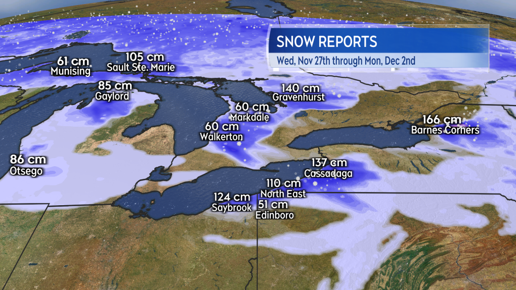 Some reported snow totals Wednesday through Monday around the Great Lakes. (Source: CTV News Atlantic)
Situation and warnings continue
Snow Squall Warnings remain in effect along the eastern side of Lake Huron from near Barrie, Ontario south to near Warwick, Ontario. While the intense bands of snow are very localized, that could bring another 30-to-60 cm Monday through Tuesday morning. Environment Canada recommend travel be postponed through impacted areas and further power outages are a risk due to the heavy nature of the snow.
A strengthening low-pressure system moving out of the Prairies will arrive in northern Ontario late Tuesday. The arrival of that weather system will bring a change in wind direction enough to disrupt the lake snow for Wednesday. It does look likely that bands of lake snow will redevelop in the passage of that low-pressure system late Thursday into Friday.
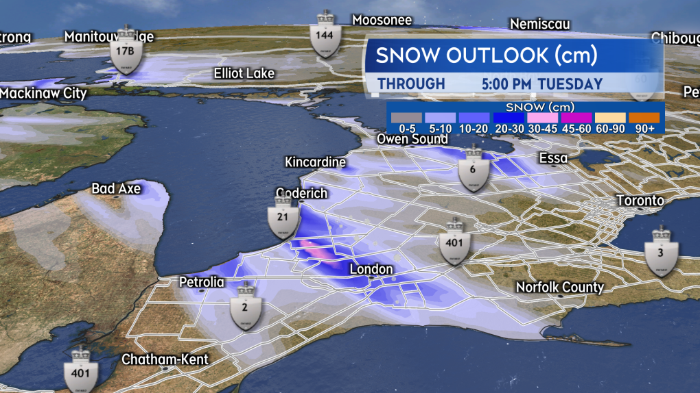 Snow Squall Warnings continue for parts of southern Ontario as localized bands of snow off of Lake Huron may total another 30+ cm for some communities through Tuesday morning. (Source: CTV News Atlantic)
Cold air fuel for early December storm
The low-pressure system moving out of the Prairies will further strengthen into an early December storm as it moves from Quebec into New Brunswick on Thursday. The storm will be fueled by the temperature difference created between the cold air over the Great Lakes and milder air positioned near the Atlantic seaboard.
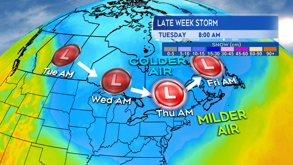 A low out of the Prairies running along the border of the colder air may bring stormy conditions to parts of Atlantic Canada late this week. (Source: CTV News Atlantic)
Parts of Northern Ontario and western Quebec will pick up snow amounts of 10-to-20 cm Tuesday night through early Thursday morning.
Snow amounts ranging 15-to-30 cm could fall from northern New Brunswick, across the Gaspe Peninsula and Anticosti Island of Quebec, north shore of the St. Lawrence River in Quebec, and into southeastern Labrador. That would be from Thursday through late Friday for those areas.
The remainder of the Maritimes and Newfoundland more likely to see a mix of snow and rain. Rain amounts of 15-to-40 mm look likely at this time.
Due to the expected strength of the system, winds could approach warning criteria in parts of Atlantic Canada. That looks most likely for eastern Nova Scotia and parts of Newfoundland late Thursday into early Friday morning. Ferry travel services in the region are very likely to be disrupted.
CTVNews.ca Top Stories

Much of Canada is under an extreme weather alert this weekend: here's what to know
From snow, to high winds, to extreme cold, much of Canada is under a severe weather alert this weekend. Here's what to expect in your region.
Calgary woman stranded in Mexico after husband's death during diving trip
A Calgary woman is struggling to return home after her husband died while diving in Mexico, leaving her stranded and facing financial hardship.
Fugitive U.S. rioter seeks asylum in Whistler amid warnings of more to come
An American citizen convicted of participating in the Jan. 6, 2021, riot on Capitol Hill and dodging jail time in Whistler may just be the start of an asylum-seeking rush, according to a prominent legal expert.
'I gave them a call, they didn't pick up': Canadian furniture store appears to have gone out of business
Canadian furniture company Wazo Furniture, which has locations in Toronto and Montreal, appears to have gone out of business. CTV News Toronto has been hearing from customers who were shocked to find out after paying in advance for orders over the past few months.
Soldier who died by suicide in Las Vegas told ex-girlfriend of pain and exhaustion after Afghanistan
The highly decorated Special Forces soldier who died by suicide in a Cybertruck explosion on New Year's Day confided to a former girlfriend who had served as an Army nurse that he faced significant pain and exhaustion that she says were key symptoms of traumatic brain injury.
Man arrested after committing five bank robberies in 10 days: Toronto police
A man accused of robbing five Toronto-area banks in a 10-day period has been arrested by Toronto police.
Jimmy Carter's state funeral starts Saturday. Here is what to know
Six days of funeral observances for former President Jimmy Carter begin Saturday in Georgia, where he died on Dec. 29 at the age of 100.
Special national Liberal caucus meeting called for next week after regional chairs meet: sources
A special meeting of Prime Minister Justin Trudeau's national Liberal caucus has been called for next Wednesday, sources say.
'Support better care': Advocates argue need for mental health emergency service
The crisis service sees two mental health clinicians respond to well-being checks without police. Calls are received through 211 or 911, and workers are dispatched if there aren't immediate public safety or medical concerns.


