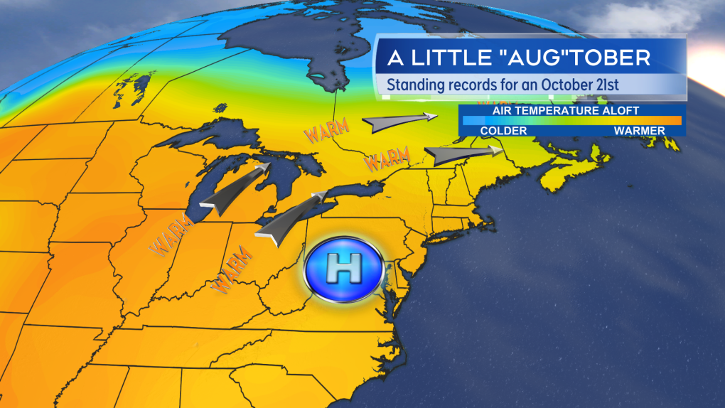
Maritime October temperatures soar to record highs while snow falls in the west
Communities east of Alberta set record high temperatures for an Oct. 21 while Alberta itself contended with the first snowfall of the season in some areas.
Monday record highs
High temperature records were set in all three Maritime provinces on Monday.
Record high temperatures were also found in southern areas of Saskatchewan and Manitoba. The warmest temperature in the county on Monday, according to Environment Canada-monitored weather stations, was at Egbert, Ontario, which reached 26.4 degrees. In the Maritimes it was a two-way tie between Upper Stewiacke and Western Head, which both reached 22.5 degrees.
Calgary’s temperature fell to near -3 C in the afternoon with snow falling and accumulating. Observers reported two-to-six centimetres of snow around the city.
 New daily high temperature records for an Oct. 21 set in the Maritimes on Monday. (Source: CTV News Atlantic)
What goes up must come down
The snowy October weather in Alberta was a result of a cold front and trough in the jet stream. That pattern will continue to move west-to-east across the country, lowering temperatures as it goes along.
Tuesday afternoon temperatures in Saskatchewan and Manitoba are expected to be mostly in the range of the low-to-mid single digits. Overnight low temperatures will fall to or below freezing. A mix of showers and flurries will move through.
The snap back to cooler October weather arrives for Ontario and Quebec Wednesday and Thursday. The Maritimes will cool Thursday into Friday.
High temperatures on Friday for the Maritimes are mostly expected to range eight-to-12 degrees, which is very close to average for late October.
 A cold front and trough (dip southward) in the jet stream is returning cooler October weather west-to-east across the country. (Source: CTV News Atlantic)
Tropical Storm Oscar
Tropical Storm Oscar is moving northeast, away from the southeastern Bahamas and Turks and Caicos Islands on Tuesday.
The system has become more disorganized and the National Hurricane Center says it is barely meeting the criteria of a tropical storm.
Oscar is expected to become a remnant area of low pressure as it moves northward just to the west of Bermuda Wednesday night.
There is a low chance of some rain or showers from the system brushing eastern Nova Scotia on Thursday. There is a higher chance heavier rain from the remnants of the system reaches eastern Newfoundland Thursday night and Friday. The Burin, Bonavista, and Avalon Peninsulas could get into some rain totalling 50-to-100+ mm.
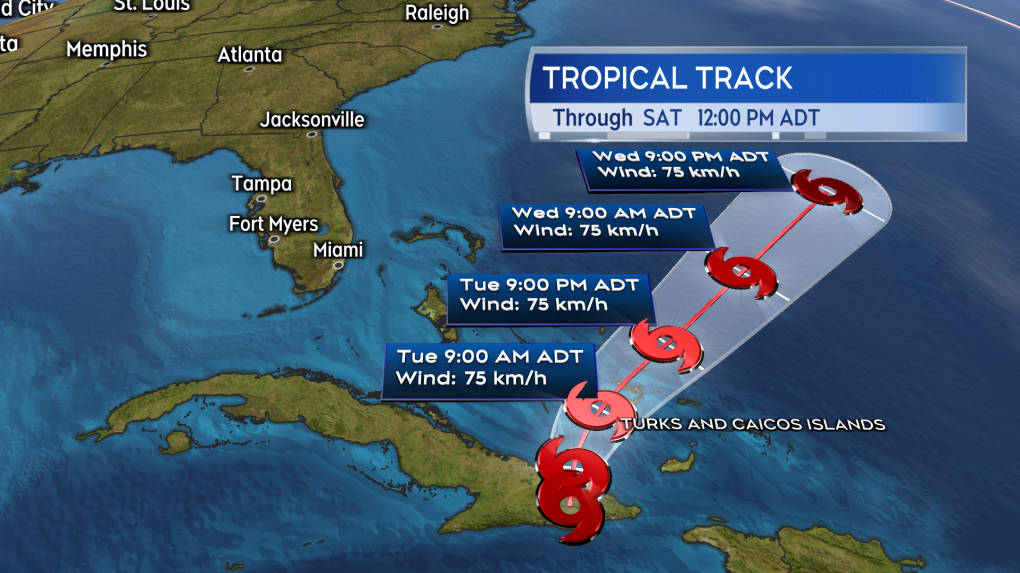 Oscar is becoming a non-tropical area of low pressure. Heavy rain from the remnants could reach eastern Newfoundland Thursday night and Friday. (Source: CTV News Atlantic)
Shopping Trends
The Shopping Trends team is independent of the journalists at CTV News. We may earn a commission when you use our links to shop. Read about us.


CTVNews.ca Top Stories

Singh says the NDP 'will vote to bring this government down' in new letter
After months of being non-committal, in a new letter, NDP Leader Jagmeet Singh says his caucus 'will vote to bring this government down,' sometime in 2025.
WATCH LIVE
WATCH LIVE 'I understand there's going to be a short runway,' new minister says after Trudeau shuffles cabinet
Prime Minister Justin Trudeau added eight Liberal MPs to his front bench and reassigned four ministers in a cabinet shuffle in Ottawa on Friday, but as soon as they were sworn-in, they faced questions about the political future of their government, and their leader.
Weather alerts in effect across Canada: Freezing rain, snow, extreme cold
Environment Canada has issued a series of winter weather alerts from Edmonton to St. John's as freezing rain, snow squalls and extreme cold blanket parts of the country.
Is the Norad Santa tracker safe from a U.S. government shutdown?
The military's tradition of tracking Santa Claus on his gravity-defying sweep across the globe will carry on this Christmas Eve, even if the U.S. government shuts down, officials said Friday.
Joss Stone says she's discovered she's pregnant – just weeks after adopting a baby
Joss Stone has revealed that she is pregnant, just weeks after she and her husband adopted a baby boy.
A new book about Chrystia Freeland just came out. Here's what we learned
A new book about Chrystia Freeland has just come out, after the publishing company sped up its release date by a few months. CTV News sifted through the book and pulled out some notable anecdotes, as well as insights about Freeland's relationship with the prime minister.
Guelph man facing assault charge after police say he spat in roommate's face during disagreement over cat
A fight between roommates has led to an assault charge for a Guelph man.
Quebecer convicted of killing partner, two children sentenced
A Quebecer convicted in a triple murder on Montreal's South Shore has been sentenced to life in prison without chance of parole for 20 years in the second-degree death of Synthia Bussieres.
U.S. recalls 600K car seats, fix available to Canadians
Nuna Baby Essentials is recalling nearly 609,000 child car seats because the harness adjuster can loosen and the seats may not restrain children.
Toronto
-

'Concerned, frustrated, in fear': Renewed calls for government to address antisemitism after third gunfire incident at Toronto Jewish school
A Jewish elementary school in Toronto has been struck by gunfire for the third time in the last seven months.
-
Streetcar service resumes following 'extensive repairs' at King and Spadina intersection
Streetcar service has resumed at a major downtown intersection that had been closed since a garbage truck took down some overhead wires on Tuesday morning.
-
Police say break-and-enter suspects were in Canada for 'purpose of committing criminal offences'
Five Chilean nationals who police believe were in Canada for 'the purpose of committing criminal offences' have been charged in connection with half a dozen break-and-enters across the Greater Toronto Area (GTA).
Calgary
-

Alberta announces plan to develop 'modernized' coal policy
The future of coal mining in Alberta will be governed by a new, modern approach, the province announced on Friday.
-
Wild boar hybrid identified near Fort Macleod, Alta.
Acting on information, an investigation by the Municipal District of Willow Creek's Agricultural Services Board (ASB) found a small population of wild boar hybrids being farmed near Fort Macleod.
-
Crews respond to two separate fires in south Calgary
Fire crews were busy on Friday morning responding to two separate blazes in south Calgary.
Edmonton
-
 WATCH LIVE
WATCH LIVE 'I understand there's going to be a short runway,' new minister says after Trudeau shuffles cabinet
Prime Minister Justin Trudeau added eight Liberal MPs to his front bench and reassigned four ministers in a cabinet shuffle in Ottawa on Friday, but as soon as they were sworn-in, they faced questions about the political future of their government, and their leader.
-
WEATHER
WEATHER Josh Classen's forecast: Freezing rain risks as the cold spell ends
Flurries and pockets of freezing rain moved through the Edmonton region early this morning.
-
Draisaitl reaches 900-point plateau with three-assist effort in Oilers' 3-2 OT win
When Leon Draisaitl saw teammate Connor McDavid get a silver stick for hitting 1,000 points earlier this season, he clearly wanted one of his own.
Montreal
-

Quebecer convicted of killing partner, two children sentenced
A Quebecer convicted in a triple murder on Montreal's South Shore has been sentenced to life in prison without chance of parole for 20 years in the second-degree death of Synthia Bussieres.
-
Man arrested in Quebec for alleged plot to kill Jews in NYC transferred to Montreal
A Pakistani man arrested in Quebec for an alleged plot to kill Jews in New York City has been transferred to a provincial detention centre in Montreal from Rimouski, Que.
-
Smash and grab caught on camera in Montreal boutique
Montreal designer Jennifer Glasgow is sounding the alarm about break-ins in her neighbourhood after thieves broke into her boutique and made off with clothing and jewelry.
Ottawa
-
 LISTEN
LISTEN Opposition leader speaks with The Morning Rush with Bill Carroll
The leader of the Conservative Party of Canada and the leader of the opposition in the House of Commons commented on multiple key issues Thursday morning in an exclusive interview with The Morning Rush with Bill Carroll.
-
‘Hot and frosty’: Film industry booming in Ottawa
Ottawa is not only a hot spot for tourism, but also a landmark when it comes to the film industry and holiday movies, says the City of Ottawa.
-
OPP charge three former hospital employees with patient privacy breach after unrelated incidents
Three former hospital employees have been charged following investigations into unrelated alleged breach of patient privacy incidents that took place over the course of last year in different parts of the province, according to the Ontario Provincial Police (OPP).
London
-
Manslaughter charge laid against London man after August drug bust
A London man has been charged with manslaughter after an OPP drug raid this summer. Police have released few details but say they used a search warrant at a West Elgin home Aug. 23.
-
Man dies after falling from building: LPS
London police say a man has died after falling from a building.
-
Controversial shoreline development to begin construction in new year
The Town of Saugeen Shores, says it was just notified by the private company building the shoreline retail development, that it plans to start construction early next year.
Barrie
-

High school teacher charged with sexual assault amid allegations involving a student
A 51-year-old teacher from Georgina has been charged with sexual assault following allegations involving a student.
-
Driver charged after vehicle crashes into Barrie home
A driver was arrested Thursday night after a vehicle crashed into a home in Barrie.
-
Sentencing hearing for Barrie man convicted of sex crimes involving a child
A sentencing hearing is being held Friday in a Barrie courtroom for a man convicted of sex crimes involving a child.
Northern Ontario
-
Singh says the NDP 'will vote to bring this government down' in new letter
After months of being non-committal, in a new letter, NDP Leader Jagmeet Singh says his caucus 'will vote to bring this government down,' sometime in 2025.
-
Northern Ont. man illegally killed three moose, one deer
A man from the northwestern Ontario community of Dinorwic has been found guilty of multiple hunting offences and fined $6,500, banned from hunting for five years and placed on probation for 18 months.
-
Ontario town seeks judicial review after being fined $15K for refusing to observe Pride Month
An Ontario community fined $15,000 for not celebrating Pride Month is asking a judge to review the decision.
Kitchener
-

Police believe shots fired into Cambridge home was a targeted incident
Waterloo Regional Police Service now believes shot fired into a Cambridge home was a targeted incident.
-
One arrest, four suspects still wanted for armed robbery at Waterloo jewelry store
New details have been released about a smash-and-grab robbery at a jewelry store in Waterloo.
-
Kitchener man arrested in Chatham-Kent after call about possible abduction
Around 4:45 p.m. on Wednesday, local police were contacted by Peel Regional police and learned a suspect was believed to be in the north and of Chatham.
Windsor
-

Toll increase coming to the Windsor-Detroit Tunnel in 2025
Drivers heading through the Windsor-Detroit Tunnel in the new year will have to take some extra cash. A toll increase for those heading from Canada to the U.S. is scheduled for Jan. 1, 2025 .
-
Life-threatening injuries after ATV crash in Lakeshore
Around 4:20 p.m. on Thursday, police, fir and EMS were called to Lakeshore Road 302 for a crash involving an ATV.
-
Parvovirus claims the lives of more Windsor dogs
An outbreak of canine parvovirus in downtown Windsor has now claimed the lives of 18 dogs, according to a spokesperson for the Ministry of the Solicitor General.
Winnipeg
-

Ontario town seeks judicial review after being fined $15K for refusing to observe Pride Month
An Ontario community fined $15,000 for not celebrating Pride Month is asking a judge to review the decision.
-
Singh says the NDP 'will vote to bring this government down' in new letter
After months of being non-committal, in a new letter, NDP Leader Jagmeet Singh says his caucus 'will vote to bring this government down,' sometime in 2025.
-
Manitoba man wins $40M Lotto Max jackpot with ticket purchased in Alberta
A Manitoba man has won one of the top five largest lottery jackpots in Manitoba history.
Regina
-

Local groups work to give people extra support this holiday season
As the holidays approach, outreach groups are working to give people in the community a bit of extra support.
-
Appeal dismissed in Sask. 'thumbs up' emoji case
An appeal to a legal case that made international headlines has been dismissed by Saskatchewan's highest court.
-
'An absolute blessing': Milgaard's Law receives royal assent, giving hope to the wrongfully convicted
Bill C-40, the Miscarriage of Justice Review Commission Act, better known as David and Joyce Milgaard’s Law, received royal assent Tuesday.
Saskatoon
-

'An absolute blessing': Milgaard's Law receives royal assent, giving hope to the wrongfully convicted
Bill C-40, the Miscarriage of Justice Review Commission Act, better known as David and Joyce Milgaard’s Law, received royal assent Tuesday.
-
Saskatchewan highway closed due to serious collision
The Saskatoon RCMP are currently responding to a serious collision on Highway 5, west of Meacham.
-
How do THC gummies impact driving? Sask. researchers use simulator to find out
Researchers at the University of Saskatchewan are conducting a study to learn how THC edibles impact driving performance.
Vancouver
-

Victoria police make 42 arrests in retail theft crackdown
Police in Victoria say officers have made 42 arrests and recovered approximately $10,000 in stolen merchandise during a four-day retail theft operation targeting repeat offenders.
-
New Westminster man facing multiple counts of sexual assault
A New Westminster, B.C., man is facing multiple charges after a woman he interviewed for a housekeeping job told police she was sexually assaulted in his home.
-
Singh says the NDP 'will vote to bring this government down' in new letter
After months of being non-committal, in a new letter, NDP Leader Jagmeet Singh says his caucus 'will vote to bring this government down,' sometime in 2025.
Vancouver Island
-
Victoria police make 42 arrests in retail theft crackdown
Police in Victoria say officers have made 42 arrests and recovered approximately $10,000 in stolen merchandise during a four-day retail theft operation targeting repeat offenders.
-
Singh says the NDP 'will vote to bring this government down' in new letter
After months of being non-committal, in a new letter, NDP Leader Jagmeet Singh says his caucus 'will vote to bring this government down,' sometime in 2025.
-
New seniors group in Victoria nourishes appetites and souls
A Victoria non-profit known for its work helping the homeless has a new club that’s bursting with joy.
Kelowna
-

Forfeited Hells Angels clubhouse in Kelowna, B.C., sold to the city
A former Hells Angels clubhouse that was seized by the British Columbia government in 2023 after years of fighting in court has been sold to the City of Kelowna.
-
Death of woman found in Kelowna's Waterfront Park in June deemed 'non-criminal in nature': RCMP
Police in Kelowna say a death they began investigating back in June has now been confirmed as "non-criminal in nature."
-
B.C. man sentenced for 'execution-style' murder of bystander in drug trade conflict
A B.C. man convicted of the "intentional and ruthless killing of a bystander" while acting as an enforcer in the drug trade has been sentenced for a second time in the slaying.


