Maritime weekend weather: Cold start and snowy finish
Colder temperatures lie ahead for the weekend in the Maritimes with another swipe of snow and rain expected Sunday.
Thursday storm reports
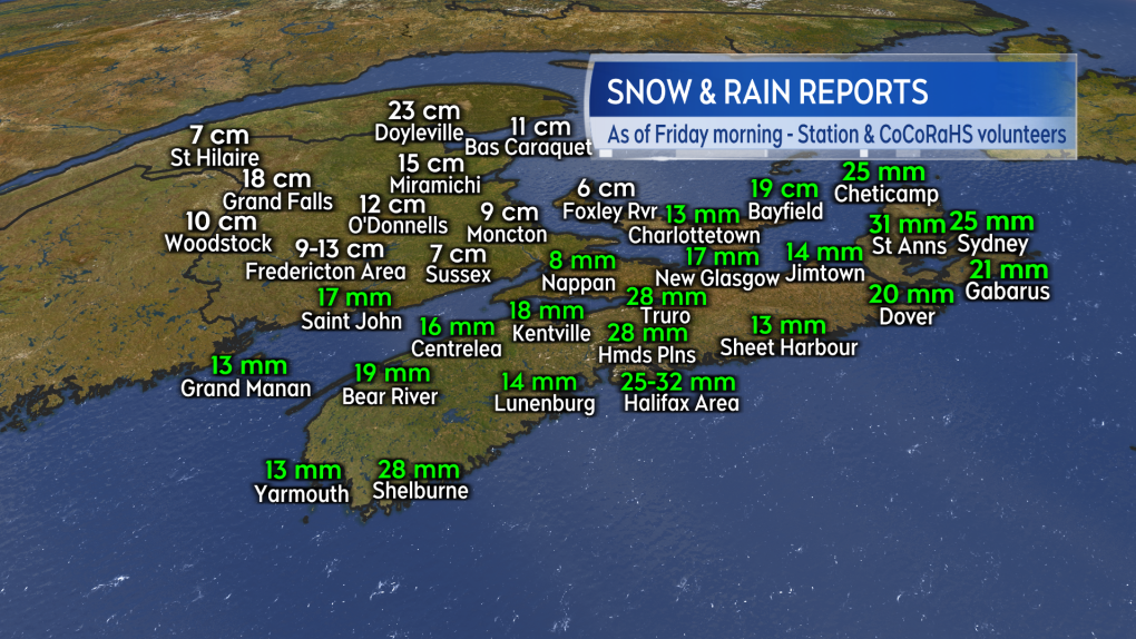
As expected, New Brunswick caught the lion’s share of snow on Thursday. Reports from northern areas of the province totalled 15-to-22 cm. Snow amounts are lower in the south of the province with more rain mixing in.
Snow also started in areas of Nova Scotia and Prince Edward Island on Thursday morning before changing to rain. The snow, when combined with cold surfaces, created slick road conditions. Total precipitation for those province combining snow and rain totalled a general 10-to-32 mm.
Wind gusts at Plateau in Inverness, Cape Breton clocked in at 135 km/h. Gusts on the Atlantic coastline of Nova Scotia reached 80-to-90 km/h and peak gusts near 80 km/h were reported at coastal areas of Prince Edward Island.
 Snow and combined snow-rain reports from select sites in the Maritimes. (Source: CTV News Atlantic)
Cold and snow squalls
It will be a chilly Friday for the Maritimes with a gusty westerly wind keeping afternoon temperatures near and below freezing.
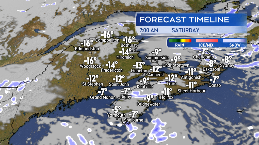
Temperatures continue to plummet Saturday night with low temperatures of -7 C to -14 C for much of the region except closer to -16 C in northern areas of New Brunswick. High temperatures on Saturday will be -4 C to -8 C for most except -2 C to -4 C on the Atlantic coastline of Nova Scotia.
 An early season taste of bitter cold for the Maritimes Friday night and Saturday. (Source: CTV News Atlantic)
The wind will ease a bit for Saturday with gusts falling into a range of 20-to-40 km/h. It will still be breezy enough to add a bit of extra bite to the air.
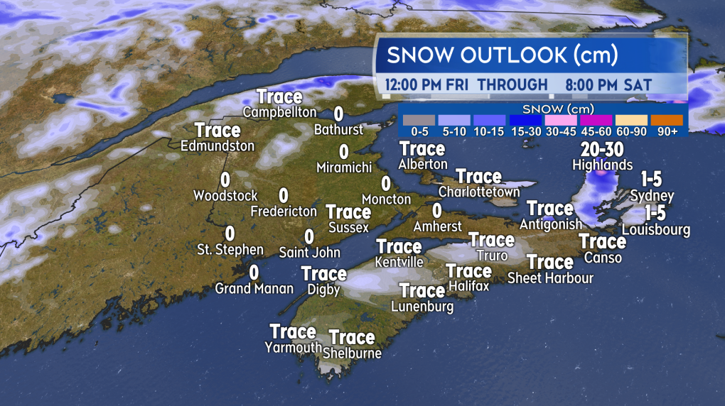
Where the cold wind is blowing in off ocean waters, flurries and snow squalls are possible. The most intense snow squall activity expected in northern Inverness County, Cape Breton where the Highlands could pick up 20-to-30 cm of snow Friday through Saturday. A snow squall watch in effect for the area.
Other areas such as the North Shore of mainland Nova Scotia, Annapolis Valley, Digby/Yarmouth Counties, and eastern Prince Edward Island could also pick up snow totals ranging from a few to several centimetres over that period of time.
 The cold westerly wind will carry flurries and snow squalls onshore for parts of the Maritimes. Inverness County, Cape Breton with the highest risk of prolonged snow squalls. (Source: CTV News Atlantic)
Sunday snow and rain
A fast moving Alberta Clipper will return a mix of snow and rain to the Maritimes on Sunday.
Snow is expected to start in the west of the region Sunday morning and quickly spread to eastern parts by early afternoon. A change to rain in the afternoon is likely for Nova Scotia and eastern Prince Edward Island.
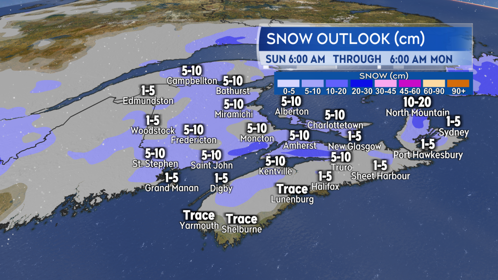
Snow amounts could range from five-to-10 cm for much of the Maritimes. Snow totals lower where a change to rain takes place. Some of the higher elevations of New Brunswick could pick up locally higher amounts of 10-to-15 cm.
If you have travel plans on Sunday, keep on top of the forecast as it looks like enough to create snowy, slippery road conditions.
 A fast moving low pressure system brings a widespread 5 to 10 cm of snow to the Maritimes Sunday. Lower amounts where a change to rain takes place, mostly for Nova Scotia. (Source: CTV News Atlantic)
CTVNews.ca Top Stories

Justin Trudeau's set to go after the Liberals pick his replacement, what now?
Prime Minister Justin Trudeau, announcing Monday that he intends to resign as Liberal leader and prime minister as soon as his party names his replacement, has set a series of political machinations in motion.
Justin Trudeau steps down as Liberal leader. Who are the top contenders to replace him?
With Prime Minister Justin Trudeau's resignation as Liberal party leader, several well-known political faces may be waiting in the wings for their opportunity to take his place.
'Together, what a great nation it would be': Donald Trump, Elon Musk react to Justin Trudeau's resignation
Amid news of Prime Minister Justin Trudeau's resignation as leader of the Liberal party on Monday morning, reactions from prominent figures began piling in.
Strong earthquake kills at least 95 people in western China near Mount Everest
A strong earthquake shook a high-altitude region of western China and areas of Nepal on Tuesday, damaging hundreds of houses, littering streets with rubble and killing at least 95 people in Tibet.
Doug Ford snaps back at Donald Trump's Canada taunts with offer to 'buy Alaska'
Ontario Premier Doug Ford has snapped back at Donald Trump’s frequent taunts about treating Canada as a U.S. state with a counterproposal: buying Alaska.
Calgary's lone Liberal MP thanks Trudeau, but says it was time for him to go
Justin Trudeau's announcement on Monday that he intends to resign as prime minister and Liberal leader was needed 'to move our country forward,' says Calgary's only Liberal MP.
Trudeau says Parliament is 'prorogued' until March. What does that mean?
In his resignation speech on Monday, Prime Minister Justin Trudeau announced that Parliament would be prorogued until March, which will give the Liberal party time to find a new leader ahead of an expected confidence vote and early election.
Trudeau resignation: recap key moments, analysis, reaction as it happened
Prime Minister Justin Trudeau has stepped down as Liberal leader. Here's a recap of key moments, analysis, and reaction as it happened.
Justin Trudeau is resigning after an historic political tenure, here's a look back at his career-defining moments
In a seismic political move, Justin Trudeau has announced his intention to step down as leader of the Liberal Party of Canada and prime minister, once his successor is named. This decision comes after more than nine years in the country's top job and nearly 12 years at the helm of his party.


