Rainy Tuesday for the Maritimes; Hurricane Milton update
A band of rain continues to move slowly across the Maritimes. Hurricane Milton is forecasted to remain a major hurricane with severe weather impacts in Florida.
Rainy Tuesday
A slow-moving weather front moving in from the west continues to push through rain for the Maritimes.
There remains a risk of localized downpours within the rain with the chance of downpours highest in New Brunswick and western Nova Scotia Tuesday afternoon. The risk of downpours moves to eastern Nova Scotia and Prince Edward Island Tuesday evening. The last of the rain is expected to clear Cape Breton early Wednesday morning.
Parts of western New Brunswick and western Nova Scotia have reported some rain amounts of five-to-15 millimetres. In most cases, another five-to-15 millimetres of rain can be expected. Any occurring downpours could help produce further localized rain totals of 15-to-40 millimetres.
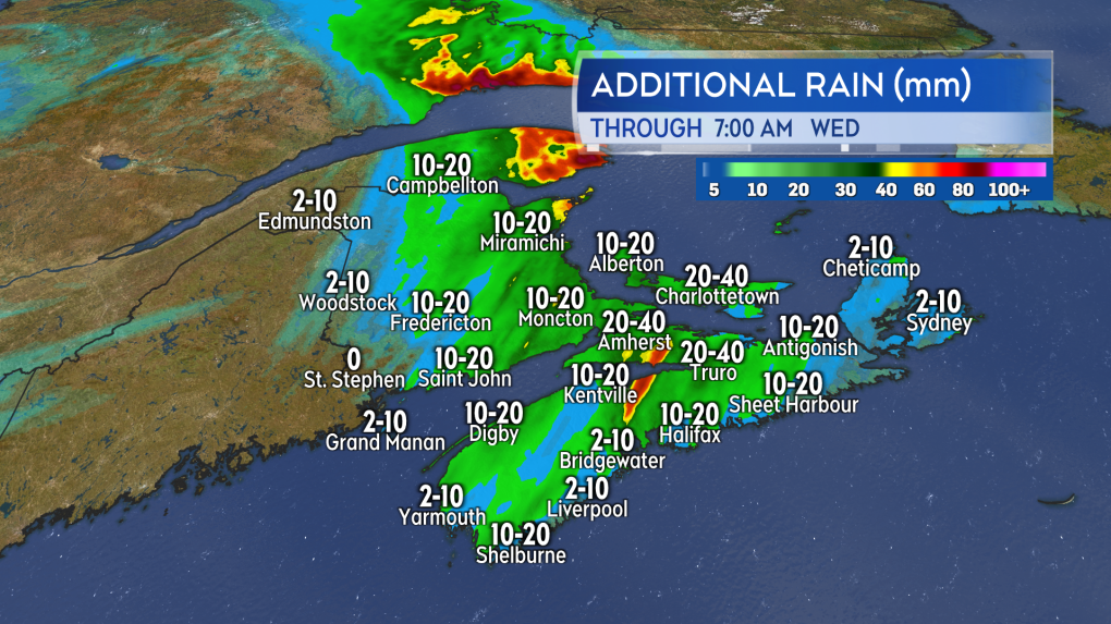 An additional five to 15 mm of rain expected for much of the Maritimes. Downpours could produce local totals of 15 to 40 mm. (Source: CTV News Atlantic)
Frost advisory issued
A cooler brand of autumn air moves in behind the front. Frost advisories are in effect for much of New Brunswick as temperatures are expected to fall into a range -3 C to +4 C by early Wednesday morning. The chilliest of those temperatures is expected in low-lying areas in the northwest of the province.
High temperatures in the Maritimes are expected to be held in the low-teens through the end of this week, which is near to just below seasonable for this time of the year.
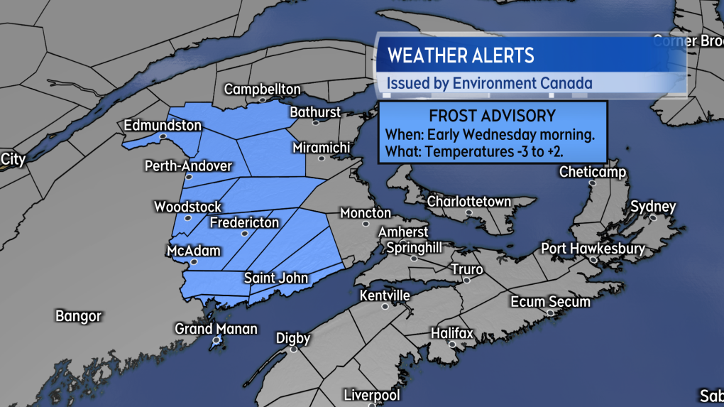 Cooler air follows the wet weather. Chilly enough tonight in New Brunswick to get some patchy frost to develop. (Source: CTV News Atlantic)
Hurricane Milton update
Hurricane Milton fluctuated between a category-five and category-four hurricane Monday into Tuesday. The storm is expected to become a strong category-three hurricane before making landfall in western Florida Wednesday night. The storm will maintain as a hurricane as it crosses Florida and exits east over the Atlantic Ocean.
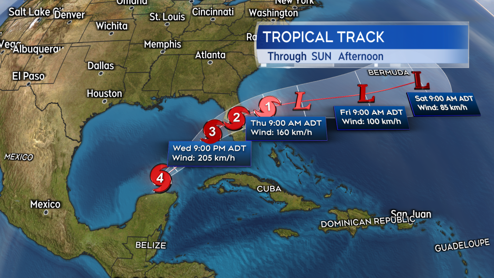 The cone forecast for Hurricane Milton. Expected to landfall in Florida as a strong category-three hurricane. (Source: CTV News Atlantic)
The landfall point in Florida looks increasingly likely to be near Tampa. Areas just to the south of Tampa have the highest chance of experiencing the strongest of the hurricane force winds. A larger area of Florida will experience tropical storm to near hurricane force winds. The wind will heavily damage utility infrastructure and down trees.
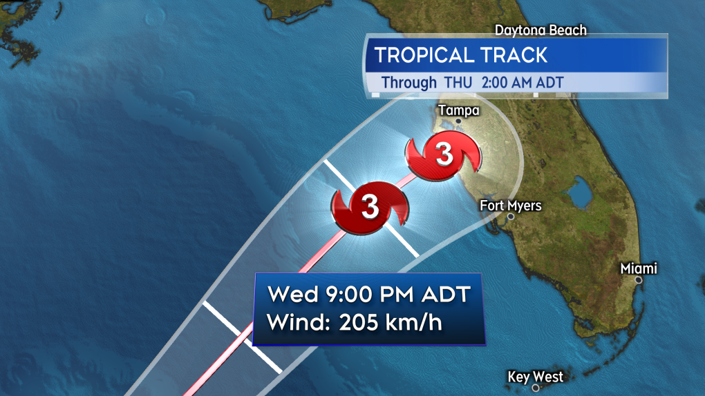 The landfall point looking increasingly likely near or just south of Tampa. (Source: CTV News Atlantic)
Water hazards are going to be the most dangerous part of the storm. Storm surge could crest as high 2.7-to-4.5 metres (eight-to-15 feet) above typical high tide marks on parts of the coastline from Tampa to Fort Myers. Inland rain could total as much as 200-to-450 millimetres for an area beginning near Tampa and extending into northern areas of Florida, including Gainesville and just south of Jacksonville. The torrential rain will create extensive flash and urban flooding.
There remain no indications of any movement northward of the storm towards the Maritimes or Atlantic Canada, even in extended forecast models.
CTVNews.ca Top Stories

opinion Tom Mulcair: Prime Minister Justin Trudeau's train wreck of a final act
In his latest column for CTVNews.ca, former NDP leader and political analyst Tom Mulcair puts a spotlight on the 'spectacular failure' of Prime Minister Justin Trudeau's final act on the political stage.
B.C. mayor gets calls from across Canada about 'crazy' plan to recruit doctors
A British Columbia community's "out-of-the-box" plan to ease its family doctor shortage by hiring physicians as city employees is sparking interest from across Canada, says Colwood Mayor Doug Kobayashi.
'There’s no support': Domestic abuse survivor shares difficulties leaving her relationship
An Edmonton woman who tried to flee an abusive relationship ended up back where she started in part due to a lack of shelter space.
Baseball Hall of Famer Rickey Henderson dead at 65, reports say
Rickey Henderson, a Baseball Hall of Famer and Major League Baseball’s all-time stolen bases leader, is dead at 65, according to multiple reports.
Arizona third-grader saves choking friend
An Arizona third-grader is being recognized by his local fire department after saving a friend from choking.
Germans mourn the 5 killed and 200 injured in the apparent attack on a Christmas market
Germans on Saturday mourned the victims of an apparent attack in which authorities say a doctor drove into a busy outdoor Christmas market, killing five people, injuring 200 others and shaking the public’s sense of security at what would otherwise be a time of joy.
Blake Lively accuses 'It Ends With Us' director Justin Baldoni of harassment and smear campaign
Blake Lively has accused her 'It Ends With Us' director and co-star Justin Baldoni of sexual harassment on the set of the movie and a subsequent effort to “destroy' her reputation in a legal complaint.
Oysters distributed in B.C., Alberta, Ontario recalled for norovirus contamination
The Canadian Food Inspection Agency has issued a recall due to possible norovirus contamination of certain oysters distributed in British Columbia, Alberta and Ontario.
New rules clarify when travellers are compensated for flight disruptions
The federal government is proposing new rules surrounding airlines' obligations to travellers whose flights are disrupted, even when delays or cancellations are caused by an "exceptional circumstance" outside of carriers' control.


