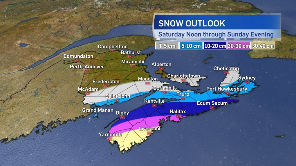
A swipe of heavy snow is expected for parts of Nova Scotia beginning Saturday afternoon and evening and running into Sunday.
The low pressure system in question swings up from the Carolinas to just south of Nova Scotia by Saturday evening. From there, the storm will move northeast and offshore of the Atlantic coastline of the province.
Snow starts in Digby, Yarmouth, and Shelburne counties of Nova Scotia near noon Saturday. In the afternoon and evening, the snow spreads northeast across much of the mainland and into southern areas of New Brunswick. By late Saturday night, the snow reaches Cape Breton and P.E.I. The heaviest of the snow is forecast for western Nova Scotia, particularly for communities near, or on, the Atlantic coastline. For those areas, snowfall amounts in excess of 15 cm are forecast with the highest amounts for Yarmouth, Shelburne, and Queens Counties where local amounts may come up to near 30 or 40 cm. The snow will be accompanied by east and northeast winds turning north with gusts of 40 to 60 km/h. Visibility will be reduced in falling and blowing snow.
A series of snowfall and winter storm warnings have been issued for areas of Nova Scotia. A special weather statement remains in place for New Brunswick and P.E.I. cautioning that, while lighter, some accumulating snow is forecast for late Saturday into Sunday.
The snowy weather clears the southwest of the region by Sunday morning and eastern areas, including Cape Breton, by Sunday afternoon. There remains a degree of uncertainty in the exact path the storm will take past the Maritimes and should that shift east or west the heaviest snow will shift with it.
Maritimers won’t want to let their guard down following the clearing of this snow. A second low pressure system is still forecast to move in on Monday with more widespread impacts from snow, ice, rain, and wind around the region.


