Coastal storm may bring heavy snow to Nova Scotia Tuesday and Wednesday
A low pressure system out of Texas will rapidly intensify into a coastal storm near New England by Tuesday morning.
The storm will then track south and east of Nova Scotia but will likely come close enough to bring heavy snowfall and high wind to parts of that province.
Timing
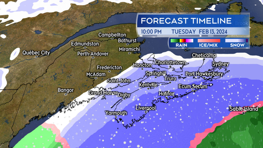
Monday night through Tuesday morning will be generally fair. Snow and blowing snow will develop in southwestern Nova Scotia Tuesday afternoon. Weather conditions across much of Nova Scotia will deteriorate by and through Tuesday evening. Eastern Prince Edward Island could also get into snow and blowing snow Tuesday night and Wednesday. Only a lighter snow or flurries are expected for southern areas of New Brunswick at this time.
Western Nova Scotia is expected to be through the snow by Wednesday morning. Pictou, Antigonish, Guysborough, and Cape Breton, along with Queens and Kings counties in Prince Edward Island, may have to contend with further snow squalls through Wednesday night. Those additional snow squalls are expected to ease and diminish by Thursday morning.
 Snow and blowing snow develops west to east across Nova Scotia Tuesday afternoon through evening. (Source: CTV News Atlantic)
Snow amounts
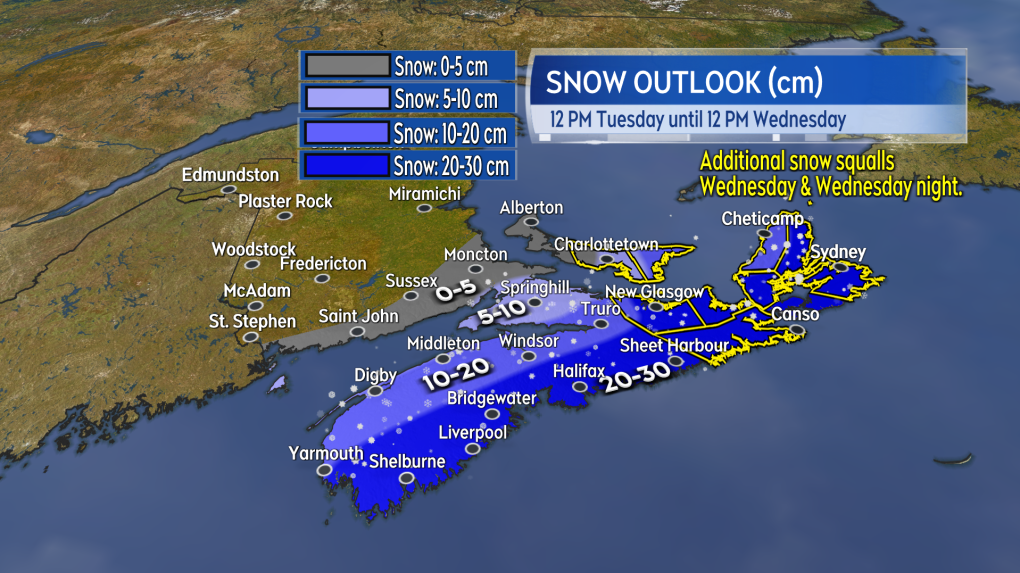
A large area of Nova Scotia could see snow totals of 10-to-30 cm. The highest snow totals are more likely in two areas. The first are the Atlantic coastal counties of Nova Scotia being closest to the passing storm. The second is Pictou/Antigonish/Inverness counties, as well as Kings County, P.E.I. For those areas there is a risk additional snow squalls off the Gulf of St. Lawrence could bring in localized snow amounts of 10-to-20 cm Wednesday afternoon through Thursday morning. You will likely need to check for cancellations and delays related to the snow for Wednesday if you are in an area where it is heavier.
Snow is expected to be much lighter for western Prince Edward Island and southern New Brunswick. Central and northern areas of New Brunswick are not expected to receive snow from the storm.
Winter Storm Watches and Winter Storm Warnings have been posted by Environment Canada for the province of Nova Scotia.
 Possible snow Tuesday noon through Wednesday noon. (Source: CTV News Atlantic)
Wind
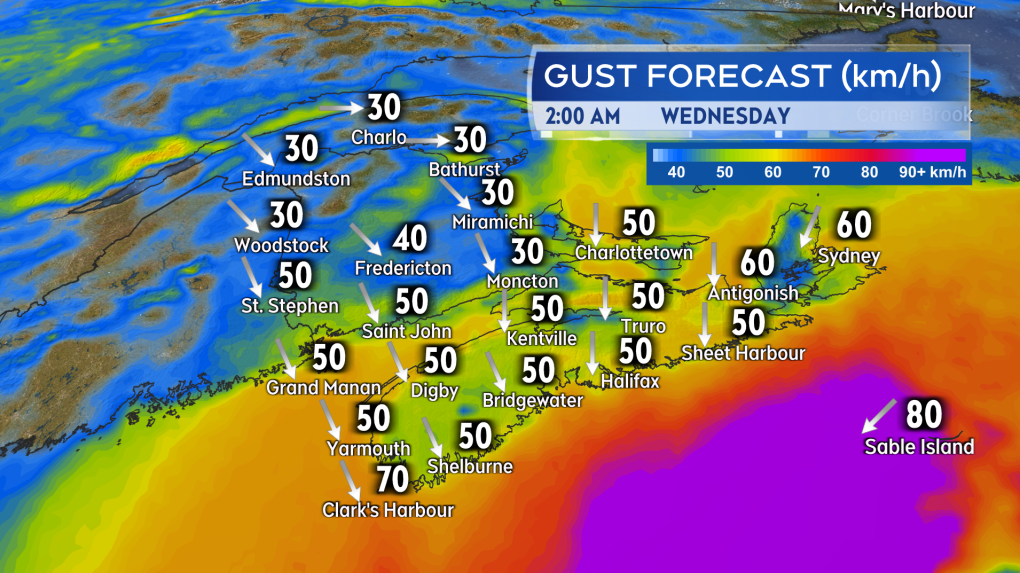
A high northerly wind will accompany the snow Tuesday into the night. Peak gusts ranging 40-to-70 km/h for Nova Scotia and Prince Edward Island except up to 80 km/h on exposed areas of the Atlantic coastline of Nova Scotia. The wind could create blowing and drifting snow.
The wind will become northwest by Wednesday afternoon. Sustained 20-to-40 km/h with gusts of 40-to-60 km/h for the region. The gusty northwest wind will persist into Thursday. A lighter wind is expected Friday.
 A high and gusty northerly wind will accompany the snow Tuesday evening and night for Nova Scotia and Prince Edward Island. (Source: CTV News Atlantic)
Watch the forecast
It is highly recommended that you continue to check in on your forecast Tuesday and Wednesday, especially if you are in or travelling through Prince Edward Island or Nova Scotia during that time. There has been an extreme amount of variance in weather models for this storm. Some continue to bring heavier snowfall amounts near 30 cm further into Nova Scotia while others hold the heaviest snow just offshore of that province. It is not just our region that is contending with that uncertainty at the moment as they are struggling with it in eastern U.S. as well where the storm will arrive before coming to us.
I’ll have updates, timelines, and region weather conditions on CTV News Atlantic programming at 5, 6, and 11:30 p.m.
For more Nova Scotia news visit our dedicated provincial page.
CTVNews.ca Top Stories

Trudeau's 2024: Did the PM become less popular this year?
Justin Trudeau’s numbers have been relatively steady this calendar year, but they've also been at their worst, according to tracking data from CTV News pollster Nik Nanos.
Back on air: John Vennavally-Rao on reclaiming his career while living with cancer
'In February, there was a time when I thought my career as a TV reporter was over,' CTV News reporter and anchor John Vennavally-Rao writes.
The winter solstice is here, the Northern Hemisphere's darkest day
The winter solstice is Saturday, bringing the shortest day and longest night of the year to the Northern Hemisphere — ideal conditions for holiday lights and warm blankets.
What we know about the suspect behind the German Christmas market attack
Germany on Saturday was still in shock and struggling to understand the suspect behind the attack in the city of Magdeburg.
Poilievre writes to GG calling for House recall, confidence vote after Singh declares he's ready to bring Liberals down
Conservative Leader Pierre Poilievre has written to Gov. Gen. Mary Simon, imploring her to 'use your authority to inform the prime minister that he must' recall the House of Commons so a non-confidence vote can be held. This move comes in light of NDP Leader Jagmeet Singh publishing a letter stating his caucus 'will vote to bring this government down' sometime in 2025.
Overheated immigration system needed 'discipline' infusion: minister
An 'overheated' immigration system that admitted record numbers of newcomers to the country has harmed Canada's decades-old consensus on the benefits of immigration, Immigration Minister Marc Miller said, as he reflected on the changes in his department in a year-end interview.
School custodian stages surprise for Kitchener, Ont. students ahead of holiday break
He’s no Elf on the Shelf, but maybe closer to Ward of the Board.
Kelly Clarkson's subtle yet satisfying message to anyone single this Christmas
The singer and daytime-talk show host released a fireside video to accompany her 2021 holiday album, “When Christmas Comes Around” that she dubbed, “When Christmas Comes Around…Again.
Judge sentences Quebecer convicted of triple murder who shows 'no remorse'
A Quebecer convicted in a triple murder on Montreal's South Shore has been sentenced to life in prison without chance of parole for 20 years in the second-degree death of Synthia Bussieres.


