Rain and freezing rain linger into Tuesday for parts of Maritimes
A stagnant weather pattern has resulted in a series of low-pressure systems in the Maritimes bringing several rounds of rain and icy weather going back to Friday.
STORM REPORTS
Total precipitation amounts, including snow, freezing rain, and rain, have reached and exceeded 60, 80, and even 100 mm for large parts of the region, with more to come into Tuesday.
In a lot of cases, that’s about half or more of the monthly average for January in just a few days. However, the total precipitation doesn’t tell the whole story.
For instance, in northern areas of New Brunswick most of that came in the form of snow on Friday with snow totals ranging 40 to 55 cm for some communities.
An extended period of freezing rain was present for Nova Scotia, Prince Edward Island, and parts of southern New Brunswick Sunday into Monday. The ice accretion leading to sagging and breaking trees and branches, slick surfaces, and power outages.
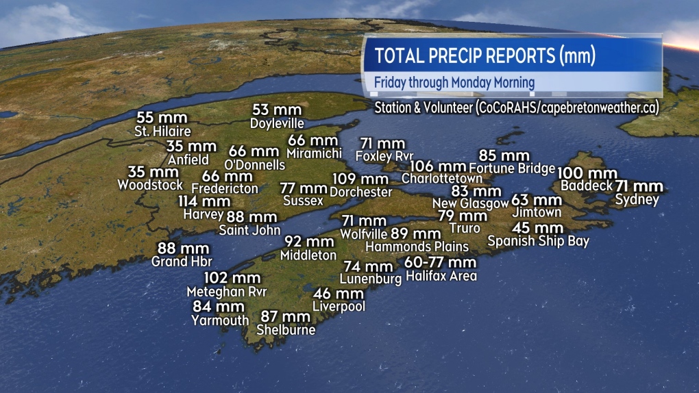 Total precipitation reports, including snow and rain, for the Maritimes Friday into Monday morning.
MORE TO COME
Further periods of rain is expected for Nova Scotia and P.E.I. Monday into Tuesday, though the rain will become much lighter. The remaining mix of ice pellets and freezing rain in New Brunswick will turn to lighter rain and drizzle for most of the province Monday night as temperatures rise above the freezing mark.
The northwestern corner of New Brunswick is likely to remain in a light, icy mix of weather on Tuesday. Both rainfall and freezing rain warnings persist for a large portion of the Maritimes.
The good news is that the remaining precipitation is much lighter on Tuesday. By Wednesday, the region is down to a chance of some scattered flurries and showers.
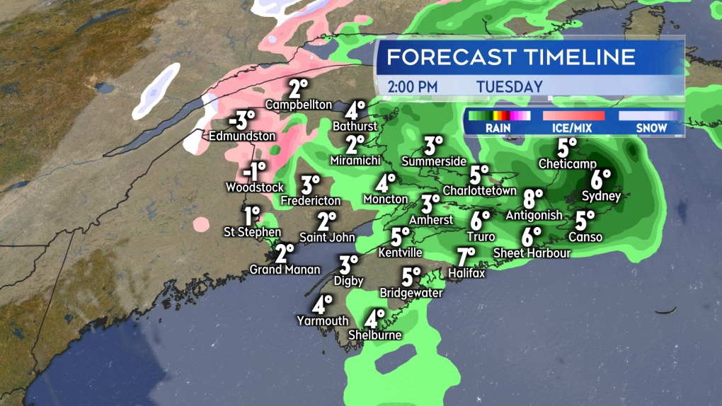 Southern and eastern areas of New Brunswick should switch from freezing rain to rain Monday night. Freezing rain may still be present in the northwest of the province on Tuesday.
WATCHING FRIDAY
Even as the Maritimes clears the current series of lows, another system needs to be watched for Friday.
It’s a Colorado Low that is expected to move through the northeastern U.S. and then pass between Nova Scotia and Sable Island. That track would keep the Maritimes in colder air, resulting in more of a snow producer than the rainy/icy mix of the past couple days.
Looks like a possible 5 to 15 cm event for Nova Scotia, with a lighter snow for P.E.I. and New Brunswick. A change in track or intensification of that system in the forecast could up the expected amount of snow.
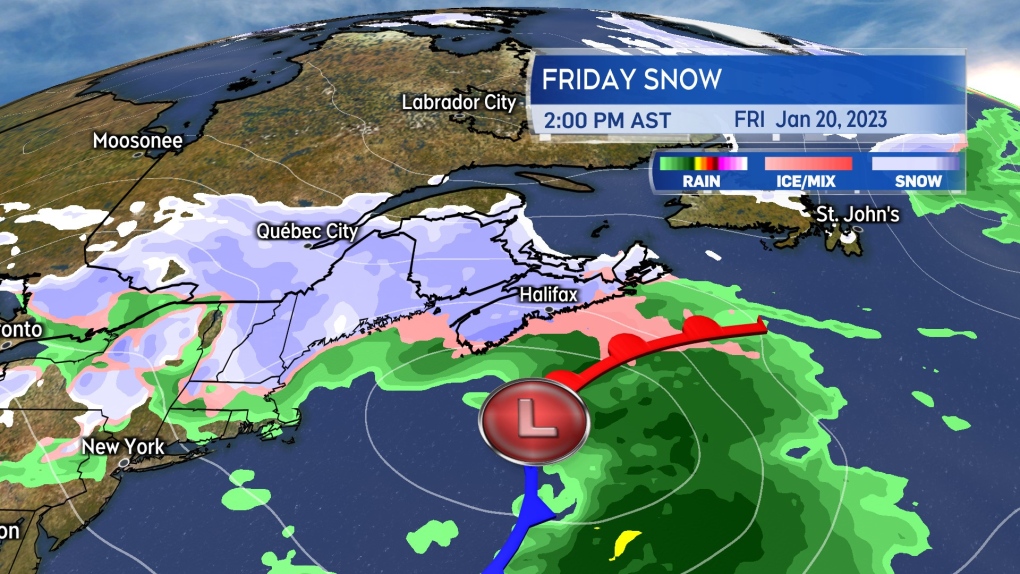 While still more than a few days out, a passing low could bring a round of snow to the Maritimes on Friday.
CTVNews.ca Top Stories

Quebec nurse had to clean up after husband's death in Montreal hospital
On a night she should have been mourning, a nurse from Quebec's Laurentians region says she was forced to clean up her husband after he died at a hospital in Montreal.
Northern Ont. lawyer who abandoned clients in child protection cases disbarred
A North Bay, Ont., lawyer who abandoned 15 clients – many of them child protection cases – has lost his licence to practise law.
Bank of Canada officials split on when to start cutting interest rates
Members of the Bank of Canada's governing council were split on how long the central bank should wait before it starts cutting interest rates when they met earlier this month.
Maple Leafs fall to Bruins in Game 3, trail series 2-1
Brad Marchand scored twice, including the winner in the third period, and added an assist as the Boston Bruins downed the Toronto Maple Leafs 4-2 to take a 2-1 lead in their first-round playoff series Wednesday
Cuban government apologizes to Montreal-area family after delivering wrong body
Cuba's foreign affairs minister has apologized to a Montreal-area family after they were sent the wrong body following the death of a loved one.
'It was instant karma': Viral video captures failed theft attempt in Nanaimo, B.C.
Mounties in Nanaimo, B.C., say two late-night revellers are lucky their allegedly drunken antics weren't reported to police after security cameras captured the men trying to steal a heavy sign from a downtown business.
What is changing about Canada's capital gains tax and how does it impact me?
The federal government's proposed change to capital gains taxation is expected to increase taxes on investments and mainly affect wealthy Canadians and businesses. Here's what you need to know about the move.
New Indigenous loan guarantee program a 'really big deal,' Freeland says at Toronto conference
Canada's Deputy Prime Minister Chrystia Freeland was among the 1,700 delegates attending the two-day First Nations Major Projects Coalition (FNMPC) conference that concluded Tuesday in Toronto.
'Life was not fair to him': Daughter of N.B. man exonerated of murder remembers him as a kind soul
The daughter of a New Brunswick man recently exonerated from murder, is remembering her father as somebody who, despite a wrongful conviction, never became bitter or angry.


