Rain in Nova Scotia ranks among historical events
With a large swath of rain totaling more than 200 millimetres -- much of it falling in less than 12 hours -- this weather event will rank among the worst historical floods for Nova Scotia.
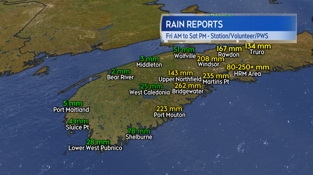 Preliminary rainfall reports in the western half of the province.
The very heaviest of the rain started on the South Shore of Nova Scotia and then continued up into Halifax Regional Municipality and Hants County. Dozens of personal weather stations operating in the province totalled rain in excess of 200 millimetres. A radar estimate by Environment Canada indicates that some rain totals in the vicinity of Panuke Lake may have exceeded 300 millimetres.
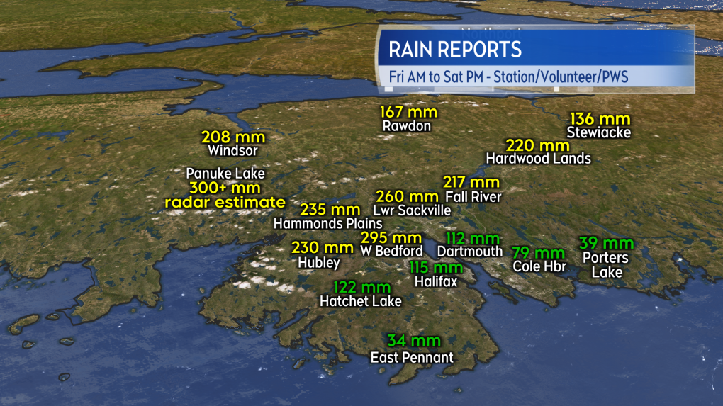 Some of the suburban areas of the Halifax Regional Municipality were hit particularly hard by dozens of rounds of downpours and thunderstorms.
It wasn’t just the total amounts of rain that created catastrophic flooding but the rate at which it arrived as well. Rain totals were estimated to be upwards of 30 millimetres per hour and that was confirmed by Environment Canada-operated weather stations at Debert and Bedford Range, which both pick up one hour rain amounts nearing 40 millimetres.
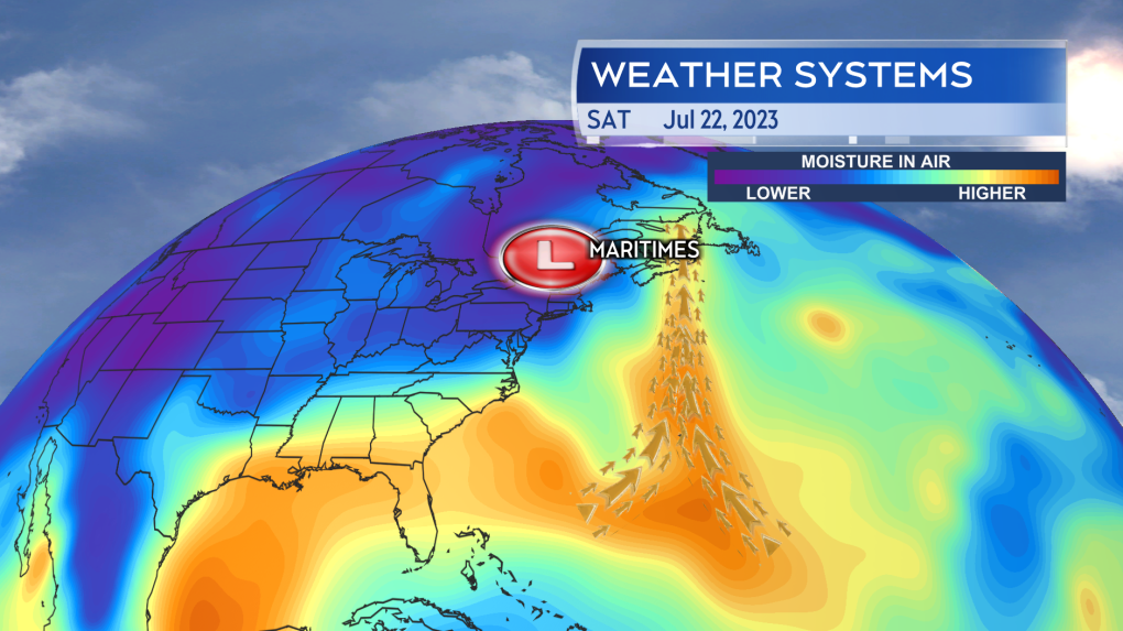 A slow-moving low-pressure system acted to reinforce tropical air moving up from the south, providing a feed of moisture into the downpours and thunderstorms.
The totals are comparable to events such as the November 2021 floods in Cape Breton, the Thanksgiving Day flood of October 2016 in Cape Breton, and Hurricane Beth in 1971. Compared to those events though, these totals appear to have arrived in an even shorter duration. For example, the 266 millimetres of rain reported by Halifax International Airport due to Hurricane Beth is over 30 hours as opposed to 12 hours or less.
Daily and possibly monthly rain records are likely to have been set for some areas. CTV News contacted Environment Canada for more on historical records. They are in the process of gathering data on the event and will release further information on records when done.
 Moving into Saturday evening, the most remaining downpours are centred on the Eastern Shore of Nova Scotia and Cape Breton. Rain totals continue to add up and the downpours are forecast to ease to showers Saturday night into Sunday morning.
Periodic rain and downpours continues for parts of eastern Nova Scotia moving into Saturday evening. It looks unlikely that the eastern parts of the province will match the extremes seen in locations further to the west. That said, a number of weather stations are reporting totals in a range of 50 to just over 100 millimetres. Flooding and flash flooding remains a risk. The last area of the province to get out of the periods of heavier rain will be Cape Breton.
Cape Breton is expected to see the downpours east to showers Saturday night into early Sunday morning.
For more Nova Scotia news visit our dedicated provincial page.
Shopping Trends
The Shopping Trends team is independent of the journalists at CTV News. We may earn a commission when you use our links to shop. Read about us.


CTVNews.ca Top Stories

Poilievre writes to GG calling for House recall, confidence vote after Singh declares he's ready to bring Liberals down
Conservative Leader Pierre Poilievre has written to Gov. Gen. Mary Simon, imploring her to 'use your authority to inform the prime minister that he must' recall the House of Commons so a non-confidence vote can be held. This move comes in light of NDP Leader Jagmeet Singh publishing a letter stating his caucus 'will vote to bring this government down' sometime in 2025.
BREAKING
BREAKING At least 2 dead and 60 hurt after a car drives into a German Christmas market in a suspected attack
A car plowed into a busy outdoor Christmas market in the eastern German city of Magdeburg on Friday, killing at least two people and injuring at least 60 others in what authorities suspect was an attack.
Judge sentences Quebecer convicted of triple murder who shows 'no remorse'
A Quebecer convicted in a triple murder on Montreal's South Shore has been sentenced to life in prison without chance of parole for 20 years in the second-degree death of Synthia Bussieres.
'I understand there's going to be a short runway,' new minister says after Trudeau shuffles cabinet
Prime Minister Justin Trudeau added eight Liberal MPs to his front bench and reassigned four ministers in a cabinet shuffle in Ottawa on Friday, but as soon as they were sworn-in, they faced questions about the political future of their government, and their leader.
BREAKING
BREAKING Fake nurse Brigitte Cleroux sentenced to 7 years in prison
A woman who illegally treated nearly 1,000 patients in British Columbia while impersonating a nurse has been sentenced to seven years in prison.
Poilievre to Trump: 'Canada will never be the 51st state'
Conservative leader Pierre Poilievre is responding to U.S. president-elect Donald Trump’s ongoing suggestions that Canada become the 51st state, saying it will 'never happen.'
Toronto officials warn of possible measles exposure at Pearson airport
Toronto Public Health (TPH) is advising of another possible measles exposure at Canada’s largest airport.
Bail denied for Winnipeg woman accused of killing animals in online videos
Warning: This story contains disturbing details. Discretion is advised. A Winnipeg woman accused of making videos of animals being tortured and killed that were sold on the dark web was denied bail.
Party City closing in U.S., Canadian stores remain 'open for business'
The impending closure of all Party City locations in the United States will not extend into Canada.
Toronto
-

'Enough is enough': Toronto Jewish school struck by gunfire for third time since May
A Jewish elementary school in Toronto has been struck by gunfire for the third time in the last seven months.
-
6 arrested, 5 remain at large in auto theft ring that operated around Toronto Pearson Airport: police
Peel police have arrested seven people and issued arrest warrants for five more suspects who are allegedly part of a Quebec theft ring responsible for stealing more than 100 vehicles in and around Toronto Pearson International Airport.
-
Police say break-and-enter suspects were in Canada for 'purpose of committing criminal offences'
Five Chilean nationals who police believe were in Canada for 'the purpose of committing criminal offences' have been charged in connection with half a dozen break-and-enters across the Greater Toronto Area (GTA).
Calgary
-

3 people sent to hospital after serious crash on Deerfoot Trail
A serious crash closed part of Deerfoot Trail on Friday afternoon.
-
Calgary man arrested in connection with more than a dozen robberies
Police say charges have been laid against a 19-year-old man in connection with a series of robberies that targeted cannabis and convenience stores in Calgary and Edmonton.
-
Alberta announces plan to develop 'modernized' coal policy
The future of coal mining in Alberta will be governed by a new, modern approach, the province announced on Friday.
Edmonton
-
Poilievre writes to GG calling for House recall, confidence vote after Singh declares he's ready to bring Liberals down
Conservative Leader Pierre Poilievre has written to Gov. Gen. Mary Simon, imploring her to 'use your authority to inform the prime minister that he must' recall the House of Commons so a non-confidence vote can be held. This move comes in light of NDP Leader Jagmeet Singh publishing a letter stating his caucus 'will vote to bring this government down' sometime in 2025.
-
Witnesses wanted after RCMP shoot 2 men in December: police watchdog
Alberta's police watchdog is looking for witnesses in two police shootings that killed one man and left another in critical condition.
-
20 years of providing Edmontonians in need with holiday hampers
Saturday is a big day for an Edmonton charity and it's also the 20th year the organization has handed out its namesake holiday hampers to those in need.
Montreal
-

Judge sentences Quebecer convicted of triple murder who shows 'no remorse'
A Quebecer convicted in a triple murder on Montreal's South Shore has been sentenced to life in prison without chance of parole for 20 years in the second-degree death of Synthia Bussieres.
-
Police search for suspect in connection with woman's abduction, attempted homicide
A woman in her 20s who was possibly abducted by her ex is in hospital after the car she was in plunged into the Richelieu River.
-
Cold snap brings hope of a white Christmas in Montreal
A cold Christmas awaits Montrealers this year with varying mixes of sun and clouds.
Ottawa
-

Restaurants still waiting to see if GST/HST holiday impacts business
Reviews are beginning to come in from customers and restaurants a few days into the federal government's GST/HST holiday.
-
Man allegedly filming females in public washroom in business on Elgin Street, police looking for more victims
The Ottawa Police Service says a man has been arrested following a report alleging he was filming women inside a public washroom in a business on Elgin Street last weekend.
-
‘Hot and frosty’: Film industry booming in Ottawa
Ottawa is not only a hot spot for tourism, but also a landmark when it comes to the film industry and holiday movies, says the City of Ottawa.
London
-

Man dies after falling from building: LPS
London police say a man has died after falling from a building.
-
Fire destroys London Cricket Club memorabilia, equipment
A fire destroyed thousands of dollars worth of property and memorabilia at the London Cricket Club.
-
Manslaughter charge laid against London man after August drug bust
A London man has been charged with manslaughter after an OPP drug raid this summer. Police have released few details but say they used a search warrant at a West Elgin home Aug. 23.
Barrie
-

Multi-vehicle collision on Highway 11 in Oro-Medonte
Southbound traffic along Highway 11 through Oro-Medonte was brought to a crawl Friday after a multi-vehicle collision.
-
High school teacher charged with sexual assault amid allegations involving a student
A 51-year-old teacher from Georgina has been charged with sexual assault following allegations involving a student.
-
Driver charged after vehicle crashes into Barrie home
A driver was arrested Thursday night after a vehicle crashed into a home in Barrie.
Northern Ontario
-
Poilievre writes to GG calling for House recall, confidence vote after Singh declares he's ready to bring Liberals down
Conservative Leader Pierre Poilievre has written to Gov. Gen. Mary Simon, imploring her to 'use your authority to inform the prime minister that he must' recall the House of Commons so a non-confidence vote can be held. This move comes in light of NDP Leader Jagmeet Singh publishing a letter stating his caucus 'will vote to bring this government down' sometime in 2025.
-
Northern Ont. man illegally killed three moose, one deer
A man from the northwestern Ontario community of Dinorwic has been found guilty of multiple hunting offences and fined $6,500, banned from hunting for five years and placed on probation for 18 months.
-
North Bay-area man wanted on 19 charges, including spousal assault, drug trafficking
Police are asking for the public's help in finding a suspect wanted for a host of offences, ranging from assault to uttering death threats.
Kitchener
-

Guelph man pleads guilty to fleeing fatal crash involving cyclist
A Guelph driver, who previously admitted to failing to stop after a fatal crash, instead plead guilty to a different charge on Friday.
-
Police believe shots fired into Cambridge home was a targeted incident
Waterloo Regional Police Service now believes shot fired into a Cambridge home was a targeted incident.
-
Homeowners in Waterloo Region to pay 9.48 per cent more on region's 2025 property tax bill
After councillors failed to set Waterloo Region’s 2025 budget in a marathon meeting earlier this month, councillors gathered again on Thursday to try to hammer down what was once a 10.45 per cent property tax hike.
Windsor
-

Clear Medical Imaging strike ends with arbitration agreement
The eight-week long strike action at Clear Medical Imaging has ended. According to officials, Unifor and the employer have agreed to binding arbitration.
-
Over $45,000 in cash and drugs seized: WPS
Two suspects have been arrested and over $45,000 in cash and drugs seized following an investigation by the Windsor Police Service (WPS).
-
Toll increase coming to the Windsor-Detroit Tunnel in 2025
Drivers heading through the Windsor-Detroit Tunnel in the new year will have to take some extra cash. A toll increase for those heading from Canada to the U.S. is scheduled for Jan. 1, 2025 .
Winnipeg
-

Bail denied for Winnipeg woman accused of killing animals in online videos
Warning: This story contains disturbing details. Discretion is advised. A Winnipeg woman accused of making videos of animals being tortured and killed that were sold on the dark web was denied bail.
-
Avian influenza found at Manitoba farm
The Canadian Food Inspection Agency (CFIA) has found a strain of avian flu at a Manitoba poultry farm.
-
Ontario town seeks judicial review after being fined $15K for refusing to observe Pride Month
An Ontario community fined $15,000 for not celebrating Pride Month is asking a judge to review the decision.
Regina
-

Highway closures in place as winter driving conditions return
After receiving another big dump of snow over the past couple of days, Saskatchewan drivers have had to contend with some treacherous driving conditions.
-
Local groups work to give people extra support this holiday season
As the holidays approach, outreach groups are working to give people in the community a bit of extra support.
-
Appeal dismissed in Sask. 'thumbs up' emoji case
An appeal to a legal case that made international headlines has been dismissed by Saskatchewan's highest court.
Saskatoon
-

Saskatoon police release details about latest homicide
Saskatoon police are releasing new details about the city’s latest homicide, although no charges have yet been laid.
-
Search continues for man wanted in connection with all-day manhunt in northern Sask.
The Saskatchewan RCMP are still searching for 28-year-old Dallas Fulton, wanted in connection with a dangerous person alert sent out across the province in October.
-
Saskatchewan highway closed due to serious collision
The Saskatoon RCMP are currently responding to a serious collision on Highway 5, west of Meacham.
Vancouver
-

BCLC warns parents against the dangers of child gambling at Christmas
Scratch cards in stockings might seem like an exciting Christmas idea, but for those who are under the legal age limit, being lured into gambling too early could cause more mess than merriment further down the line, says the British Columbia Lottery Corporation.
-
City confirms Stanley Park Train cancelled for the holiday season
Rides on Stanley Park’s iconic Christmas train will be shelved for another year for thousands of ticket holders, as officials confirm the train’s closure will continue for the remainder of the holiday season.
-
YVR gears up for the busiest travel day of the holiday season
The holiday travel season is ramping up this weekend as many people head out of town to see friends and family.
Vancouver Island
-

Victoria police make 42 arrests in retail theft crackdown
Police in Victoria say officers have made 42 arrests and recovered approximately $10,000 in stolen merchandise during a four-day retail theft operation targeting repeat offenders.
-
Loans, delays, legal action: B.C. renovator blames illness for project stalls, denies faking cancer
Two Metro Vancouver homeowners have come forward with new allegations against a local renovator accused of faking cancer to avoid repaying a debt, saying they are also owed money after handing over hefty sums for projects that have not been completed.
-
BC Civil Liberties Association calls for review of MAID legislation
The British Columbia Civil Liberties Association is calling on the provincial and federal governments to review medically-assisted dying legislation to ensure proper safeguards are in place.
Kelowna
-

Forfeited Hells Angels clubhouse in Kelowna, B.C., sold to the city
A former Hells Angels clubhouse that was seized by the British Columbia government in 2023 after years of fighting in court has been sold to the City of Kelowna.
-
Death of woman found in Kelowna's Waterfront Park in June deemed 'non-criminal in nature': RCMP
Police in Kelowna say a death they began investigating back in June has now been confirmed as "non-criminal in nature."
-
B.C. man sentenced for 'execution-style' murder of bystander in drug trade conflict
A B.C. man convicted of the "intentional and ruthless killing of a bystander" while acting as an enforcer in the drug trade has been sentenced for a second time in the slaying.


