Rainfall and wind warnings issued in the Maritimes ahead of Philippe
Special weather statements have been upgraded to warnings for parts of the Maritimes ahead of the arrival of post-tropical storm Philippe.
WARNINGS
Rainfall Warnings have been issued for much of western New Brunswick where 40 to 60 mm or more of rain is expected. Most of the rain is expected to fall Saturday night and Sunday morning.
A Special Weather Statement remains in effect for eastern New Brunswick as peak wind gusts will reach 80 km/h over exposed areas.
In Nova Scotia, a rainfall warning is in place for Digby, Yarmouth, Shelburne, Queens, and Lunenburg Counties.
Rain beginning Saturday evening and ending Sunday morning could total 40 to 60 mm, with locally higher amounts possible.
Atlantic coastal counties, including Halifax and Guysborough, are under a wind warning.
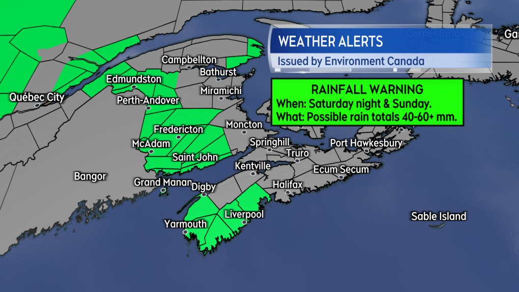 Some of the stronger wind gusts are expected on and near the Atlantic coastline of Nova Scotia. (CTV/Kalin Mitchell)
Easterly winds will reach maximum gusts near 90 km/h late Saturday evening through Sunday morning. Northern Inverness County in Cape Breton is also under a wind warning as Sunday southeast gusts could reach 120 km/h due to the topography of the Highlands.
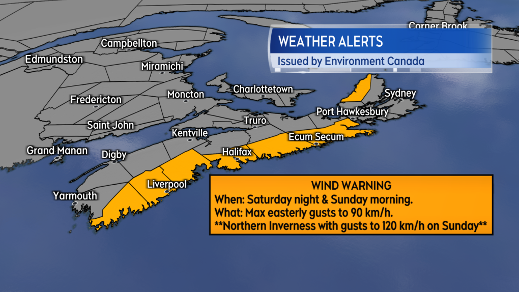 Some of the stronger wind gusts are expected on and near the Atlantic coastline of Nova Scotia. (CTV/Kalin Mitchell)
A special weather statement remains in effect for the remainder of Nova Scotia. The statement cautions potential wind gusts up to 80 km/h. The agency noted “similar winds in the past have caused some tree damage and scattered utility outages.”
Special weather statements continue for Prince Edward Island and the Magdalen Islands. Wind gusts there could reach 80 km/h for Sunday morning and afternoon.
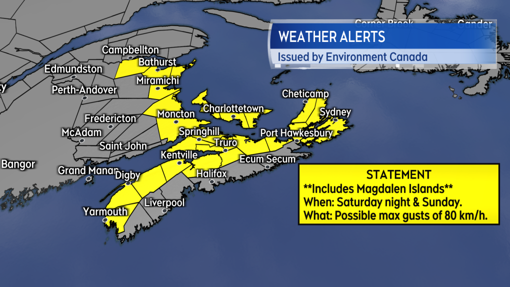 Most areas not under a warning in the Maritimes are under a Special Weather Statement.
STATUS OF PHILIPPE
Philippe was declared a post-tropical storm Friday afternoon by the National Hurricane Centre. This happened as Philippe changed structure and developed non-tropical characteristics such as weather fronts.
The storm will effect the Maritime region as something more similar to a nor’easter rather than a tropical storm or hurricane.
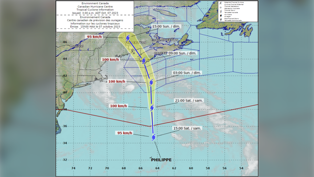 The latest track for post-tropical storm Philippe as issued by the Canadian Hurricane Centre.
Due to the transition, the National Hurricane Center has ceased issuing track updates for Philippe. The Canadian Hurricane Centre however has decided to continue to track the centre of the storm. In their latest update they have the track of the centre passing just over the southwest of Nova Scotia before moving through western New Brunswick and into the St. Lawrence River Valley.
Philippe will combine with a separate weather front as it moves along that path. The combined system will be very large, bringing rain and wind not only to Atlantic Canada but also parts of the Northeastern U.S. as well as Quebec.
While the intensity and impacts of the weather are forecast lower than post-tropical storm Lee there remains a risk of scattered power outages with the higher winds.
Wave action is also less than that brought on by Lee. The Canadian Hurricane Centre does note a risk of some wave over-wash and minor coastal flooding around 4:30 AM Sunday on the South Shore of Nova Scotia.
CTVNews.ca Top Stories

BREAKING Ontario Premier Doug Ford threatens to cut off energy to U.S. in response to Trump's tariffs
Ontario Premier Doug Ford has threatened to cut off energy supply to the U.S. in response to the tariffs President-elect Donald Trump plans to impose on all Canadian imports.
Elon Musk calls Justin Trudeau 'insufferable tool' in new social media post
Billionaire Elon Musk is calling Prime Minister Justin Trudeau 'an insufferable tool' in a new social media post on Wednesday. 'Won't be in power for much longer,' Musk also wrote about the prime minister on 'X.'
Trudeau will have to 'kiss the ring' to achieve smoother bilateral relations with Trump: John Bolton
If Prime Minister Justin Trudeau wants to get on U.S. president-elect Donald Trump's good side for the sake of a smooth bilateral relationship, he'll likely have to be openly deferential, says former U.S. National Security Advisor, John Bolton.
MAID cases rose to 15,000 in 2023, but growth of cases halved
More than 15,000 people received medical assistance in dying in Canada in 2023, but federal statistics show the growth in cases has slowed significantly.
Luxury real estate brokers charged in federal indictment with sex trafficking in NYC
Two luxury real estate brokers and their brother have been charged with luring, drugging and violently raping dozens of women over more than a decade.
Police locate labyrinth of tunnels connecting tents to generator in Hamilton encampment
Hamilton police say that they discovered a series of 'man-made holes and tunnels' during a patrol of a downtown encampment earlier this week.
Certain foods may disrupt your body's fight against cancer cells, study says
The food you eat may be affecting your body’s ability to fight cancer cells in the colon, according to a new study.
Banks lower prime rates following Bank of Canada move
Canadian financial institutions are lowering their prime lending rates to match the decrease announced by the Bank of Canada.
Toronto agency launches court challenge against new law that would shutter some supervised consumption sites
A social agency that runs a supervised consumption service (SCS) in Toronto’s Kensington Market has launched a court challenge against new legislation that will see 10 such sites shuttered across the province, arguing that the law violates the Charter of Rights and Freedoms.


