Rainfall warnings issued, freeze and icy conditions to follow
 A pedestrian shields themselves from rain as post-tropical storm Philippe causes gusting winds and precipitation in Halifax on Sunday, October 8, 2023. THE CANADIAN PRESS/Darren Calabrese
Rainfall warnings
Rainfall Warnings have been issued for Kings and Queens counties in Prince Edward Island. The warning calls for 25 to 35 mm of rain Friday evening through Saturday noon.
Much of Nova Scotia is also under a Rainfall Warning. For that province, areas under the warning can expect 25 to 50 mm of rain with high local amounts Friday evening through Saturday evening. Special Weather Statements in effect for Kings, Queens, and Shelburne counties call for slightly lower amounts of up to 25 mm of rain. No warning or statement in effect for Yarmouth, Digby, and Annapolis counties.
In the warnings and statements, Environment Canada cautions that “significant snowmelt and runoff may occur” and that “similar storms in the past have caused pooling of water on roadways and localized flooding in low lying areas.”
If you can, clearing accessible drainage from snow and ice could help with the runoff expected.
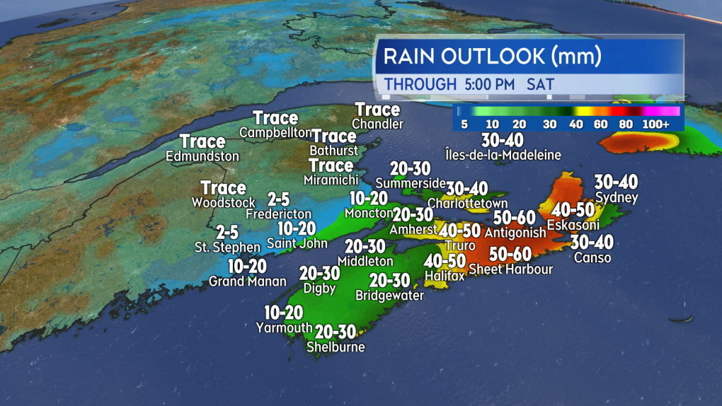 A heavy winter rain is expected for parts of Nova Scotia and Prince Edward Island. Melting snow and ice along with blocked drainage increasing the risk of localized flooding.
Rain and snow
Friday afternoon and early evening will see a light mix of snow and rain for the Maritimes. There is a risk of some patchy, light freezing rain.
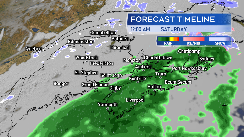 The heavier rain arrives late Friday evening into Saturday morning.
Heavier rain is expected to arrive for southern New Brunswick, Nova Scotia, and Prince Edward Island late evening and near midnight, the heavier rain continuing into Saturday morning. The rain turns to a mix of freezing rain and snow Saturday before clearing west-to-east through the day.
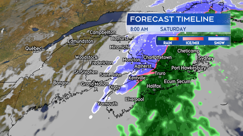 Rain clears west-to-east through Saturday. Some areas turning over to a mix of snow, ice pellets and freezing rain.
Southeastern New Brunswick, northern Nova Scotia, and Prince Edward Island look like they could get into some particularly slick conditions Saturday morning into afternoon. Indications are that area of the Maritimes could switch from the rain over to 5 to 15 cm of snow, ice pellets and freezing rain.
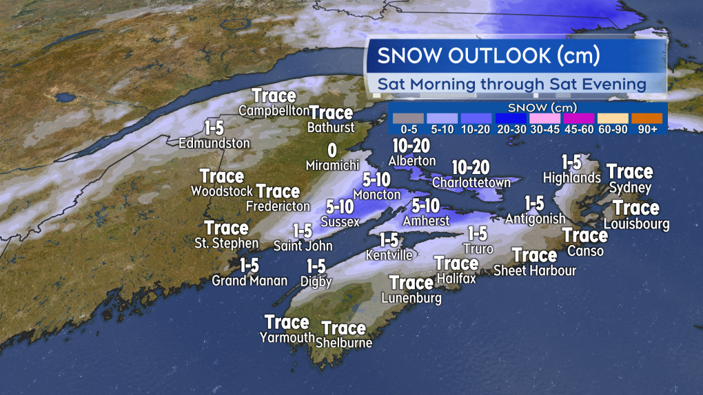 The flip back to a snowy, icy mix of precipitation could lead to some accumulations of 5 to 15 cm for parts of the Maritimes on Saturday.
Freeze and risk of ice
It won’t just be those areas that switch from rain to snow and freezing rain that will need to be cautious of icy surfaces this weekend. A cold front follows the mix of precipitation as it clears. Living up to the name, that front will put the region over into a cold, gusty northwest wind. Temperatures are expected to come down back below freezing in as little as 2 to 6 hours following the change in wind direction.
Wet or slushy surfaces could turn icy quickly. That would include roads, sidewalks, and parking lots.
New Brunswick will be below freezing by early Saturday afternoon. Prince Edward Island below freezing by late Saturday afternoon. Nova Scotia below freezing by and through Saturday evening.
I’ll have updates, timelines and regional weather conditions on CTV New Atlantic programming Friday 5 p.m., 6 p.m., and 11:30 p.m.
CTVNews.ca Top Stories

Poilievre writes to GG calling for House recall, confidence vote after Singh declares he's ready to bring Liberals down
Conservative Leader Pierre Poilievre has written to Gov. Gen. Mary Simon, imploring her to 'use your authority to inform the prime minister that he must' recall the House of Commons so a non-confidence vote can be held. This move comes in light of NDP Leader Jagmeet Singh publishing a letter stating his caucus 'will vote to bring this government down' sometime in 2025.
At least 2 dead and 60 hurt after a car drives into a German Christmas market in a suspected attack
A car plowed into a busy outdoor Christmas market in the eastern German city of Magdeburg on Friday, killing at least two people and injuring at least 60 others in what authorities suspect was an attack.
Judge sentences Quebecer convicted of triple murder who shows 'no remorse'
A Quebecer convicted in a triple murder on Montreal's South Shore has been sentenced to life in prison without chance of parole for 20 years in the second-degree death of Synthia Bussieres.
'I understand there's going to be a short runway,' new minister says after Trudeau shuffles cabinet
Prime Minister Justin Trudeau added eight Liberal MPs to his front bench and reassigned four ministers in a cabinet shuffle in Ottawa on Friday, but as soon as they were sworn-in, they faced questions about the political future of their government, and their leader.
U.S. House approves funding bill and sends to Senate hours before government shutdown deadline
Hours to go before a midnight government shutdown, the House has approved a new plan from House Speaker Mike Johnson.
Poilievre to Trump: 'Canada will never be the 51st state'
Conservative leader Pierre Poilievre is responding to U.S. president-elect Donald Trump’s ongoing suggestions that Canada become the 51st state, saying it will 'never happen.'
A new book about Chrystia Freeland just came out. Here's what we learned
A new book about Chrystia Freeland has just come out, after the publishing company sped up its release date by a few months. CTV News sifted through the book and pulled out some notable anecdotes, as well as insights about Freeland's relationship with the prime minister.
Kelly Clarkson's subtle yet satisfying message to anyone single this Christmas
The singer and daytime-talk show host released a fireside video to accompany her 2021 holiday album, “When Christmas Comes Around” that she dubbed, “When Christmas Comes Around…Again.
Toronto officials warn of possible measles exposure at Pearson airport
Toronto Public Health (TPH) is advising of another possible measles exposure at Canada’s largest airport.


