Risk of downpours and thunderstorm, as maritime weather taps into remnants of Tropical Storm Cindy
 A pedestrian shields themselves from rain and wind during a rainfall warning in Halifax on Thursday, January 26, 2023. (Courtesy: THE CANADIAN PRESS/Darren Calabrese)
An almost-tropical level of moisture in the air has now fully enveloped the Maritimes.
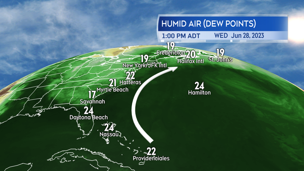
Humid air from the subtropical Atlantic continues to circulate from near the Bahamas, up the U.S. eastern seaboard, and directly into the Maritimes. That air cools and lifts as it arrives and so a lot of that moisture condenses out into cloud, showers, drizzle, and fog.
 We can keep track of the progress of the subtropical sourced air through high dew point temperatures. Currently they extend all the way up the U.S. eastern seaboard and into Atlantic Canada.
We can keep track of the heavy, moisture filled air by looking at dew point temperatures. When dew point temperatures climb into the high-teens and low-twenties it becomes an uncomfortable level of humid for many.
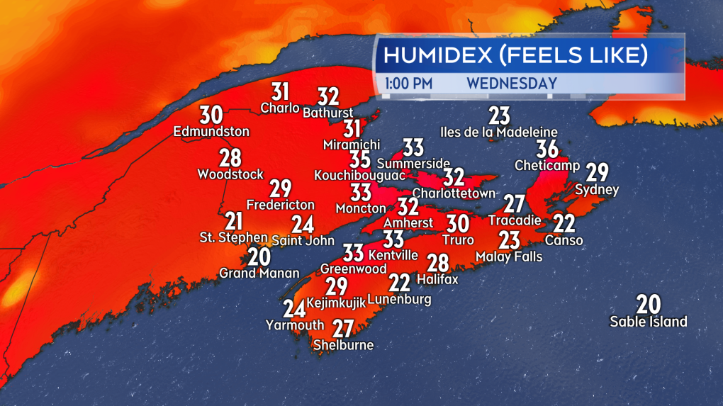
This week prepare for humidex values that will make it feel into the high twenties and low thirties at times despite most air temperature peaking in the low-to-mid twenties.
 Despite modest late June air temperatures the humidity in the air is making it feel into the high twenties and low thirties for many.
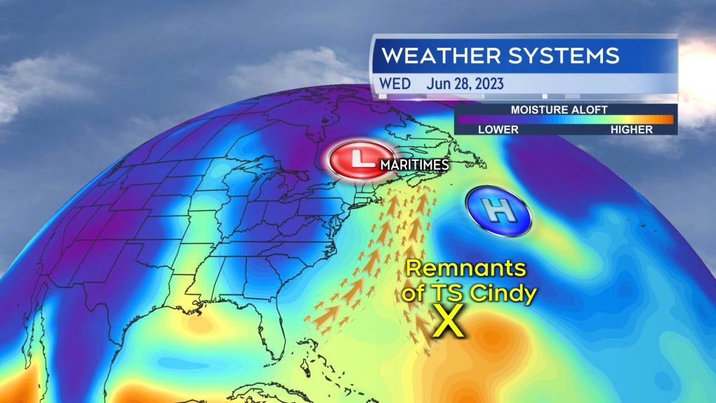
We also appear to have tapped into an additional source of moisture. A second band of very humid air has now developed from the remnants of Tropical Storm Cindy that sits to the south of the Bahamas. While it may now be disorganized showers and thunderstorms, it still packs a lot moisture. That second stream moving in now further increases the risk of thunderstorms and downpours within our periods of showers.
 A second flow of moisture from the remnants of Tropical Storm Cindy further increases our risk of downpours and thunderstorms.
The high rainfall rates within the thunderstorms and downpours can be hazardous. Driving into one will bring visibility down suddenly and flash flooding/hydroplaning conditions are possible. Environment Canada has issued a special weather statement for the Bay of Fundy coastline of New Brunswick, cautioning on rain totals that could reach or exceed the range of 30 to 50 millimetres through Thursday.
I would also include Nova Scotia in the risk of seeing at least local amounts in that range due to the presence of the downpours and thunderstorms.
The generally humid and damp weather is expected to continue into and through the Canada Day long weekend.
CTVNews.ca Top Stories

opinion Tom Mulcair: Prime Minister Justin Trudeau's train wreck of a final act
In his latest column for CTVNews.ca, former NDP leader and political analyst Tom Mulcair puts a spotlight on the 'spectacular failure' of Prime Minister Justin Trudeau's final act on the political stage.
B.C. mayor gets calls from across Canada about 'crazy' plan to recruit doctors
A British Columbia community's "out-of-the-box" plan to ease its family doctor shortage by hiring physicians as city employees is sparking interest from across Canada, says Colwood Mayor Doug Kobayashi.
'There’s no support': Domestic abuse survivor shares difficulties leaving her relationship
An Edmonton woman who tried to flee an abusive relationship ended up back where she started in part due to a lack of shelter space.
opinion King Charles' Christmas: Who's in and who's out this year?
Christmas 2024 is set to be a Christmas like no other for the Royal Family, says royal commentator Afua Hagan. King Charles III has initiated the most important and significant transformation of royal Christmas celebrations in decades.
Baseball Hall of Famer Rickey Henderson dead at 65, reports say
Rickey Henderson, a Baseball Hall of Famer and Major League Baseball’s all-time stolen bases leader, is dead at 65, according to multiple reports.
Arizona third-grader saves choking friend
An Arizona third-grader is being recognized by his local fire department after saving a friend from choking.
Germans mourn the 5 killed and 200 injured in the apparent attack on a Christmas market
Germans on Saturday mourned the victims of an apparent attack in which authorities say a doctor drove into a busy outdoor Christmas market, killing five people, injuring 200 others and shaking the public’s sense of security at what would otherwise be a time of joy.
Blake Lively accuses 'It Ends With Us' director Justin Baldoni of harassment and smear campaign
Blake Lively has accused her 'It Ends With Us' director and co-star Justin Baldoni of sexual harassment on the set of the movie and a subsequent effort to “destroy' her reputation in a legal complaint.
Oysters distributed in B.C., Alberta, Ontario recalled for norovirus contamination
The Canadian Food Inspection Agency has issued a recall due to possible norovirus contamination of certain oysters distributed in British Columbia, Alberta and Ontario.


