
HALIFAX -- A slow-moving weather front will bring a prolonged rainfall to parts of the Maritimes starting Thursday and into Easter weekend.
Rain develops Thursday morning through noon for much of New Brunswick and western Nova Scotia. The rain will spread across Prince Edward Island and eastern mainland Nova Scotia afternoon into evening. The rain will reach Cape Breton from 8 p.m. to midnight.
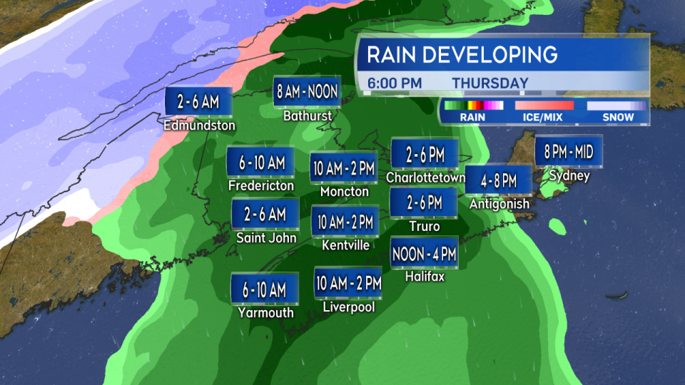
General times at select locations to watch for a steadier rain to start across the Maritimes.
The slow-moving front then stalls over eastern Nova Scotia and P.E.I. on Friday. This means that relatively dry conditions are possible for much of western New Brunswick and southwestern Nova Scotia by Friday afternoon. Rain will continue to fall on Halifax and eastern parts of Nova Scotia as well as for Prince Edward Island. That divide in conditions looks likely to continue into Saturday.
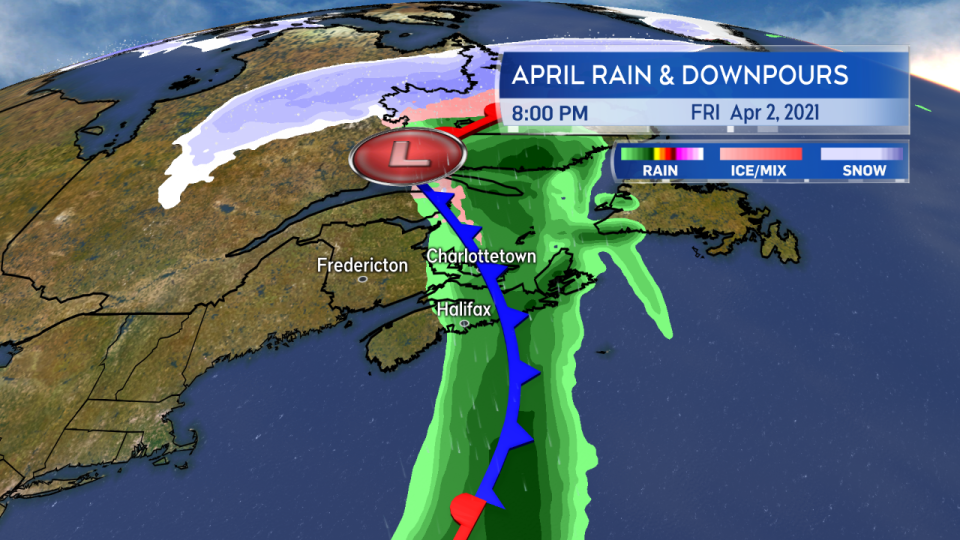
The front may stall over eastern parts of the Maritimes Friday continuing rain there into Saturday with relatively dry conditions, or just a chance of showers, for western areas.
Given that outlook, it's no surprise that higher rainfall amounts ranging 40 to 80-plus millimetres (mm) are indicated for eastern parts of the Maritimes. New Brunswick and western Nova Scotia with totals ranging 20 to 60 mm.
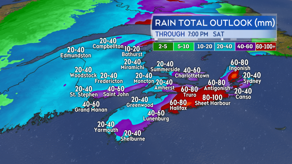
A good soaking for most of the Maritimes but with higher rainfall totals in a range of 40 to 80-plus mm looking more likely for P.E.I. and Halifax and east across Nova Scotia.
While that rain is totalled over a timespan of 48 to 60 hours, it's enough that there may be issues with ponding water and water runoff. Check drainage on your property to ensure it is free and clear of debris. If your basement is prone to flooding and you operate a sump pump be sure it is in working order. Be aware that during the rain there are likely to be some downpours that can reduce visibility and lead to hydroplaning conditions on roads.
If you are in New Brunswick and near the river system monitor River Watch New Brunswick for the latest on ice jams, movement, and water levels.
The area of rain (snow-rain mix for New Brunswick) does look likely to retro-grade, returning east-to-west, for the entirety of the Maritimes on Sunday. You may want to have plans for an indoor Easter egg hunt this year.
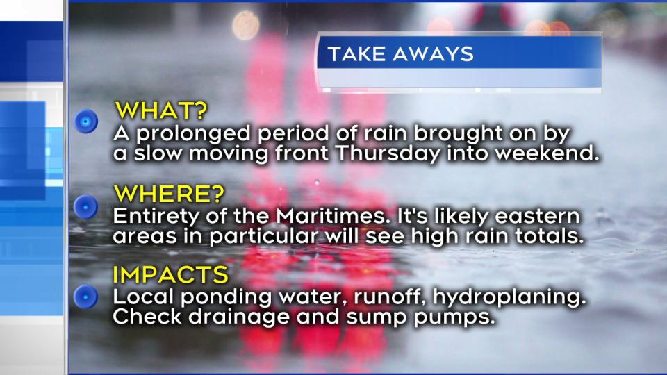
Though the rain comes through over the course of a few days, it's enough that water ponding or runoff could occur. Visibility on roads could be reduced by falling rain and hydroplaning conditions may be present.
Wind will be gusty along the front particularly as it initially comes in on Thursday. South to southeast gusts of 40 to 70 km/h can be expected across much of the Maritimes tomorrow. Due to the topography of the Highlands gusts for northern Inverness County Cape Breton could reach in excess of 100 km/h late Thursday into Friday.
The wind direction will also be out of the northwest for the northwestern corner of New Brunswick as they end up on the colder side of the front. That brings a risk of freezing rain Thursday afternoon into Friday morning for that area.
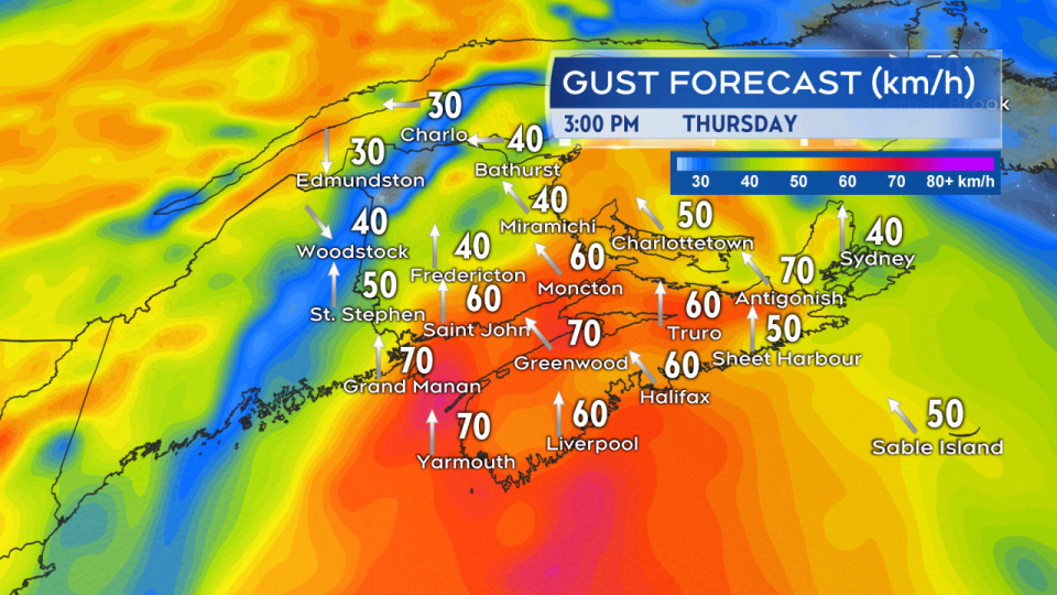
High south and southeast winds will accompany the arrival of the front Thursday. Widespread gusts 40 to 70 km/h are expected in the region.
Some initial weather statements and rainfall warnings have been issued by Environment Canada. You should check in on any alerts active for your area over the next few days.


