Snowfall warnings issued for Cape Breton as cold front moves across the region
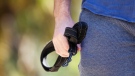
 A person clears snow with a snowblower following a major winter storm in Halifax on Friday, March 3, 2023. (THE CANADIAN PRESS/Darren Calabrese)
A cold front bringing in a mix of snow and rain will continue into eastern parts of the Maritimes Thursday evening and night.
The inclement weather has come with squall-like conditions, producing brief periods of heavier snow, reducing visibility and creating some accumulation. The system slows Thursday night in the vicinity of Cape Breton, keeping that part of the Maritimes in a more prolonged period of snow.
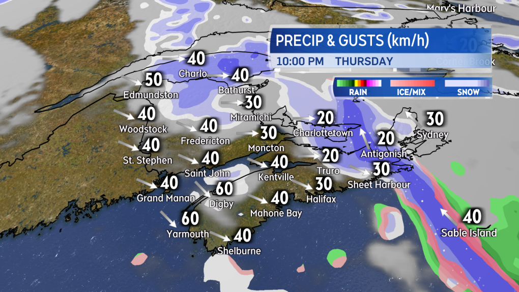 Snow advances into eastern areas of the Maritimes Thursday evening and night along with the cold front.
Environment Canada has issued a snowfall warning for Cape Breton. The warning cautions on snow amounts of 10 to 20 cm Thursday night through Friday morning. The agency also remarks, “the snowfall will likely be quite variable across the Island.”
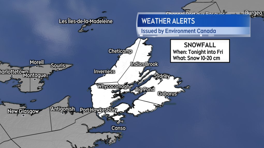 A Snowfall warning is in effect for Cape Breton.
Cape Breton has had more than its share of snow this March. The Sydney Airport reporting 81 cm so far, with the 30-year climate average for the month at 48 cm.The weather station at North Mountain in Victoria County is reporting 142 cm of snow on the ground, which does trail the record of 217 cm reported at the site on March 30, 2001.
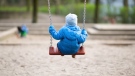
The spring snow has been a boon for some of the ski areas in Cape Breton with Ski Cape Smokey remaining open into Easter weekend.
Friday morning, snow in Cape Breton is expected to ease to a chance of flurries by the afternoon.
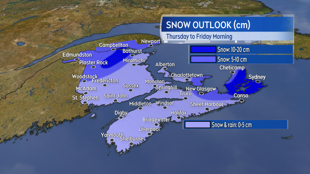 Some of the more mountainous terrain in northern New Brunswick along with Cape Breton are the areas in the Maritimes most likely to see a snowfall of 10+ cm.
The next weather system to impact the Maritimes will arrive on the weekend. A strong low will move from southern Ontario and into the St. Lawrence River Valley.
The weather fronts from the system will come across the Maritimes Saturday into Sunday. Snow turning to rain will develop across the region, west-to-east, Saturday morning into the afternoon.
The snow may accumulate a slushy five to 10 cm in northern areas of New Brunswick. Scattered showers and flurries will linger in the wake of the system on Sunday along with a gusty northwest wind.
Forecast updates and regional weather conditions on CTV News Atlantic 5, 6, and 11:30 p.m.


CTVNews.ca Top Stories
DEVELOPING
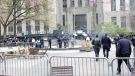
DEVELOPING Man sets self on fire outside New York court where Trump trial underway
A man set himself on fire on Friday outside the New York courthouse where Donald Trump's historic hush-money trial was taking place as jury selection wrapped up, but officials said he did not appear to have been targeting Trump.
Mandisa, Grammy award-winning 'American Idol' alum, dead at 47
Soulful gospel artist Mandisa, a Grammy-winning singer who got her start as a contestant on 'American Idol' in 2006, has died, according to a statement on her verified social media. She was 47.
She set out to find a husband in a year. Then she matched with a guy on a dating app on the other side of the world
Scottish comedian Samantha Hannah was working on a comedy show about finding a husband when Toby Hunter came into her life. What happened next surprised them both.
'It could be catastrophic': Woman says natural supplement contained hidden painkiller drug
A Manitoba woman thought she found a miracle natural supplement, but said a hidden ingredient wreaked havoc on her health.
Young people 'tortured' if stolen vehicle operations fail, Montreal police tell MPs
One day after a Montreal police officer fired gunshots at a suspect in a stolen vehicle, senior officers were telling parliamentarians that organized crime groups are recruiting people as young as 15 in the city to steal cars so that they can be shipped overseas.
Vicious attack on a dog ends with charges for northern Ont. suspect
Police in Sault Ste. Marie charged a 22-year-old man with animal cruelty following an attack on a dog Thursday morning.
The Body Shop Canada explores sale as demand outpaces inventory: court filing
The Body Shop Canada is exploring a sale as it struggles to get its hands on enough inventory to keep up with "robust" sales after announcing it would file for creditor protection and close 33 stores.
Tropical fish stolen from Beachburg, Ont. restaurant found and returned
Ontario Provincial Police have landed a suspect following a fishy theft in Beachburg, Ont.
U.S. FAA launches investigation into unauthorized personnel in cockpit of Colorado Rockies flight to Toronto
The U.S.’s Federal Aviation Administration is investigating a video that appears to show unauthorized personnel in the cockpit of a charted Colorado Rockies flight to Toronto.
Shopping Trends
The Shopping Trends team is independent of the journalists at CTV News. We may earn a commission when you use our links to shop. Read about us.


Toronto
-

Ontario early childhood educators still waiting for promised 2024 wage increases
Ontario Registered Early Childhood Educators (RECEs) are still waiting for their promised 2024 wage increases and advocates say the delay is causing stress for workers.
-
U.S. FAA launches investigation into unauthorized personnel in cockpit of Colorado Rockies flight to Toronto
The U.S.’s Federal Aviation Administration is investigating a video that appears to show unauthorized personnel in the cockpit of a charted Colorado Rockies flight to Toronto.
-
WATCH
WATCH Video shows dramatic police takedown of carjacking suspects chased through parking lot north of Toronto
Police have released video footage of a dramatic takedown of a group of teens wanted in connection with an attempted carjacking in Markham earlier this month.
Calgary
-

Calgary man accused in toddler death released on bail
Winston Campbell granted bail at first court appearance
-
Voluntary water limits put in place in face of possible Alberta drought
More than three dozen of Alberta's largest water users have agreed with a provincial plan to cut back on water usage this year ahead of a severe drought expected this summer.
-
Calgary Stampede announces 2024 Grandstand Show headliners
Canadian music group Hunter Brothers will headline the 2024 Calgary Stampede Grandstand Show.
Edmonton
-

Bromazolam, drug linked to New Brunswick deaths, found at scene of Alberta overdose
A substance that was linked to a string of fatal overdoses in New Brunswick in 2022 has been found in Alberta for the first time, Mounties are warning the public.
-
Windows smashed at several Beaumont restaurants
Cleanup is underway after three businesses in Beaumont were vandalized.
-
Oilers host Los Angeles Kings on Monday in Game 1 of playoffs
The National Hockey League has confirmed the schedule for the first four Edmonton Oilers playoff games.
Montreal
-

Young people 'tortured' if stolen vehicle operations fail, Montreal police tell MPs
One day after a Montreal police officer fired gunshots at a suspect in a stolen vehicle, senior officers were telling parliamentarians that organized crime groups are recruiting people as young as 15 in the city to steal cars so that they can be shipped overseas.
-
Rabid raccoon sighting prompts Quebec ministry to employ rabies vaccine plan
After a rabid raccoon was reported in Vermont, 10 kilometres from the Quebec border, the provincial Environment Ministry will distribute vaccine bait in 17 municipalities in the Eastern Townships and Monteregie.
-
Woman stabbed at motel in Montreal's west end
A 39-year-old woman was sent to hospital with serious injuries after police say she was stabbed inside a motel room in Montreal's west end Friday morning.
Ottawa
-

Tropical fish stolen from Beachburg, Ont. restaurant found and returned
Ontario Provincial Police have landed a suspect following a fishy theft in Beachburg, Ont.
-
Will parking remain free in Wellington West and Westboro? City studying parking options
Time could soon run out on free on-street parking in Ottawa's Westboro, Wellington West and Hintonburg neighbourhoods.
-
OPP reminds drone operators it's illegal to operate a drone near emergency sites following Hwy. 417 fatal crash
Ontario Provincial Police are reminding people that it is illegal to fly a drone over traffic collision sites, after drone footage captured over a fatal crash on Hwy. 417 in Ottawa appeared online.
London
-
No more train trauma for Adelaide Street commuters
‘Onto Adelaide and just zip down’: Cars no longer have to deal with trains on Adelaide Street North, near Central Avenue.
-
$80-million agreement for Central Elgin over annexed land for Volkswagen plant
The $80-million agreement announced Friday is said to include monetary compensation and infrastructure to grow industrial and residential tax bases.
-
City councillor says encampment response falls short and comes too late
A city councillor said she’s concerned the city is encouraging homeless encampments rather than finding more permanent solutions.
Barrie
-

Serious rollover on Highway 400 sends mother to hospital
Person airlifted to Toronto after a rollover on Highway 400 Friday morning.
-
Court hearing for former NHLer and Barrie police officer facing extortion charges
Barrie police Insp. Valarie Gates testified in the preliminary hearing for suspended Sgt. Bruce Gardiner, who stands charged with extortion and criminal harassment.
-
Break-in leaves Barrie home with considerable water damage
Police are hoping to identify the person(s) who allegedly broke into a Barrie home and caused extensive water damage.
Northern Ontario
-
Vicious attack on a dog ends with charges for northern Ont. suspect
Police in Sault Ste. Marie charged a 22-year-old man with animal cruelty following an attack on a dog Thursday morning.
-
Sault College president sues Conestoga counterpart, seeks formal apology for vulgar attack
The war of words between the presidents of Sault College and Conestoga College has escalated into a legal battle.
-
DEVELOPING
DEVELOPING Man sets self on fire outside New York court where Trump trial underway
A man set himself on fire on Friday outside the New York courthouse where Donald Trump's historic hush-money trial was taking place as jury selection wrapped up, but officials said he did not appear to have been targeting Trump.
Kitchener
-

Kitchener golfer recognized as creator of Masters skip-shot tradition
A Canadian Hall of Fame golfer from Kitchener is finally getting recognition for starting the skip-shot tradition at The Masters.
-
KW Glee, music school suspend employee over sexual assault charge
Two Kitchener-Waterloo music organizations have placed an employee on a leave of absence after he was charged in a historical sexual assault investigation.
-
NDP compares proposed Wilmot land acquisition to Green Belt scandal ahead of town hall
Ontario NDP leader Marit Stiles is in Wilmot Township today railing against a plan to turn 770-acres of farmland into an industrial site.
Windsor
-
One driver charged, one sought after crash at apparent 'unsanctioned' rally
Windsor police have charged a 21-year-old man with stunt driving following a collision at a commercial property.
-
Body recovered from Detroit River
An investigation is underway after a body was pulled from the Detroit River.
-
Threat investigated at Walkerville Collegiate
Windsor police are investigating a threat at a Walkerville high school.
Winnipeg
-

'Final sunset': Tiber River to cease operations
Tiber River, a shop that sells natural body care products, is ceasing operations.
-
'It could be catastrophic': Woman says natural supplement contained hidden painkiller drug
A Manitoba woman thought she found a miracle natural supplement, but said a hidden ingredient wreaked havoc on her health.
-
Streaking Jets prepare for playoff clash with star-studded Avalanche
The Winnipeg Jets will face the Colorado Avalanche for the first time ever in the Stanley Cup Playoffs
Regina
-

Jury deliberations underway for Sask. father accused of abducting daughter
Following two full weeks of proceedings, a Regina judge ordered a 12 person jury to deliberate their decision for Michael Gordon Jackson.
-
New crash course focused on getting Sask. youth excited about journalism
Fifteen youth from a variety of backgrounds are taking on the monumental task of creating and performing a live radio broadcast with on seven days to prepare. The goal of the project is to get more youth excited about journalism.
-
SaskPower investing $13.5M in Regina's downtown electrical grid
SaskPower says it will be investing $13.5 million in an effort to improve downtown Regina's electrical grid.
Saskatoon
-

Saskatoon police to search landfill for remains of woman missing since 2020
Saskatoon police say they will begin searching the city’s landfill for the remains of Mackenzie Lee Trottier, who has been missing for more than three years.
-
Saskatoon libraries changing hours after 2 teens assaulted an employee, security guard
Libraries in Saskatoon will be closing earlier after an employee and security guard were allegedly assaulted at the Carlyle King Library Monday night.
-
New Sask. dental hygienist degree program to offer strictly evening classes
A new dental hygienist degree program is launching at the University of Saskatchewan (U of S) in September to help meet a growing demand for oral health specialists.
Vancouver
-

Trudeau non-committal on funding B.C. First Nation's orca rescue efforts
The B.C. First Nation involved in the ongoing effort to rescue a stranded killer whale calf on Vancouver Island has asked the government for financial support – but Prime Minister Justin Trudeau was non-committal when asked about the request Friday.
-
$1.1M lost in just over a month to fraudsters posing as Chinese police: Richmond RCMP
Mounties in Richmond say more than a million dollars was lost to fraudsters posing as police or government officials in just over a month.
-
Vancouver firefighter in rehab at home after losing leg to flesh-eating infection overseas
A family trip took a frightening turn for Christopher Won when he was diagnosed with flesh-eating disease while in Hong Kong and now, after weeks of treatment overseas, the Vancouver firefighter is back home recovering.
Vancouver Island
-

Woman killed, driver sought after hit-and-run crash in Duncan, B.C.
A woman is dead and police are searching for a suspect driver after a hit-and-run crash in Duncan, B.C.
-
Off-duty Mountie cleared of wrongdoing after cyclist seriously injured in Langford, B.C.
British Columbia's police watchdog has cleared an off-duty Mountie of wrongdoing after a cyclist suffered serious injuries in a collision with an unmarked police vehicle last month.
-
Coroner's inquest called into death of man killed in police shootout in Kamloops, B.C.
The British Columbia government has called for a coroner's inquest into the death of a 35-year-old Kamloops man who was killed in a shootout with police nearly six years ago.
Kelowna
-

Stolen snake named Milkshake returned to Kelowna pet store
A banana ball python that was stolen from a Kelowna pet store on Saturday has been returned unharmed, Mounties said.
-
Nurses rally at B.C. Interior hospital over security, staffing concerns
Nurses held a rally Wednesday at a hospital in the B.C. Interior that closed its emergency department more than a dozen times last year due to insufficient staff.
-
B.C. to add 240 complex-care housing units throughout province
British Columbia is planning to add 240 new units to its complex-care housing program, providing homes for people with mental-health and addictions challenges that overlap with other serious conditions.


