Texas low will bring mix of rain and snow to Maritimes Thursday and Friday
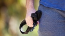
 A pedestrian makes their way through a snowstorm in Halifax on Tuesday, January 31, 2023. (THE CANADIAN PRESS/Darren Calabrese)
A Texas low moving through Ontario into the St. Lawrence River Valley Thursday night into Friday will bring weather fronts, including one with milder air from the US eastern seaboard, across the Maritimes.
The milder air will cause a mix of precipitation for a large portion of the Maritimes.
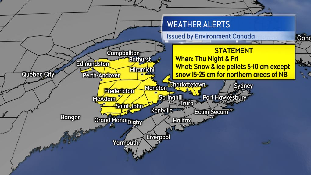 Special weather statements have been issued by Environment Canada for both New Brunswick and Prince Edward Island.
Special weather statements are in effect for both New Brunswick and Prince Edward Island ahead of a mix of snow, ice pellets, freezing rain, and rain arriving Thursday night into Friday.
The statement for New Brunswick calls for snow amounts of 15 to 25 cm for northern areas of the province. Central and southern areas of New Brunswick will see accumulations of five to 10 cm of snow and ice pellets followed by some freezing rain and rain.
For Prince Edward Island, five to 10 cm of snow and ice pellets are expected, before a similar turn to freezing rain and rain.
Travel could become difficult in both provinces on Friday.
Nova Scotia is not currently under a statement, but guidance shows that most of the province can expect two to five cm of snow before it turns to rain. Higher snow amounts of five to 10 cm are possible at higher terrain and in Cape Breton. The rain following the snow looks to range from five to 15 mm.
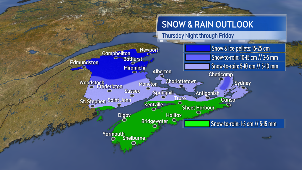 The most snow accumulation will be in northern areas of New Brunswick. Other areas of the Maritimes will see snow turn to freezing rain and rain.
The snow is expected to be into western New Brunswick and western Nova Scotia roughly a few hours after midnight Thursday into Friday. Snow will reach eastern New Brunswick, eastern Nova Scotia, and Prince Edward Island before sunrise Friday.
Friday morning will see the snow turn to freezing rain and rain for all but northern areas of New Brunswick. Snow and rain will gradually end west to east Friday evening. A chance of flurries lingers Friday night into Saturday.
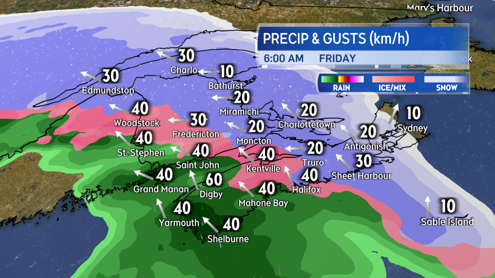 Friday morning commutes could be slippery in the Maritimes, though a turn to rain will already be taking place in southwestern New Brunswick and western Nova Scotia.
The change from snow to rain will be accompanied by a south-turning southwest wind. That wind will increase to become sustained at 20 to 30 km/h with gusts of 30 to 60 km/h on Friday. With northern New Brunswick not switching over to the south wind, colder air will stay in place, which is why that part of the region will pick up more snow.
Wind will turn northwest and diminish for the region Friday night into Saturday morning.


CTVNews.ca Top Stories
DEVELOPING
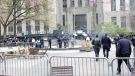
DEVELOPING Man sets self on fire outside New York court where Trump trial underway
A man set himself on fire on Friday outside the New York courthouse where Donald Trump's historic hush-money trial was taking place as jury selection wrapped up, but officials said he did not appear to have been targeting Trump.
BREAKING
BREAKING Sask. father found guilty of withholding daughter to prevent her from getting COVID-19 vaccine
Michael Gordon Jackson, a Saskatchewan man accused of abducting his daughter to prevent her from getting a COVID-19 vaccine, has been found guilty for contravention of a custody order.
She set out to find a husband in a year. Then she matched with a guy on a dating app on the other side of the world
Scottish comedian Samantha Hannah was working on a comedy show about finding a husband when Toby Hunter came into her life. What happened next surprised them both.
Mandisa, Grammy award-winning 'American Idol' alum, dead at 47
Soulful gospel artist Mandisa, a Grammy-winning singer who got her start as a contestant on 'American Idol' in 2006, has died, according to a statement on her verified social media. She was 47.
'It could be catastrophic': Woman says natural supplement contained hidden painkiller drug
A Manitoba woman thought she found a miracle natural supplement, but said a hidden ingredient wreaked havoc on her health.
Young people 'tortured' if stolen vehicle operations fail, Montreal police tell MPs
One day after a Montreal police officer fired gunshots at a suspect in a stolen vehicle, senior officers were telling parliamentarians that organized crime groups are recruiting people as young as 15 in the city to steal cars so that they can be shipped overseas.
The Body Shop Canada explores sale as demand outpaces inventory: court filing
The Body Shop Canada is exploring a sale as it struggles to get its hands on enough inventory to keep up with "robust" sales after announcing it would file for creditor protection and close 33 stores.
Vicious attack on a dog ends with charges for northern Ont. suspect
Police in Sault Ste. Marie charged a 22-year-old man with animal cruelty following an attack on a dog Thursday morning.
On federal budget, Macklem says 'fiscal track has not changed significantly'
Bank of Canada governor Tiff Macklem says Canada's fiscal position has 'not changed significantly' following the release of the federal government's budget.
Shopping Trends
The Shopping Trends team is independent of the journalists at CTV News. We may earn a commission when you use our links to shop. Read about us.


Toronto
-

Ontario early childhood educators still waiting for promised 2024 wage increases
Ontario Registered Early Childhood Educators (RECEs) are still waiting for their promised 2024 wage increases and advocates say the delay is causing stress for workers.
-
U.S. FAA launches investigation into unauthorized personnel in cockpit of Colorado Rockies flight to Toronto
The U.S.’s Federal Aviation Administration is investigating a video that appears to show unauthorized personnel in the cockpit of a charted Colorado Rockies flight to Toronto.
-
WATCH
WATCH Video shows dramatic police takedown of carjacking suspects chased through parking lot north of Toronto
Police have released video footage of a dramatic takedown of a group of teens wanted in connection with an attempted carjacking in Markham earlier this month.
Calgary
-

From 'barely surviving, to living': Calgary family champions local mental health supports
It seemed like their world was crashing in when free mental health services changed the lives of a Calgary family and now they are trying to help others get the same support.
-
Calgary man accused in toddler death released on bail
Winston Campbell granted bail at first court appearance
-
Voluntary water limits put in place in face of possible Alberta drought
More than three dozen of Alberta's largest water users have agreed with a provincial plan to cut back on water usage this year ahead of a severe drought expected this summer.
Edmonton
-

Spit, punches and bites: School support staff detail rising violence from students
A former educational assistant is calling attention to the rising violence in Alberta's classrooms.
-
Bromazolam, drug linked to New Brunswick deaths, found at scene of Alberta overdose
A substance that was linked to a string of fatal overdoses in New Brunswick in 2022 has been found in Alberta for the first time, Mounties are warning the public.
-
Windows smashed at several Beaumont restaurants
Cleanup is underway after three businesses in Beaumont were vandalized.
Montreal
-

Young people 'tortured' if stolen vehicle operations fail, Montreal police tell MPs
One day after a Montreal police officer fired gunshots at a suspect in a stolen vehicle, senior officers were telling parliamentarians that organized crime groups are recruiting people as young as 15 in the city to steal cars so that they can be shipped overseas.
-
Woman stabbed at motel in Montreal's west end
A 39-year-old woman was sent to hospital with serious injuries after police say she was stabbed inside a motel room in Montreal's west end Friday morning.
-
Iconic ninth floor Eaton Centre restaurant set to reopen in May
There was once a beautiful restaurant on the ninth floor of the former Eaton's department store. It closed 25 years ago, but many in Montreal still talk about it. Soon, Le 9ieme will open to diners once again.
Ottawa
-

Will parking remain free in Wellington West and Westboro? City studying parking options
Time could soon run out on free on-street parking in Ottawa's Westboro, Wellington West and Hintonburg neighbourhoods.
-
Tropical fish stolen from Beachburg, Ont. restaurant found and returned
Ontario Provincial Police have landed a suspect following a fishy theft in Beachburg, Ont.
-
OPP reminds drone operators it's illegal to operate a drone near emergency sites following Hwy. 417 fatal crash
Ontario Provincial Police are reminding people that it is illegal to fly a drone over traffic collision sites, after drone footage captured over a fatal crash on Hwy. 417 in Ottawa appeared online.
London
-

No more train trauma for Adelaide Street commuters
‘Onto Adelaide and just zip down’: Cars no longer have to deal with trains on Adelaide Street North, near Central Avenue.
-
Witness insists they are telling the truth at sexual abuse trial
A witness at the sexual assault trial involving parents is adamant the children involved in the trial are all telling the truth about what they had to endure during their upbringing.
-
City councillor says encampment response falls short and comes too late
A city councillor said she’s concerned the city is encouraging homeless encampments rather than finding more permanent solutions.
Barrie
-
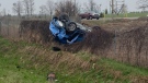
Driver charged after Highway 400 crash sends woman and child to hospital
One person has been charged following a collision on Highway 400 in Barrie Friday morning that sent a vehicle rolling into a ditch.
-
Curling legend Glenn Howard reflects on his career & what's next
In an interview with CTV's Rob Cooper, conducted just two days into his retirement, Howard reflects on his illustrious career and what lies ahead.
-
Court hearing for former NHLer and Barrie police officer facing extortion charges
Barrie police Insp. Valarie Gates testified in the preliminary hearing for suspended Sgt. Bruce Gardiner, who stands charged with extortion and criminal harassment.
Northern Ontario
-
Vicious attack on a dog ends with charges for northern Ont. suspect
Police in Sault Ste. Marie charged a 22-year-old man with animal cruelty following an attack on a dog Thursday morning.
-
Sault College president sues Conestoga counterpart, seeks formal apology for vulgar attack
The war of words between the presidents of Sault College and Conestoga College has escalated into a legal battle.
-
DEVELOPING
DEVELOPING Man sets self on fire outside New York court where Trump trial underway
A man set himself on fire on Friday outside the New York courthouse where Donald Trump's historic hush-money trial was taking place as jury selection wrapped up, but officials said he did not appear to have been targeting Trump.
Kitchener
-

Kitchener golfer recognized as creator of Masters skip-shot tradition
A Canadian Hall of Fame golfer from Kitchener is finally getting recognition for starting the skip-shot tradition at The Masters.
-
KW Glee, music school suspend employee over sexual assault charge
Two Kitchener-Waterloo music organizations have placed an employee on a leave of absence after he was charged in a historical sexual assault investigation.
-
NDP compares proposed Wilmot land acquisition to Green Belt scandal ahead of town hall
Ontario NDP leader Marit Stiles is in Wilmot Township today railing against a plan to turn 770-acres of farmland into an industrial site.
Windsor
-

'My family’s suffering still hasn’t ended’: Faint Hope hearing evidence concludes with victim impact statements
A Windsor man convicted in a violent murder 20 years ago awaits ruling on bid for early parole.
-
One driver charged, one sought after crash at apparent 'unsanctioned' rally
Windsor police have charged a 21-year-old man with stunt driving following a collision at a commercial property.
-
Body recovered from Detroit River
An investigation is underway after a body was pulled from the Detroit River.
Winnipeg
-

Tiber River ceasing operations
Tiber River, a shop that sells natural body care products, is ceasing operations.
-
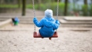
Manitoba mom praises quick-thinking fire department for freeing daughter stuck in playground equipment
A Manitoba mother is praising firefighters for their quick work in helping her daughter who got stuck at a playground in Lorette, Man.
-
Winnipeg woman in hospital after being hit by tractor-trailer
One woman is in hospital after being hit by a tractor-trailer on Thursday night in North Kildonan.
Regina
-
 BREAKING
BREAKING Sask. father found guilty of withholding daughter to prevent her from getting COVID-19 vaccine
Michael Gordon Jackson, a Saskatchewan man accused of abducting his daughter to prevent her from getting a COVID-19 vaccine, has been found guilty for contravention of a custody order.
-
Saskatoon police to search landfill for remains of woman missing since 2020
Saskatoon police say they will begin searching the city’s landfill for the remains of Mackenzie Lee Trottier, who has been missing for more than three years.
-
New crash course focused on getting Sask. youth excited about journalism
Fifteen youth from a variety of backgrounds are taking on the monumental task of creating and performing a live radio broadcast with on seven days to prepare. The goal of the project is to get more youth excited about journalism.
Saskatoon
-

Saskatoon police to search landfill for remains of woman missing since 2020
Saskatoon police say they will begin searching the city’s landfill for the remains of Mackenzie Lee Trottier, who has been missing for more than three years.
-
BREAKING
BREAKING Sask. father found guilty of withholding daughter to prevent her from getting COVID-19 vaccine
Michael Gordon Jackson, a Saskatchewan man accused of abducting his daughter to prevent her from getting a COVID-19 vaccine, has been found guilty for contravention of a custody order.
-
'We've reached a breaking point': Saskatoon libraries reducing hours amid workplace violence
Some libraries in Saskatoon will be closing earlier after an employee and security guard were allegedly assaulted at the Carlyle King Library Monday night.
Vancouver
-

Mounties arrest 7 after 'significant' seizure of drugs, guns on Vancouver Island
Mounties say seven people have been arrested after a series of co-ordinated property searches on Vancouver Island yielded multiple firearms, including 3D-printed handguns, and several kilograms of drugs.
-
2 people threatened with imitation gun in Downtown Eastside, police say
A 31-year-old man has been charged after allegedly threatening two people with an imitation gun in Vancouver's Downtown Eastside this week.
-
Trudeau non-committal on funding B.C. First Nation's orca rescue efforts
The B.C. First Nation involved in the ongoing effort to rescue a stranded killer whale calf on Vancouver Island has asked the government for financial support – but Prime Minister Justin Trudeau was non-committal when asked about the request Friday.
Vancouver Island
-
Mounties arrest 7 after 'significant' seizure of drugs, guns on Vancouver Island
Mounties say seven people have been arrested after a series of co-ordinated property searches on Vancouver Island yielded multiple firearms, including 3D-printed handguns, and several kilograms of drugs.
-
Woman killed, driver sought after hit-and-run crash in Duncan, B.C.
A woman is dead and police are searching for a suspect driver after a hit-and-run crash in Duncan, B.C.
-
Off-duty Mountie cleared of wrongdoing after cyclist seriously injured in Langford, B.C.
British Columbia's police watchdog has cleared an off-duty Mountie of wrongdoing after a cyclist suffered serious injuries in a collision with an unmarked police vehicle last month.
Kelowna
-
Stolen snake named Milkshake returned to Kelowna pet store
A banana ball python that was stolen from a Kelowna pet store on Saturday has been returned unharmed, Mounties said.
-
Nurses rally at B.C. Interior hospital over security, staffing concerns
Nurses held a rally Wednesday at a hospital in the B.C. Interior that closed its emergency department more than a dozen times last year due to insufficient staff.
-
B.C. to add 240 complex-care housing units throughout province
British Columbia is planning to add 240 new units to its complex-care housing program, providing homes for people with mental-health and addictions challenges that overlap with other serious conditions.


