Thunderstorms produce lightning, downpours; risk continues into Thursday evening and night
The combination of warm, humid air that has built up this week along with an arriving cold front from the west has triggered rounds of thunderstorms in the Maritimes.
Thunderstorms came across northern areas of New Brunswick Thursday morning into early afternoon. Along with lightning, the thunderstorms are producing some rainfall rates as high as 20 to 40 mm/hr. That heavy of a rainfall can reduce visibility and lead to pooling water on roads. The storms are moving quickly eastward at 50 to 60 km/h. The fast speed of the storms does reduce the risk of flooding.
Thursday afternoon risk
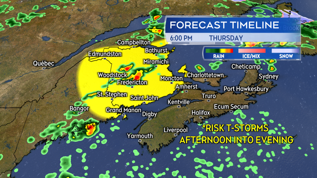
A second round of showers and broken thunderstorms is expected to develop and move across New Brunswick Thursday afternoon into evening. The risk begins first in the northwest region of the province early in the afternoon. The risk of thunderstorms then becomes more widespread late afternoon and through the first part of the evening for the province. During that time, there is also a risk for western Prince Edward Island. The risk for thunderstorms for New Brunswick and western P.E.I. should be diminished by 8 to 10 p.m.
 A second round of scattered thunderstorms is expected to develop and move west-to-east across New Brunswick Thursday afternoon into evening.
A severe thunderstorm watch that was issued for most of New Brunswick earlier in the day Thursday has been dropped, as well as a tornado watch that was issued for Victoria County and Mount Carleton - Renous Highway.
Around 5:30 p.m., Environment Canada issued the tornado watch for the two areas, warning that strong winds, large hail and heavy rain were also possible.
Thursday night risk
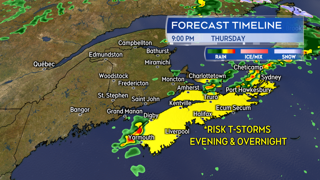
As the front triggering the thunderstorms moves towards P.E.I. and Nova Scotia Thursday night, the risk of thunderstorms for both of those provinces will rise. The risk of thunderstorms for P.E.I. will be highest between 6 p.m. and midnight. The risk of thunderstorms for Nova Scotia is highest from 8 p.m. to 2 a.m. Guysborough, Richmond, and Cape Breton counties in eastern Nova Scotia continue with a lower risk until near 6 a.m. Friday.
The thunderstorms will be scattered in coverage, so not every community will have one pass over. Lightning will be the most common hazard with the thunderstorms. Some may be capable of producing heavy downpours.
 An increased risk of thunderstorms for Thursday night and overnight for Nova Scotia and Prince Edward Island.
Temperatures and humidity outlook
There is less humid air located behind the front. Much of the mugginess of the week will be out of the air for New Brunswick on Friday and falling for both Nova Scotia and P.E.I.
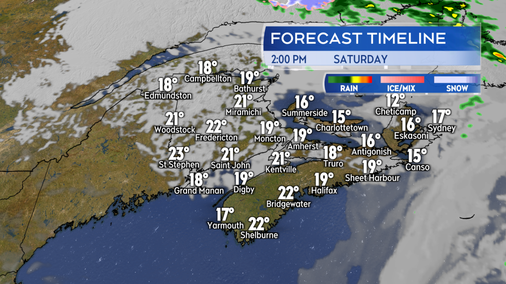
High temperatures are still expected to be well above average for late May on Friday. Areas off the coastline will once again likely reach the mid-to-high 20s. High temperatures will cool for Saturday with high-teens and low-twenties for New Brunswick and mainland Nova Scotia. Closer to the mid-teens are expected for P.E.I. and Cape Breton.
 A nice enough start to the weekend. Mixed sun and cloud, air a bit cooler and drier compared to much of this week.
CTVNews.ca Top Stories

Poilievre writes to GG calling for House recall, confidence vote after Singh declares he's ready to bring Liberals down
Conservative Leader Pierre Poilievre has written to Gov. Gen. Mary Simon, imploring her to 'use your authority to inform the prime minister that he must' recall the House of Commons so a non-confidence vote can be held. This move comes in light of NDP Leader Jagmeet Singh publishing a letter stating his caucus 'will vote to bring this government down' sometime in 2025.
School custodian stages surprise for Kitchener, Ont. students ahead of holiday break
He’s no Elf on the Shelf, but maybe closer to Ward of the Board.
Kelly Clarkson's subtle yet satisfying message to anyone single this Christmas
The singer and daytime-talk show host released a fireside video to accompany her 2021 holiday album, “When Christmas Comes Around” that she dubbed, “When Christmas Comes Around…Again.
Judge sentences Quebecer convicted of triple murder who shows 'no remorse'
A Quebecer convicted in a triple murder on Montreal's South Shore has been sentenced to life in prison without chance of parole for 20 years in the second-degree death of Synthia Bussieres.
At least 2 dead, 60 hurt after car drives into German Christmas market in suspected attack
A car plowed into a busy outdoor Christmas market in the eastern German city of Magdeburg on Friday, killing at least two people and injuring at least 60 others in what authorities suspect was an attack.
16-year-old German exchange student dies after North Vancouver crash
A 16-year-old high school student from Germany who was hit by a Jeep in North Vancouver, B.C., last weekend has died in hospital, authorities confirmed.
Poilievre to Trump: 'Canada will never be the 51st state'
Conservative leader Pierre Poilievre is responding to U.S. president-elect Donald Trump’s ongoing suggestions that Canada become the 51st state, saying it will 'never happen.'
Canadiens executive says he has 'no concern' about members of the front office travelling to Russia
Montreal executive vice president of hockey operations Jeff Gorton said he has 'no concern' about members of the Canadiens' front office travelling to Russia with the country’s war in Ukraine ongoing.
Speeding drivers get holiday surprise from 'Officer Grinch'
Drivers in the Florida Keys who exceed the speed limit in school zones may run into a well-known gloomy green creature and get a surprising 'gift.'


