Very hot, humid weather on deck for the Maritimes Monday and Tuesday

HALIFAX -
Environment Canada has released a statement of new area high temperature records set on Monday throughout the Maritimes.
The temperature records were derived from a selection of historical stations in the each geographic area. They do note that it is an initial summary and does not constitute a complete or final report.
CTV Atlantic Meteorologist Kalin Mitchell selected a few of the records given.
The original lists of records can be found on the Government of Canada website.
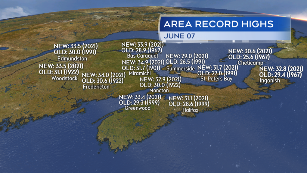
Select area high temperature records set on June 7th, 2021 per Environment Canada.
The Maritimes are in the midst of a stretch of very hot and humid weather.
A combination of high pressure to our east and a low sitting well to the northwest is forcing in hot, continental air that originates out of the US southwest.
 Heat Warnings issued by Environment Canada for New Brunswick, Nova Scotia, and Prince Edward Island.
Heat warnings have been issued for much of central/southern New Brunswick, mainland Nova Scotia, and Prince Edward Island. The current warnings are expected to extend into Tuesday. Heat warning criteria differs slightly from province to province but generally requires two days of hot days and warm nights. Humidex (what it feels like when temperature and humidity are accounted for) may also be used as criteria.

Criteria used for the issuance of Heat Warnings for the Maritime provinces.
People and pets should not be left in hot cars for any period of time. This applies to anytime we have sunny and warm-to-hot weather. Stay hydrated and take breaks to cool when possible. Watch the more vulnerable (young, elderly) for signs of heat exhaustion and stroke. That can include weakness, nausea, headache, muscle cramps, and in the most serious cases, a loss of consciousness or reduced mental ability.
Tuesday is likely to be the hottest, most humid day region wide. Most highs away from the coast are expected to reach the low-to-mid 30’s. Parts of the region will cool on Wednesday including eastern areas of New Brunswick, eastern areas of Nova Scotia, and Prince Edward Island as winds turn to the northeast tapping into cooler North Atlantic air. Some heat will linger for western New Brunswick and western Nova Scotia on Wednesday, though is unlikely to match up to Tuesday.

Tuesday is, in general, going to be the hottest day this week.
A round of cooler, less humid polar air arrives in northerly winds Thursday breaking the hot weather region wide. In fact temperatures on Thursday and Friday appear to run at least a few degrees cooler than climate averages for early June.
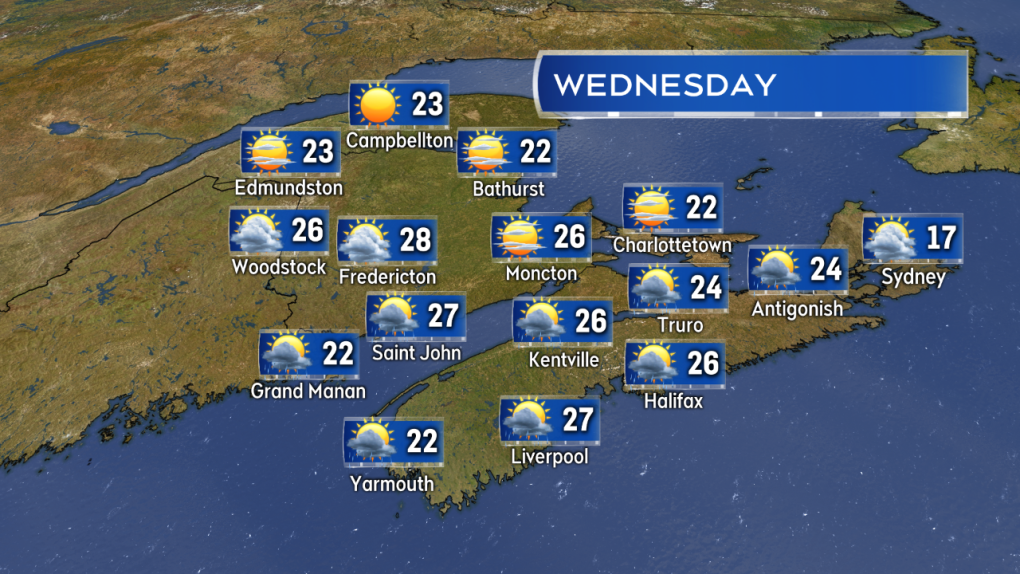 Temperatures begin to cool, especially for eastern areas. Temperatures much cooler region wide on Thursday.
A risk of thunderstorms often accompanies stretches of hot, humid weather. A line of broken thunderstorms may develop in central/southern New Brunswick on Tuesday moving into P.E.I. and eventually Nova Scotia. The thunderstorms should be watched for Tuesday afternoon and evening.

A broken line of thunderstorms may develop Tuesday afternoon into the evening. Thunderstorms should be watched for in central/southern New Brunswick, Nova Scotia, and Prince Edward Island.


CTVNews.ca Top Stories

Doctors say capital gains tax changes will jeopardize their retirement. Is that true?
The Canadian Medical Association asserts the Liberals' proposed changes to capital gains taxation will put doctors' retirement savings in jeopardy, but some financial experts insist incorporated professionals are not as doomed as they say they are.
Something in the water? Canadian family latest to spot elusive 'Loch Ness Monster'
For centuries, people have wondered what, if anything, might be lurking beneath the surface of Loch Ness in Scotland. When Canadian couple Parry Malm and Shannon Wiseman visited the Scottish highlands earlier this month with their two children, they didn’t expect to become part of the mystery.
Fair in Ontario, flurries in Labrador: Weather systems make for an erratic spring
It's no secret that spring can be a tumultuous time for Canadian weather, and as an unseasonably mild El Nino winter gives way to summer, there's bound to be a few swings in temperature that seem out of the ordinary. From Ontario to the Atlantic, though, this week is about to feel a little erratic.
What do weight loss drugs mean for a diet industry built on eating less and exercising more?
Recent injected drugs like Wegovy and its predecessor, the diabetes medication Ozempic, are reshaping the health and fitness industries.
He replaced Mickey Mantle. Now baseball's oldest living major leaguer is turning 100
The oldest living former major leaguer, Art Schallock turns 100 on Thursday and is being celebrated in the Bay Area and beyond as the milestone approaches.
What a urologist wants you to know about male infertility
When opposite sex couples are trying and failing to get pregnant, the attention often focuses on the woman. That’s not always the case.
'It was instant karma': Viral video captures failed theft attempt in Nanaimo, B.C.
Mounties in Nanaimo, B.C., say two late-night revellers are lucky their allegedly drunken antics weren't reported to police after security cameras captured the men trying to steal a heavy sign from a downtown business.
Bank of Canada officials split on when to start cutting interest rates
Members of the Bank of Canada's governing council were split on how long the central bank should wait before it starts cutting interest rates when they met earlier this month.
Made-in-Newfoundland vodka claims top prize at worldwide competition
A Newfoundland-made vodka has been named one of the world’s best by judges at this year’s World Vodka Awards.
Shopping Trends
The Shopping Trends team is independent of the journalists at CTV News. We may earn a commission when you use our links to shop. Read about us.


Toronto
-

It could take years to catch up on child vaccinations in Ontario post-pandemic
Ontario is still playing catch up on routine vaccinations that many children missed during the pandemic and public health officials are warning that it could take years to solve the problem.
-
Honda expected to announce Ontario EV battery plant, part of a $15B investment
Prime Minister Justin Trudeau, Ontario Premier Doug Ford and Honda executives are expected to announce today that the Japanese automaker is building an electric vehicle battery plant in Alliston, Ont., part of a $15-billion investment.
-
Striking AGO workers reach tentative deal, union says
A month after workers at the Art Gallery of Ontario (AGO) walked off the job, their union says a tentative deal has been reached with the gallery.
Calgary
-

Coyote calls on the rise in Calgary; city wildlife team advises caution
The City of Calgary's wildlife team says they're fielding hundreds of calls about coyotes.
-
Mounties respond to serious crash near Okotoks, Alta.
A serious vehicle collision near Okotoks, Alta., shut down roadways on Wednesday evening.
-
Auburn Bay community members rally around grieving widow, three young children
Residents of one southeast Calgary neighbourhood have raised thousands of dollars to support a family grieving the losses of a father and grandfather.
Edmonton
-

Nurse practitioners to make 80% as much as family doctors for publicly-funded primary care
The Alberta government says it will pay nurse practitioners 80 per cent of what family doctors are paid – if they want to practice comprehensive primary care.
-
MacTavish on Oilers-Kings Game 2: 'It's going to be a completely different game'
Former Oilers player, coach and general manager Craig MacTavish talks to CTV News Edmonton's Matt Woodman about playoff hockey and Game 2 between Edmonton and Los Angeles.
-
Measles case in Edmonton prompts exposure warning
Alberta Health Services issued a measles alert in Edmonton Wednesday after confirming a case.
Montreal
-

'There's really no justice': Quebec mother, daughter speak out after man gets house arrest for years of abuse
A mother and daughter are speaking out after a Quebec man was sentenced to house arrest for years of domestic abuse. They were both physically assaulted by the mother's ex-partner and say the offender got off with another light sentence.
-
Ontario is increasing the speed limit to 110 km/h on some highways. Should Quebec?
Speaking to CTV News, some Montreal drivers said they were in favour of the new measure and said they'd like to see Quebec follow suit.
-
Montreal cruises past New York 5-2 to clinch PWHL playoff spot
Kristin O'Neill had a goal and an assist in helping lead Montreal to a 5-2 win over New York and clinch a playoff spot in the Professional Women's Hockey League.
Ottawa
-

Off to a sunny day in Ottawa, here’s how it feels Thursday
The capital is set to have a sunny day with mild temperatures this Thursday.
-
NEW THIS MORNING
NEW THIS MORNING OCDSB program review aims to keep kids in schools closer to home, director says
The director of education for the Ottawa-Carleton District School Board says making sure elementary school students can attend classes close to home is an important part of making schooling in Ottawa more equitable.
-
NCC buys golf course near Gatineau Park for $3.9 million
The National Capital Commission has purchased the old Dunnderosa Golf Course in Chelsea, Que., as part of its plan to acquire private properties in Gatineau Park.
London
-

Asylum claimants occupying 12% of London’s homeless shelter beds
In the midst of a homelessness crisis, an influx of asylum seekers is putting additional pressure on London, Ont.’s limited number of permanent shelter beds.
-
'You made me look for money while he bled on the floor': Man sentenced in manslaughter case nearly a decade after botched robbery
Nine years after a London, Ont. man was shot to death in a botched robbery at his home, the man responsible for the shooting was given a prison sentence on Wednesday.
-
Protest at shuttered auto parts maker over unpaid severance
Frustrated employees of Wescast’s shuttered auto parts manufacturer in Wingham, Ont. will be sending a message to their former ownership on Thursday.
Barrie
-
U.K. instructors train Barrie police in victim support services
Instructors from the United Kingdom College of Policing brought the victim support instructors to Barrie.
-
Two men arrested after aluminum theft in Bolton
Police were called to investigate a theft from a business on Simpson Road in Bolton.
-
OPP confirm remains found are missing Thornbury man
OPP have confirmed that human remains found in Georgian Bay Township belong to 60-year-old Eric Spencer, who went missing in 2018.
Northern Ontario
-

Some Canadian cottage owners upset after Ottawa increases capital gains tax
The federal government says new capital gains tax changes will only affect the rich, but some realtors say they are hearing from 'middle-class' cottage owners who worry they may have to sell before the rules come into effect on June 25.
-
What do weight loss drugs mean for a diet industry built on eating less and exercising more?
Recent injected drugs like Wegovy and its predecessor, the diabetes medication Ozempic, are reshaping the health and fitness industries.
-
'My stomach dropped': Winnipeg man speaks out after being criminally harassed following single online date
A Winnipeg man said a single date gone wrong led to years of criminal harassment, false arrests, stress and depression.
Kitchener
-

Ont. teacher says she's being forced to switch pharmacies to maintain medication coverage
A Waterloo, Ont. teacher says she’s frustrated after learning the arthritis medication she depends on is no longer covered under her benefits plan and she'll have to switch pharmacies to avoid paying out of pocket.
-
Air ambulance needed for serious crash on King Street in Kitchener
A Waterloo man needed to be taken away by air ambulance following a crash on King Street.
-
Late night transit route temporarily returning to Waterloo university district
Students will soon have another late night travel option in Waterloo's university district.
Windsor
-

Convicted killer can ask for parole now: Windsor, Ont. jury accepts 'faint hope' application
A Windsor man convicted in a violent murder 20 years ago was successful in his ‘faint hope’ bid for an early chance at freedom after a jury agreed he should be given the chance to apply for early parole eligibility.
-
Honda expected to announce Ontario EV battery plant, part of a $15B investment
Prime Minister Justin Trudeau, Ontario Premier Doug Ford and Honda executives are expected to announce today that the Japanese automaker is building an electric vehicle battery plant in Alliston, Ont., part of a $15-billion investment.
-
Dandelions for daffodil month: Windsor-Essex craft brewers raise funds for Cancer Awareness Month
A Kingsville, Ont. brewer is dedicating sales of a special beer this month in honour of his late mother.
Winnipeg
-
'We are not here for tree preservation': Development company appealing latest decision with Lemay Forest
A new fight is gearing up at city hall over Lemay Forest.
-
'I just wanted to stand out': Winnipeg Jets fan goes viral for wearing salmon shirt at Whiteout
A Winnipeg Jets fan found a unique way to stand out amid the Winnipeg Whiteout; he wore a salmon-coloured shirt.
-
'We feel good about ourselves:' Jets coach Bowness optimistic after Game 2 loss
We feel good about ourselves and we feel we can go in there and win a game," Bowness said.
Regina
-

Revitalization of Regina's Dewdney Avenue to begin next week
Beginning April 29, Dewdney Avenue between Albert Street and Broad Street will see a number of construction sites.
-
'Learn to walk again': Sask. doctor tells story of miracle recovery from deadly heart condition
It was a powerful morning at Regina's Conexus Arts Centre Wednesday, where the Lieutenant Governor hosted the annual Saskatchewan Prayer Breakfast and a provincial doctor told his story of survival from a deadly heart condition.
-
Throwing star, crossbow found during Sask. RCMP searches at George Gordon FN, Punnichy
A throwing star and crossbow were among the seizures by police as part of a drug trafficking investigation on George Gordon First Nation and in Punnichy, Sask. last week.
Saskatoon
-

This Saskatchewan woman is helping fill bellies and hearts with a free grocery store
Darlene Hartshorn is a mother and grandmother from Warman who is making a difference by helping those who need a hand up.
-
Sask. woman fights to find out who had her apprehended for a psych. assessment
A Saskatchewan woman who was taken for an involuntary mental health assessment is entitled to find out who had her committed, a provincial court judge has ruled.
-
Boeing invests $17 million in Sask. aviation program
International aircraft giant Boeing has made a multi-million dollar commitment to the Saskatchewan Indian Institute of Technology (SIIT) to help address shortages in the aviation industry.
Vancouver
-

'Enjoy the run' but don’t expect major economic boost from Canucks playoffs: expert
A Canadian sports economist is encouraging Canucks fans to enjoy the team’s playoff run, but cautioning against having big expectations around economic spinoffs.
-
'A bad welcome': B.C. stabbing victim is new to Canada, wife says
The man who was stabbed by a stranger on the White Rock Pier last weekend is new to Canada, according to his wife.
-
'Tactical evacuation' underway near Chetwynd, B.C., due to out-of-control wildfire
Police and firefighters are going door-to-door telling people who live in the vicinity of a wildfire burning out of control near Chetwynd they need to evacuate.
Vancouver Island
-

'It was instant karma': Viral video captures failed theft attempt in Nanaimo, B.C.
Mounties in Nanaimo, B.C., say two late-night revellers are lucky their allegedly drunken antics weren't reported to police after security cameras captured the men trying to steal a heavy sign from a downtown business.
-
Woman who killed Reena Virk calls new TV series disrespectful to victim
The B.C. woman convicted of killing Reena Virk described the TV series dramatizing the notorious 1997 murder as disrespectful to the victim and her family.
-
RCMP officers 'refused' to provide evidence to Crown to assist drug, firearms prosecution: report
Crown counsel was unable to approve "significant" drug and weapons charges stemming from an arrest in Quesnel, B.C., last year because the officers involved "refused to provide any evidence," according to a report from the province’s police watchdog.
Kelowna
-

B.C. man rescues starving dachshund trapped in carrier: BC SPCA
An emaciated dachshund is now recovering thanks to a Good Samaritan who found the pup near a biking trail in Kelowna, according to the BC SPCA.
-
Search crews called in after missing Kelowna senior's truck found
Search and rescue crews have been called in after a vehicle belonging to a missing senior was located near a rural intersection outside of Kelowna Tuesday.
-
Homicide investigation underway after body found near Kelowna, B.C.
Major crime detectives in British Columbia are investigating a suspected homicide after a body was found in a remote area southeast Kelowna over the weekend.


