Warnings issued for the Maritimes ahead of post-tropical storm Nicole
Rainfall warnings are in effect for most of the Maritimes ahead of post-tropical storm Nicole, which is expected to arrive Saturday. The storm is currently exiting north Georgia and will combine with a weather front moving in from the west.
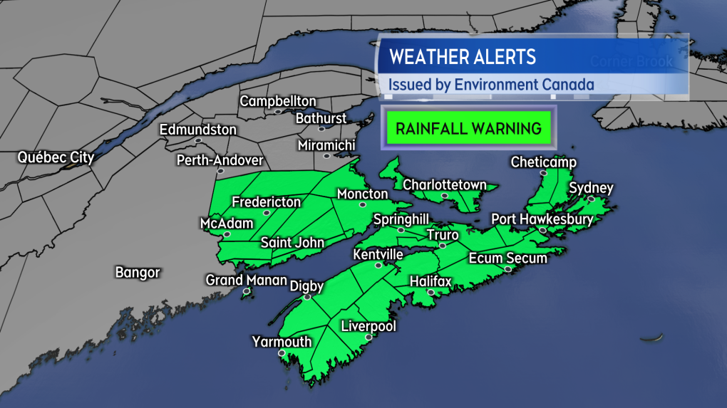 Rainfall warnings were issued by Environment Canada Friday morning.
The rain will start in southwestern Nova Scotia and New Brunswick late Friday evening. By early Saturday morning, rain will be falling across the Maritimes.
Downpours will be present within the rain, reducing visibility and increasing the risk of hydroplaning conditions on the roads. The downpours will also contribute to some rainfall amounts reaching or exceeding 50 millimetres, which is the criteria for a rainfall warning. That is most likely for central and southern New Brunswick, Prince Edward Island, and Nova Scotia. In preparation for the rain, residents should consider checking property drainage to ensure it is clear of debris.
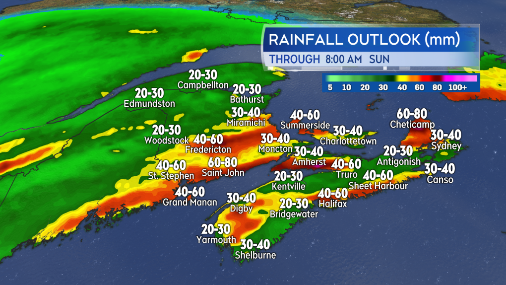 A widespread 20 to 40 mm on Saturday with some areas possibly reaching 50 to 80 mm as a result of downpours.
Wind will be a factor with the storm as well. Gusts peaking 60 to 80 kilometres per hour are expected for coastal areas of New Brunswick, Nova Scotia, and P.E.I. Gusts are expected to reach and exceed 100 kilometres per hour for northern Inverness County in Cape Breton due to the topography of the Highlands.
The highest winds mostly out of the south, except out of the northeast for the Acadian coastline of New Brunswick.
While these type of winds are typical with an autumn storm, there may be weakened trees and infrastructure left from storm Fiona. This may elevate the risk of power outages beyond what would be typically expected with a storm of this strength.
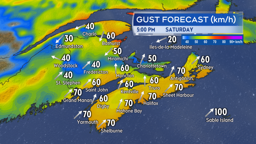 A snapshot of wind gusts for Saturday afternoon. Peak gusts of 60 to 80 km/h expected for coastal New Brunswick, Nova Scotia, and Prince Edward Island.
There is minimal risk of storm surge and coastal flooding with the storm. One area of concern that the Canadian Hurricane Centre notes is a risk of minor flooding affecting northeastern New Brunswick and the Gaspe region. Some extra caution is warranted for those coastal areas during the morning and evening high tides on Saturday.
Vessels operating in marine areas should check a detailed marine forecast. The passing storm is expected to elevate wave height to three to five metres and produce gale-to-storm force nautical winds.
 Rough surf and an onshore wind will be present for some of the coasts. Be cautious if around the coast particularly near high tide times on Saturday.
The rain will end for western areas of the Maritimes late Saturday afternoon into early evening. The rain ending for eastern areas of the Maritimes Saturday evening and night. Wind will diminish Saturday night into Sunday morning.
Shopping Trends
The Shopping Trends team is independent of the journalists at CTV News. We may earn a commission when you use our links to shop. Read about us.


CTVNews.ca Top Stories

Poilievre writes to GG calling for House recall, confidence vote after Singh declares he's ready to bring Liberals down
Conservative Leader Pierre Poilievre has written to Gov. Gen. Mary Simon, imploring her to 'use your authority to inform the prime minister that he must' recall the House of Commons so a non-confidence vote can be held. This move comes in light of NDP Leader Jagmeet Singh publishing a letter stating his caucus 'will vote to bring this government down' sometime in 2025.
At least 2 dead and 60 hurt after a car drives into a German Christmas market in a suspected attack
A car plowed into a busy outdoor Christmas market in the eastern German city of Magdeburg on Friday, killing at least two people and injuring at least 60 others in what authorities suspect was an attack.
16-year-old German exchange student dies after North Vancouver crash
A 16-year-old high school student from Germany who was hit by a Jeep in North Vancouver, B.C., last weekend has died in hospital, authorities confirmed.
Judge sentences Quebecer convicted of triple murder who shows 'no remorse'
A Quebecer convicted in a triple murder on Montreal's South Shore has been sentenced to life in prison without chance of parole for 20 years in the second-degree death of Synthia Bussieres.
Poilievre to Trump: 'Canada will never be the 51st state'
Conservative leader Pierre Poilievre is responding to U.S. president-elect Donald Trump’s ongoing suggestions that Canada become the 51st state, saying it will 'never happen.'
Canadiens executive says he has 'no concern' about members of the front office traveling to Russia
Montreal executive vice president of hockey operations Jeff Gorton said he has “no concern” about members of the Canadiens’ front office travelling to Russia with the country’s war in Ukraine ongoing.
Kelly Clarkson's subtle yet satisfying message to anyone single this Christmas
The singer and daytime-talk show host released a fireside video to accompany her 2021 holiday album, “When Christmas Comes Around” that she dubbed, “When Christmas Comes Around…Again.
School custodian stages surprise for Kitchener, Ont. students ahead of holiday break
He’s no Elf on the Shelf, but maybe closer to Ward of the Board.
Speeding drivers get holiday surprise from 'Officer Grinch'
Drivers in the Florida Keys who exceed the speed limit in school zones may run into a well-known gloomy green creature and get a surprising 'gift.'
Toronto
-

'Enough is enough': Toronto Jewish school struck by gunfire for third time since May
A Jewish elementary school in Toronto has been struck by gunfire for the third time in the last seven months.
-
6 arrested, 5 remain at large in auto theft ring that operated around Toronto Pearson Airport: police
Peel police have arrested six people and issued arrest warrants for five more suspects who are allegedly part of a Quebec theft ring responsible for stealing more than 100 vehicles in and around Toronto Pearson International Airport.
-
Police say break-and-enter suspects were in Canada for 'purpose of committing criminal offences'
Five Chilean nationals who police believe were in Canada for 'the purpose of committing criminal offences' have been charged in connection with half a dozen break-and-enters across the Greater Toronto Area (GTA).
Calgary
-

Calgary non-profit Yes Youth Centre hands out hundreds of free turkeys in Forest Lawn
Turkeys were flying out the door at the “Yes Youth Centre” in Forest Lawn Friday morning.
-
3 people sent to hospital after serious crash on Deerfoot Trail
A serious crash on Deerfoot Trail sent three people to hospital, including one in potentially life-threatening condition, on Friday afternoon.
-
Calgary man arrested in connection with more than a dozen robberies
Police say charges have been laid against a 19-year-old man in connection with a series of robberies that targeted cannabis and convenience stores in Calgary and Edmonton.
Edmonton
-

Second inmate dies at Edmonton Remand Centre in as many days
An inmate died at the Edmonton Remand Centre on Thursday night.
-
Child pornography charges laid against 52-year-old woman
A Sherwood Park woman has been charged with two child pornography offences.
-
'Proof will be in the pudding': Alberta changing how social agencies are funded
Alberta is looking to cut out the middleman when it comes to how social agencies are funded. On Friday, the province announced incoming changes to how services for Alberta's homeless population are funded.
Montreal
-

Judge sentences Quebecer convicted of triple murder who shows 'no remorse'
A Quebecer convicted in a triple murder on Montreal's South Shore has been sentenced to life in prison without chance of parole for 20 years in the second-degree death of Synthia Bussieres.
-
Manhunt underway after woman, 23, allegedly kidnapped, found alive in river
A woman in her 20s who was possibly abducted by her ex is in hospital after the car she was in plunged into the Richelieu River.
-
Canadiens executive says he has 'no concern' about members of the front office traveling to Russia
Montreal executive vice president of hockey operations Jeff Gorton said he has “no concern” about members of the Canadiens’ front office travelling to Russia with the country’s war in Ukraine ongoing.
Ottawa
-

Restaurants still waiting to see if GST/HST holiday impacts business
Reviews are beginning to come in from customers and restaurants a few days into the federal government's GST/HST holiday.
-
Man allegedly filming females in public washroom in business on Elgin Street, police looking for more victims
The Ottawa Police Service says a man has been arrested following a report alleging he was filming women inside a public washroom in a business on Elgin Street last weekend.
-
CTV and Move 100 Toy Mountain campaign raises $201,000
It will be a merry Christmas for 23,000 children in Ottawa this year, thanks to the community's generosity.
London
-

Man dies after falling from building: LPS
London police say a man has died after falling from a building.
-
Fire destroys London Cricket Club memorabilia, equipment
A fire destroyed thousands of dollars worth of property and memorabilia at the London Cricket Club.
-
'I don't have any challenges here at all': Tenants now occupying supportive housing building in south-central London
A London project that benefited from a federal government housing accelerator fund now has tenants.
Barrie
-

Multi-vehicle collision on Highway 11 in Oro-Medonte
Southbound traffic along Highway 11 through Oro-Medonte was brought to a crawl Friday after a multi-vehicle collision.
-
High school teacher charged with sexual assault amid allegations involving a student
A 51-year-old teacher from Georgina has been charged with sexual assault following allegations involving a student.
-
Driver charged after vehicle crashes into Barrie home
A driver was arrested Thursday night after a vehicle crashed into a home in Barrie.
Northern Ontario
-

Problems at Extendicare Countryside in Sudbury must be fixed before taking in new residents
Extendicare Countryside in Greater Sudbury was ordered Dec. 16 by the province not to take in new residents.
-
Northern Ont. police investigate child luring attempt
Police are looking for an older man who tried to lure a child to get into his vehicle Friday in Sturgeon Falls, Ont.
-
Northern Ont. man illegally killed three moose, one deer
A man from the northwestern Ontario community of Dinorwic has been found guilty of multiple hunting offences and fined $6,500, banned from hunting for five years and placed on probation for 18 months.
Kitchener
-

Guelph man pleads guilty to fleeing fatal crash involving cyclist
A Guelph driver, who previously admitted to failing to stop after a fatal crash, instead plead guilty to a different charge on Friday.
-
School custodian stages surprise for Kitchener, Ont. students ahead of holiday break
He’s no Elf on the Shelf, but maybe closer to Ward of the Board.
-
Distillers not feeling the 'tax holiday' spirit
While some shoppers and store owners are celebrating the HST 'tax holiday' from the federal government, not all industries are feeling the holiday spirit.
Windsor
-

Clear Medical Imaging strike ends with arbitration agreement
The eight-week long strike action at Clear Medical Imaging has ended. According to officials, Unifor and the employer have agreed to binding arbitration.
-
Over $45,000 in cash and drugs seized: WPS
Two suspects have been arrested and over $45,000 in cash and drugs seized following an investigation by the Windsor Police Service (WPS).
-
Who remembers the Elmwood Casino in Windsor?
A former employee is organizing a reunion on the 50th anniversary of the closing of the beloved and much celebrated nightclub and casino on Dougall Avenue.
Winnipeg
-

Bail denied for Winnipeg woman accused of killing animals in online videos
Warning: This story contains disturbing details. Discretion is advised. A Winnipeg woman accused of making videos of animals being tortured and killed that were sold on the dark web was denied bail.
-
Man suffers broken leg after being arrested by Winnipeg police; IIU investigating
The Winnipeg Police Service said the Independent Investigation Unit of Manitoba is investigating after a man suffered broken bones in his leg after being arrested.
-
'Good deals for Christmas': Turkey prices down from last year
With just days to go before Christmas, one of the big items for the big feast could be cheaper this year. Numbers from Agriculture and Agri-Food Canada show that during November this year, turkey prices were down from the same time last year.
Regina
-

'A sense of holiday spirit': Local shelter hosts Regina’s most vulnerable at annual Christmas dinner
For nearly 35 years, Souls Harbour Rescue Mission has been serving an annual Christmas dinner to Regina’s most vulnerable.
-
Drivers encouraged to check Highway Hotline before holiday travel
After receiving another big dump of snow over the past couple of days, Saskatchewan drivers have had to contend with some treacherous driving conditions.
-
Regina man creates snow sculpture to spread joy and inspire donations
A Regina man created a snow sculpture of a Santa head to spread joy and inspire donations to Big Brothers Big Sisters.
Saskatoon
-

Sask. lawyers defend judge for staying fatal THC-impaired driving charge
The Saskatchewan Trial Lawyers Association is defending a provincial court judge, who’s facing backlash for staying a charge in a high-profile case involving the death of a child.
-
Saskatoon police release details about latest homicide
Saskatoon police are releasing new details about the city’s latest homicide, although no charges have yet been laid.
-
Search continues for man wanted in connection with all-day manhunt in northern Sask.
The Saskatchewan RCMP are still searching for 28-year-old Dallas Fulton, wanted in connection with a dangerous person alert sent out across the province in October.
Vancouver
-

UBC celebrates historic year in sports
University of British Columbia athletes had a lot to celebrate in 2024. From Olympic medals to winning several national titles and getting drafted to the professional ranks, the school had no shortage of achievements to celebrate.
-
16-year-old German exchange student dies after North Vancouver crash
A 16-year-old high school student from Germany who was hit by a Jeep in North Vancouver, B.C., last weekend has died in hospital, authorities confirmed.
-
B.C. man 'trying to appear cool' with loaded handgun at nightclub sentenced
A 23-year-old British Columbia man who pleaded guilty to carrying a loaded handgun inside a crowded nightclub has been sentenced to two-and-a-half years in prison.
Vancouver Island
-

B.C. man 'trying to appear cool' with loaded handgun at nightclub sentenced
A 23-year-old British Columbia man who pleaded guilty to carrying a loaded handgun inside a crowded nightclub has been sentenced to two-and-a-half years in prison.
-
Warrants issued for 'violent offenders' after Nanaimo jewelry store robbery
Authorities are asking for the public 's help finding two suspects wanted in connection with a Nanaimo, B.C., jewelry store robbery earlier this year.
-
B.C. teachers cultivate community through merry music videos
Although his classroom is filled with students now, Jeff Bordal will never forget how empty it once was.
Kelowna
-

Forfeited Hells Angels clubhouse in Kelowna, B.C., sold to the city
A former Hells Angels clubhouse that was seized by the British Columbia government in 2023 after years of fighting in court has been sold to the City of Kelowna.
-
Death of woman found in Kelowna's Waterfront Park in June deemed 'non-criminal in nature': RCMP
Police in Kelowna say a death they began investigating back in June has now been confirmed as "non-criminal in nature."
-
B.C. man sentenced for 'execution-style' murder of bystander in drug trade conflict
A B.C. man convicted of the "intentional and ruthless killing of a bystander" while acting as an enforcer in the drug trade has been sentenced for a second time in the slaying.


