Weather deja vu: Saturday storm system to mirror Wednesday’s snow, rain and wind
 A person braves the elements along the Emera Oval in Halifax on Jan. 10, 2024. (Carl Pomeroy/CTV Atlantic)
A large storm system that passed just the west of the Maritimes Wednesday brought a combination of snow, rain, and high winds.
According to the network of volunteer observers at CoCoRaHS Canada, the most snow fell in northern areas of New Brunswick, with some locations totalling between 16 and 25 cm.
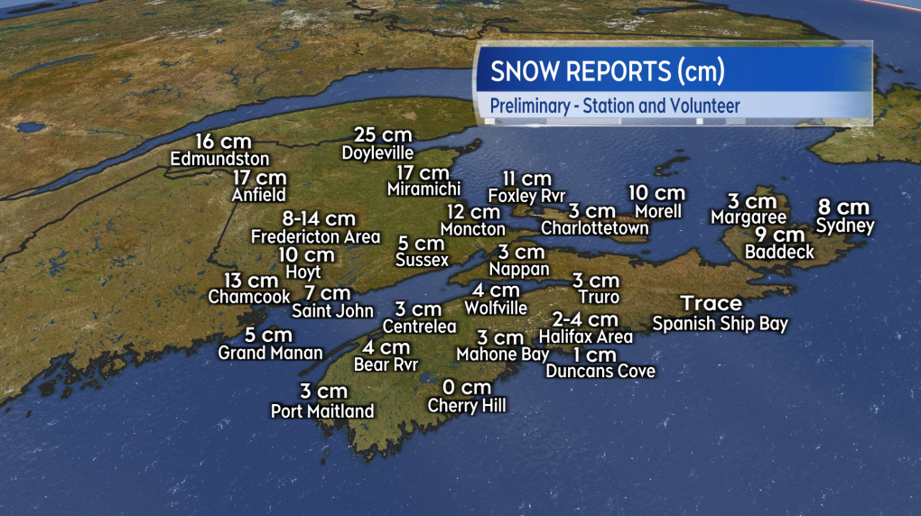 Snow reports from Wednesday.
The initial snow turned from ice pellets over to rain across most of the Maritimes, with the combination of precipitation bringing some totals of 20 to 40 mm.
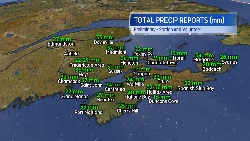 Total precipitation reports from Wednesday. This would include melt from snow and ice pellets as well as rain.
A high and gusty southeast wind accompanied the mix of precipitation. Peak winds gusts reach 80 to near 100 km/h around the Bay of Fundy coastline in New Brunswick, much of Nova Scotia, and much of Cape Breton. Due to the topography of the Cape Breton Highlands, fierce winds ripped through the area from St. Joseph du Moine to Cheticamp in Inverness County. Personal weather stations in the area clocked gusts of 140 to 170 km/h.
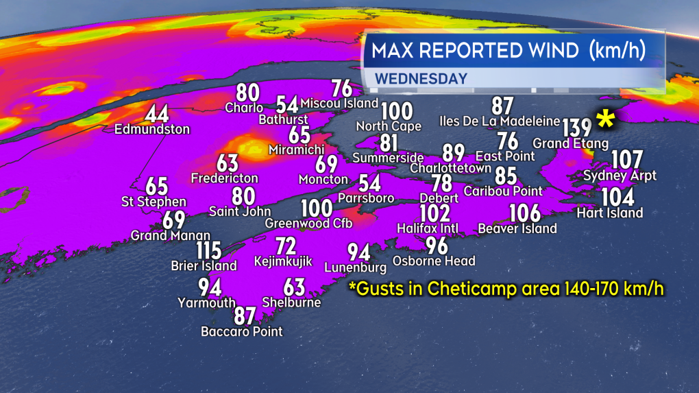 Peak wind gusts reported on Wednesday at weather stations across the region.
SATURDAY SYSTEM
A very similar storm system is expected to impact the Maritime region on Saturday. Once again, it will be a developing storm moving from near Texas towards southern Ontario and the northeastern United States. That track puts the Maritimes on the eastern side of the storm. A mix of snow and ice pellets turning to rain is expected for most of the region again.
Northern areas of New Brunswick will see the most snow with 10 to 20 cm possible. Central and western areas of New Brunswick should receive 5 to 10 cm, along with the Cape Breton Highlands. Much of the rest of the Maritimes looks likely to see 5 cm or less before a turn to rain. Nova Scotia and southwestern New Brunswick will see as much as 10 to 20 mm of rain. Watch for increased water runoff from the combination of rainfall and snow/ice melt. Sunday morning there is a risk of icy conditions as temperatures come back down towards freezing.
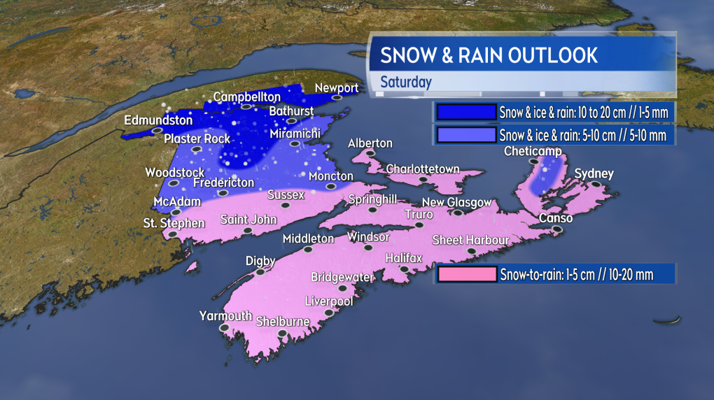 Another mix of snow turning over to rain is expected for the region on Saturday.
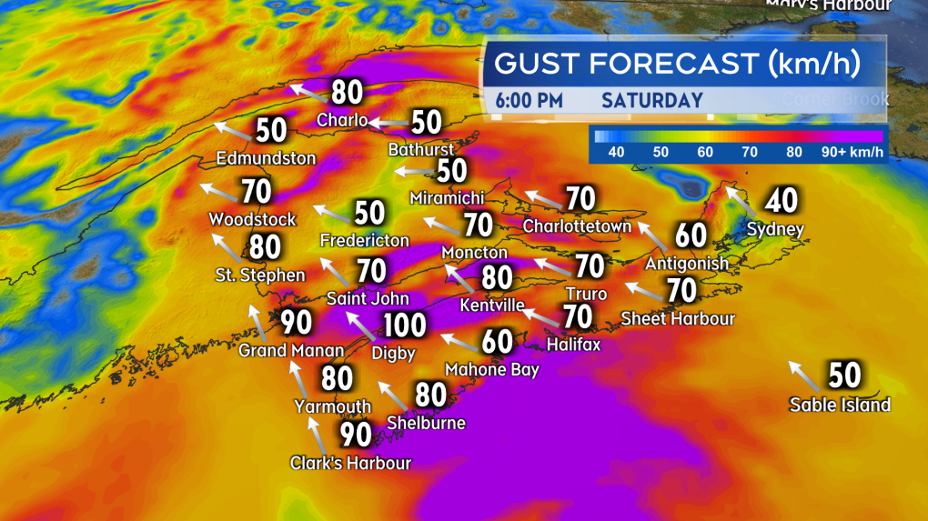
WATCH FOR WIND
The mix of precipitation will be accompanied by a high and gusty southeast wind. Widespread gusts will peak 50 to 70 km/h across the Maritimes Saturday afternoon and Saturday evening. Stronger gusts of 70 to 100 km/h are a risk for coastal New Brunswick, Nova Scotia, and Prince Edward Island. Due to the topography of the Highlands, northern Inverness County in Cape Breton could reach gusts of 130 km/h or higher.
 A bump up in temperature along with a strong southeast wind is also expected.
On Saturday, the wind will come with similar impacts as Wednesday. That includes a risk of scattered power outages, travel disruption, and a rough and pounding coastal surf. Due to crashing waves and the wind, water levels could reach above the typical mark during high tides on Saturday.
Special weather statements were issued by Environment Canada for the Maritime provinces at 4 p.m. on Thursday. The statements call for a storm “similar to the one which impacted the region on Wednesday, will affect the Maritime provinces this weekend.” Along with mixed precipitation and strong wind, they caution that tides will be near astronomical highs and that water levels could be elevated on parts of the coast. They advise the public to continue to monitor the forecast and any further alerts issued by the agency.
CTV meteorologist Kalin Mitchell will have updates, timelines, and regional weather conditions through the end of the week on CTV News Atlantic programming and at ctvnewsatlantic.ca.
Shopping Trends
The Shopping Trends team is independent of the journalists at CTV News. We may earn a commission when you use our links to shop. Read about us.


CTVNews.ca Top Stories

Justin Trudeau to step down as PM following Liberal leadership race
Prime Minister Justin Trudeau is stepping down as Liberal leader, and is proroguing Parliament as the Liberal Party of Canada embarks on the journey to replace him.
Trudeau resignation: recap key moments, analysis, reaction as it happened
Prime Minister Justin Trudeau has stepped down as Liberal leader. Here's a recap of key moments, analysis, and reaction as it happened.
Justin Trudeau steps down as Liberal leader. Who are the top contenders to replace him?
With Prime Minister Justin Trudeau's resignation as Liberal party leader, several well-known political faces may be waiting in the wings for their opportunity to take his place.
'Together, what a great nation it would be': Donald Trump, Elon Musk react to Justin Trudeau's resignation
Amid news of Prime Minister Justin Trudeau's resignation as leader of the Liberal party on Monday morning, reactions from prominent figures began piling in.
Trudeau says Parliament is 'prorogued' until March. What does that mean?
In his resignation speech on Monday, Prime Minister Justin Trudeau announced that Parliament would be prorogued until March, which will give the Liberal party time to find a new leader ahead of an expected confidence vote and early election.
Justin Trudeau is resigning, what will be his legacy? A look back at key political eras
In a seismic political move, Justin Trudeau has announced his intention to step down as leader of the Liberal Party of Canada and prime minister, once his successor is named. This decision comes after more than nine years in the country's top job and nearly 12 years at the helm of his party.
Justin Trudeau resignation: Here's what he said in Ottawa today
Prime Minister Justin Trudeau delivered a speech about his political future Monday morning outside Rideau Cottage in Ottawa. Here's the message he delivered to Canadians.
Alberta government signs new oil and gas agreement with Enbridge
The Alberta government has signed an agreement with Enbridge that Premier Danielle Smith says will increase exports of the province's heavy oil to the United States.
Trudeau leaves mixed global legacy as he exits during turbulent time, analysts say
Prime Minister Justin Trudeau will leave the world stage with a legacy of promoting feminist causes and focusing on Asia, along with criticism that Canada's actions fell short of the government's rhetoric.
Toronto
-

Doug Ford snaps back at Donald Trump's Canada taunts with offer to 'buy Alaska'
Ontario Premier Doug Ford has snapped back at Donald Trump’s frequent taunts about treating Canada as a U.S. state with a counterproposal: buying Alaska.
-
Toronto police officer injured in pursuit of robbery suspects in North York
A Toronto police officer sustained a minor injury to his lower leg during the pursuit of several robbery suspects in North York late Monday afternoon.
-
1 arrested after vacant church in Oakville allegedly intentionally set ablaze: police
A male is in police custody after allegedly intentionally setting a vacant church in Oakville on fire late Monday morning.
Calgary
-
Justin Trudeau to step down as PM following Liberal leadership race
Prime Minister Justin Trudeau is stepping down as Liberal leader, and is proroguing Parliament as the Liberal Party of Canada embarks on the journey to replace him.
-
Alberta government signs new oil and gas agreement with Enbridge
The Alberta government has signed an agreement with Enbridge that Premier Danielle Smith says will increase exports of the province's heavy oil to the United States.
-
Canadian oil stocks climb as industry absorbs news of Trudeau resignation
Canadian oil and gas stocks climbed Monday as the country's energy sector absorbed the news of Prime Minister Justin Trudeau's resignation.
Edmonton
-

Alberta faces potential short-term gain, long-term pain after Trudeau quits as prime minister
Justin Trudeau's resignation as Canada's prime minister and leader of the Liberal party should benefit the province in the short term, but long-term, the importance of free trade should be central to any Albertan or Canadian effort to sway U.S. opinion with the spectre of potentially crushing tariffs looming, pundits say.
-
Justin Trudeau to step down as PM following Liberal leadership race
Prime Minister Justin Trudeau is stepping down as Liberal leader, and is proroguing Parliament as the Liberal Party of Canada embarks on the journey to replace him.
-
'We're in an epidemic': Deaths of two women in alleged domestic abuse cases raising red flags
Advocates for domestic abuse survivors say the deaths of an Edmonton woman and a Calgary mother and her father over the holidays shows domestic abuse is an “epidemic.”
Montreal
-

'It was the right decision': Quebec politicians, residents react to Trudeau resignation
Elected officials in Quebec were quick to react to the major announcement in Ottawa Monday about Prime Minister Justin Trudeau and the path forward for the federal Liberal Party.
-
Man, 27, injured in possible stabbing in Plateau-Mont-Royal
A 27-year-old man was sent to hospital with serious injuries after a possible stabbing in broad daylight Monday afternoon.
-
Health authorities advise caution as flu season intensifies
Quebec's Health and Social Service Ministry says the influenza season is intensifying while cases of the common cold are stabilizing. However, the situation could change rapidly as students gradually return to school this week.
Ottawa
-

Ottawa mayor says prorogation of parliament gives city time to work with MPs on transit funding request
Ottawa Mayor Mark Sutcliffe says he remains optimistic that the City of Ottawa will eventually get the transit funding it has requested from the federal government, despite Monday's announcement by Prime Minister Justin Trudeau that Parliament has been prorogued and that he intends to step aside as Liberal leader and prime minister.
-
Ottawa's new north-south O-Train opens to the public
A large crowd gathered at Bayview Station just before 6 a.m. for a chance to be the first person to ride on the new north-south Line 2 Monday morning. The new north-south Line 2 and Line 4 runs from Bayview Station to Riverside South, with a link to the Ottawa International Airport.
-
Justin Trudeau to step down as PM following Liberal leadership race
Prime Minister Justin Trudeau is stepping down as Liberal leader, and is proroguing Parliament as the Liberal Party of Canada embarks on the journey to replace him.
London
-

Body found on Lake Erie shoreline prompts death investigation
Elgin County OPP are investigating after a deceased individual was discovered on the shoreline of Lake Erie in the township of Malahide.
-
Goderich Memorial Arena closed due to 'significant safety concerns'
At a standing room only meeting of Goderich’s Memorial Arena Task Force on Monday frustrated members of the public heard about council’s January 3 decision to close the arena until further notice.
-
Strangulation attack inside Sarnia church sparks security review
The incident happened Saturday inside the Adoration Chapel at Our Lady of Mercy Catholic Church - the chapel is available 24 hours a day for those who know the door code to enter.
Barrie
-

Former Snowbirds pilot charged with sexual assault testifies in Barrie court
A former Canadian Forces Snowbirds pilot accused of forcing himself on a colleague before last summer’s airshow in Barrie took the stand to clear his name in court on Monday.
-
Collision involving snowmobile at Hwy 12 crossing under investigation
Provincial police are investigating a collision involving a snowmobile in Midland.
-
Rookie driver charged with speeding over 2x posted limit: OPP
Provincial police say a G2 driver faces serious charges after being clocked speeding more than double the posted limit in the Town of New Tecumseth over the weekend.
Northern Ontario
-
Justin Trudeau to step down as PM following Liberal leadership race
Prime Minister Justin Trudeau is stepping down as Liberal leader, and is proroguing Parliament as the Liberal Party of Canada embarks on the journey to replace him.
-
Two Greater Sudbury drivers charged in racing incident on Hwy. 69
Ontario Provincial Police stopped to vehicles travelling more than double the speed limit on Highway 69 south of Greater Sudbury, early Friday morning.
-
Province boosts Sudbury's annual funding by $2.7M
The City of Greater Sudbury is one of more than 300 municipalities receiving an increase to their annual provincial funding this year.
Kitchener
-

Uncertainty surrounds college semester in Ontario as strike deadline looms
Students at Ontario’s 24 public colleges are beginning their winter semester under the cloud of a potential strike.
-
Social media famous corgi from Kitchener, Ont. rescues owner
A captivating canine is being hailed as a hero after one of his owners took a terrifying fall.
-
Justin Trudeau to step down as PM following Liberal leadership race
Prime Minister Justin Trudeau is stepping down as Liberal leader, and is proroguing Parliament as the Liberal Party of Canada embarks on the journey to replace him.
Windsor
-

'It is a nice piece of history': remnants of possible 19th century schooner shipwreck wash up in Erieau
Former Erieau harbourmaster Jeff Vidler hopes to salvage and preserve the large section of the vessel, believing it to be from a wooden schooner that was likely built in the 1850's.
-
Three gunpoint robbery suspects sought, one arrested
Windsor police officers have arrested one suspect and they are looking for three others after an armed robbery on University Avenue.
-
Selfish? Strategic? Windsor-Essex MP’s weigh-in on Trudeau resignation
Prime Minister Justin Trudeau announced Monday he is proroguing Parliament and will resign once a new leader is elected to the Liberal Party of Canada.
Winnipeg
-

'Different life to the party': Manitoba weighs in on Trudeau’s resignation
Manitobans are reacting to Justin Trudeau’s resignation as Liberal leader and his decision to prorogue to Parliament until March to allow for a leadership race.
-
Injunction extended against protesters in Lemay Forest
A court-ordered injunction against a group protesting the clearing of a Winnipeg forest will remain in place.
-
Man charged with voyeurism at Winnipeg fitness facility
A 26-year-old man has been charged with voyeurism after he allegedly snapped photos of a child undressing in a change room at a Winnipeg fitness facility.
Regina
-

Trudeau's resignation could lead to changes for Sask/Ottawa relationship
Premier Scott Moe and the Saskatchewan Party will be losing its most prominent "opponent" in the coming months – with Prime Minister Justin Trudeau announcing he intends to step down pending a leadership race.
-
Sask. RCMP make arrest in suspicious death on Piapot First Nation
Saskatchewan RCMP have arrested and charged Robin Kaiswatum, 40, with second degree murder in connection to a death on Piapot First Nation.
-
Saskatchewan politicians react to Trudeau's resignation announcement
Following Prime Minister Justin Trudeau's resignation announcement on Monday, reaction from politicians around the world quickly began to circulate, including in Saskatchewan.
Saskatoon
-

Judge condemns murder trial delay, asks lawyers to 'turn around' and look at the public 'we serve'
A Saskatoon murder trial opened on Monday with the judge sharply criticizing the time it’s taken to get to trial.
-
These 90-year-old identical twins were born in a Saskatchewan barn, but grew to love the city
Rose Worona and Anne Skwarchuk were born in 1935 on a farm near Hafford. Now, they’re celebrating their 90th birthday together.
-
Province calling for prospective builders on new Sask. Polytech campus in Saskatoon
The province is putting out the call to prospective builders for a major project on the new Saskatchewan Polytechnic campus planned in Saskatoon.
Vancouver
-

Concern grows as sea lion repeatedly wanders onto Vancouver Island highway
The first time a California sea lion was spotted in the middle of Highway 4, between Port Alberni and Ucluelet on Dec. 29, it was a curiosity.
-
Hidden in plain sight: Human trafficking and the B.C. connection
You may not see it or even know it’s happening in your community. But it is an evil shrouded in the dark shadows of society, and even experts do not know its full scope.
-
Justin Trudeau to step down as PM following Liberal leadership race
Prime Minister Justin Trudeau is stepping down as Liberal leader, and is proroguing Parliament as the Liberal Party of Canada embarks on the journey to replace him.
Vancouver Island
-

CBSA says it acted in 'good faith' detaining solar panels in forced labour probe
The Canada Border Services Agency says it acted lawfully and in "good faith" when it detained nearly 50 containers of solar panels belonging to a Victoria, B.C., company over concerns they were made using forced labour.
-
Victoria police cleared of wrongdoing in crash that killed 24-year-old taxi driver
British Columbia's police oversight agency has cleared Victoria police officers of wrongdoing after an attempted traffic stop on a city street led to the death of an innocent man last year.
-
Hidden in plain sight: Human trafficking and the B.C. connection
You may not see it or even know it’s happening in your community. But it is an evil shrouded in the dark shadows of society, and even experts do not know its full scope.
Kelowna
-

Lost skiers rescued off B.C. mountain
Search and rescue volunteers in B.C.’s Okanagan successfully reunited two skiers with their family Friday evening.
-
Charges laid after child porn investigation that 'spanned several different countries,' Kelowna RCMP say
Police in Kelowna say an international investigation has led to child pornography charges against a 46-year-old man.
-
Mounties investigate discovery of 'very small pipe bomb' in Kamloops, B.C.
Mounties are investigating and appealing for witnesses after an explosive device was discovered Wednesday on a beach in Kamloops, B.C.


