Weather warnings issued in the Maritimes ahead of Thursday snow
Environment Canada has issued snowfall warnings ahead of heavy snow forecast for Thursday.
The snow is a result of two low-pressure systems coming together, one out of the U.S. Midwest and the second out of Texas. The combined weather system will pass to the south of the Maritimes late Thursday into Friday bringing the region inclement weather.
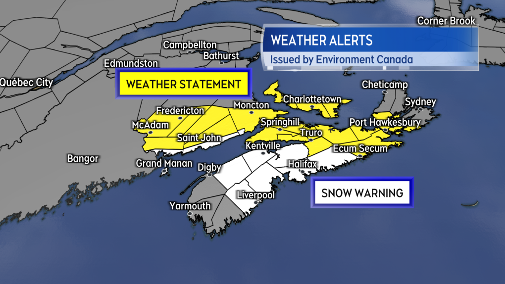 A combination of snowfall warnings and special weather statements are now in effect for the Maritimes.
In New Brunswick, the warnings are in effect for Grand Manan and Coastal Charlotte County as well as Saint John and the Bay of Fundy coastline. The warnings call for 15 to 20 cm of snow Thursday noon through Thursday night.
A special weather statement calling for 10 to 15 cm of snow remains in effect for central and southeastern New Brunswick.
Snowfall warnings are in place for the Annapolis Valley of Nova Scotia as well as Queens County through eastern Halifax County. A widespread 15 to 25 cm snowfall is expected there from Thursday afternoon through Friday morning.
Special weather statements continue for Cumberland/Colchester, the North Shore, the Eastern Shore, and southern Inverness as well as Richmond counties Cape Breton. The statements say that the snow may not start until Thursday evening but totals of 15 to 20 cm are still possible.
There are no alerts in effect for the Tri-county area of Digby, Yarmouth, and Shelburne. That southwestern area is expected to see rain mix with the snow reducing total accumulation.
A Special weather statement continues for Prince Edward Island. Five to 10 cm of snow is forecast for the province with a chance the southern coastline could see totals of up to 15 cm.
Environment Canada notes in both the warning and statements that driving conditions will deteriorate Thursday evening and night, with weather conditions improving Friday morning.
 The most snow is still expected to range from parts of southern New Brunswick and then across much of mainland Nova Scotia.
An easterly wind turning northerly will accompany the falling snow. Gusts may reach 30 to 50 km/h Thursday night into early Friday morning. Gusts on the Atlantic coastline of Nova Scotia peaking 50 to 70 km/h.
While below warning criteria the wind gusts are likely to combine with the falling snow reducing visibility for periods of time. Reduced visibility is most likely in southern New Brunswick and mainland Nova Scotia Thursday evening and night as heavier snow is expected during that time.
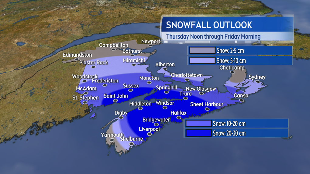 Snow starts in the west of the region near noon on Thursday. By evening the snow will be more widespread and increasing in intensity.
Updates along with snow and wind timelines on CTV News Atlantic programming 5, 6, and 11:30 PM.
Shopping Trends
The Shopping Trends team is independent of the journalists at CTV News. We may earn a commission when you use our links to shop. Read about us.


CTVNews.ca Top Stories

BREAKING
BREAKING 'Canadians deserve a real choice': Justin Trudeau resigning, prorogues Parliament
Prime Minister Justin Trudeau is stepping down as Liberal leader, and is proroguing Parliament as the Liberal Party of Canada embarks on the journey to replace him.
WATCH LIVE
WATCH LIVE Justin Trudeau resigns as Liberal leader: Follow live updates
Prime Minister Justin Trudeau has stepped down as Liberal leader. Follow along for live updates from CTVNews.ca.
'Together, what a great nation it would be': Donald Trump, Elon Musk react to Justin Trudeau's resignation
Amid news of Prime Minister Justin Trudeau's resignation as leader of the Liberal party on Monday morning, reactions from prominent figures began piling in.
Justin Trudeau is resigning, what will be his legacy? A look back at key political eras
In a seismic political move, Justin Trudeau has announced his intention to step down as leader of the Liberal Party of Canada and prime minister, once his successor is named. This decision comes after more than nine years in the country's top job and nearly 12 years at the helm of his party.
Justin Trudeau resignation: Here's what he said in Ottawa today
Prime Minister Justin Trudeau delivered a speech about his political future Monday morning outside Rideau Cottage in Ottawa. Here's the message he delivered to Canadians.
Alberta government signs new oil and gas agreement with Enbridge
The Alberta government has signed an agreement with Enbridge that Premier Danielle Smith says will increase exports of the province's heavy oil to the United States.
Judge condemns murder trial delay, asks lawyers to 'turn around' and look at the public 'we serve'
A Saskatoon murder trial opened on Monday with the judge sharply criticizing the time it’s taken to get to trial.
Doug Ford snaps back at Donald Trump's Canada taunts with offer to 'buy Alaska'
Ontario Premier Doug Ford has snapped back at Donald Trump’s frequent taunts about treating Canada as a U.S. state with a counterproposal: buying Alaska.
Canadian alleged drug lord Ryan Wedding still has access to 'network of hitmen': U.S. prosecutors
U.S. prosecutors are seeking additional protections to keep the identities of confidential informants and co-operating witnesses hidden in the case against Ryan James Wedding, as the search continues for the Canadian ex-Olympian and alleged drug lord.
Toronto
-
BREAKING
BREAKING 'Canadians deserve a real choice': Justin Trudeau resigning, prorogues Parliament
Prime Minister Justin Trudeau is stepping down as Liberal leader, and is proroguing Parliament as the Liberal Party of Canada embarks on the journey to replace him.
-
Doug Ford snaps back at Donald Trump's Canada taunts with offer to 'buy Alaska'
Ontario Premier Doug Ford has snapped back at Donald Trump’s frequent taunts about treating Canada as a U.S. state with a counterproposal: buying Alaska.
-
Canadian alleged drug lord Ryan Wedding still has access to 'network of hitmen': U.S. prosecutors
U.S. prosecutors are seeking additional protections to keep the identities of confidential informants and co-operating witnesses hidden in the case against Ryan James Wedding, as the search continues for the Canadian ex-Olympian and alleged drug lord.
Calgary
-
BREAKING
BREAKING 'Canadians deserve a real choice': Justin Trudeau resigning, prorogues Parliament
Prime Minister Justin Trudeau is stepping down as Liberal leader, and is proroguing Parliament as the Liberal Party of Canada embarks on the journey to replace him.
-
Alberta government signs new oil and gas agreement with Enbridge
The Alberta government has signed an agreement with Enbridge that Premier Danielle Smith says will increase exports of the province's heavy oil to the United States.
-
Canadian oil stocks climb as industry absorbs news of Trudeau resignation
Canadian oil and gas stocks climbed Monday as the country's energy sector absorbed the news of Prime Minister Justin Trudeau's resignation.
Edmonton
-
BREAKING
BREAKING 'Canadians deserve a real choice': Justin Trudeau resigning, prorogues Parliament
Prime Minister Justin Trudeau is stepping down as Liberal leader, and is proroguing Parliament as the Liberal Party of Canada embarks on the journey to replace him.
-
Teen charged in stabbing at Alberta recreation centre
A teen boy has been charged after a stabbing at a northern Alberta recreation centre.
-
Large, slow-moving load to cause delays between Edmonton and Fort McMurray
A large, heavy load will travel between Edmonton and Fort McMurray starting on Tuesday.
Montreal
-

'It was the right decision': Quebec politicians react to Trudeau resignation
Elected officials in Quebec were quick to react to the major announcement in Ottawa Monday about Prime Minister Justin Trudeau and the path forward for the federal Liberal Party.
-
Man, 27, injured in possible stabbing in Plateau-Mont-Royal
A 27-year-old man was sent to hospital with serious injuries after a possible stabbing in broad daylight Monday afternoon.
-
One dead after head-on collision on Highway 40 East
Quebec provincial police (SQ) are investigating after a head-on collision left one person dead on Highway 40 eastbound on Monday morning.
Ottawa
-
BREAKING
BREAKING 'Canadians deserve a real choice': Justin Trudeau resigning, prorogues Parliament
Prime Minister Justin Trudeau is stepping down as Liberal leader, and is proroguing Parliament as the Liberal Party of Canada embarks on the journey to replace him.
-
Ottawa's new north-south O-Train opens to the public
A large crowd gathered at Bayview Station just before 6 a.m. for a chance to be the first person to ride on the new north-south Line 2 Monday morning. The new north-south Line 2 and Line 4 runs from Bayview Station to Riverside South, with a link to the Ottawa International Airport.
-
Meet the winners of the CHEO Dream of a Lifetime Lottery grand prize
Tracey Lavergne of Woodlawn, Ont. is starting off the new year with a new Minto Dream Home in Manotick, the grand prize in the CHEO Dream of a Lifetime Lottery.
London
-

Body found on Lake Erie shoreline prompts death investigation
Elgin County OPP are investigating after a deceased individual was discovered on the shoreline of Lake Erie in the township of Malahide.
-
Goderich arena closed due to 'significant safety concerns'
At a standing room only meeting of Goderich’s Memorial Arena Task Force on Monday frustrated members of the public heard about council’s January 3 decision to close the Memorial Arena until further notice.
-
BREAKING
BREAKING 'Canadians deserve a real choice': Justin Trudeau resigning, prorogues Parliament
Prime Minister Justin Trudeau is stepping down as Liberal leader, and is proroguing Parliament as the Liberal Party of Canada embarks on the journey to replace him.
Barrie
-

Border officers arrest man accused of smuggling banned firearms into Canada
A man from Aurora, Ont. is facing multiple weapons-related charges after Canadian Border Services Agency (CBSA) officers intercepted packages reportedly containing various prohibited firearms.
-
Rookie driver charged with speeding over 2x posted limit: OPP
Provincial police say a G2 driver faces serious charges after being clocked speeding more than double the posted limit in the Town of New Tecumseth over the weekend.
-
Newly licensed G driver charged with stunt driving after road test: OPP
Provincial police say a newly licensed motorist was “hot off the road test” on Sunday when an officer conducted a traffic stop.
Northern Ontario
-
BREAKING
BREAKING 'Canadians deserve a real choice': Justin Trudeau resigning, prorogues Parliament
Prime Minister Justin Trudeau is stepping down as Liberal leader, and is proroguing Parliament as the Liberal Party of Canada embarks on the journey to replace him.
-
Province boosts Sudbury's annual funding by $2.7M
The City of Greater Sudbury is one of more than 300 municipalities receiving an increase to their annual provincial funding this year.
-
Driver charged after asleep at the wheel complaint
A traffic complaint about a man asleep at the wheel at an intersection has resulted in impaired driving charges being laid against a northern Ontario man.
Kitchener
-

New threshold for reporting collisions in Ontario
Ontario has increased the threshold dictating when drivers are required to report a collision to police.
-
BREAKING
BREAKING 'Canadians deserve a real choice': Justin Trudeau resigning, prorogues Parliament
Prime Minister Justin Trudeau is stepping down as Liberal leader, and is proroguing Parliament as the Liberal Party of Canada embarks on the journey to replace him.
-
Canadian alleged drug lord Ryan Wedding still has access to 'network of hitmen': U.S. prosecutors
U.S. prosecutors are seeking additional protections to keep the identities of confidential informants and co-operating witnesses hidden in the case against Ryan James Wedding, as the search continues for the Canadian ex-Olympian and alleged drug lord.
Windsor
-

Three gunpoint robbery suspects sought, one arrested
Windsor police officers have arrested one suspect and they are looking for three others after an armed robbery on University Avenue.
-
St. Clair College students face uncertainty as strike deadline looms
St. Clair College students began their winter semester Monday under a cloud of uncertainty, with the threat of a faculty strike just days away.
-
'He won't be a John Doe anymore': OPP use new DNA testing to solve 21-year-old cold case
OPP have used new DNA technology to solve a 21-year-old cold case near Amherstburg, Ont. The new testing has led to the identification of the remains of a man found in 2003.
Winnipeg
-

Justin Trudeau is resigning, what will be his legacy? A look back at key political eras
In a seismic political move, Justin Trudeau has announced his intention to step down as leader of the Liberal Party of Canada and prime minister, once his successor is named. This decision comes after more than nine years in the country's top job and nearly 12 years at the helm of his party.
-
Man charged with voyeurism at Winnipeg fitness facility
A 26-year-old man has been charged with voyeurism after he allegedly snapped photos of a child undressing in a change room at a Winnipeg fitness facility.
-
'Absolutely devastating': Southern Manitoba golf course clubhouse burns for second time in 4 years
A golf course clubhouse in Morden, Man. went up in flames Sunday for the second time in less than four years, and mere days after its reopening from the previous fire was celebrated.
Regina
-

Saskatchewan politicians react to Trudeau's resignation announcement
Following Prime Minister Justin Trudeau’s resignation announcement on Monday, reaction from politicians around the world quickly began to circulate, including in Saskatchewan.
-
'Everything I've ever dreamed of': Regina Cougars curling to represent Canada at World University Games
The University of Regina Men's Curling team is preparing for the international stage as they gear up as Team Canada for the 2025 FISU Winter World University Games.
-
Annual FSIN volleyball tournament hosted in Regina continues to grow
Eighty-four youth volleyball players from 27 First Nations across Saskatchewan gathered over the weekend to compete in Regina at the annual FSIN Volleyball Championship.
Saskatoon
-

Judge condemns murder trial delay, asks lawyers to 'turn around' and look at the public 'we serve'
A Saskatoon murder trial opened on Monday with the judge sharply criticizing the time it’s taken to get to trial.
-
Province calling for prospective builders on new Sask. Polytech campus in Saskatoon
The province is putting out the call to prospective builders for a major project on the new Saskatchewan Polytechnic campus planned in Saskatoon.
-
Saskatoon police seek man in connection with weekend stabbing
Saskatoon police are asking the public for tips after a man was stabbed outside a 22nd Street business over the weekend.
Vancouver
-
BREAKING
BREAKING 'Canadians deserve a real choice': Justin Trudeau resigning, prorogues Parliament
Prime Minister Justin Trudeau is stepping down as Liberal leader, and is proroguing Parliament as the Liberal Party of Canada embarks on the journey to replace him.
-
Vancouver Canucks star defenceman Hughes a game-time decision vs. Montreal Canadiens
The injury-plagued Vancouver Canucks may get a crucial piece back in their lineup when they visit the Montreal Canadiens on Monday.
-
Victoria police cleared of wrongdoing in crash that killed 24-year-old taxi driver
British Columbia's police oversight agency has cleared Victoria police officers of wrongdoing after an attempted traffic stop on a city street led to the death of an innocent man last year.
Vancouver Island
-

Victoria police cleared of wrongdoing in crash that killed 24-year-old taxi driver
British Columbia's police oversight agency has cleared Victoria police officers of wrongdoing after an attempted traffic stop on a city street led to the death of an innocent man last year.
-
BREAKING
BREAKING 'Canadians deserve a real choice': Justin Trudeau resigning, prorogues Parliament
Prime Minister Justin Trudeau is stepping down as Liberal leader, and is proroguing Parliament as the Liberal Party of Canada embarks on the journey to replace him.
-
Mounties search for suspects after cash stolen from bank in Nanaimo, B.C.
Mounties are searching for two suspects who allegedly stole an undisclosed amount of cash from a bank on Vancouver Island.
Kelowna
-

Lost skiers rescued off B.C. mountain
Search and rescue volunteers in B.C.’s Okanagan successfully reunited two skiers with their family Friday evening.
-
Charges laid after child porn investigation that 'spanned several different countries,' Kelowna RCMP say
Police in Kelowna say an international investigation has led to child pornography charges against a 46-year-old man.
-
Mounties investigate discovery of 'very small pipe bomb' in Kamloops, B.C.
Mounties are investigating and appealing for witnesses after an explosive device was discovered Wednesday on a beach in Kamloops, B.C.


