Wicked, Wednesday wind on both west and east coasts of Canada
Strong Autumn weather systems drove fierce winds Tuesday into Wednesday on both the west and east coasts of the country. The wind resulted in power outages and travel disruptions.
Atlantic Canada squeeze
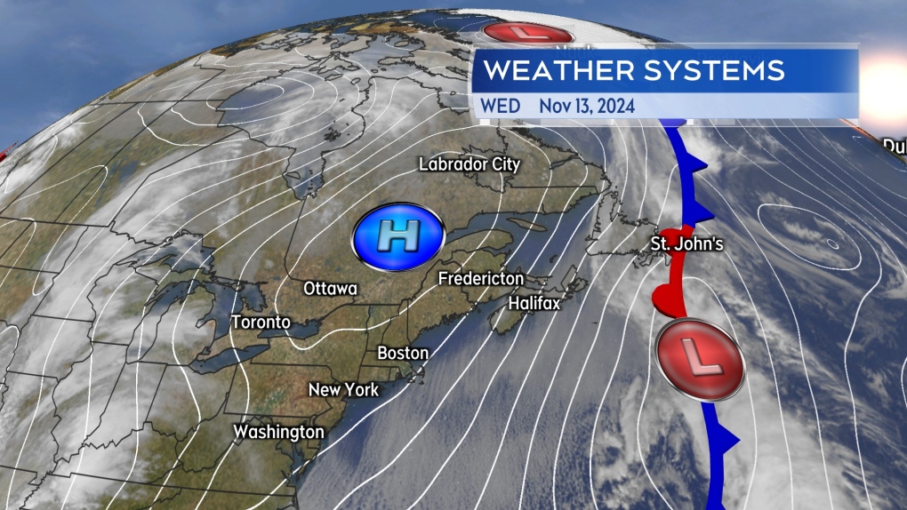
Areas of Atlantic Canada are contending with northerly gusts peaking as high as 70 to 100 km/h on Wednesday. The region is caught between a cold front to the east and a strong area of high pressure centred over Quebec. It is the pressure gradient between those two weather systems that is driving the strong and chilly wind.
 Squeezed between low pressure to the east and high pressure to the west, the wind was high and gusty in Atlantic Canada on Wednesday.
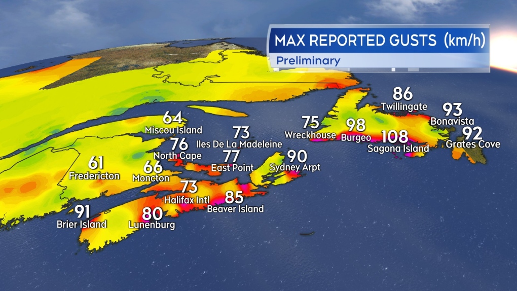
Wind warnings remain in effect for much of the south coast of Newfoundland, with gusts up to 100 km/h on parts of the coast. The Bonavista and Avalon Peninsulas remain under a rainfall warning with totals of 60 to 80 mm and 90 to 120 mm expected respectively. Power outages in the Maritimes as a result of the wind led to some school cancellations.
Ferry sailings between Nova Scotia and Newfoundland were cancelled on Wednesday. The Confederation Bridge, adjoining New Brunswick to Prince Edward Island, is restricting certain classes of vehicles from crossing.
 Preliminary peak wind gusts reported at select weather stations in Atlantic Canada as of 1 p.m. AST.
The high and gusty wind in the Atlantic Canada forecast will persist into Thursday. Wind speeds will diminish for Friday as the pressure gradient in the region is reduced as a stalled, low-pressure system backs into the Maritimes from the east.
British Columbia blast
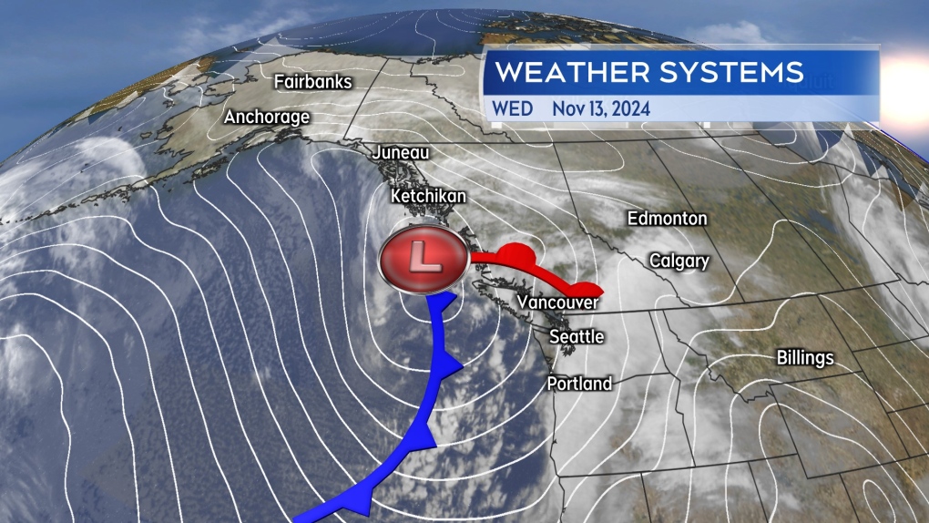
A strong low-pressure system rolled off the Pacific into the Haida Gwaii Islands of British Columbia Tuesday night into Wednesday morning.
 A Pacific storm produced a strong and disruptive wind all the way into south coastal areas Tuesday into Wednesday.
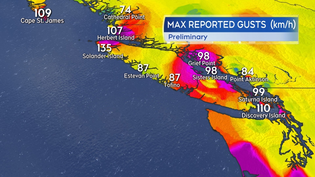
The storm produced wind gusts reaching and exceeding 100 km/h for coastal areas as far south as Discover Island, which sits just to the east of Victoria near the southernmost tip of Vancouver Island. Wind-related utility outages numbered into the tens-of-thousands and disrupted key ferry routes.
The wind is diminishing with peak gusts at 8 a.m. PST falling into a range of 50 to 75 km/h. The wind warnings issued on Tuesday by Environment Canada ending.
 Preliminary peak wind gusts recorded at select weather stations in B.C.
Rainfall warnings remain for some areas including Metro Vancouver, which is expecting rain totals of 50 to 90 mm. The storm will also go on to produce wintry conditions on Highway 3-Paulson Summit to Kootenay Pass with as much as 30 to 50 cm of snow expected. Environment Canada has that area under a winter storm warning that extends to Thursday night.
CTVNews.ca Top Stories

BREAKING Poilievre to submit letter to Governor General asking to recall House for confidence vote
Conservative Party Leader Pierre Poilievre announced that he will submit a letter to the Governor General asking to recall the House for a confidence vote.
'I understand there's going to be a short runway,' new minister says after Trudeau shuffles cabinet
Prime Minister Justin Trudeau added eight Liberal MPs to his front bench and reassigned four ministers in a cabinet shuffle in Ottawa on Friday, but as soon as they were sworn-in, they faced questions about the political future of their government, and their leader.
Quebecer convicted of killing partner, two children sentenced
A Quebecer convicted in a triple murder on Montreal's South Shore has been sentenced to life in prison without chance of parole for 20 years in the second-degree death of Synthia Bussieres.
A car has driven into a group of people at a Christmas market in Germany
A car drove into people at a Christmas market in the eastern German city of Magdeburg on Friday. Officials said they suspected it was an attack and that people were injured, but it was not immediately clear how many were harmed.
Poilievre to Trump: 'Canada will never be the 51st state'
Conservative leader Pierre Poilievre is responding to U.S. president-elect Donald Trump’s ongoing suggestions that Canada become the 51st state, saying it will 'never happen.'
Guelph man facing assault charge after police say he spat in roommate's face during disagreement over cat
A fight between roommates has led to an assault charge for a Guelph man.
Joss Stone says she's discovered she's pregnant – just weeks after adopting a baby
Joss Stone has revealed that she is pregnant, just weeks after she and her husband adopted a baby boy.
A new book about Chrystia Freeland just came out. Here's what we learned
A new book about Chrystia Freeland has just come out, after the publishing company sped up its release date by a few months. CTV News sifted through the book and pulled out some notable anecdotes, as well as insights about Freeland's relationship with the prime minister.
Police say break-and-enter suspects were in Canada for 'purpose of committing criminal offences'
Five Chilean nationals who police believe were in Canada for 'the purpose of committing criminal offences' have been charged in connection with half a dozen break-and-enters across the Greater Toronto Area (GTA).


