Wildfire areas soaked over the weekend, rainfall warnings in effect

A much needed rain fell over the weekend for much of the Maritimes, including those areas combating wildfires.
Through Monday morning, a large area of western Nova Scotia had received a general rainfall of 50 to 100 millimetres. Much of the remainder of the Maritimes with rain in a range of 20 to 50 millimitres. Further bands of rain continue to move into the region off the Atlantic as a low pressure system sits just to the south of Nova Scotia.
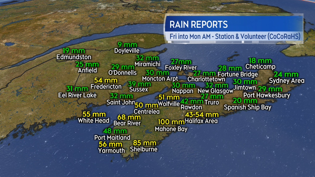 Station and volunteer reports of rain totals through Monday morning.
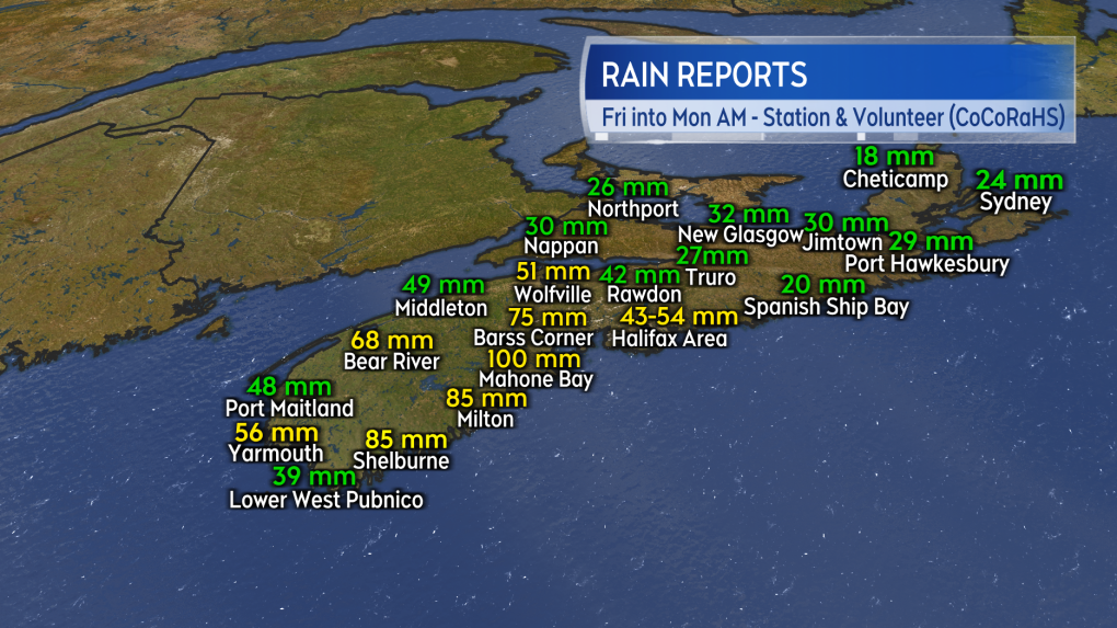 A closer look at reported rain totals into Monday morning for Nova Scotia.
Rainfall warnings are in effect for Halifax County and Guysborough County in Nova Scotia. The warnings call for totals of 60 to 90 millimetres by Tuesday evening. Environment Canada cautions that periods of heavier rain are possible and that “heavy downpours can cause flash floods and water pooling on roads. Localized flooding in low-lying areas is possible.”
A special weather statement is in effect for the remainder of Nova Scotia. As rain persists into Tuesday, three-day rain totals could amount to between 35 and 70 millimetres or more. Water may pool on roads and streams and creeks could swell quickly.
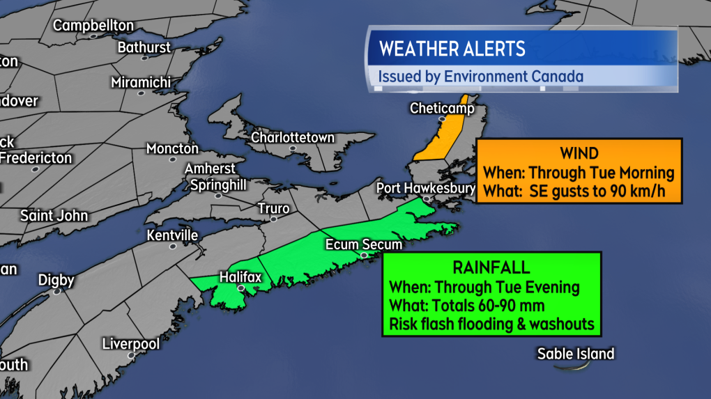 Rainfall warnings and a wind warning for portions of Nova Scotia.
Forecast guidance for the rain points to much of Nova Scotia, Prince Edward Island, and parts of eastern New Brunswick picking up the most additional amounts through Wednesday morning. That part of the Maritimes looks like it will have the best chance of see a further rainfall of 30, 40 or even 50 millimetres. While there are no weather alerts currently in effect for eastern New Brunswick or P.E.I., caution should be taken in steadier rain due to reduced visibility and hydroplaning conditions.
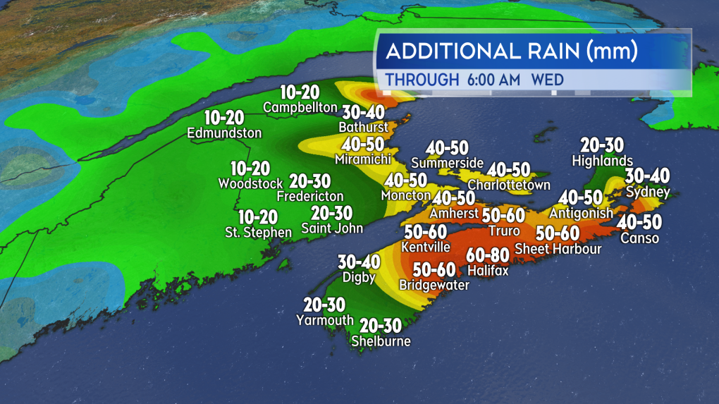 Forecast guidance shows a good chance of Nova Scotia, Prince Edward Island, and parts of eastern New Brunswick getting more steady, even heavy rain.The system begins to weaken Thursday and Friday. Despite that, cloudy skies and further periods of lighter showers and drizzle are still expected. Temperatures will be held well below averages for early June through Saturday.
The long range portion of the forecast does hint at the cloudy, damp, cool stretch of weather breaking for Sunday. That would allow for the sun to come through more and temperatures return closer to seasonable averages.


CTVNews.ca Top Stories

'They needed people inside Air Canada:' Police announce arrests in Pearson gold heist
Police say one former and one current employee of Air Canada are among the nine suspects that are facing charges in connection with the gold heist at Pearson International Airport last year.
House admonishes ArriveCan contractor in rare parliamentary show of power
MPs enacted an extraordinary, rarely used parliamentary power on Wednesday, summonsing an ArriveCan contractor to appear before the House of Commons where he was admonished publicly and forced to provide answers to the questions MPs said he'd previously evaded.
Leafs star Auston Matthews finishes season with 69 goals
Auston Matthews won't be joining the NHL's 70-goal club this season.
Trump lawyers say Stormy Daniels refused subpoena outside a Brooklyn bar, papers left 'at her feet'
Donald Trump's legal team says it tried serving Stormy Daniels a subpoena as she arrived for an event at a bar in Brooklyn last month, but the porn actor, who is expected to be a witness at the former president's criminal trial, refused to take it and walked away.
Why drivers in Eastern Canada could see big gas price spikes, and other Canadians won't
Drivers in Eastern Canada face a big increase in gas prices because of various factors, especially the higher cost of the summer blend, industry analysts say.
Doug Ford calls on Ontario Speaker to reverse Queen's Park keffiyeh ban
Ontario Premier Doug Ford is calling on Speaker Ted Arnott to reverse a ban on keffiyehs at Queen's Park, describing the move as “needlessly” divisive.
'A living nightmare': Winnipeg woman sentenced following campaign of harassment against man after online date
A Winnipeg woman was sentenced to house arrest after a single date with a man she met online culminated in her harassing him for years, and spurred false allegations which resulted in the innocent man being arrested three times.
Woman who pressured boyfriend to kill his ex in 2000s granted absences from prison
A woman who pressured her boyfriend into killing his teenage ex more than a decade ago will be allowed to leave prison for weeks at a time.
Customers disappointed after email listing $60K Tim Hortons prize sent in error
Several Tim Horton’s customers are feeling great disappointment after being told by the company that an email stating they won a boat worth nearly $60,000 was sent in error.
Shopping Trends
The Shopping Trends team is independent of the journalists at CTV News. We may earn a commission when you use our links to shop. Read about us.


Toronto
-

Doug Ford calls on Ontario Speaker to reverse Queen's Park keffiyeh ban
Ontario Premier Doug Ford is calling on Speaker Ted Arnott to reverse a ban on keffiyehs at Queen's Park, describing the move as “needlessly” divisive.
-
'They needed people inside Air Canada:' Police announce arrests in Pearson gold heist
Police say one former and one current employee of Air Canada are among the nine suspects that are facing charges in connection with the gold heist at Pearson International Airport last year.
-
Leafs star Auston Matthews finishes season with 69 goals
Auston Matthews won't be joining the NHL's 70-goal club this season.
Calgary
-

Arrest made, manslaughter charge pending in 2022 death of Calgary toddler
Calgary police have arrested a man and a charge is pending in connection with the death of a toddler in 2022.
-
'Blue Sky City': Calgary unveils new brand
Calgary has a new brand and it's looking up.
-
Ranchers 'vindicated' but concerned after court forces government to share coal policy documents
It took four years in court, but a group of Eastern Slope ranchers will finally get access to thousands of pages of documents outlining when and how the province decided to tear up 44 years of coal policy.
Edmonton
-

More than 150 people reported crashes in Edmonton Wednesday
More than 150 people have reported vehicle crashes in Edmonton on Wednesday.
-
Oilers a fitting opponent for what could be Coyotes' last game in Arizona
In at least a couple of ways, it's fitting the Edmonton Oilers will be the Arizona Coyotes' final opponent before the Desert Dogs shed their Kachina-styled uniforms for whatever hues and themes may await them in Salt Lake City.
-
Spring snow stalls golfers but moisture welcomed by courses and fire crews
While snow and ice aren't ideal weather for hitting the links, a local golf course said it's happy to see some April precipitation.
Montreal
-

Legault still doesn't know the price of a 4 1/2 in Montreal
François Legault still doesn't know the price of a 4 1/2 apartment in Montreal, three years after getting bogged down on the issue.
-
Quebec says education ministry presentation for parents could have been in English after all
In the latest example of the confusion surrounding Quebec's new language law, the education ministry has confirmed that a presentation delivered only in French to English-speaking parents last week could have been done in English after all.
-
Montreal police open fire on driver in suspected stolen vehicle intervention
Quebec's police watchdog has opened an investigation into a Montreal police (SPVM) intervention in the Côte-des-Neiges–Notre-Dame-de-Grâce borough that ended with one person seriously injured.
Ottawa
-
 GAS PRICES
GAS PRICES Ottawa gas prices expected to increase 14 cents a litre on Thursday
Ottawa motorists are being warned to expect a big hike in gasoline prices this week, as prices rise to the highest level since August 2022.
-
'We'd like to see it move faster': The push to increase activity in downtown Ottawa
Talk of transitioning federal buildings into housing has been in the works for a couple of years and it's a move that business leaders in Ottawa say can't come soon enough.
-
Customers disappointed after email listing $60K Tim Hortons prize sent in error
Several Tim Horton’s customers are feeling great disappointment after being told by the company that an email stating they won a boat worth nearly $60,000 was sent in error.
London
-

'Everyone is devastated': Hockey community mourns loss of young leader
The hockey community in Chatham-Kent and beyond is mourning the sudden death of a player caught in a highway crash this week in London.
-
New smart washroom the talk of Grand Bend
It’s not every day that a new washroom becomes the talk of the town. But in the Lake Huron tourist community of Grand Bend a new so-called smart washroom has many residents and business owners flush with joy.
-
Western named 'academic partner' by Canadian Nuclear Isotope Council
The Canadian Nuclear Isotope Council has named Western University an academic partner.
Barrie
-

Death investigation launched after body washes onto Lake Couchiching shore
Provincial police are investigating after a man's body washed up on the shores of Lake Couchiching in Severn Township.
-
Tim Hortons Roll Up The Rim contest faces backlash amid another ‘technical error’
Tim Hortons Roll Up The Rim contest may be in hot water yet again after several customers received emails falsely congratulating them on winning the Tracker boat worth nearly $60,000.
-
Multi-vehicle collision involving a semi-truck halts traffic
A multi-vehicle collision involving a semi-truck snarled traffic in Barrie on Wednesday afternoon.
Northern Ontario
-

$200M arena decision ‘a big step’ for Sudbury’s future, mayor says
In a lengthy council meeting Tuesday night, city council in Sudbury unanimously voted to build a new arena and events centre downtown.
-
Sudbury murder suspect talked about his role in ‘his girl’ getting hurt, witness testifies
A former girlfriend of a murder suspect in Sudbury testified Wednesday that he talked about his role in the deaths a day after a firebombing that killed three people.
-
Body of missing man found, northern Ontario police say
The body of a missing man has been found after his vehicle was pulled into a northern creek on Saturday morning, Ontario Provincial Police say.
Kitchener
-

Police services board wants new approach to St. Patrick's Day
The Waterloo Region Police Services Board wants to explore new ways of dealing with an annual unsanctioned St. Patrick’s Day street party in Waterloo’s University District.
-
'They needed people inside Air Canada:' Police announce arrests in Pearson gold heist
Police say one former and one current employee of Air Canada are among the nine suspects that are facing charges in connection with the gold heist at Pearson International Airport last year.
-
KW Titans need more fans to break even
Despite being at the top of the Basketball Super League standings, the KW Titans are struggling to make ends meet.
Windsor
-

Gas prices set to rise 'dramatically' Thursday
Many made a dash to the pumps because experts say the price of gas is set to rise Thursday.
-
'Everyone is devastated': Hockey community mourns loss of young leader
The hockey community in Chatham-Kent and beyond is mourning the sudden death of a player caught in a highway crash this week in London.
-
Parents advocate for 'certainty' amidst 'stressful' review of special education program
Parents of children with learning disabilities are seeking 'certainty' on the long-term status of a program that provides tailored special education support in language and math within schools.
Winnipeg
-

'Totally wrong': Winnipeg man says landlord denied life-changing medical equipment
A Winnipeg man is raising a red flag after his landlord said no to health-care equipment that could change his life – a problem he believes is a human rights issue.
-
Attempt to have murder charge quashed against alleged serial killer dismissed by judge
A motion filed by the man accused of killing four Indigenous women in Winnipeg to have one of those murder charges quashed has been dismissed by the judge – weeks before the start of his trial.
-
Missing woman last seen in Brandon
RCMP say they are concerned for the wellbeing of a missing 35-year-old woman.
Regina
-

Government, STF reach tentative agreement, members to vote
After two days of negotiations, the province has presented the Saskatchewan Teachers’ Federation (STF) a final offer, which will go to members for a vote.
-
Regina man says he was wrongfully evicted from seniors' facility and left with nowhere to go
A Regina man who says he was given two hours to vacate the seniors' home he lived in after being evicted should not have been forced to move in the first place.
-
SUMA conference concludes with bear pit session
The Saskatchewan Urban Municipalities Association (SUMA) conference wrapped up on Wednesday with educational sessions in the morning, followed by a bear pit session for delegates to speak directly with the provincial government.
Saskatoon
-

Sask. woman accused of driving while high in fatal crash takes the stand
The woman accused of hitting and killing a child while driving under the influence of THC was called to the stand on Wednesday.
-
Government, STF reach tentative agreement, members to vote
After two days of negotiations, the province has presented the Saskatchewan Teachers’ Federation (STF) a final offer, which will go to members for a vote.
-
Former Sask. massage therapist who sexually assaulted clients has day parole revoked
A former massage therapist who pleaded guilty to a string of sexual assaults has had his day parole revoked.
Vancouver
-

B.C. child killer's lawyer walks out of review hearing
The lawyer representing child-killer Allan Schoenborn walked out of his client's annual review hearing Wednesday – abruptly ending proceedings marked by tense exchanges and several outbursts.
-
Police investigating daredevil videos of 'urban climber' in Vancouver
A social media daredevil has been doing death-defying stunts in the Vancouver area, prompting safety concerns and at least one police investigation.
-
Truck driver airlifted to hospital after head-on collision with school bus: Mission RCMP
The driver of a pickup truck was airlifted to hospital after a head-on collision with a school bus outside Mission on Wednesday afternoon, according to authorities.
Vancouver Island
-

B.C. asks anglers to help eradicate this sport fish common in the rest of Canada
The British Columbia government is encouraging anglers to pack their tackle boxes and head out to a remote lake on Vancouver Island as the province attempts to eradicate an invasive population of sport fish.
-
Parents fighting to save unique Mill Bay school from returning to catchment pool
Evan Jamieson’s nine-year-old son Oliver has thrived at Mill Bay Nature School in Mill Bay, B.C., despite all of his challenges.
-
No connection between police response, man's death near Vancouver Island trail: IIO
B.C.'s police watchdog has finished its investigation into an incident on Vancouver Island, concluding the actions of officers weren't connected to a man's death.
Kelowna
-

Nurses rally at B.C. Interior hospital over security, staffing concerns
Nurses held a rally Wednesday at a hospital in the B.C. Interior that closed its emergency department more than a dozen times last year due to insufficient staff.
-
B.C. to add 240 complex-care housing units throughout province
British Columbia is planning to add 240 new units to its complex-care housing program, providing homes for people with mental-health and addictions challenges that overlap with other serious conditions.
-
Evacuation of Kelowna, B.C., apartment near construction site extended for two weeks
More than 80 residents from a low-income apartment building in Kelowna, B.C., have learned they won't be able to return to their homes for at least another two weeks.


