Winter storm timing and impacts for the Maritimes
A developing winter storm moving towards Quebec and Maine will bring a mix of heavy snow, freezing rain, rain and gusty southerly winds to the Maritimes Friday into Saturday.
TIMING
Weather conditions deteriorate quickly in the Maritimes Friday morning into afternoon. Snow becomes heavy and widespread in New Brunswick Friday morning.
Snow turning to rain will spread across Nova Scotia and towards Prince Edward Island.
By Friday afternoon, southern New Brunswick, P.E.I., and Nova Scotia will all be in rain.
Central areas of New Brunswick can expect a mix of ice pellets, freezing rain, and rain.
Northern areas of New Brunswick is forecast to see heavy snow and ice pellets.
Rain is expected for most of Friday night with a continuing mix of snow, ice pellets, and freezing rain for the northernmost communities of New Brunswick.
More rain is forecast for P.E.I. and Nova Scotia Saturday, with a patchy, icy mix of precipitation for New Brunswick.
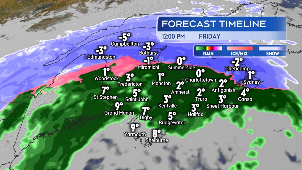 Snow and ice pellets turn to freezing rain and rain for much of the Maritimes Friday afternoon.
SNOW
The highest snowfall totals are expected in northern New Brunswick. The area from Edmundston to Bathurst could pick up 30 to 45 cm. Just south of that area, from Grand Falls to Miramichi, 20 to 30 cm is a reasonable expectation.
Woodstock, Fredericton, and eastward into western P.E.I. could pick up 10 to 20 cm of snow and ice pellets before a turn to freezing rain and rain.
Moncton, N.B., Charlottetown, and northern Cumberland County in Nova Scotia, as well as the Cape Breton Highlands, will see up to 10 cm before a turn to rain. The remainder of the Maritimes should generally see five cm or less of snow before a turn to rain.
Most of New Brunswick is under a winter storm warning. A snowfall warning is in effect for Prince and Queens counties on P.E.I.
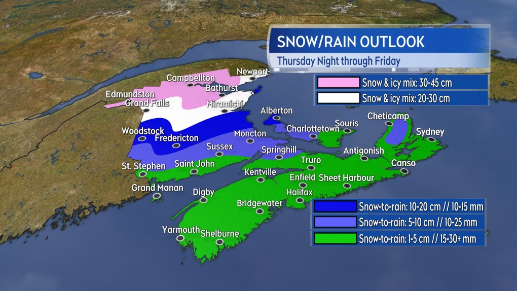 The most snow is expected in northern New Brunswick with progressively more rain expected south and east.
RAIN
Through Friday, the most rain is expected near the Bay of Fundy coastline of New Brunswick where rainfall warnings have been issued. Thirty to 50 mm of rain in that area could contribute to hydroplaning conditions on roads and localized flooding at low points in terrain.
Rain amounts of 10 to 25 mm are expected for P.E.I. and Nova Scotia on Friday. However, for both of those provinces, additional rain on Saturday could bring storm totals into the 30 to 50+ mm range.
Regardless, it's important to keep in mind that the winter ground is frozen and saturated in many areas, which will increase water runoff and associated issues.
It's recommended homeowners make sure property drainage is free and clear of snow and ice.
WIND
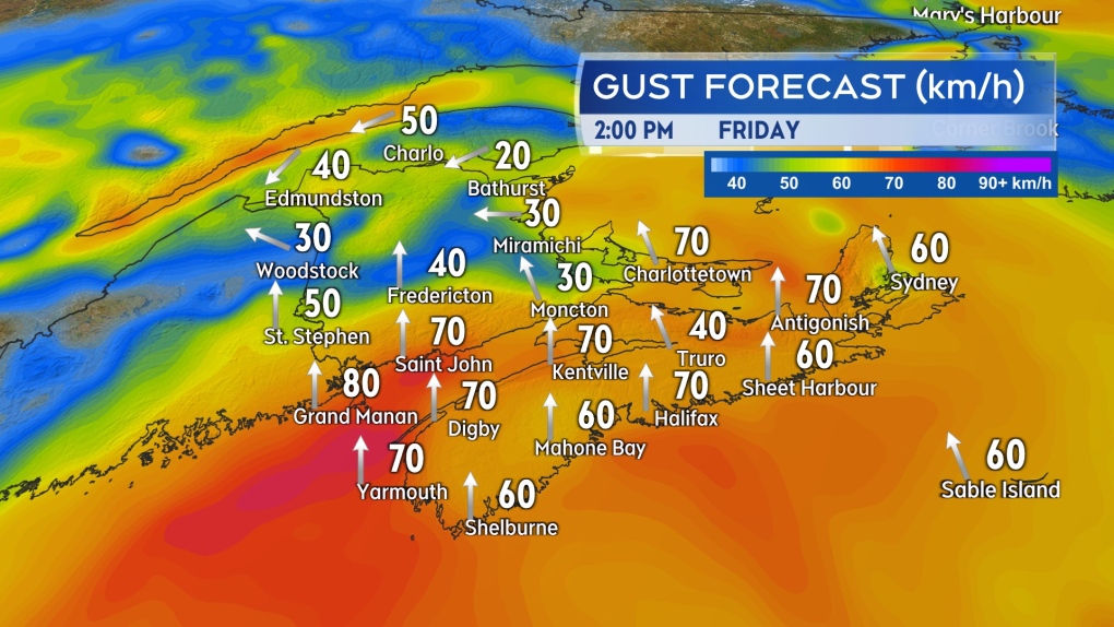
Widespread southerly wind gusts of 40 to 80 km/h are expected by Friday afternoon in the region. The strongest gusts are most likely on exposed areas of the coast and higher terrain.
Northern Inverness County in Cape Breton is under a wind warning for gusts that could reach as high as 130 km/h as a result of the topography of the Cape Breton Highlands.
The wind in northern New Brunswick will be lighter but also out of an east/northeast direction. That keeps that part of the Maritimes colder Friday, hence more snow and ice pellet accumulation.
The Confederation Bridge has an advisory out that traffic restrictions may be necessary Friday. Marine Atlantic is advising that the North Sydney – Port aux Basque sailing Friday into Saturday could be impacted.
 A gusty southerly wind will boost up temperatures for most of the Maritimes Friday. A colder east/northeast wind will be present in northern New Brunswick.
NOTES OF CAUTION
Driving conditions on roads for northern and central New Brunswick are likely to be terrible for much of Friday.
Residents should consider postponing non-essential travel if they can. Where the snow does add up to higher totals, it is going to have some weight to it. This is particularly true if ice pellets, freezing rain, and rain mix in.
Maritimers should take their time clearing and take breaks as needed to avoid physical strain.
The weighty snow also increases the risk of drooping or falling tree branches, which would add a risk of power outages should they contact lines.
Shopping Trends
The Shopping Trends team is independent of the journalists at CTV News. We may earn a commission when you use our links to shop. Read about us.


CTVNews.ca Top Stories

BREAKING
BREAKING Poilievre writes to GG calling for House recall, confidence vote after Singh declares he's ready to bring Liberals down
Conservative Leader Pierre Poilievre has written to Gov. Gen. Mary Simon, imploring her to 'use your authority to inform the prime minister that he must' recall the House of Commons so a non-confidence vote can be held. This move comes in light of NDP Leader Jagmeet Singh publishing a letter stating his caucus 'will vote to bring this government down' sometime in 2025.
'I understand there's going to be a short runway,' new minister says after Trudeau shuffles cabinet
Prime Minister Justin Trudeau added eight Liberal MPs to his front bench and reassigned four ministers in a cabinet shuffle in Ottawa on Friday, but as soon as they were sworn-in, they faced questions about the political future of their government, and their leader.
Judge sentences Quebecer convicted of triple murder who shows 'no remorse'
A Quebecer convicted in a triple murder on Montreal's South Shore has been sentenced to life in prison without chance of parole for 20 years in the second-degree death of Synthia Bussieres.
BREAKING
BREAKING Fake nurse Brigitte Cleroux sentenced to 7 years in prison
A woman who illegally treated nearly 1,000 patients in British Columbia while impersonating a nurse has been sentenced to seven years in prison.
Poilievre to Trump: 'Canada will never be the 51st state'
Conservative leader Pierre Poilievre is responding to U.S. president-elect Donald Trump’s ongoing suggestions that Canada become the 51st state, saying it will 'never happen.'
Toronto officials warn of possible measles exposure at Pearson airport
Toronto Public Health (TPH) is advising of another possible measles exposure at Canada’s largest airport.
Party City closing in U.S., Canadian stores remain 'open for business'
The impending closure of all Party City locations in the United States will not extend into Canada.
BREAKING
BREAKING At least one dead and 50 injured after a car drove into a German Christmas market, official says
A car plowed into a busy outdoor Christmas market in the eastern German city of Magdeburg on Friday, leaving at least one person dead and injuring at least 50 others in what authorities suspect was an attack.
Guelph man facing assault charge after police say he spat in roommate's face during disagreement over cat
A fight between roommates has led to an assault charge for a Guelph man.
Toronto
-

'Enough is enough': Toronto Jewish school struck by gunfire for third time since May
A Jewish elementary school in Toronto has been struck by gunfire for the third time in the last seven months.
-
Streetcar service resumes following 'extensive repairs' at King and Spadina intersection
Streetcar service has resumed at a major downtown intersection that had been closed since a garbage truck took down some overhead wires on Tuesday morning.
-
Police say break-and-enter suspects were in Canada for 'purpose of committing criminal offences'
Five Chilean nationals who police believe were in Canada for 'the purpose of committing criminal offences' have been charged in connection with half a dozen break-and-enters across the Greater Toronto Area (GTA).
Calgary
-

Calgary man arrested in connection with more than a dozen robberies
Police say charges have been laid against a 19-year-old man in connection with a series of robberies that targeted cannabis and convenience stores in Calgary and Edmonton.
-
Alberta announces plan to develop 'modernized' coal policy
The future of coal mining in Alberta will be governed by a new, modern approach, the province announced on Friday.
-
Here’s why your Calgary Enmax bill may go down in 2025
The City of Calgary had some good news for Calgary residents Friday morning, announcing that their Enmax bill may get a bit lower in 2025.
Edmonton
-

'I understand there's going to be a short runway,' new minister says after Trudeau shuffles cabinet
Prime Minister Justin Trudeau added eight Liberal MPs to his front bench and reassigned four ministers in a cabinet shuffle in Ottawa on Friday, but as soon as they were sworn-in, they faced questions about the political future of their government, and their leader.
-
4 new members appointed to Edmonton Police Commission
The city announced on Friday that Carola Cunningham, Zahro Hassan, Daniel Jones and Renée Vaugeois would be joining the commission on a two-year contract.
-
Be prepared for one of the busiest days at the Edmonton International Airport
The airport can be a busy place any day of the week, but Dec. 20 is expected to be one of the busiest days of the year at Edmonton International Airport .
Montreal
-

Judge sentences Quebecer convicted of triple murder who shows 'no remorse'
A Quebecer convicted in a triple murder on Montreal's South Shore has been sentenced to life in prison without chance of parole for 20 years in the second-degree death of Synthia Bussieres.
-
Suspect sought in abduction, attempted homicide case: police
A woman in her 20s who was possibly abducted by her ex is in hospital after the car she was in plunged into the Richelieu River.
-
Smash and grab caught on camera in Montreal boutique
Montreal designer Jennifer Glasgow is sounding the alarm about break-ins in her neighbourhood after thieves broke into her boutique and made off with clothing and jewelry.
Ottawa
-

Man allegedly filming females in public washroom in business on Elgin Street, police looking for more victims
The Ottawa Police Service says a man has been arrested following a report alleging he was filming women inside a public washroom in a business on Elgin Street last weekend.
-
LISTEN
LISTEN Opposition leader speaks with The Morning Rush with Bill Carroll
The leader of the Conservative Party of Canada and the leader of the opposition in the House of Commons commented on multiple key issues Thursday morning in an exclusive interview with The Morning Rush with Bill Carroll.
-
‘Hot and frosty’: Film industry booming in Ottawa
Ottawa is not only a hot spot for tourism, but also a landmark when it comes to the film industry and holiday movies, says the City of Ottawa.
London
-

Man dies after falling from building: LPS
London police say a man has died after falling from a building.
-
Manslaughter charge laid against London man after August drug bust
A London man has been charged with manslaughter after an OPP drug raid this summer. Police have released few details but say they used a search warrant at a West Elgin home Aug. 23.
-
Snow squall watch issued for London region
A snow squall watch is in effect for Middlesex County, Lambton County, Huron, and southern Bruce. This is due to the system snow that's moved through, associated with a clipper that is now driving off to the south.
Barrie
-

Multi-vehicle collision on Highway 11 in Oro-Medonte
Southbound traffic along Highway 11 through Oro-Medonte was brought to a crawl Friday after a multi-vehicle collision.
-
High school teacher charged with sexual assault amid allegations involving a student
A 51-year-old teacher from Georgina has been charged with sexual assault following allegations involving a student.
-
Driver charged after vehicle crashes into Barrie home
A driver was arrested Thursday night after a vehicle crashed into a home in Barrie.
Northern Ontario
-
BREAKING
BREAKING Poilievre writes to GG calling for House recall, confidence vote after Singh declares he's ready to bring Liberals down
Conservative Leader Pierre Poilievre has written to Gov. Gen. Mary Simon, imploring her to 'use your authority to inform the prime minister that he must' recall the House of Commons so a non-confidence vote can be held. This move comes in light of NDP Leader Jagmeet Singh publishing a letter stating his caucus 'will vote to bring this government down' sometime in 2025.
-
Northern Ont. man illegally killed three moose, one deer
A man from the northwestern Ontario community of Dinorwic has been found guilty of multiple hunting offences and fined $6,500, banned from hunting for five years and placed on probation for 18 months.
-
North Bay-area man wanted on 19 charges, including spousal assault, drug trafficking
Police are asking for the public's help in finding a suspect wanted for a host of offences, ranging from assault to uttering death threats.
Kitchener
-

Guelph man pleads guilty to fleeing fatal crash involving cyclist
A Guelph driver, who previously admitted to failing to stop after a fatal crash, instead plead guilty to a different charge on Friday.
-
Police believe shots fired into Cambridge home was a targeted incident
Waterloo Regional Police Service now believes shot fired into a Cambridge home was a targeted incident.
-
Homeowners in Waterloo Region to pay 9.48 per cent more on region's 2025 property tax bill
After councillors failed to set Waterloo Region’s 2025 budget in a marathon meeting earlier this month, councillors gathered again on Thursday to try to hammer down what was once a 10.45 per cent property tax hike.
Windsor
-

Over $45,000 in cash and drugs seized: WPS
Two suspects have been arrested and over $45,000 in cash and drugs seized following an investigation by the Windsor Police Service (WPS).
-
Toll increase coming to the Windsor-Detroit Tunnel in 2025
Drivers heading through the Windsor-Detroit Tunnel in the new year will have to take some extra cash. A toll increase for those heading from Canada to the U.S. is scheduled for Jan. 1, 2025 .
-
Life-threatening injuries after ATV crash in Lakeshore
Around 4:20 p.m. on Thursday, police, fir and EMS were called to Lakeshore Road 302 for a crash involving an ATV.
Winnipeg
-

Bail denied for Winnipeg woman accused of killing animals in online videos
Warning: This story contains disturbing details. Discretion is advised. A Winnipeg woman accused of making videos of animals being tortured and killed that were sold on the dark web was denied bail.
-
Ontario town seeks judicial review after being fined $15K for refusing to observe Pride Month
An Ontario community fined $15,000 for not celebrating Pride Month is asking a judge to review the decision.
-
BREAKING
BREAKING Poilievre writes to GG calling for House recall, confidence vote after Singh declares he's ready to bring Liberals down
Conservative Leader Pierre Poilievre has written to Gov. Gen. Mary Simon, imploring her to 'use your authority to inform the prime minister that he must' recall the House of Commons so a non-confidence vote can be held. This move comes in light of NDP Leader Jagmeet Singh publishing a letter stating his caucus 'will vote to bring this government down' sometime in 2025.
Regina
-

Highway closures in place as winter driving conditions return
After receiving another big dump of snow over the past couple of days, Saskatchewan drivers have had to contend with some treacherous driving conditions.
-
Local groups work to give people extra support this holiday season
As the holidays approach, outreach groups are working to give people in the community a bit of extra support.
-
Appeal dismissed in Sask. 'thumbs up' emoji case
An appeal to a legal case that made international headlines has been dismissed by Saskatchewan's highest court.
Saskatoon
-

'An absolute blessing': Milgaard's Law receives royal assent, giving hope to the wrongfully convicted
Bill C-40, the Miscarriage of Justice Review Commission Act, better known as David and Joyce Milgaard’s Law, received royal assent Tuesday.
-
Saskatchewan highway closed due to serious collision
The Saskatoon RCMP are currently responding to a serious collision on Highway 5, west of Meacham.
-
How do THC gummies impact driving? Sask. researchers use simulator to find out
Researchers at the University of Saskatchewan are conducting a study to learn how THC edibles impact driving performance.
Vancouver
-

City confirms Stanley Park Train cancelled for the holiday season
Rides on Stanley Park’s iconic Christmas train will be shelved for another year for thousands of ticket holders, as officials confirm the train’s closure will continue for the remainder of the holiday season.
-
BREAKING
BREAKING Fake nurse Brigitte Cleroux sentenced to 7 years in prison
A woman who illegally treated nearly 1,000 patients in British Columbia while impersonating a nurse has been sentenced to seven years in prison.
-
BC Civil Liberties Association calls for review of MAID legislation
The British Columbia Civil Liberties Association is calling on the provincial and federal governments to review medically-assisted dying legislation to ensure proper safeguards are in place.
Vancouver Island
-

Victoria police make 42 arrests in retail theft crackdown
Police in Victoria say officers have made 42 arrests and recovered approximately $10,000 in stolen merchandise during a four-day retail theft operation targeting repeat offenders.
-
Loans, delays, legal action: B.C. renovator blames illness for project stalls, denies faking cancer
Two Metro Vancouver homeowners have come forward with new allegations against a local renovator accused of faking cancer to avoid repaying a debt, saying they are also owed money after handing over hefty sums for projects that have not been completed.
-
BC Civil Liberties Association calls for review of MAID legislation
The British Columbia Civil Liberties Association is calling on the provincial and federal governments to review medically-assisted dying legislation to ensure proper safeguards are in place.
Kelowna
-

Forfeited Hells Angels clubhouse in Kelowna, B.C., sold to the city
A former Hells Angels clubhouse that was seized by the British Columbia government in 2023 after years of fighting in court has been sold to the City of Kelowna.
-
Death of woman found in Kelowna's Waterfront Park in June deemed 'non-criminal in nature': RCMP
Police in Kelowna say a death they began investigating back in June has now been confirmed as "non-criminal in nature."
-
B.C. man sentenced for 'execution-style' murder of bystander in drug trade conflict
A B.C. man convicted of the "intentional and ruthless killing of a bystander" while acting as an enforcer in the drug trade has been sentenced for a second time in the slaying.


