Winter storm watch in New Brunswick; heavy snow, rain forecast for Maritimes Thursday
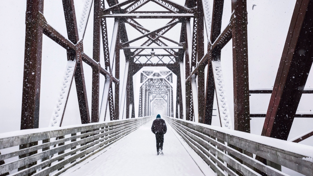
 A man walks across a pedestrian bridge during a snow storm in Fredericton on Sunday, December 27, 2015. THE CANADIAN PRESS/Darren Calabrese
A winter storm watch has been issued for northern New Brunswick Wednesday night into Thursday.
Environment Canada's watch calls for potential snow amounts of up to 30 cm late Wednesday night through Thursday. The snow may mix with ice pellets and freezing rain.
Gusty winds will create areas of blowing snow, which could reduce visibility. The weather office is cautioning that “travel in areas of northern New Brunswick, especially on remote highways, will become hazardous, especially on Thursday.”
Other parts of the Maritimes will likely see some snow to start, before turning over to rain in a strong southerly wind. The rain is expected to be heavy at times for some areas.
Rain, along with melting snow, will create a risk of localized flooding and hydroplaning conditions.
TIMING
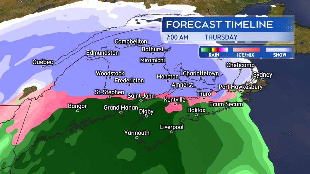
Snow is expected to reach western New Brunswick near midnight Wednesday into Thursday. Around the same time, a mix of snow turning to rain will arrive in southwestern Nova Scotia.
By early Thursday morning, falling snow will be across New Brunswick and Prince Edward Island. Nova Scotia will see snow turn to rain Thursday morning.
By Thursday mid-afternoon, the snow will have turned to rain for most of the Maritimes. The northernmost areas of New Brunswick is expected to see a mix of snow, ice pellets, and freezing rain continuing into the evening.
Snow and rain will clear the Maritimes west-to-east Thursday night.
 Snow and snow turning to rain will be present across the Maritimes Thursday morning. A turn to rain will happen for all but northern areas of New Brunswick by mid-afternoon.
AMOUNTS
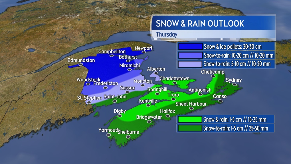
Snow and ice pellets reaching 20-plus cm looks most likely along and north of a line from Woodstock, N.B., to Miramichi, N.B.
Fredericton could see 10 to 20 cm of snow before the turn to rain. Less snow, but more rain, is expected near the Bay of Fundy coastline of New Brunswick.
Likewise, while there will be some accumulating snow to start, a quicker turn to rain should hold that snow to five cm or less for most of P.E.I. and Nova Scotia. Kings County in P.E.I. could pick up five to 10 cm before the change to rain. Higher rainfall totals of up to 50 mm are possible for parts of Nova Scotia.
Temperatures will fall back below freezing Thursday night into Friday morning. Wet and slushy surfaces will freeze as that happens.
The entirety of the region should be cautious of icy surfaces present for Friday.
 The most snow and ice pellet accumulation is expected in northern areas of the New Brunswick. The area is currently under a winter storm watch.
WIND AND WAVES
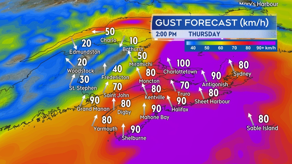
The snow and rain will be accompanied by a strong southerly wind for most of the Maritimes. The wind will build Thursday to reach peak gusts of 60 to 80 km/h for southern New Brunswick, P.E.I., and Nova Scotia. Stronger gusts of 80 to 100 km/h may occur at exposed areas of the coast and higher terrain.
Peak gusts near 120 km/h are likely in northern Inverness County in Cape Breton due to the topography of the Highlands.
The wind in northwestern New Brunswick won’t be as strong and will be out of the northeast. That will keep colder air in place, hence why that part of the Maritimes is expecting more snow and ice pellet accumulation.
The strong onshore winds will pose a risk of elevated coastal water levels and large, crashing waves for a number of areas.
Environment Canada is advising in special weather statements that south-facing coastlines of Nova Scotia, as well as coastal areas of the Bay of Chaleur in northeastern New Brunswick, are most at risk for those conditions. The risk will be highest during Thursday afternoon high tides.
 Strong southerly wind gusts will create periods of wind driven rain and rough coastal conditions.
CTVNews.ca Top Stories

Canadian team told Trump's tariffs unavoidable in short term in surprise Mar-a-Lago meeting
During a surprise dinner at Mar-a-Lago, representatives of the federal government were told U.S. tariffs from the incoming Donald Trump administration cannot be avoided in the immediate term, two government sources tell CTV News.
Toronto man accused of posing as surgeon, performing cosmetic procedures on several women
A 29-year-old Toronto man has been charged after allegedly posing as a surgeon and providing cosmetic procedures on several women.
W5 Investigates 'I never took part in beheadings': Canadian ISIS sniper has warning about future of terror group
An admitted Canadian ISIS sniper held in one of northeast Syria’s highest-security prisons has issued a stark warning about the potential resurgence of the terror group.
Trump threatens 100% tariff on the BRIC bloc of nations if they act to undermine U.S. dollar
U.S. president-elect Donald Trump on Saturday threatened 100 per cent tariffs against a bloc of nine nations if they act to undermine the U.S. dollar.
'Disappointing': Toronto speed camera cut down less than 24 hours after being reinstalled
A Toronto speed camera notorious for issuing tens of thousands of tickets to drivers has been cut down again less than 24 hours after it was reinstalled.
Poilievre suggests Trudeau is too weak to engage with Trump, Ford won't go there
While federal Conservative Leader Pierre Poilievre has taken aim at Prime Minister Justin Trudeau this week, calling him too 'weak' to engage with U.S. president-elect Donald Trump, Ontario Premier Doug Ford declined to echo the characterization in an exclusive Canadian broadcast interview set to air this Sunday on CTV's Question Period.
Bruce the tiny Vancouver parrot lands internet fame with abstract art
Mononymous painter Bruce has carved a lucrative niche on social media with his abstract artworks, crafted entirely from the colourful juices of fruits.
Why this Toronto man ran so a giant stickman could dance
Colleagues would ask Duncan McCabe if he was training for a marathon, but, really, the 32-year-old accountant was committing multiple hours of his week, for 10 months, to stylistically run on the same few streets in Toronto's west end with absolutely no race in mind. It was all for the sake of creating a seconds-long animation of a dancing stickman for Strava.
Mont-Tremblant World Cup skiing races cancelled due to warm weather
Fans hoping to see the world's top woman skiers compete next week in Mont-Tremblant, Que., are out of luck after the PwC Tremblant World Cup was cancelled due to warm weather.


