April snowfall not expected to break previous snowfall records in Maritimes
 A pedestrian makes their way through the downtown as heavy snow and gusting winds continue to hit Halifax on Sunday, Feb. 4, 2024. (THE CANADIAN PRESS/Darren Calabrese)
April snow
A low pressure system moving up the eastern seaboard will bring a mix of snow and rain to the Maritimes Thursday and Friday. The western portion of the system will bring a similar mix to parts of Ontario and Quebec. With the possibility of snow and slushy accumulation, Environment Canada has issued special weather statements for the Maritimes.
There are some pretty impressive standing snow records for April 4 in the Maritimes. For example, Bathurst, N.B., recorded 61 cm of snow on April 4, 1975, and Ingonish, N.S., recording 48 cm of snow from the same system on the same date. This snow is not going to challenge those more impressive and long-standing early April snow records.
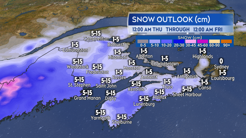
Wednesday night and Thursday
The first of the snow will reach southwestern New Brunswick and southwestern Nova Scotia Wednesday overnight. The snow will then develop across New Brunswick and mainland Nova Scotia Thursday morning and Thursday afternoon. The snow is expected to be “wet” and likely mixed with rain for parts of southern New Brunswick and Nova Scotia.
Prince Edward Island and Cape Breton will have a chance of flurries or showers beginning Thursday afternoon, before getting into a mix of wet snow and rain Thursday evening.
Snow amounts of five to 15 cm are possible across western New Brunswick and western mainland Nova Scotia through Thursday. One to five centimetres is expected for the remainder of the Maritimes. Snowy or slushy accumulations through the day could make for slippery roads, parking lots, and driveways.
 Possible snow on Thursday. Accumulation will depend on melting and if rain mixes in. (CTV/Kalin Mitchell)
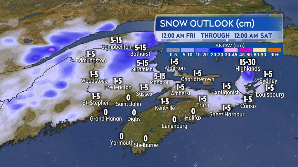
Friday
What remains of the steadier snow and rain mix moves into eastern parts of the Maritimes Thursday overnight and Friday. Additional snow amounts of five to 15 cm is possible in eastern New Brunswick including areas from Moncton north to Bathurst and the Acadian Peninsula. The more mountainous terrain of northeastern New Brunswick and the elevations of the Cape Breton Highlands could pick up 15 to 30 cm of snow.
The rest of the Maritimes will see a mix of showers and flurries on Friday.
 Possible snow on Friday. The most expected in eastern areas of New Brunswick and the higher terrain of Cape Breton. (CTV/Kalin Mitchell)
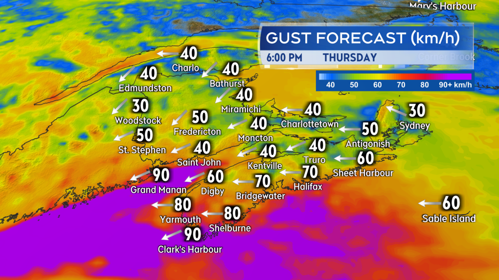
Wind
A gusty easterly wind will accompany the mix of snow and rain on Thursday. Peak gusts could reach 50 to 70 km/h for southern New Brunswick, Nova Scotia, and Prince Edward Island. Exposed coastal areas of the Bay of Fundy in New Brunswick and the southwest coastline of Nova Scotia could experience wind gusts as high as 70 to 100 km/h.
Wind on Friday will be from the east and southeast with fairly widespread gusts of 30 to 60 km/h for the Maritimes.
 A high and gusty easterly wind accompanies the mix of snow and rain on Thursday for parts of the Maritimes. (CTV/Kalin Mitchell)
Shopping Trends
The Shopping Trends team is independent of the journalists at CTV News. We may earn a commission when you use our links to shop. Read about us.


CTVNews.ca Top Stories

'Canadians deserve a real choice': Justin Trudeau resigning, prorogues Parliament
Prime Minister Justin Trudeau is stepping down as Liberal leader, and is proroguing Parliament as the Liberal Party of Canada embarks on the journey to replace him.
WATCH LIVE
WATCH LIVE Justin Trudeau resigns as Liberal leader: Follow live updates
Prime Minister Justin Trudeau has stepped down as Liberal leader. Follow along for live updates from CTVNews.ca.
'Together, what a great nation it would be': Donald Trump, Elon Musk react to Justin Trudeau's resignation
Amid news of Prime Minister Justin Trudeau's resignation as leader of the Liberal party on Monday morning, reactions from prominent figures began piling in.
Justin Trudeau is resigning, what will be his legacy? A look back at key political eras
In a seismic political move, Justin Trudeau has announced his intention to step down as leader of the Liberal Party of Canada and prime minister, once his successor is named. This decision comes after more than nine years in the country's top job and nearly 12 years at the helm of his party.
Trudeau says Parliament is 'prorogued' until March. What does that mean?
In his resignation speech on Monday, Prime Minister Justin Trudeau announced that Parliament would be prorogued until March, which will give the Liberal party time to find a new leader ahead of an expected confidence vote and early election.
Justin Trudeau resignation: Here's what he said in Ottawa today
Prime Minister Justin Trudeau delivered a speech about his political future Monday morning outside Rideau Cottage in Ottawa. Here's the message he delivered to Canadians.
Alberta government signs new oil and gas agreement with Enbridge
The Alberta government has signed an agreement with Enbridge that Premier Danielle Smith says will increase exports of the province's heavy oil to the United States.
Judge condemns murder trial delay, asks lawyers to 'turn around' and look at the public 'we serve'
A Saskatoon murder trial opened on Monday with the judge sharply criticizing the time it’s taken to get to trial.
Doug Ford snaps back at Donald Trump's Canada taunts with offer to 'buy Alaska'
Ontario Premier Doug Ford has snapped back at Donald Trump’s frequent taunts about treating Canada as a U.S. state with a counterproposal: buying Alaska.
Toronto
-
'Canadians deserve a real choice': Justin Trudeau resigning, prorogues Parliament
Prime Minister Justin Trudeau is stepping down as Liberal leader, and is proroguing Parliament as the Liberal Party of Canada embarks on the journey to replace him.
-
Doug Ford snaps back at Donald Trump's Canada taunts with offer to 'buy Alaska'
Ontario Premier Doug Ford has snapped back at Donald Trump’s frequent taunts about treating Canada as a U.S. state with a counterproposal: buying Alaska.
-
Canadian alleged drug lord Ryan Wedding still has access to 'network of hitmen': U.S. prosecutors
U.S. prosecutors are seeking additional protections to keep the identities of confidential informants and co-operating witnesses hidden in the case against Ryan James Wedding, as the search continues for the Canadian ex-Olympian and alleged drug lord.
Calgary
-
'Canadians deserve a real choice': Justin Trudeau resigning, prorogues Parliament
Prime Minister Justin Trudeau is stepping down as Liberal leader, and is proroguing Parliament as the Liberal Party of Canada embarks on the journey to replace him.
-
Alberta government signs new oil and gas agreement with Enbridge
The Alberta government has signed an agreement with Enbridge that Premier Danielle Smith says will increase exports of the province's heavy oil to the United States.
-
Canadian oil stocks climb as industry absorbs news of Trudeau resignation
Canadian oil and gas stocks climbed Monday as the country's energy sector absorbed the news of Prime Minister Justin Trudeau's resignation.
Edmonton
-
'Canadians deserve a real choice': Justin Trudeau resigning, prorogues Parliament
Prime Minister Justin Trudeau is stepping down as Liberal leader, and is proroguing Parliament as the Liberal Party of Canada embarks on the journey to replace him.
-
Teen charged in stabbing at Alberta recreation centre
A teen boy has been charged after a stabbing at a northern Alberta recreation centre.
-
More than 1,000 Fort McMurray school support workers to strike on Tuesday
Public and Catholic school support workers in Fort McMurray are slated to walk off the job Tuesday morning after holding rotating strikes since Nov. 13.
Montreal
-

'It was the right decision': Quebec politicians, residents react to Trudeau resignation
Elected officials in Quebec were quick to react to the major announcement in Ottawa Monday about Prime Minister Justin Trudeau and the path forward for the federal Liberal Party.
-
Man, 27, injured in possible stabbing in Plateau-Mont-Royal
A 27-year-old man was sent to hospital with serious injuries after a possible stabbing in broad daylight Monday afternoon.
-
'Canadians deserve a real choice': Justin Trudeau resigning, prorogues Parliament
Prime Minister Justin Trudeau is stepping down as Liberal leader, and is proroguing Parliament as the Liberal Party of Canada embarks on the journey to replace him.
Ottawa
-
'Canadians deserve a real choice': Justin Trudeau resigning, prorogues Parliament
Prime Minister Justin Trudeau is stepping down as Liberal leader, and is proroguing Parliament as the Liberal Party of Canada embarks on the journey to replace him.
-
Ottawa's new north-south O-Train opens to the public
A large crowd gathered at Bayview Station just before 6 a.m. for a chance to be the first person to ride on the new north-south Line 2 Monday morning. The new north-south Line 2 and Line 4 runs from Bayview Station to Riverside South, with a link to the Ottawa International Airport.
-
Meet the winners of the CHEO Dream of a Lifetime Lottery grand prize
Tracey Lavergne of Woodlawn, Ont. is starting off the new year with a new Minto Dream Home in Manotick, the grand prize in the CHEO Dream of a Lifetime Lottery.
London
-

London MPs say the prime minister's decision to step down is the right one
London North West Liberal MP Peter Fragiskatos made his thoughts clear on Justin Trudeau’s leadership over the weekend, "I did call for the prime minister to resign for a number of reasons. His continued leadership was not tenable."
-
Strangulation attack inside Sarnia church sparks security review
The incident happened Saturday inside the Adoration Chapel at Our Lady of Mercy Catholic Church - the chapel is available 24 hours a day for those who know the door code to enter.
-
Body found on Lake Erie shoreline prompts death investigation
Elgin County OPP are investigating after a deceased individual was discovered on the shoreline of Lake Erie in the township of Malahide.
Barrie
-

Collision involving snowmobile at Hwy 12 crossing under investigation
Provincial police are investigating a collision involving a snowmobile in Midland.
-
Former Snowbirds pilot charged with sexual assault testifies in Barrie court
A former Canadian Forces Snowbirds pilot accused of forcing himself on a colleague before last summer’s airshow in Barrie took the stand to clear his name in court on Monday.
-
Rookie driver charged with speeding over 2x posted limit: OPP
Provincial police say a G2 driver faces serious charges after being clocked speeding more than double the posted limit in the Town of New Tecumseth over the weekend.
Northern Ontario
-
'Canadians deserve a real choice': Justin Trudeau resigning, prorogues Parliament
Prime Minister Justin Trudeau is stepping down as Liberal leader, and is proroguing Parliament as the Liberal Party of Canada embarks on the journey to replace him.
-
Two Greater Sudbury drivers charged in racing incident on Hwy. 69
Ontario Provincial Police stopped to vehicles travelling more than double the speed limit on Highway 69 south of Greater Sudbury, early Friday morning.
-
Province boosts Sudbury's annual funding by $2.7M
The City of Greater Sudbury is one of more than 300 municipalities receiving an increase to their annual provincial funding this year.
Kitchener
-

Social media famous corgi from Kitchener, Ont. rescues owner
A captivating canine is being hailed as a hero after one of his owners took a terrifying fall.
-
New threshold for reporting collisions in Ontario
Ontario has increased the threshold dictating when drivers are required to report a collision to police.
-
'Canadians deserve a real choice': Justin Trudeau resigning, prorogues Parliament
Prime Minister Justin Trudeau is stepping down as Liberal leader, and is proroguing Parliament as the Liberal Party of Canada embarks on the journey to replace him.
Windsor
-

Three gunpoint robbery suspects sought, one arrested
Windsor police officers have arrested one suspect and they are looking for three others after an armed robbery on University Avenue.
-
Selfish? Strategic? Windsor-Essex MP’s weigh-in on Trudeau resignation
Prime Minister Justin Trudeau announced Monday he is proroguing Parliament and will resign once a new leader is elected to the Liberal Party of Canada.
-
St. Clair College students face uncertainty as strike deadline looms
St. Clair College students began their winter semester Monday under a cloud of uncertainty, with the threat of a faculty strike just days away.
Winnipeg
-

'Different life to the party': Manitoba weighs in on Trudeau’s resignation
Manitobans are reacting to Justin Trudeau’s resignation as Liberal leader and his decision to prorogue to Parliament until March to allow for a leadership race.
-
Injunction extended against protesters in Lemay Forest
A court-ordered injunction against a group protesting the clearing of a Winnipeg forest will remain in place.
-
Man charged with voyeurism at Winnipeg fitness facility
A 26-year-old man has been charged with voyeurism after he allegedly snapped photos of a child undressing in a change room at a Winnipeg fitness facility.
Regina
-

Sask. RCMP make arrest in suspicious death on Piapot First Nation
Saskatchewan RCMP have arrested and charged Robin Kaiswatum, 40, with second degree murder in connection to a death on Piapot First Nation.
-
Saskatchewan politicians react to Trudeau's resignation announcement
Following Prime Minister Justin Trudeau's resignation announcement on Monday, reaction from politicians around the world quickly began to circulate, including in Saskatchewan.
-
'Everything I've ever dreamed of': Regina Cougars curling to represent Canada at World University Games
The University of Regina Men's Curling team is preparing for the international stage as they gear up as Team Canada for the 2025 FISU Winter World University Games.
Saskatoon
-

Judge condemns murder trial delay, asks lawyers to 'turn around' and look at the public 'we serve'
A Saskatoon murder trial opened on Monday with the judge sharply criticizing the time it’s taken to get to trial.
-
These 90-year-old identical twins were born in a Saskatchewan barn, but grew to love the city
Rose Worona and Anne Skwarchuk were born in 1935 on a farm near Hafford. Now, they’re celebrating their 90th birthday together.
-
Province calling for prospective builders on new Sask. Polytech campus in Saskatoon
The province is putting out the call to prospective builders for a major project on the new Saskatchewan Polytechnic campus planned in Saskatoon.
Vancouver
-

Hidden in plain sight: Human trafficking and the B.C. connection
You may not see if or even know it’s happening in your community. But it is an evil shrouded in the dark shadows of society, and even experts do not know its full scope.
-
'Canadians deserve a real choice': Justin Trudeau resigning, prorogues Parliament
Prime Minister Justin Trudeau is stepping down as Liberal leader, and is proroguing Parliament as the Liberal Party of Canada embarks on the journey to replace him.
-
CBSA says it acted in 'good faith' detaining solar panels in forced labour probe
The Canada Border Services Agency says it acted lawfully and in "good faith" when it detained nearly 50 containers of solar panels belonging to a Victoria, B.C., company over concerns they were made using forced labour.
Vancouver Island
-

CBSA says it acted in 'good faith' detaining solar panels in forced labour probe
The Canada Border Services Agency says it acted lawfully and in "good faith" when it detained nearly 50 containers of solar panels belonging to a Victoria, B.C., company over concerns they were made using forced labour.
-
Victoria police cleared of wrongdoing in crash that killed 24-year-old taxi driver
British Columbia's police oversight agency has cleared Victoria police officers of wrongdoing after an attempted traffic stop on a city street led to the death of an innocent man last year.
-
Hidden in plain sight: Human trafficking and the B.C. connection
You may not see if or even know it’s happening in your community. But it is an evil shrouded in the dark shadows of society, and even experts do not know its full scope.
Kelowna
-

Lost skiers rescued off B.C. mountain
Search and rescue volunteers in B.C.’s Okanagan successfully reunited two skiers with their family Friday evening.
-
Charges laid after child porn investigation that 'spanned several different countries,' Kelowna RCMP say
Police in Kelowna say an international investigation has led to child pornography charges against a 46-year-old man.
-
Mounties investigate discovery of 'very small pipe bomb' in Kamloops, B.C.
Mounties are investigating and appealing for witnesses after an explosive device was discovered Wednesday on a beach in Kamloops, B.C.


